National Grid Shares Proposals For Green Electricity Projects In Lincolnshire And West Norfolk, Needed To Boost Home-Grown Energy Supplies And Progress Towards Net Zero
The title of this post, is the same as that of this press release from National Grid.
These four bullet points, act as sub-headings.
- National Grid is inviting communities in East Lindsey, Boston and South Holland in Lincolnshire, and King’s Lynn and West Norfolk, to view proposals for two new primarily offshore electricity infrastructure projects.
- National Grid will consult communities from 23 April – 17 June to introduce the proposed project and ask for local peoples’ opinions.
- Eastern Green Link 3 (EGL 3) and Eastern Green Link 4 (EGL 4) will be able to transport enough clean energy generated in Scotland to power up to four million homes in the Midlands and South of England.
- The projects form part of The Great Grid Upgrade, the largest overhaul of the grid in generations, with new infrastructure across England and Wales helping the UK to meet its net zero ambitions, reduce its reliance on fossil fuels and contribute to lower energy bills over the long-term.
These five paragraphs outline the two projects.
National Grid is inviting communities to comment on early proposals for two green electricity infrastructure projects which will help deliver the UK’s energy security strategy and net zero targets.
The eight-week initial consultation, which begins on 23 April, shares proposals for Eastern Green Link 3 (EGL 3) and Eastern Green Link 4 (EGL 4) projects – two new, primarily subsea high voltage direct current (HVDC) electricity links, with associated infrastructure, between Scotland and England.
National Grid Electricity Transmission (NGET) is jointly developing EGL 3 with SSEN Transmission (SSEN) and EGL 4 with SP Energy Networks (SPEN).
EGL 3 would run from Peterhead, Aberdeenshire, under the North Sea via marine cables to a potential landfall location on the Lincolnshire coastline, either at Theddlethorpe or Anderby Creek. EGL 4 would run from Westfield, Fife, also via marine cables under the North Sea to the same landfall location as EGL 3.
After making landfall, both projects’ cables will run underground for approximately 100km to two proposed converter stations in the Walpole, King’s Lynn and West Norfolk, area. Underground cables would then connect the converter stations to the transmission network via a new proposed substation, also within the Walpole area.
Note.
- These would appear to be early proposals.
- National Grid appear to be planning and consulting on two interconnectors at once.
- There would appear to be a lot of underground cable on land. But then the cables will be dug into good Fenland soil.
- All the electrical gubbins seem to be in the Walpole area.
These paragraphs invite people to comment.
Throughout our initial consultation, we are holding a series of face-to-face events to consult on the electrical infrastructure required in England.
Our consultation events are being held across the project area. Information about our proposals will be on display and copies of maps and technical documents will be available to view. Members of the project team will be available to talk through our proposals and answer any questions.
National Grid have also announced dates of when public information events are being held.
- Tuesday 30 April 2024 – 2pm-7pm – Dunes Complex, Central Promenade, Mablethorpe, LN12 1RG
- Wednesday 1 May 2024 – 2pm-7pm – Anderby Village Hall, Sea Road, Anderby, Skegness, PE24 5YD
- Thursday 9 May 2024 – 12:30pm – 6pm – Alford Corn Exchange, 9 Market Place, Alford, LN13 9EB
- Monday 13 May 2024 – 2pm-7pm – Leverington Village Hall, Gorefield Rd, Leverington, Wisbech, PE13 5AT
- Wednesday 15 May 2024 – 2pm-7pm – Eastville, Midville and New Leake Village Hall, Station Rd, Eastville, PE22 8LS
- Thursday 16 May 2024 – 2pm-7pm – Poachers Country Hotel, Swineshead Road, Kirton Holme, PE20 1SQ
- Monday 20 May 2024 – 2pm-7pm – Walpole Community Centre, Summer Close, Walpole St Andrew, PE14 7JW
- Wednesday 29 May 2024 – 2pm-7pm – The Holbeach Hub, Boston Rd South, Holbeach, PE12 7LR
- Wednesday 5 June 2024 – 2pm-7pm – Burgh le Marsh Village Hall, Jacksons Lane, Burgh le Marsh, Skegness, PE24 5LA
I would have hoped, that some of the venues would have been easier to get to by public transport.
I have some thoughts and observations.
What Will Be The Capacity Of Green Link 3 And Green Link 4?
I can find references to the capacity of Eastern Green Links 1-4 and it appears that all four have a capacity of 2 GW.
A Map Of Green Link 3 And Green Link 4
I have found this map of Green Link 3 and Green Link 4.

National Grid are going to be busy, as they’re also building Green Link 1 and Green Link 2.
Will Green Link 3 And Green Link 4 Share A Route Between The Coast And Walpole?
There is only one green HVDC onshore cable on the map. But surely laying two 2 GW cables in the same trench will cost less, than digging two cable routes.
Looking at the three converter stations would appear to confirm that Green Link 3 and Green Link 4 share a route.
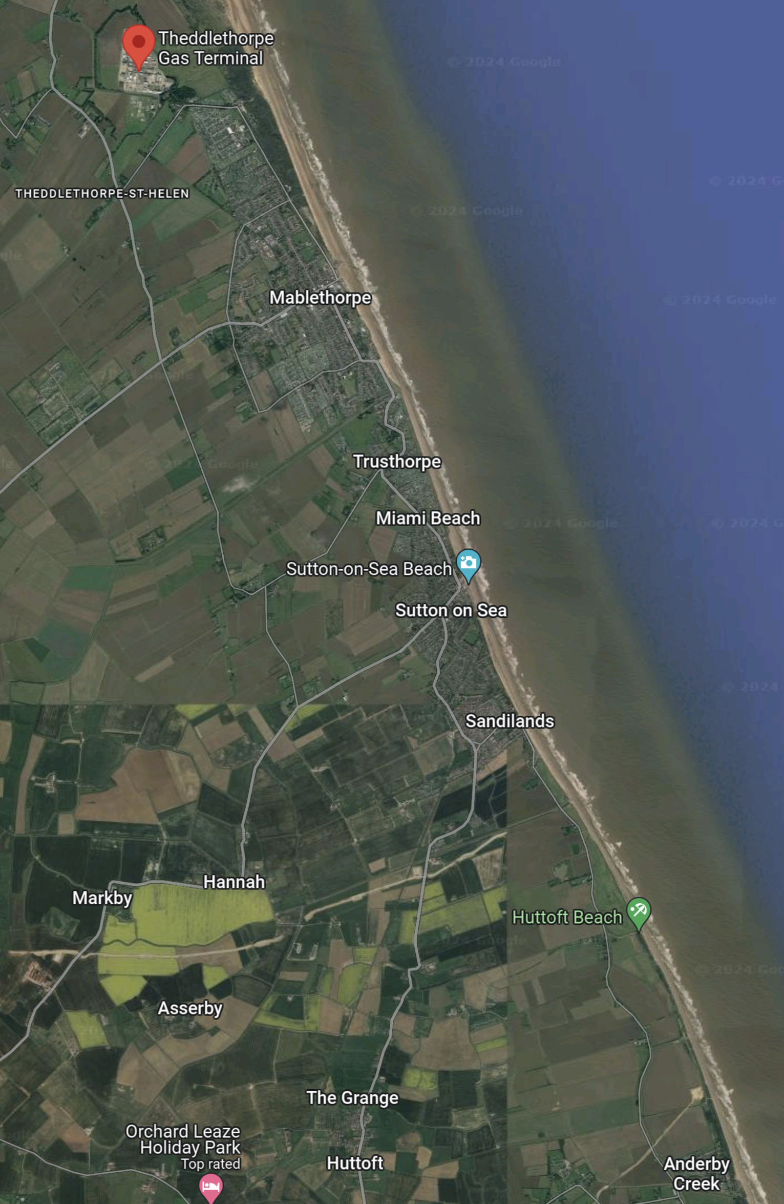
Will Landfall Be At Theddlethorpe Or Anderby Creek?
This Google Map shows the coast between Theddlethorpe and Anderby Creek.
Note.
- The decommissioned Theddlethorpe gas terminal is indicated by the red arrow.
- The seaside resort of Mablethorpe lies between the two possible landing sites.
- Anderby Creek is in the South-East corner of the map.
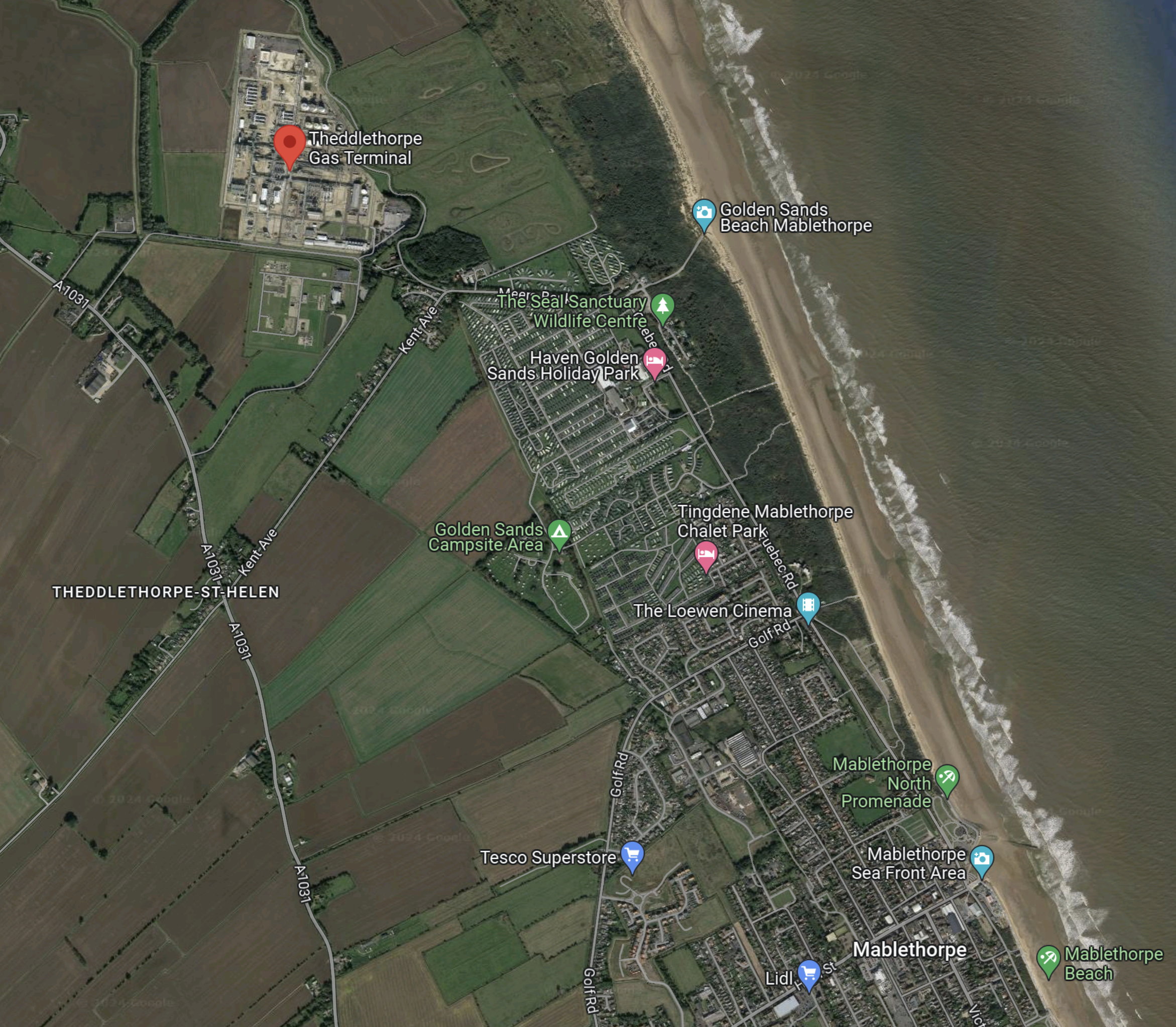
This second Google Map shows the Theddlethorpe Gas Terminal and the North of Mablethorpe.
Note.
- The decommissioned Theddlethorpe gas terminal is indicated by the red arrow.
- Mablethorpe beach appears to be on a high quality.
Both sites would appear to be strong possibilities.
Both sites have plenty of space, but the Theddlethorpe gas terminal is a large brownfield site.
The Anderby Creek site would probably be a shorter underground cable across Lincolnshire.
The Triton Knoll Wind Farm
The Wikipedia entry for the Triton Knoll wind farm starts with these two paragraphs.
Triton Knoll Wind Farm is an 857 MW round 2 offshore wind farm 33 kilometres (21 mi) off the coast of Lincolnshire, in the North Sea, England.
RWE Npower Renewables were awarded the lease to the development area in 2003. The offshore elements of the wind farm of up to 1200MW power gained planning consent in 2013; RWE reduced the scope of the wind farm to 900MW or under in 2014, to reduce cost per MW.
Note.
- The wind farm was commissioned in January 2022.
- The wind farm cables make landfall at Anderby Creek.
- They then travel underground to Bicker Fen substation.
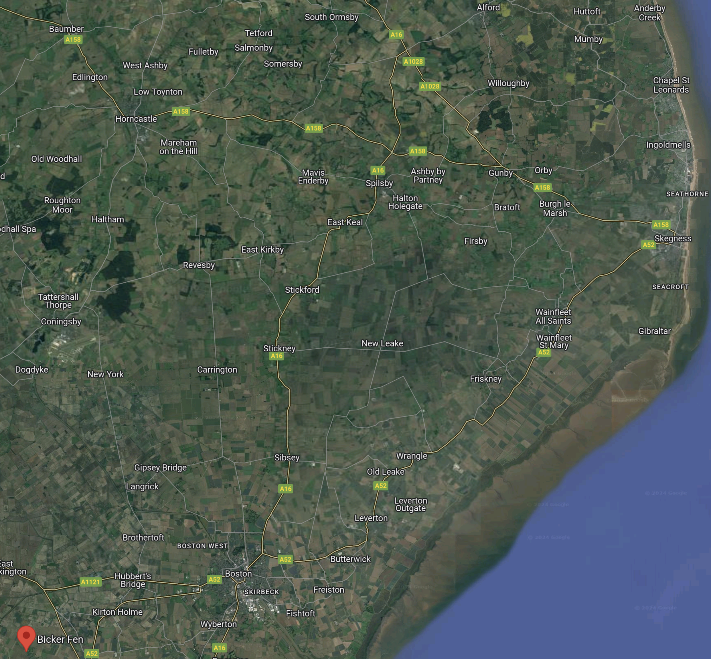
This Google Map shows Bicker Fen and Anderby Creek.
Note.
- Bicker Fen substation is in the South-West corner of the map and is indicated by a red arrow.
- Anderby Creek is in the North-East corner of the map.
- The cable is underground.
- This page on the Murphy Group website, describes the work the company did to install the cables.
- It appears from the Murphy document, that there are six cables between Anderby Creek and Bicker Fen.
This Google Map shows Anderby Creek.
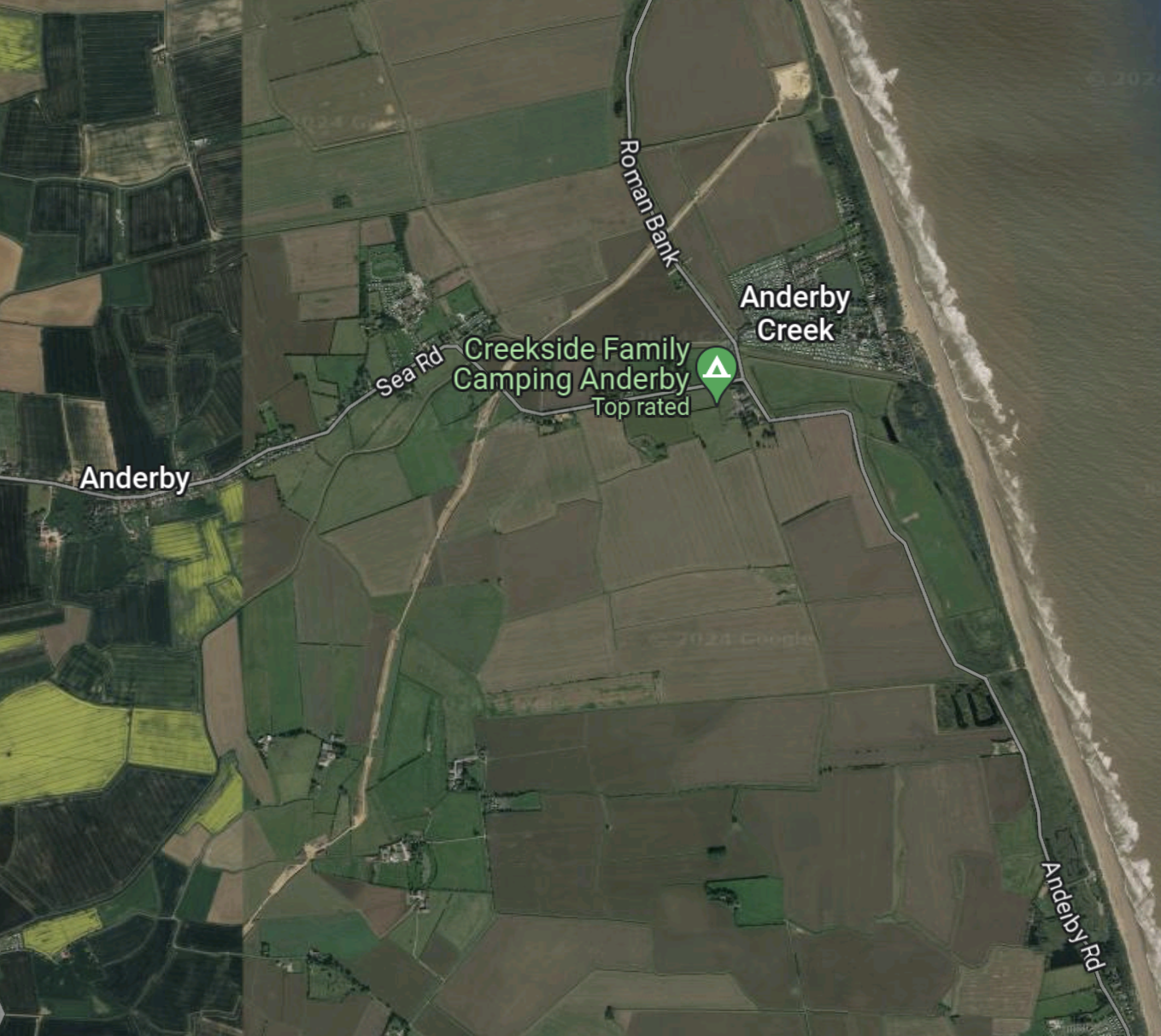
Could the scar across the land to the West of Anderby Creek, be the connection to the offshore Triton Knoll wind farm?
I think it is! And I also think that it can carry more than just the 857 MW Triton Knoll wind farm!
I am suspicious, that one of Baldrick’s ancestors has been at work and the Triton Knoll export cable system could be used to connect Green Link 3 and Green Link 4 to Bicker Fen and Walpole substations.
This would surely allow Scottish wind power to be sold to Denmark and then sold onward to Germany.
The VikingCCS Project
The VikingCCS project is a carbon capture and storage project, that is proposed to be based at the decommissioned Theddlethorpe gas terminal.
The VikingCCS project has a web site.
Would the use of the Theddlethorpe gas terminal mean that it is more likely that Green Link 3 and Green Link 4 will make a Southern landfall at Anderby Creek?
Will There Be A Connection To Viking Link?
The Viking Link is a 1400 MW at 525 KV electricity interconnector between Bicker Fen in Lincolnshire and Revsing in Jutland, Denmark.
This Google Map, shows the location of Bicker Fen, about halfway between Boston and Sleaford.

This second map shows the position of the current Walpole substation with respect to the Wash.
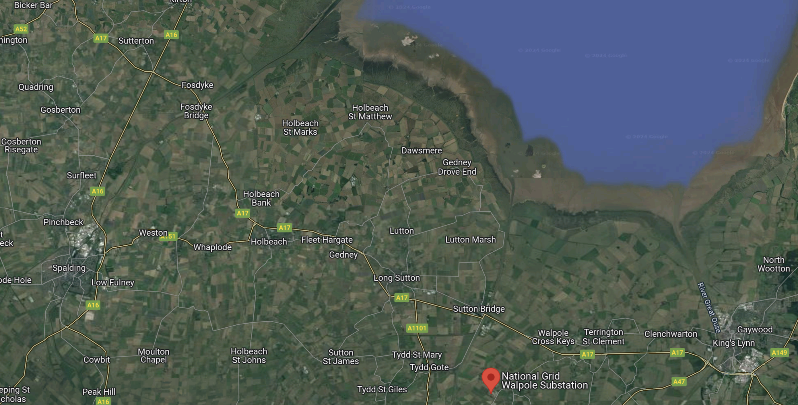
Note.
- Bicker Fen is in the North-West corner of the map.
- The current Walpole substation is marked by the red arrow.
- King’s Lynn is in the South-East corner of the map.
I suspect, if National Grid wanted to connect Green Link 3 and Green Link 4 to the Viking Link, then this would be possible.
If the Viking Link were to be connected to Green Link 3 and Green Link 4, this would allow surplus Scottish renewable energy to be sent to Denmark and on to Germany.
Green Link 3, Green Link 4 And Viking Link Appear To Be Underground In Lincolnshire
I can’t find any trace of overhead cables for the Viking Line in Lincolnshire and the press release says this about Green Link 3 and Green Link 4.
After making landfall, both projects’ cables will run underground for approximately 100km to two proposed converter stations in the Walpole, King’s Lynn and West Norfolk, area.
The connection to the Triton Knoll wuind farm is also underground.
It does appear that National Grid, are going for a Nimby-friendly approach for cables between Walpole and the coast.
Hopefully putting the cables underground will save money in legal arguments and fees.

I always would prefer to see hv cables buried but what happened toNational Grid’s arguement that it costs 10x more to bury a cable, rather than to run it on pylons
Comment by fammorris | April 29, 2024 |
This press release from National Grid talks about the start of construction of the Viking Link.
https://www.viking-link.com/news/national-grid-starts-construction-on-viking-link/
It offers no clues, but the Viking Link was built by Siemens using from the picture a large digger.
It also looks like an access road has been built from Bicker Fen to the coast, with the cable alongside the road.
It was built across good-class agricultural land with few features on the landscape.
So I just wonder, whether contractors found it an easy construction project.
I wonder, if based on the Viking Link experience National Grid feel that the cost of burying it can be covered by the projects.
I also suspect that as the Viking Link will be two-way, that it can generate more money so they could afford to bury it.
And what the contractors learned can be applied to the other two links, which probably share a route across Lincolnshire.
Comment by AnonW | April 29, 2024 |
[…] National Grid Shares Proposals For Green Electricity Projects In Lincolnshire And West Norfolk, Need…, I describe National Grid’s projects in the East of […]
Pingback by Where’s The Plan, Rishi? « The Anonymous Widower | June 20, 2024 |