The Garden At 120 – 27th September 2025
The Wikipedia entry for Fen Court has this section, which has a brief description of The Garden At 120.
In 2019, a mixed use building of 15 storeys built by Generali Real Estate with Eric Parry Architects, called One Fen Court or 120 Fenchurch Street, opened alongside the east side of Fen Court. The building has a publicly accessible roof garden named The Garden at 120, and is 69 metres (226 ft) high. A pedestrian route parallel to Fen Court runs through an undercroft in One Fen Court, with a ceiling-mounted public artwork.
As the helpful man on the entrance to the Garden at 120, said that I could see the tower of All Hallows Staining, I went back today and took these pictures.


Note.
- The Shard, Guerkin and Walkie-Talkie can be easily identified.
- Canary Wharf, St. Paul’s Cathedral and the River Thames can be seen in the distance.
- Pictures 16-21 give views of the tower of All Hallows Staining.
I shall be taking more pictures as Fifty Fenchurch Street grows.
Gwynt Glas And South Wales Ports Combine Strength In Preparation For Multi-Billion Floating Wind Industry
The title of this post, is the same as that of this news item from the Gwynt Glas wind farm.
The news item starts with a spectacular image of a port, that is assembling floating wind turbines and these three paragraphs.
Gwynt Glas Offshore Wind Farm has signed a Memorandum of Understanding (MoU) with the UK’s largest port operator, Associated British Ports, and Wales’ largest energy port, the Port of Milford Haven, to ready the ports for the future needs of floating offshore wind in the Celtic Sea.
Gwynt Glas is a joint venture partnership between EDF Renewables UK and DP Energy. The proposed floating offshore wind farm would generate 1GW of low carbon green energy in the Celtic Sea.
Under the MoU, information and industry knowledge will be shared to investigate the potential opportunities for manufacture, assembly, load-out and servicing for the Gwynt Glas project from the key South Wales Ports of Port Talbot and Milford Haven. This collaborative approach demonstrates a major commitment to supporting economic growth, investment and maximising social value in the region.
UK Port Unveils GBP 150 Million Offshore Wind Expansion Plan
The title of this post, is the same as that of this article on offshoreWIND.biz.
This is the sub-heading.
The Port of Tyne, located in the northeast of England, has unveiled its plans to add 400 metres of deep-water quayside to support offshore renewables, clean energy, and advanced manufacturing.
These two paragraphs add details.
The Port of Tyne is investing GBP 150 million (approximately EUR 173 million) to transform 230 acres into the Tyne Clean Energy Park, a move that could create up to 12,000 jobs, deliver GBP 5.6 billion (about EUR 6.5 billion) to the economy, and establish the North East as a hub for the UK’s green energy revolution, according to an independent study by WSP.
The plan for Tyne Clean Energy Park includes a kilometre of both new and redeveloped deep-water, heavy-lift quay to facilitate the use of a 230-acre footprint located within an Industrial Strategy Zone.
The Wikipedia entry for the Port of Tyne has this opening paragraph.
The Port of Tyne comprises the commercial docks on and around the River Tyne in Tyne and Wear in the northeast of England.
This Google Map shows the River Tyne Through Newcastle.
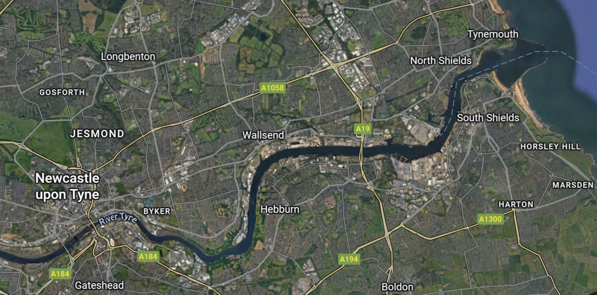
I estimate that this map is around twenty kilometres from East to West.
This news item from the Port of Tyne is entitled Port of Tyne Unviels 230 Acre Green Development Terminal and gives full details.
This summary is given.
The Port of Tyne is investing £150 million to transform 230 acres into the Tyne Clean Energy Park, adding 400 metres of deep-water quayside to support offshore renewables, clean energy, and advanced manufacturing. The redevelopment could create up to 12,000 jobs, deliver £5.6 billion to the economy, and establish the North East as a hub for the UK’s green energy revolution.
This is not a small development.
In future I shall tag developments like this with a tag of UK Port Development.
.
Yarmouth Harbour To Be ‘Completed’ In £60m Project
The title of this post, is the same as that of this article on the BBC.
This is the sub-heading.
A major port is set to expand to prepare for construction work linked to several national infrastructure projects.
These first two paragraphs, which give more details.
Peel Ports said it would invest between £50m and £60m in Great Yarmouth’s Outer Harbour by developing the southern terminal, creating a roll-on roll-off (RORO) lift ramp and a large storage area.
Port director Richard Goffin said the construction work, which is set to begin in 2026, would “complete” the port as laid out in a business case in the early 2000s.
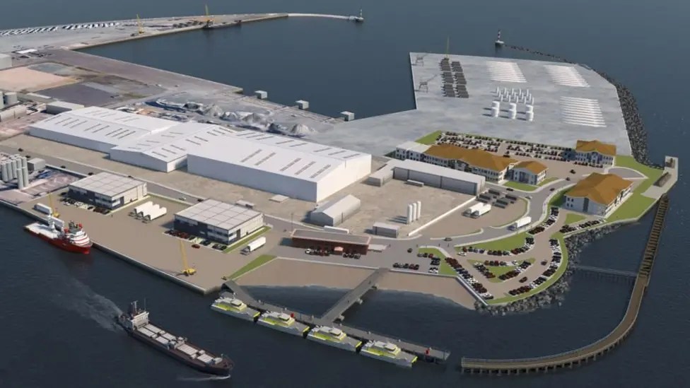
This image from Peel Ports Group shows how the Port of Great Yarmouth will look after the the proposed development.
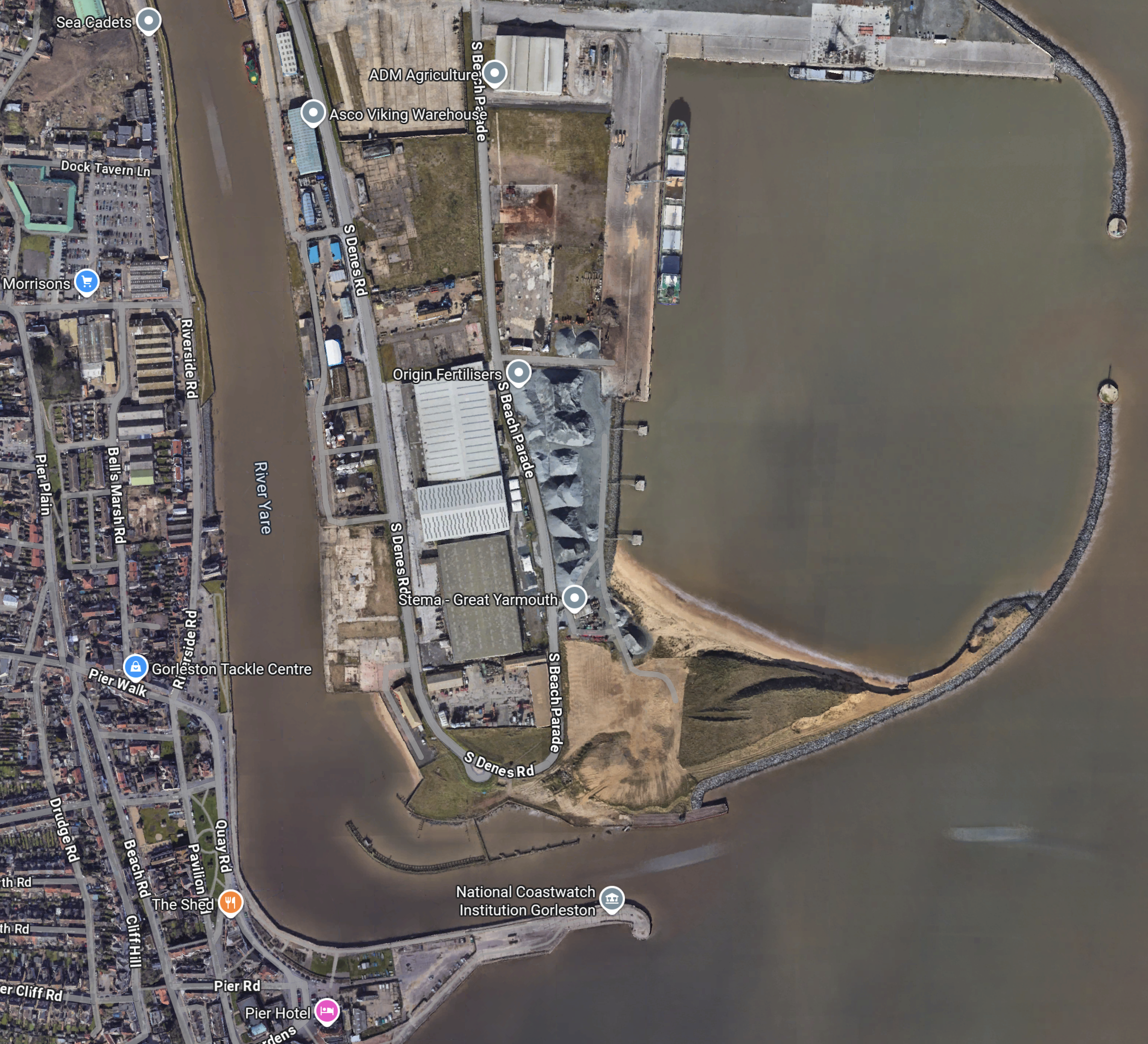
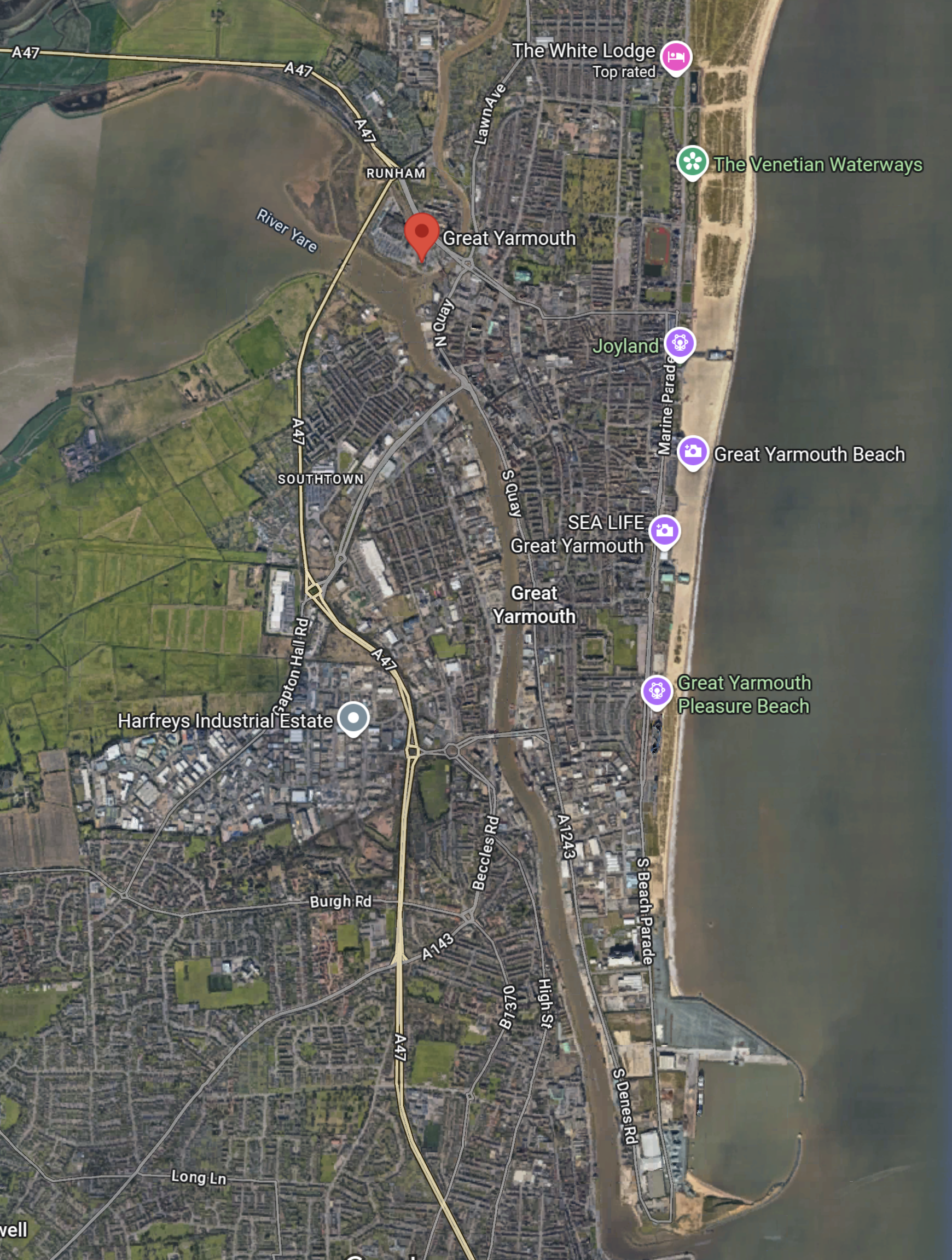
And this Google Map shows the port as it is today.
Note.
- The large triple shed, with the cross-wise middle section can be picked out in both the image and the map.
- The label by the shed says Origin Fertilisers, so I suspect the three objects on the quayside, which are visible in both the image and the map could be conveyors for loading and unloading ships with fertiliser.
- The two breakwaters are visible in both the image and the map.
It looks like the development would mainly involve filling in the Southern part of the current harbour.
With only a quick look and scant details, it looks to me, that it is a development that could be easily realised.
I have some thoughts.
Rail Access To The Port
There is no rail access to the port and I couldn’t see how it could be provided, without demolishing half of the town.
But there are carriage sidings at Great Yarmouth station, which are described in this Wikipedia entry like this.
New sidings were provided at the western end of the station to cope with the additional services operating into the station, following the closure of the M&GN system. It is a crescent-shaped site between the A47 road and Wherryman’s Way at the northernmost point of the River Yare, about 1⁄4 mi (400 m) north-west of the station. It had fallen out of use in the 1980s when Norwich Crown Point depot was built.
In 2010, the unused sidings were purchased by Great Yarmouth Borough Council; they were intended for use as a freight terminal, despite the lack of rail connection to the town’s port. It was hoped that 10,000 tonnes of sugar cane per week would be carried from Yarmouth to Cantley. The need to use a lorry shuttle between the docks and the rail yard, along with a £3.2 million quote for replacing the sidings at Cantley, saw the plan dropped.[19]
In May 2020, Eastern Rail Services commenced a lease with Norfolk County Council and Network Rail for Yarmouth Vauxhall sidings. Managing director James Steward said the siding “matched ERS’s requirement for an East Anglian site to base its rolling stock.” Following extensive de-vegetation works, Direct Rail Services 37402 became the first locomotive in 19 years to run into the sidings on 26 May 2020, followed the next day by it delivering five former Greater Anglia Mark 3 coaches for storage. On 6 July 2020, ERS was authorised a licence exemption permitting them to operate trains within the site
The Port of Great Yarmouth appears to be keen to do its part in the construction of Sizewell C. Could components for the power station, be brought into the port through the new roll-on/roll-off berth and then transferred to rail in the former carriage sidings?
This 3D Google Map shows the carriage sidings.
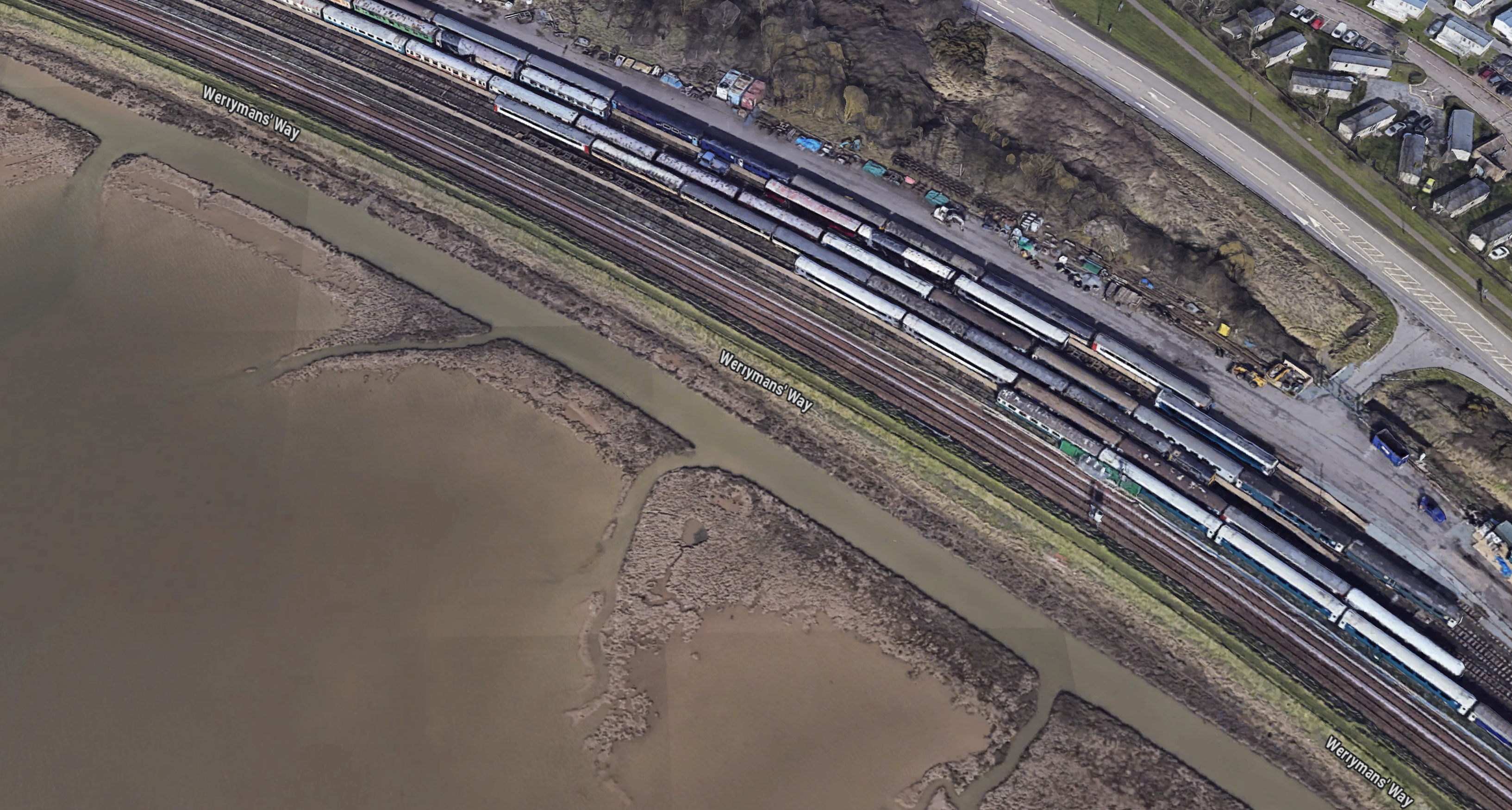
Most of the rolling stock appears to be retired Mark 2 and M3 coaches.
Road Access To The Port
This Google Map shows Great Yarmouth and the Port and roads in the area.
Note.
- The red arrow indicates Great Yarmouth station.
- The Port of Great Yarmouth is in the South-East corner of the map.
- The A 47 runs down the West side of the town.
- The River Yare runs from the railway station to the sea, just below the port.
There is a road on the East bank of the River Yare, that connects to the A 47 and could easily connect to a rail cargo terminal to the North-West of the station in the derelict carriage sidings.
I can certainly see Nimbies not liking the new roll-on/roll-off ferry creating traffic in the town.
The Construction Of Sizewell C
Sizewell C is very similar to Hinckley Point C and this extract from the Wikipedia entry for Hinckley Point C describes some of that power station’s construction.
In March 2017, EDF, after the Office for Nuclear Regulation (ONR) gave approval to start building, the building of the first parts of the plant proper began with a network of tunnels to carry cabling and piping. Work was also under way on a jetty to land building materials, a seawall, and accommodation blocks.
In January 2018, EDF said that they were on track to start generating electricity by 2025 and that they planned to start constructing above-ground structures for the power station by June 2019.
The approximate 2,000 cubic metres (71,000 cu ft) concrete pour for the first reactor started on 11 December 2018. It was completed over a 30-hour period, creating the first part of the unit one 4,500 tonne base, a platform 3.2 metres (10 ft 6 in) thick. The reactor building will be built on the (to be completed) platform. This construction start marks the first new reactor build in the UK after a 30-year break, and the second PWR in the UK, after Sizewell B.
Completion of the base for the first reactor, the final 8,954 cubic metres (316,200 cu ft) of concrete, was achieved in June 2019. Completion of the base for the second reactor, 8,991 cubic metres (317,500 cu ft) of concrete, was achieved in June 2020.
Construction utilises the world’s largest crane, the Sarens SGC-250 double ring crane, which is responsible for lifting Hinkley Point C’s heaviest components. More than 600 heavy fabrications, including the five major parts of each unit’s steel containment liner and dome, are positioned by the SGC-250. The crane, named Big Carl, was delivered in modular form, consisting of over 400 deliveries.
In February 2023, the first nuclear reactor pressure vessel was delivered to site via the Bristol Channel Hinkley-dedicated wharf at Combwich. The pressure vessel was built in France in 2022 by Framatome.
In May 2024, the first of the 520 tonne steam generators was delivered to site in the same manner as the reactor pressure vessel.
Note.
- A good proportion of the power station and the materials to build it were brought in by sea.
- The size of everything is huge.
- Big Carl seems to make appearances in all big projects.
- According to the BBC, Peel Ports are spending £60million on a new roll-on/roll-off terminal, 350 metres of quay and ten hectares of high quality storage space.
I wouldn’t be surprised, if they have the contract for Sizewell C’s logistics, that Peel Ports will be laughing all the way to the bank.
If nothing else, after Sizewell C is completed, they will have a high-class port facility at the end of the A 47 from Birmingham, Leicester, Peterborough and Norwich, which could open up possible ferry routes to Europe.
Between Great Yarmouth And Sizewell
If the components come in to Great Yarmouth on trailers on the RORO ferries from France, they could be taken to Sizewell on the A 12 road.
Smaller components may be taken by road, but I wouldn’t rule out a transfer to rail in the carriage sidings at Great Yarmough, as I indicated earlier.
RWE Opens ‘Grimsby Hub’ For Offshore Wind Operations And Maintenance
The title of this post, is the same as that of this article on offshoreWIND.biz.
This is the sub-heading.
RWE officially opened its ‘Grimsby Hub’ offshore wind operations and maintenance (O&M) facility in the UK on 9 July. From the new O&M base, located at Associated British Ports’ (ABP) Port of Grimsby, RWE’s teams will maintain and operate the Triton Knoll and Sofia offshore wind farms.
These are the first two paragraphs.
The Grimsby Hub also houses RWE’s new UK Centralised Control Room (CCR), which has been set up to provide 24/7 monitoring of the company’s UK offshore wind farms and can provide services such as marine coordination, turbine operations, alarm management, high voltage monitoring and Emergency Response services with a team of twelve operatives, the developer says.
The O&M facility is already employing over 90 Full-Time Equivalents (FTEs), according to RWE, and is expected to employ around 140 RWE staff by 2027, as well as create approximately 60 new locally sourced jobs through the development of the CCR and ongoing offshore operations.
Note.
- Does RWE’s new UK Centralised Control Room control all their UK offshore wind farms?
- I have added them all up and there are almost 12 GW around our shores.
- I’ve read somewhere, that RWE are the UK’s largest power generator. From these figures, that would not surprise me.
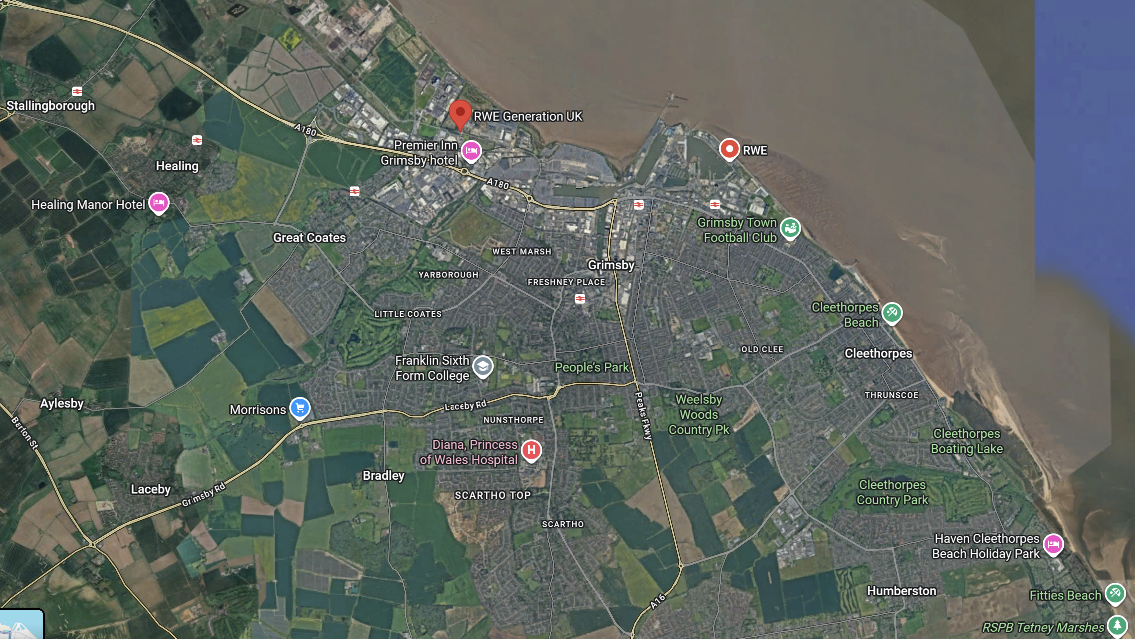
This Google Map shows the location of RWE’s facilities in Grimsby.
Note.
- The bright red arrow at the top of the map indicates RWE Generation UK in Grimsby Docks.
- There is another RWE location to the right of the bright red arrow.
- There is a line of stations along the coast, which from left-to-right are Stallingborough, Healing, Great Coates, Grimsby Town, Grimsby Docks, New Clee and Cleethorpes.
- Cleethorpes is not shown on the map.
- Doncaster and Cleethorpes are 52.1 mile apart, which is within the range of a battery-electric Hitachi and other trains.
- Charging would be at Doncaster, which is fully electrified and at Cleethorpes, by a short length of electrification.
This OpenRailwayMap shows the layout of and the railways around Grimsby Dock.

Note.
- Cleethorpes station is indicated by the blue arrow, in the South-East corner of the map.
- Cleethorpes station has four platforms, but no electrification.
- Grimsby Docks are to the North of the railway to Cleethorpes.
- This Wikipedia entry for Cleethorpes station, shows other railways and light railways served the area. Some were even electric.
These are a few of my thoughts on the development of railways between Sheffield and Cleethorpes.
RWE Will Be A Large Driver Of Employment In Grimsby
Earlier I wrote.
- Does RWE’s new UK Centralised Control Room control all their UK offshore wind farms?
- I have added them all up and there are almost 12 GW around our shores.
- I’ve read somewhere, that RWE are the UK’s largest power generator. From these figures, that would not surprise me.
It’s a long time, since I’ve added resources to a large project, so I asked Google AI, “How many people are needed to support a 1 GW offshore wind farm in the UK?”, and received this answer.
Direct & Indirect Support: For a large-scale project, this often breaks down into approximately 100–150 direct, permanent, high-skilled roles (technicians, engineers, management) and hundreds more in indirect, contracted, or supply chain roles (vessel crews, port operations, logistics).
Industry Average: Studies suggest that for operations and maintenance (O&M), around 50–100 full-time equivalent (FTE) jobs are generated per GW of installed capacity in terms of direct, permanent staff.
Key Takeaways for a 1 GW Farm:
- Direct Technicians/Operators: ~100–200+ (working on-site, turbines, or in control rooms).
- O&M Support Services: ~300–400+ (vessel operators, port logistics, supply chain).
- Total Operations Personnel: 300–600+ people.
Google AI appeared to have borrowed the figure from Ørsted and Hornsea 1 and 2.
So if it’s correct, there will be a total of 7,200 personnel supporting RWE’s wind farms in the UK. Even if only a third were employed in Grimsby, that is still a lot of people to accommodate and who will need to travel to work.
I also think a lot of personnel will come in by train, as the station is close to RWE’s locations.
Will Grimsby Have An Aberdeen-Sized Office-Shortage Problem?
One of the biggest problems, I was always hearing in the 1970s, was the shortage of offices in Aberdeen for the use of the oilmen.
In RWE Goes For An Additional 10 GW Of Offshore Wind In UK Waters In 2030, I talked about RWE’s plans for the future and published this table of new wind farms.
- Sofia – 1,400 MW
- Norfolk Boreas – 1380 MW
- Norfolk Vanguard East – 1380 MW
- Norfolk Vanguard West – 1380 MW
- Dogger Bank South – 3000 MW
- Awel y Môr – 500 MW
- Five Estuaries – 353 MW
- North Falls – 504 MW
Note.
- Sofia is nearly complete.
- Only the three Norfolk and the Dogger Bank South wind farms are on the East side of England and suitable to be serviced from Grimsby., but they still total 7,140 MW.
Has Grimsby got the office-space for all the people needed?
Could The Cleethorpes And Liverpool Lime Street Service Be Run By Battery-Electric Rolling Stock?
The various sections of this route are as follows.
- Cleethorpes and Doncaster – No Electrification – 52.1 miles
- Doncaster and Meadowhall – No Electrification – 15.2 miles
- Meadowhall and Sheffield – No Electrification – 3.4 miles
- Sheffield and Dore & Totley – No Electrification – 4.2 miles
- Dore & Totley and Hazel Grove – No Electrification – 29.2 miles
- Hazel Grove and Stockport – Electrification – 3.3 miles
- Stockport and Manchester Piccadilly – Electrification – 5.9 miles
- Manchester Piccadilly and Deansgate – Electrification – 0.8 miles
- Deansgate and Liverpool South Parkway -Not Electrified – 28.2 miles
- Liverpool South Parkway and Liverpool Lime Street – Electrified – 5.7 miles
Adding the sections together gives.
- Cleethorpes and Hazel Grove – No Electrification – 104.1 miles
- Hazel Grove and Deansgate – Electrification – 10 miles
- Deansgate and Liverpool South Parkway -Not Electrified – 28.2 miles
- Liverpool South Parkway and Liverpool Lime Street – Electrified – 5.7 miles
Note.
- To cover the 104.1 miles to Hazel Grove battery-electric trains would probably need to leave Cleethorpes with full batteries.
- Doncaster is a fully-electrified station and passing trains may be able to have a quick top-up.
- In South Yorkshire Now Has Better North-South Connections, I calculated that Doncaster is a very busy station with 173 express trains per day calling at the station or one every 8.5 minutes.
- Will trains be able to stop for a long period to charge batteries?
- It may be prudent to electrify between Meadowhall and Sheffield, under the Midland Mainline Electrification.
- Sheffield and Dore & Totley is shown that it will be electrified, under the Midland Mainline Electrification.
- Do we really want to have electrification marching along the Hope Valley Line?
- I believe that hydrogen-hybrid locomotives will be a better solution for freight trains on scenic lines like the Hope Valley, as they are zero-carbon, powerful and with a range comparable to diesel.
I believe CAF, Hitachi and Siemens have off the shelf rolling stock and factories in this country, who could build trains for the Cleethorpes and Liverpool Lime Street route.
How Would You Charge Battery-Electric Trains At Cleethorpes?
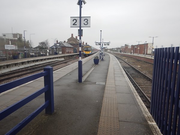
This picture shows Cleethorpes station
Note.
- The four long platforms without electrification.
- The platforms have recently been refurbished.
- The train in Platform 2 is a TransPennine Express Class 185 Siemens Desiro diesel train.
The simplest way to electrify the station would be to put up enough 25 KVAC overhead wires, so that battery-electric trains needing a charge could put up a pantograph and have a refreshing drink.
In Technology Behind Siemens Mobility’s British Battery Trains Hits The Tracks, I wrote about Siemens Rail Charging Converter.
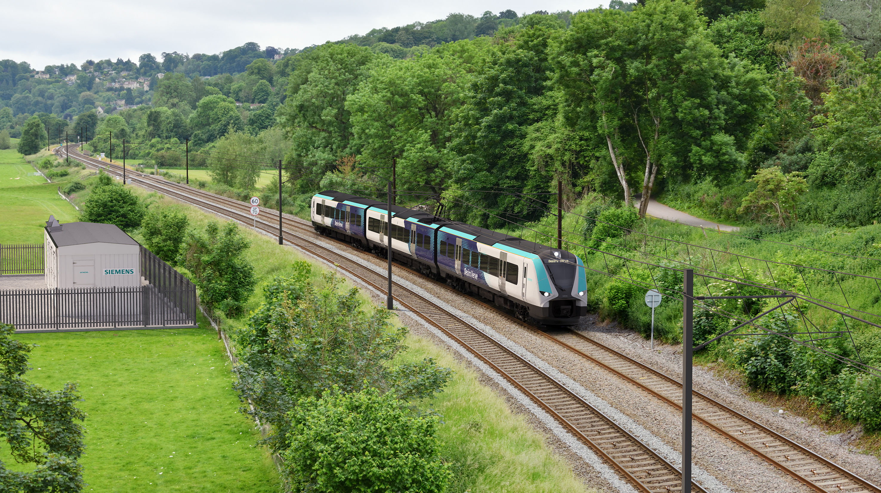
This is a visualisation of a Siemens Rail Charging Converter in action.
Note.
- The track is electrified with standard 25 KVAC overhead electrification.
- The train is a standard Siemens electric or battery-electric train.
- Siemens Rail Charging Converter, which is the shed in the compound on the left is providing the electricity to energise the catenary.
- I suspect, it could power third rail electrification, if the Office of Rail and Road ever allowed it to be still installed.
- The Siemens Rail Charging Converter does have one piece of magic in the shed. I suspect it uses a battery or a large capacitor to help power the electrification, as it can be powered from any typical domestic grid supply.
- I also wonder, if it has safety devices that cut the power outside the shed if track workers or intruders are detected, where they shouldn’t be?
- It could even cut the power, when trains are not running to save power and increase safety.
This looks to me, that a Siemens Rail Charging Converter could be a superb example of out-of-the-box thinking.
Could The Cleethorpes And Barton-on-Humber Service Be Run By Battery-Electric Rolling Stock?
This OpenRailwayMap shows the railways of North-East Lincolnshire.
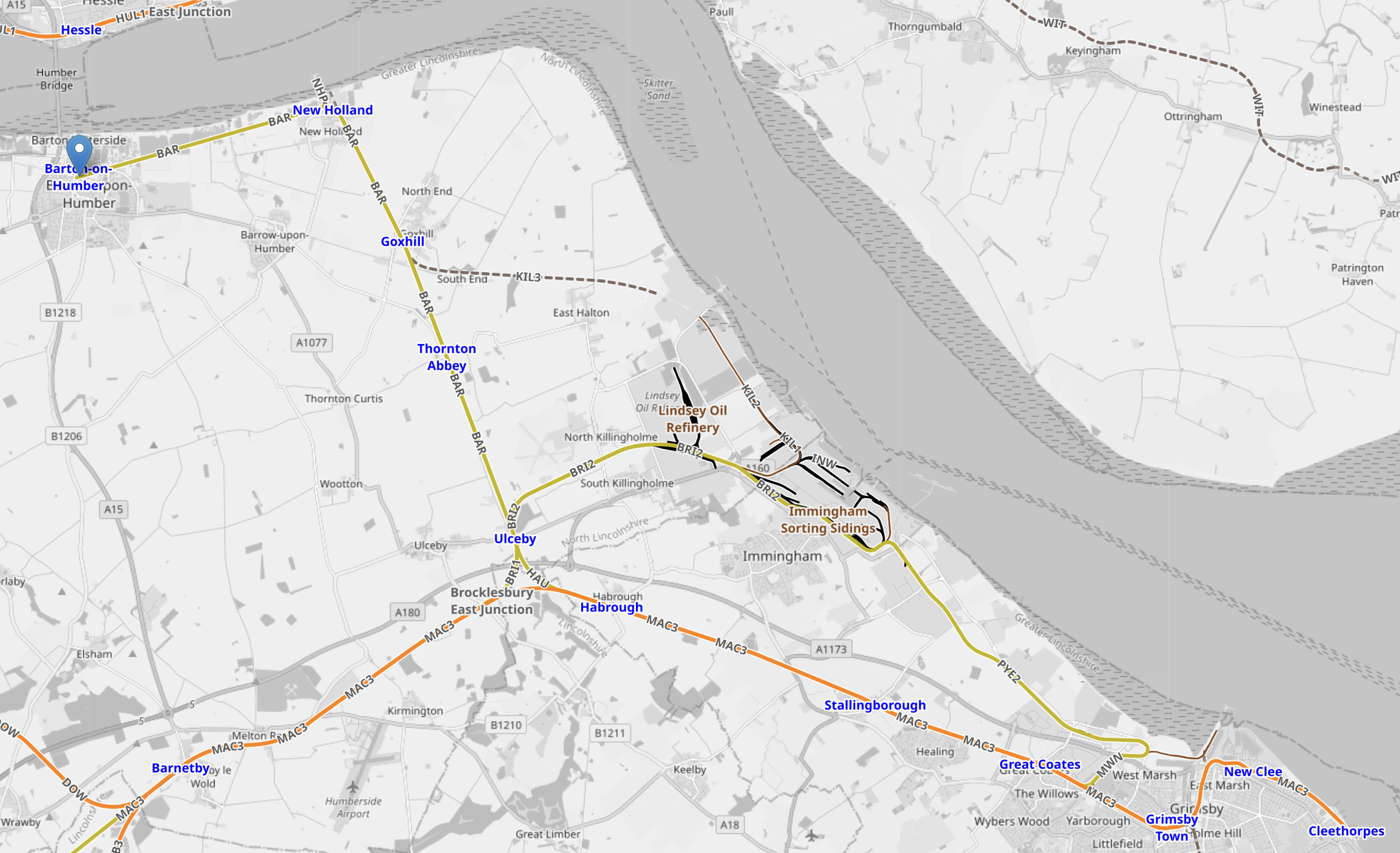
Note.
- Cleethorpes is in the South-East Corner of the map.
- Barton-on-Humber is in the North-West corner of the map and marked by a blue-arrow.
- Stations from South to North would be New Clee, Grimsby Docks, Grimsby Town, Great Coates, Healing, Stallingborough, Habrough, Ulceby, Thornton Abbey, Goxhill, New Holland and Barrow Haven.
- The line is double track.
- Cleethorpes and Barton-on-Humber is just 22.8 miles.
- A round trip would be under fifty miles, which would be well within range of a full-charge at one end.
- Service is one train per two hours (tp2h), which would only need a single train, shuttling between Cleethorpes and Barton-on-Humber.
- Two trains could provide an hourly service.
I would expect, that well-designed, solid and reliable German engineering could build a Siemens’ Rail Charging Connector that could charge four trains per hour (tph) at Cleethorpes station.
At present services are.
- TransPennineExpress – 1 tph to Liverpool Lime Street.
- East Midlands Railway – 1 tp2h to Barton-on-Humber
- East Midlands Railway – 1 tp2h to Matlock via Lincoln and Nottingham
- Northern Trains – 1 train per day (tpd) Sheffield via Brigg.
That is probably only about two tph.
Could The Cleethorpes And Sheffield Service Be Run By Battery-Electric Rolling Stock?
This is a description of the current Cleethorpes and Sheffield service.
- It is run by Northern Trains.
- The morning train leaves Sheffield at 09:54 and arrives in Cleethorpes at 11:40.
- The afternoon train leaves Cleethorpes at 13:20 and arrives in Sheffield at 15:10.
- The train is a Class 150 diesel train, which is a bit of a Joan Collins of a train – Of a certain age, but still scrubs up extremely well!
- Intermediate stations are Worksop, Retford, Gainsborough Central, Kirton Lindsey, Brigg, Barnetby and Grimsby Town
- The route length is 71.6 miles
- Trains take about 45-50 minutes.
It is also a parliamentary train.
The Wikipedia entry for parliamentary train gives this description of the Cleethorpes and Sheffield service.
Via Kirton Lindsey & Brigg. Became a parliamentary service when weekday services were withdrawn in 1993. Regular trains have operated between Gainsborough and Sheffield for most timetable periods since. Suspended January 2022 by Northern, who cited COVID-19 and staffing issues , but the service was reinstated in December 2022. Changed in May 2023 to be one return journey on weekdays only.
In the 1950s and 1960s I lived in Felixstowe part of the time and in the 1970s and 1980s I lived near Woodbridge and I observed first hand the development of the Port of Felixstowe and the effects it had on the surrounding countryside.
The development of the Port of Felixstowe, has brought the following.
- Improved roads and railways.
- Ipswich is now an hour from London by train.
- Ipswich is now a University town.
- New housing and other developments, both in Ipswich and Felixstowe and the surrounding countryside.
- Employment also has increased considerably, both in the Port and in surrounding towns.
- Ipswich’s football team is very much respected all over Europe and has won the English top division, the FA Cup and the UEFA Cup.
When you consider the jobs that RWE could create in the Port of Grimsby, I believe that this could have similar effects in Grimsby and Cleethorpes, as the Port of Felixstowe had in East Suffolk.
Already, the following are being talked about.
- A direct rail link between Cleethorpes and Grimsby to London.
- Battery-electric trains between Cleethorpes and Grimsby and Doncaster, Manchester and Liverpool Lime Street.
I believe that an improved rail link between Cleethorpes and Sheffield could be the catalyst for much needed housing along the route, which would be to the benefit of Cleethorpres, Grimsby, Sheffield and all the intermediate towns and villages on the route.
and the affects this will have on the countryside around the town, I believe that a strong case can be made out for a more frequent service between Cleethorpes and Sheffield.
North East Coast Named Top UK Rail Walking Route Thanks To Northumberland Line Reopening
The title of this post, is the same as that of this article on the Northumberland Gazette.
This is the sub-heading.
A once-missing link in Northumberland’s rail network has helped unlock a new coastal walking route.
These two introductory paragraphs add more detail.
Railwalks.co.uk, a national group which aims to promote walking from railway stations, has identified the North East coastline as one of the best-served by rail in Britain.
This has only become possible since the reopening of Ashington Station last year. Until July 19, Railwalks.co.uk founder member Steve Melia will be walking 92 miles from Alnmouth to Seaton Carew, following the England Coast Path.
If people are walking the coast, they are going to need support like cafes, pubs and shops.
This OpenRailwayMap shows the Northumberland Line and the coast.
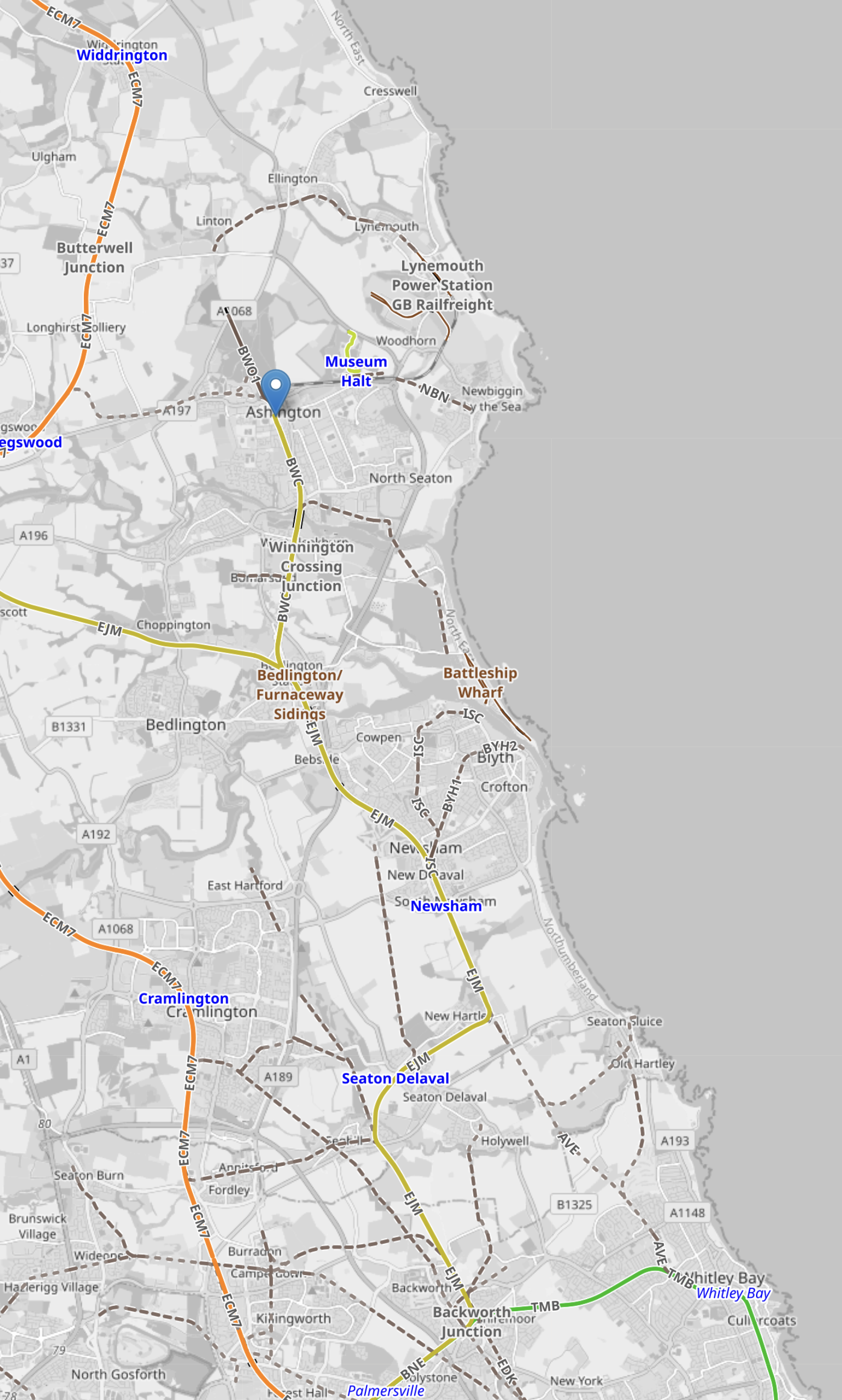
Note.
- The orange track is the East Coast Main Line with stations at Widdrington, Pegswood and Cramlington, as you come down the map.
- The blue arrow indicates Ashington, which is the terminus of the Northumberland Line.
- The yellow track is the Northumberland Line, which passes through Newsham and Seaton Delaval.
- The green track at the bottom of the map, is the Newcastle Metro to Whitley Bay, Tynemouth and North Shields.
- To the East of Ashington is Museum Halt, which could be a station on an extension of the railway to Newbiggin-by-the-Sea, which I wrote about in Onward To Newbiggin-by-the-Sea For The Northumberland Line?.
How many other places in the UK would benefit from a new or reopened railway for business, leisure and building houses in nice little inaccessible towns and places?
Permission Granted For Ayrshire Renewables Hub
The title of this post, is the same as that of this article on Scottish Construction Now.
This is the sub-heading.
Planning consent has been granted for a £150 million upgrade to an Ayrshire marine yard, paving the way for increased offshore wind power off the UK’s west coast.
These are the first three paragraphs.
Peel Ports Clydeport has secured permission for the complete redevelopment of the Hunterston marine yard as it prepares the site for major renewables infrastructure. The redevelopment works – which are expected to start in early 2025 and last for around two years – will include substantial upgrades to the marine yard, including infilling the current dry-dock basin and the creation of a new quay wall.
Highview Power recently announced it is to construct the world’s largest Liquid Air Energy Storage (LAES) facility at Hunterston, the latest in a string of renewables projects that are either underway, or in the pipeline, at the site.
The overall redevelopment of Hunterston is expected to attract £3.5 billion in inward investment and create over 5,000 jobs.
Note.
- The Highview Power battery will be 200 MW/3.25 GWh.
- There is also a 400 MW/400 MWh BESS being built at Hunterston.
- The 2 GW MacHairWind project is planned off the coast of Islay.
- According to their web site, MacHairWind will export its first power in the early 2030s.
More renewable infrastructure will surely follow.
Robertsbridge Station – 25th September 2024
I went to Robertsbridge station, today and took these pictures of the station.


Note.
The tracks are electrified.
- The platforms can accommodate eight-car trains and probably ten-car trains.
- There is a level-crossing at the South end of the station.
- The bridge is not step-free.
- Passengers may be able to use the level-crossing to cross the tracks
- The station has a good collection of books for passengers.
- The London trains are in good conditiopn.
- There is an adequate amount of car parking.
It is a small workmanlike country station typical of many in the UK.
This Google Map shows the station.
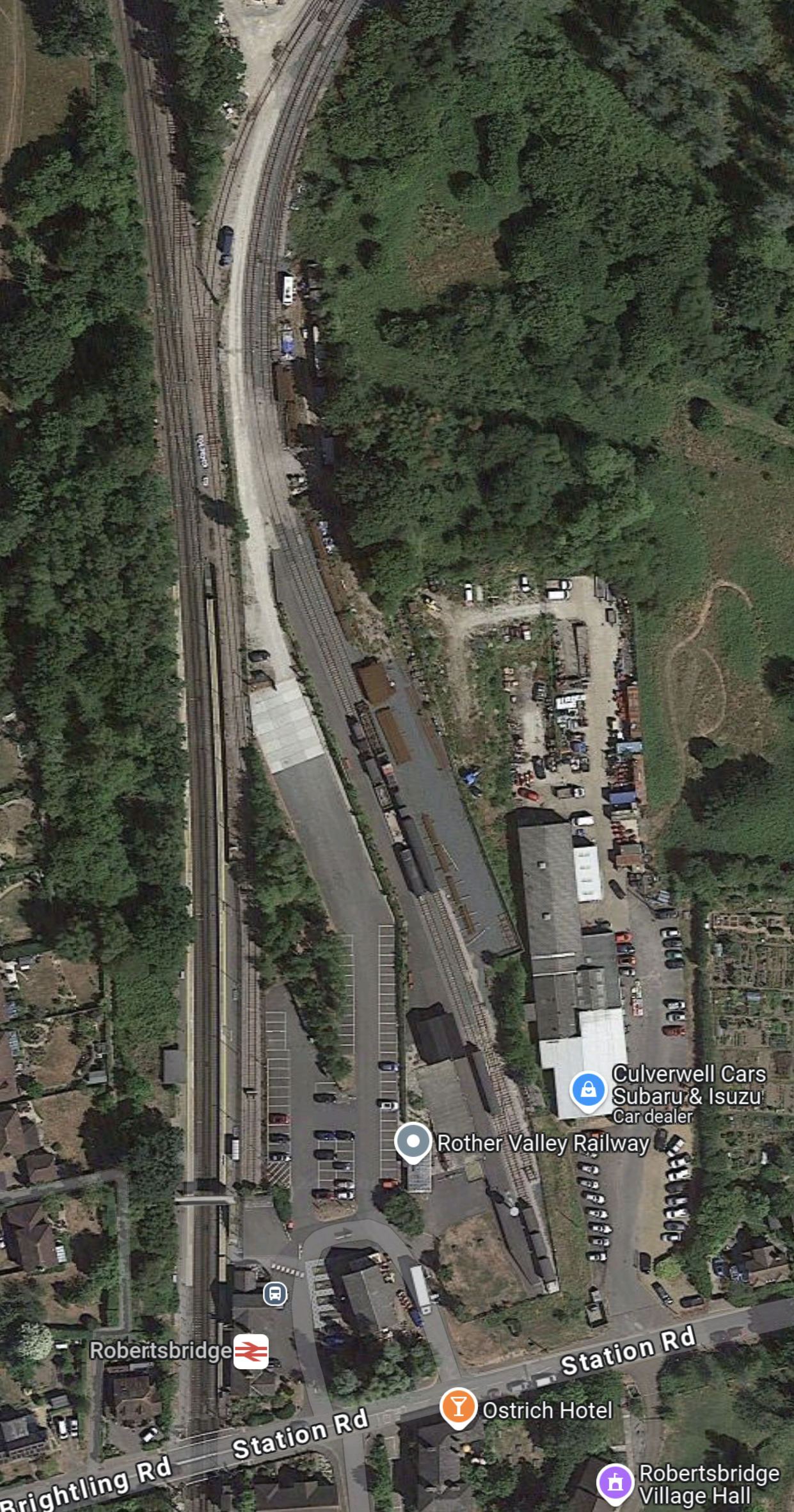
Note.
The London and Hastings Line runs down the West side of the map.
The station buildings are marked by the usual sign and are on the East side of the tracks.
Also on the East side of the tracks is a siding used by Network Rail to store machinery and a car park and then the premises of the Rother Valley Railway.
Station Road with its level crossing runs across the bottom of the map.
These are my thoughts.
The Aim Of The Rother Valley Railway
This is the first paragraph of the Wikipedia entry for the Rother Valley Railway.
The Rother Valley Railway (RVR) is a heritage railway project based at Robertsbridge in East Sussex, England. It takes its name from the original name for what later became the Kent and East Sussex Railway, running from Robertsbridge through to Headcorn in Kent, via Tenterden. The project is to replace the “missing link” between Robertsbridge, a station on the Tonbridge to Hastings mainline, and Bodiam on the Kent and East Sussex Railway, a heritage railway which operates from Bodiam to Tenterden.
This OpenRailwayMap shows the route of the railway between Robertsbridge and Tenterden Town.
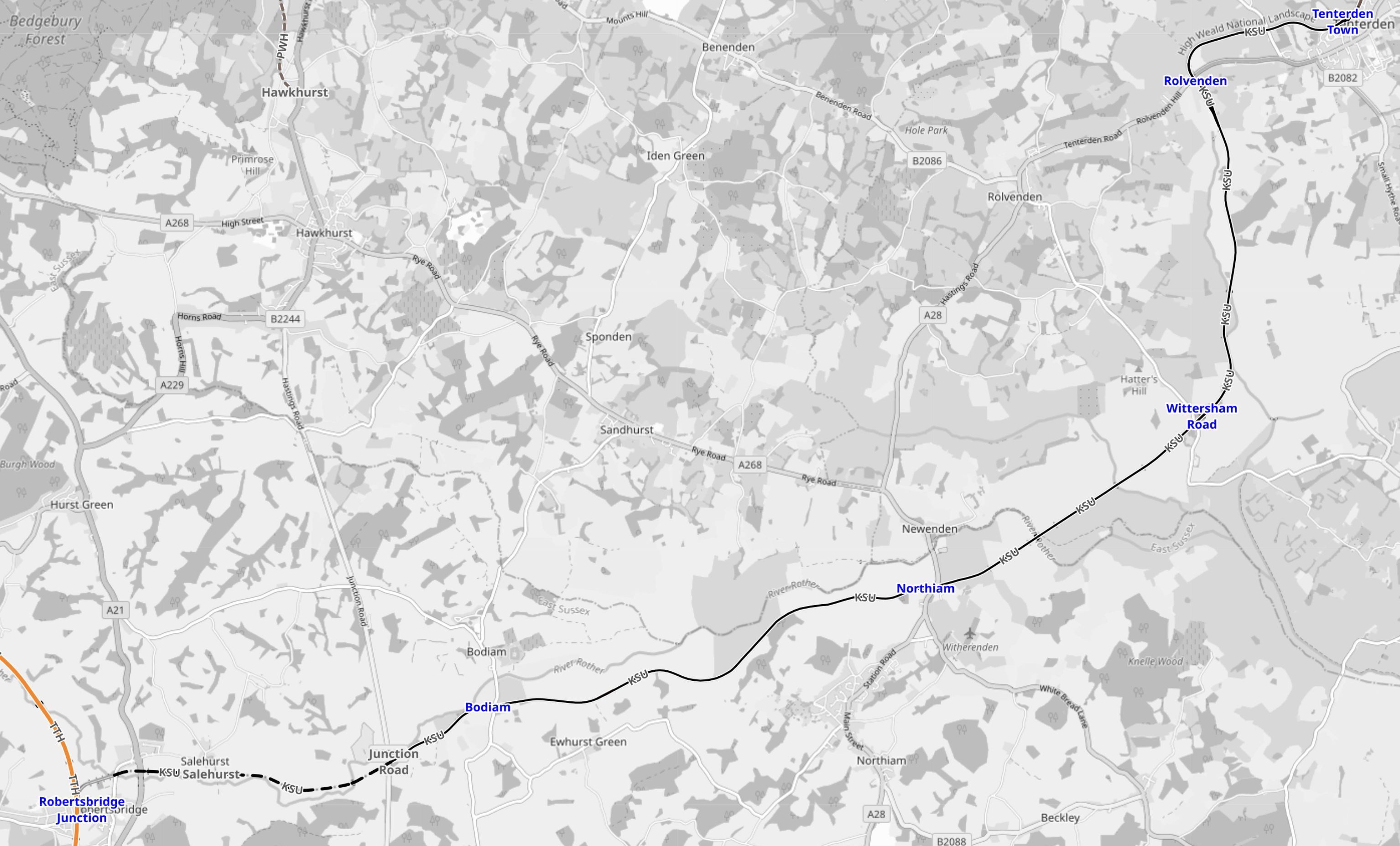
Note.
- Robertsbridge Junction is in the South-West corner of the map.
- Tenterten Town is in the North-East corner of the map.
- Bodiam, Northiam, Wittersham Road and Rolverden are the intermediate stops.
This second OpenRailwayMap shows the tracks at Rotherfield.
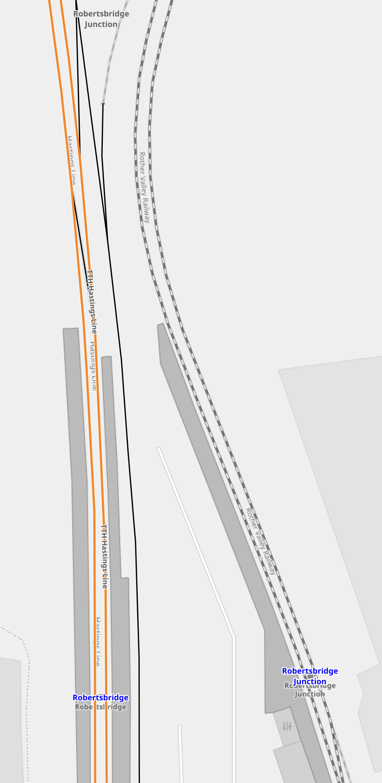
Note.
- Robertsbridge station is on the West.
- Robertsbridge Junction station of the Rother Valley Railway is on the East.
- Network Rail’s siding runs between the stations.
It appears that the Robertsbridge Junction station has a turnback for a locomotive.
Progress On The Rother Valley Railway
This is the second paragraph of the Wikipedia entry for the Rother Valley Railway.
Following a public inquiry in 2021, the government approved the project in May 2023 and granted the RVR’s application for a Transport and Works Act Order. This came into force on 2 August, allowing the reinstatement scheme to be completed. There will be then an end-on link with the Kent and East Sussex at Bodiam enabling through-running of passenger trains between Tenterden and Robertsbridge for the first time since 1954. Heritage trains will make use of the Rother Valley Railway’s own new station at Robertsbridge Junction, a short walk from the mainline station. Work is expected to begin on the final phase of reinstatement in 2024, following detailed surveys.
It certainly looks like progress is being made.
Tenterden Is The Largest Town In Kent Without A Railway Station
Although compared to some towns, that have recently got stations, it is somewhat smaller.
But it is larger than Okehampton, which has successfully opened a National Rail station.
Perhaps, a supermarket car park can be found big enough for a single platform station?
Starmer May Give Tenterden Some New Development
A few more houses could generate commuter traffic.
Will VAT On School Fees Encourage train Travel To School?
But train travel may be cheaper than a car to say Tonbridge by car! Every little helps!
More Trains At Robertsbridge Could Draw Traffic
Two trains per hour would surely help.
Conclusion
A Tenterden branch could be viable for a shuttle between Robertsbridge and Tenterden.
Two Ports Advance To Next Stage Of UK Gov Funding For Floating Wind
The title of this post, is the same as this article in Ground Engineering.
This is the sub-heading.
Port Talbot in Wales and Port of Cromarty Firth in Scotland have advanced to the next stage of a government funding scheme to develop port infrastructure that will facilitate floating offshore wind.
These three paragraphs introduce the developments.
The UK Government has agreed that the port expansion projects should progress to the next stage of its floating offshore wind manufacturing investment scheme (FLOWMIS) known as the primary list phase.
Up to £160M of grant funding will be allocated to certain investments in the floating offshore wind sector under the scheme.
The money will go towards funding the basic infrastructure necessary to support the assembly of floating offshore wind turbines. This includes the construction, replacement and upgrade of port infrastructure to accommodate large components such as towers and blades, as well as steel and concrete foundations and mooring cables required for floating offshore wind.
The article also says this about Port Talbot.
The Future Port Talbot project in south Wales would see the port transformed into a major hub for the manufacturing, assembly, and integration of floating offshore wind components for projects in the Celtic Sea.
Associated British Ports (ABP), which owns and operates the port, welcomed the government’s decision.
Note.
- Port Talbot will almost certainly use locally produced steel.
- There appears to be at least 4,832 MW of floating wind to be developed in the Celtic Sea in the next few years.
Port Talbot would be ideally placed to handle both English and Welsh coasts and waters in the Celtic Sea.
The article also says this about the Port of Cromarty Firth.
The Port of Cromarty Firth (PoCF) on the east coast of the Scottish Highlands will undergo a fifth phase of expansion work. This will develop the facilities and infrastructure necessary to enable the port to support offshore wind infrastructure projects off the coast of Scotland.
Over £50M has also been earmarked for the port’s expansion.
There appears to be at least 15,216 MW of floating wind to be developed in Scotland in the next few years.
Both ports seem to have welcomed the funding.
Adding the plans for Scotland and the Celtic Sea together gives a figure of just over 20 GW of floating wind to be developed in the next few years.
Conclusion
Surely, the award of funding for floating wind, is a good way to create a new industry and jobs in these two areas and also perform some sensible levelling-up.
I also suspect that spending £160 million to enable the construction of 20 GW of floating wind farm is a good return on the investment.
City Of London: Skyscraper As Tall As The Shard Planned
The title of this post, is the same as that of this article on the BBC.
This is the sub-heading.
A skyscraper the same height as The Shard is being planned for London.
These are the first three paragraphs.
One Undershaft would reach 74-storeys, according to revised plans submitted to City of London Corporation.
The amended proposals include a new stepped design instead of a previous rectangular shape, with the building initially receiving approval in 2016.
A public consultation has taken place on the proposals, which would see London’s highest public viewing gallery at the top of the skyscraper.
This Google Map shows the site.

Note.
- One Undershaft is indicated by the red arrow.
- The Gherkin is next door.
- This web page shows the architect’s visualisation.
I don’t think it will a sore thumb like The Shard, which intrudes into so many London views.
