Lines Through Hampstead And Harringay
This map from carto.metro.free.fr shows the layout of railway lines through Hampstead.

Lines Through Hampstead
I believe that it is a network that will be changed dramatically in the next few years.
In the west of the map, there is a triangular junction to the north of Cricklewood station, which connects the Dudding Hill Line to the Midland Main Line.
Also to the North of Cricklewood station is the old Cricklewood TMD (traction maintenance depot), which is now being developed as Brent Cross Cricklewood with houses, oficces, an extension to the Brent Cross Shopping Centre and a new station called Brent Cross Thameslink.
In the east of the map, Gospel Oak station is prominent and if you take a close look you can see how a double track spur connects the Gospel Oak to Barking Line (GOBlin) at Junction Road Junction to the Midland Main Line at Carlton Road Junction. This short length of line, which is used by freight trains, is also being electrified, so that freight trains can be electric-hauled from Barking and then up the Midland Main Line.
From Carlton Road Junction, freight trains can sneak up the western side of the Midland Main Line and either go North to freight depots like the proposed Radlett or take the Dudding Hill Line to connect with the West Coast Main Line or the Great Western Main Line. You can see the tracks that freight trains would use is this image taken looking south from the bridge at West Hampstead Thameslink station.

Lines Through West Hampstead Thameslink Station
The tracks that freight trains will use are to the far right.
Transport for London’s Transport Plan for 2050 talks about improving the Overground, by using existing lines to create a circular railway based on the GOBlin. It could be routed via the Dudding Hill Line to Hounslow.
Looking at the above image, it would appear that it could be fairly easy for trains from the GOBlin to stop at West Hampstead Thameslink on their way to the Dudding Hill Line. This Google Map shows the station.

West Hampstead Thameslink Station
It would appear that there may even be space for an island platform, but I suspect a bi-directional platform sharing with the current Platform 4, will be much easier to create and more affordable.
The extended GOBlin would then call at Cricklewood station, from where it could either go straight down the Dudding Hill Line or perhaps via a reverse at the new Brent Cross Thameslink station.
This Google Map shows the area between Brent Cross and the Midland Main Line.
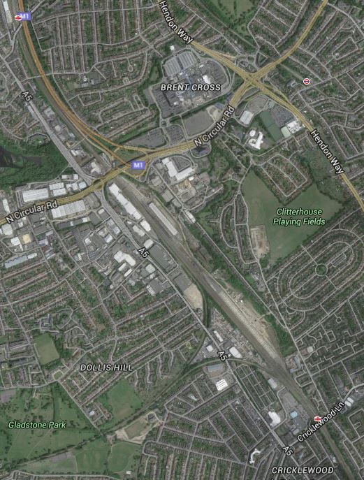
Brent Cross
Note the large area of the current Cricklewood TMD to the North East of the triangular junction with Cricklewood station south of the area. The development will be partly on the northern part of the TMD.
The advantage of the indirect route, would be that the Shopping Centre and all the new development in the area, gets good connections from Hounslow and Acton in the West to Holloway, Tottenham and Walthamstow in the East.
If the trains run at the current four trains per hour of the GOBlin, then this line would be a valuable link across North London connecting to the Midland Main Line and Thameslink at either Brent Cross or West Hampstead stations.
It is an interesting proposition.
But it might get even better!
London’s two big problems are housing and transport, so look sat this Google Map of the area to the East of Gospel Oak station.

A Site To The East Of Gospel Oak Station
There is a large site around the triangular junction formed by the GOBlin in the North, the Midland Main Line in the South and the link between the two lines in the East.
It could be used for much-needed housing and other developments in the future. At the present time, it is owned by J. Murphy and Sons, who by chance are the contractors working on the electrification of the GOBlin.
Look at the map and I think that there is enough space to put a new station on the eastern side of junction.
So trains from Upper Holloway station to the Dudding Hill Line could go through.
- Junction Road if that station is built.
- Murphy’s Town
- West Hampstead Thameslink
- Cricklewood
- Brent Cross Thameslink
I think that some of the out-of-the-box-thinkers at Transport for London will come up with some extensive knitting in North London.
Look at this Google Map, which shows the GOBlin through Harringay.
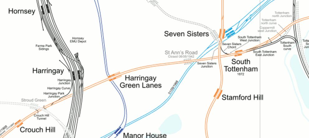
Lines Through Harringay
The GOBlin is or could be very well connected.
- The connection to the East Coast Main Line is being electrified.
- Harringay Green Lanes station sits on top the Piccadilly Line.
- Seven Sisters station will be connected to South Tottenham station by Crossrail 2.
- It is linked to the Lea Valley Lines south of Tottenham Hale station.
Who knows what Transport for London will do with the GOBlin?
I wonder if in conversations in the pub near TfL’s offices, they wish that they still had the Palace Gates Line to play with. You can see it’s line on the map above as it goes away to the North West from Seven Sisters station.
I do find it strange however, that the route of Crossrail 2 from Seven Sisters to New Southgate, very much follows the route of the Palace Gates Line.
So can we assume, that the Victorians got that one right too?
Improving London’s Transport In Small Ways
I feel there are two ways of getting more out of London’s crowded transport system.
The first is the obvious ones of capital projects, which at the top end is Thameslink, Crossrail and Crossrail 2, and at the bottom end it is projects of the order of small numbers of millions, which might include.
- Remodelling major junctions like Archway, Elephant and Castle, Highbury Corner and Old Street.
- Reorganising bus routes around train and Underground stations, with more shelters and better information.
- New and rebuilt stations like Crystal Palace, Deptford and Lea Bridge
- Inclined lifts like that installed at Greenford.
- Step-free access at stations like Clapham Junction, Gospel Oak, Honor Oak Park, New Cross and South Tottenham.
I’m sure that new technology epitomised by the inclined lift at Greenford, will increasingly be seen.
But with any complex system, there is always improvements to be made in small ways.
The recent extension of contactless cards to Gatwick Airport, could be the sort of improvement, that increases ridership on the trains to the airport and is very much a win for the airport, the train companies and passengers alike.
We need more small improvements to London’s transport system to squeeze more capacity and improved efficiency out of the network.
1, London’s Airports And Other Places Should Have Contactless Ticketing
Heathrow, Luton and Southend Airports will join City and Gatwick in coming within London’s contactless ticketing network.
But why stop at just airports?
I feel that within a few years, the following will be within London’s contactless ticketing area.
- Chafford Hundred for the shopping at Lakeside.
- Ebbsfleet International for trains to Europe.
- Greenhithe for the shopping at Bluewater.
- Thorpe Park and other places for the fun!
- Windsor and other places for the tourists!
The benefits to residents, tourists, business and train companies won’t be small.
I suspect that as the contactless ticketing network grows, attractions and towns outside the area, will be enthusiastic to join and might even bribe Transport for London.
2. Buses Should Trial Entry Through All Doors
The bus journey I do most commonly is to get a 38 or 56 bus between my house and the Angel, where I tend to do my food shopping.
The 38 route uses New Routemasters with three doors, all of which can be used for entrance and exit, whereas on the 56 route, standard two door buses are used, where you enter through the front door and exit through the one in the middle.
There is no question that the Routemasters get through a typical stop quicker, as drivers and passengers use their brains to get on and off the bus as fast as possible. However, on the standard buses, threading a push-chair into the middle of the bus can be difficult and time consuming.
I think that an experiment should be trialled, where in perhaps areas, where there are a lot of Routemasters, passengers can board the standard buses from the middle door and touch-in on a convenient reader.
Obviously, it would be open to fraud, which is why an experiment would have to be performed first. But from several years of watching passengers on New Routemasters, I don’t think losses would be substantial. Many a time, I’ve seen passengers collectively stare at another passenger, who didn’t touch in! It’s East London peer pressure at work!
Remember too, that the doom-mongers of the left, felt cashless buses and contactless payments would be a disaster and discriminate against the poor. Try finding an incident, where someone was severely inconvenienced by London’s contactless ticketing system!
3. All Stations Should Indicate The Train Direction
On some stations this is obvious, or can be worked out, as on heavy rail routes, trains drive on the left.
But on many Underground stations, it is not obvious from which direction your train will arrive.
Often regular passengers will know that when going to a specific station, they will need to be in a particular carriage. If I am coming North to Angel on the Northern Line, I want to be in the first or second car, as this saves the effort of walking down the platform.
A simple arrow above the sdverts say, would orient you on the platform.
Hopefully, it would distribute passengers in a better manner along the platform.
4. Some Rail |And Underground Maps Could Be Larger
The standard maps are fine, but over the years, I’ve seen some really large transport maps around the world.
There’s no doubt in my mind that with maps, big is beautiful and the bigger the better.
In many stations there is a large tiled wall, for which no-one has really found a sensible use. Often you’ll come down an escalator into the bowels of an Underground station and face such a wall.
So why not put a really large map there?
It would be out of the way too and if passengers just wanted to stand in front of it and look, no-one would bother.
5. More First Train Indicators At Terminal Stations
Some terminal stations have more than one platform from which stations start their return journeys.
At Walthamstow Central on the Victoria Line, where there are two platforms, an indicator tells you, from which platform the first train will leave.
But at other stations like Stratford on the Overground, it is difficult to ascertain which will be the first train to travel west.
All terminal platforms should be fitted with First Train Indicators.
6. Better On Board Bus Information
London’s buses have a simple display, which gives a selection of the following information.
- The route and the destination.
- The name of the next stop
- Any customer information like delays, strikes or closures.
- The time.
I know the size of the display is limited, but it is poorly arranged and could be much better.
It should also show the five-number code of the next stop, so that passengers changing there could check out their next bus.
7. All Stations Should Have TfL-Standard Rail/Tube, Bus Spider And Walking Maps
When you arrive at a Transport for London (TfL) managed station, you find the following maps prominently displayed.
- The Rail and Tube version of the iconic Underground map.
- A bus spider map for all the routes serving the area.
- A comprehensive walking map.
At most TfL stations, there is increasingly a Legible London lith.
But this is not the case at some stations in London, that are managed directly by railway companies.
All stations should be made to adhere to London’s standards.
8. Below Ground Information Needs To Be Improved
Crossrail will bring some truly labyrinthine stations to London, to add to those difficult to navigate ones like Bank, Green Park, Kings Cross St. Pancras and Waterloo.
Transport for London needs to provide more bus and walking maps on the platforms and in the passageways, so that passengers can find their way to the entrance they need to continue their journey.
9. Rail And Tube Map On All London-Bound Platforms
The need for this was illustrated at Coventry station, where two tourists were asking the Virgin station-man, how to get to Ewell West from Euston. He told me, he had asked for a London Rail and Tube Map for the station, as this would have answered a large proportion of the questions he was asked.
The map could also have full details on how to use London’s contactless ticketing, which should reduce the queues at London terminals.
The only station outside London, I’ve seen such a map is Cardiff Central.
If it’s good enough for Wales, then the map should be displayed in Amsterdam, Brussels, Cologne, Lille, Marseilles and Paris.
Obviously, with information in the correct languages!
10. There Needs To Be More And Better Ticket Machines
Increasingly, I use the Internet less and less to buy tickets for travel out from London, unless it’s a longer journey and I want to reserve a seat.
I get the best Internet price from the latest ticket machines at Dalston Junction station, where I can buy the following tickets.
- Singles and returns, for today or a date in the near future between any two stations in the UK.
- Extension tickets from the Zone 6 boundary to certain stations close to London.
I get the best Internet price, without having to sign-up to be bombarded with spam by the train or ticket company.
The Zone 6 extension tickets are often a big money saver. Recently a return to Woking cost me just £5.15 with my Senior Railcard. The Standard Class Return Ticket costs £14.10, so the saving almost paid for my lunch in Woking.
These ticket machines need to be in a lot more places and not just on the Overground.
11. Ban Diesel Trains As Much As Possible From London
Despite lots of electrification on the lines into and through London, their are still quite a few noisy and smelly diesel trains to be found in London. They fall into the following categories.
- Long-distance trains like those to the West Country, Wales and Scotland.
- Freight trains on through routes, like the North London and Gospel Oak to Barking Lines.
- Commuter services using diesel multiple units.
- Engineering trains haled by diesel locomotives.
I believe that many of these can be replaced by trains hauled by quieter and greener electric traction.
Many residents of London, especially those who live on the feight routes of North London, would back this small improvement.
Conclusion
I have detailed ten small ideas, that might be used to improve London’s transport network.
I think that only the provision of more and better ticket machines will cost serious amounts of money, but from what I see as I travel around London, I suspect it’s already being done.
If I was the London Mayor, I would ask Londoners and regular travellers for simple ideas to improve the network.
Some would be bonkers, some would be so-so, but I believe that some would be brilliant.
I also believe that those good ideas, that were worthwhile implementing, should result in a reward to the proposer.
After all, London’s transport network belongs to London and Londoners, so why shouldn’t they have a say in its design?
London’s New Stations
This is a list of the new stations that are being built or are proposed for the London area.
- Battersea Power Station – Being built for Northern Line Extension – Opening by 2020
- Brent Cross Thameslink – Outline planning permission
- Canary Wharf – Being built for Crossrail – Opening in 2018
- Cassiobridge – Being built for Croxley Rail Link – Opening in 2020
- Lea Bridge – Being built – Opening in 2016
- Maiden Lane – Proposed for North London Line
- New Bermondsey – Being built for East London Line
- Nine Elms – Being built for Northern Line Extension – Opening by 2020
- Old Oak Common – Being planned for Crossrail and HS2 – Opening in 2026
- Primrose Hill – Proposed for North London Line
- Silvertown – Proposed for Crossrail
- Watford Vicarage Road – Being built for Croxley Rail Link – Opening in 2020
- West Hampstead Interchange – Proposed
- Woolwich – Being built for Crossrail – Opening in 2018
There are of course other proposals in the dreams of London’s many local authorities.
