Northern Powerhouse Rail – A New Line Between Liverpool And Manchester Via The Centre Of Warrington
In this article on Transport for the North, which is entitled Northern Powerhouse Rail Progress As Recommendations Made To Government, one of the recommendations proposed for Northern Powerhouse Rail is a new rail line between Liverpool and Manchester via the centre of Warrington.
I shall look at a few of the possibilities for various sections of the line starting at the Manchester end.
High Speed Two And Northern Powerhouse Rail Between Warrington/Lymm And Manchester Airport
This map clipped from High Speed Two’s interactive map, shows the route of High Speed Two in the area between Lymm and Manchester Airport.

Note.
- High Speed Two is shown in orange
- The blue dot is Manchester Interchange station at Manchester Airport.
- High Speed Two goes North to Wigan North Western station.
- High Speed Two goes South to Crewe station.
- High Speed Two goes East to Manchester and the East.
- The East-West Motorway is the M56 with Junction 7/8 in the middle of the map and Junction 9 with the M6, at the Western edge of the map.
This enlarged map shows High Speed Two between Manchester Airport and Junction 7/8 of the M56.

The colours of High Speed Two indicate the type of construction.
- Black is a bored tunnel. Only in the North East corner, where it continues to Manchester.
- Brown is a track between retaining walls. Used through Manchester Interchange or Airport station.
- Red is a viaduct.
- Yellow is a cutting.
This Google Map shows a similar area.

High Speed Two’s tracks will be on the South side of the Motorway and will be shared with Northern Powerhouse Rail.
- There is likely to be up to twelve trains per hour (tph) in both directions.
- I would think, that with modern signalling that the trains would be running at 140 mph or more.
- Between Manchester Airport and Warrington could be a line as between St. Pancras and Ebbsfleet on High Speed One.
This map clipped from High Speed Two’s interactive map, shows the M56 and High Speed Two around Junction 7/8 of the M56.

The colours are as before.
- The obvious way to build a new rail line between Manchester and Warrington, would surely be to create a rail junction just South of the Motorway junction.
- A line to Warrington could run along the South side of the Motorway.
- I also believe that there should be a connection between the High Speed Two lines to Manchester and Wigan North Western, to allow high speed services between Manchester and Barrow, Blackpool, Preston, Windermere and Scotland.
Building the rail junctions around the Motorway junctions would be a good idea for environmental and visual reasons.
Northern Powerhouse Rail would then continue to Junction 9 of the M56 Motorway.
This Google Map, shows the M56 around Junction 9 with the M6.

Note.
- The M56 running East-West.
- The M6 running North-South.
- Lymm services to the North-West of the junction.
- Lymm is to the North-East and Warrington is to the North-West of the junction.
Would it be possible for to run South of the M56 and then turn North to run along the Western side of the M6 towards Warrington?
I very much feel, that with modern 3D software, an engineer with expertise in extreme knitting could thread a double-track line through to take a North-Western route towards Warrington.
The Bridge Across The Mersey
If you look at maps of the area, there is a big problem of water between Junction 9 of the M56 and Warrington town centre, with its two stations of Warrington Bank Quay and Warrington Central, both of which have services to Liverpool Lime Street station.
The problem is the Manchester Ship Canal.
I then noticed a bridge to the South East of the town centre, which is shown in this Google Map.

It may look like it has got more than a touch of the dreaded iron moths, but it certainly looks like it was once a double track rail line.
The bridge was on the Warrington and Altrincham Junction Railway, which did what you would expect from the name.
This Google Map shows the track of the railway either side of the bridge.

Note the bridge in the centre of the map and the green scar of the former railway running East-West across the map.
To the East the green scar of the railway can be picked out all the way to M6.

Note.
- The bridge is at the West over the Manchester Ship Canal.
- The green scar of the Warrington and Altrincham Junction Railway can be followed all the way to the M6,
- I think the track is now a footpath, as it is marked on the map with a dotted white line.
I would be interested to know, if it could take a modern double track railway.
This Google Map shows an enlarged view of where the green scar of the Warrington and Altrincham Junction Railway goes under the M6.

Note the dotted white line marking the railway, towards the top of the map.
Would it be possible to design a track layout, where Northern Powerhouse Rail came up the Western side of the M6 and was able to connect to Warrington?
I certainly believe it’s a possibility.
Warrington Bank Quay Station
To the West of the bridge over the Manchester Ship Canal, the Warrington and Altrincham Junction Railway ran through low-level platforms at Warrington Bank Quay station.
This Google Map shows Warrington Bank Quay station.

This picture shows a freight train passing under Warrington Bank Quay station.

Note.
- There are four North-South platforms on the West Coast Main Line.
- The Warrington and Altrincham Junction Railway passes East-West under the four main platforms.
- Low levels platforms used to handle passengers on the East-West lines.
- I was looking to the East in the picture.
- The tracks continue to the West on the route of the former St. Helens Railway, which is now a freight route.
- The map shows the tracks curving sharply round one of the meanders of the River Mersey.
Warrington Bank Quay station is on a congested and tight site, but by using some of the spare railway land, I feel it could rebuilt to be an excellent station for Warrington.
Warrington Bank Quay Station As An Interchange
Warrington Bank Quay station could be an excellent and efficient interchange between High Speed Two and Northern Powerhouse Rail.
There are also local services from the station, which could be useful for some travellers.
Between Warrington Bank Quay Station And Widnes
This Google Map shows the Mersey estuary between Warrington Bank Quay station and Widnes.
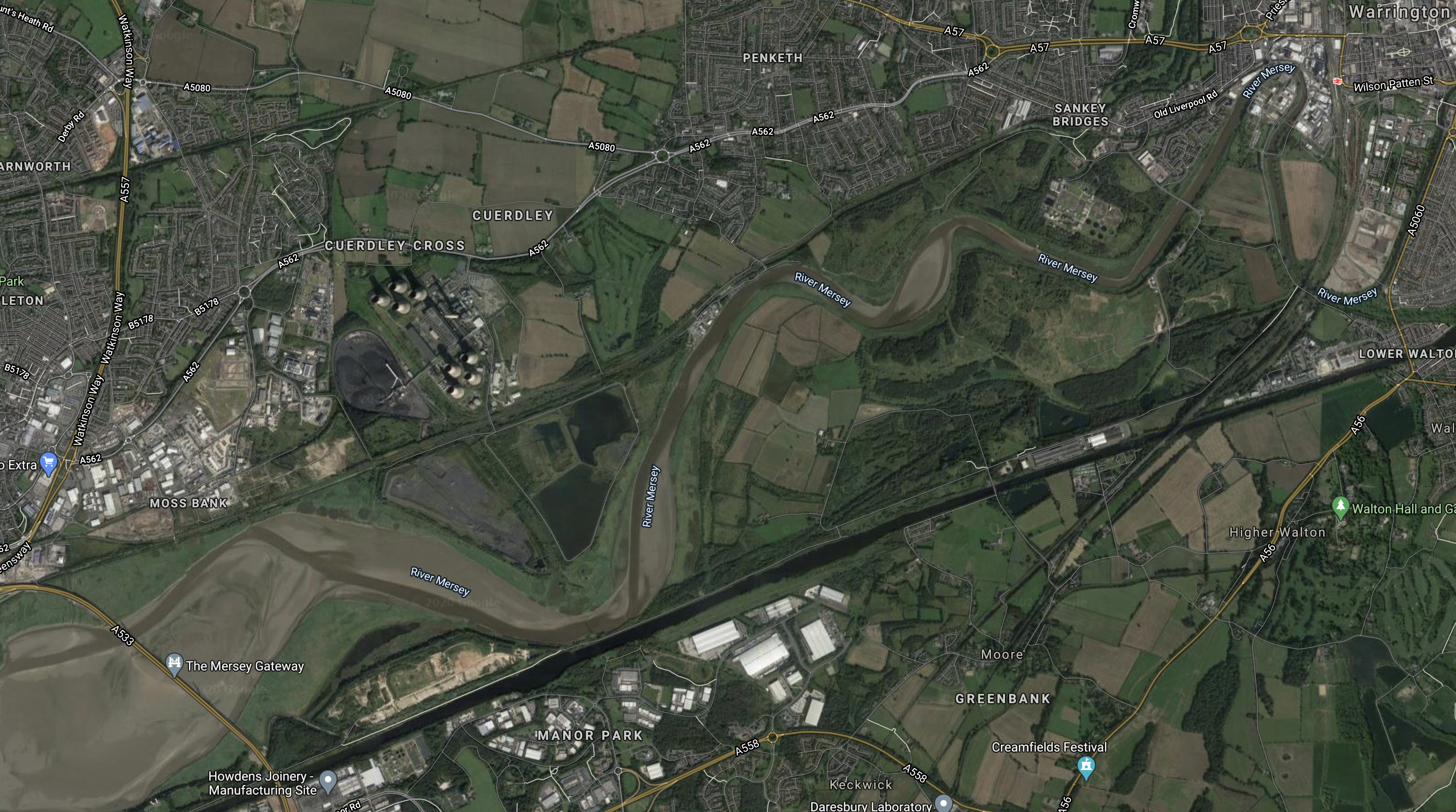
Note.
- Warrington is in the North-East corner of the map, with Warrington Bank Quay station shown by a red station symbol.
- The new Mersey Gateway bridge is in the South-West corner of the map.
- The River Mersey meanders between the bridge and Warrington.
- Fiddlers Ferry power station can be picked out in the nearest meander of the Mersey to the bridge.
- The dark straight line below the river is the Manchester Ship Canal.
- There is currently a freight line on the North bank of the river.
This Google Map shows Fiddlers Ferry power station, with the railway between the now-decommissioned power station and the River Mersey.

Note.
- Fiddlers Ferry will become an employment site.
- It could even be a good place for a depot for Northern Powerhouse Rail.
- I think there’s scope to increase the operating speed of the railway along the Mersey.
Could it even be an electrified high speed line with a 125 mph operating speed?
Between Widnes And Liverpool Lime Street
The trains coming from Warrington could join the Liverpool Branch of the West Coast Main Line at Ditton East Junction.
The route between Ditton East Junction and Liverpool Lime Street has the following characteristics.
- It has four tracks.
- It is 10.6 miles long.
- Avanti West Coast’s expresses typically take twelve minutes for the trip without stopping.
- The stations on the route; Liverpool South Parkway; West Allerton, Mossley Hill and Edge Hill, all have one platform per line.
- It is fully electrified.
- Lime Street station has recently been updated with longer platforms and a higher capacity approach to the station.
- Some local services have already been moved to Merseyrail’s Northern Line.
- Stopping services on the route have their own platforms.
I believe that with the installation of full digital signalling and a degree of automatic train control, as far as Crewe and Warrington Bank Quay stations, that the following services could be handled.
- Six tph – Northern Powerhouse Rail – Liverpool and Manchester Airport and Manchester Piccadilly
- One tph – East Midlands Railway – Liverpool and Nottingham
- Three tph – High Speed Two – Liverpool and London Euston
- One tph – High Speed Two – Liverpool and Birmingham Curzon Street
- Two tph – London North Western – Liverpool and Birmingham and London Euston
Note.
- This is only 13 tph.
- Avanti West Coast services would be replaced by High Speed Two.
- TransPennine Express services would be replaced by Northern Powerhouse Rail
- The Liverpool and Nottingham service may or may not go via Ditton East junction.
If the capacity on this branch could be raised to 15 tph, that would be only be a train every four minutes, or half the frequency, that will eventually be operational on Crossrail and Thameslink. It would also be less than the 18 tph frequency of High Speed Two.
Conclusion
This simple exercise has proven to me, that a high speed line could be built between Manchester Airport and Liverpool Lime Street station.
- Several sections of the route could have an operating speed of 125 mph or more.
- By running the tracks along the M56 and M6, visual and aural intrusion could be minimised.
- The line along the Mersey through Warrington could be a valuable part of the route.
- West of Warrington, much of the infrastructure needed, appears to be in place and it would only need to be upgraded.
There was a large and extremely pleasant surprise at the Liverpool end.
The approach to Liverpool Lime Street is two fast and two slow lines, and I believe, that this section of the route could handle up to say 15 fast trains and six stopping trains per hour, with full digital signalling.
Unlike London and Manchester, I doubt that Liverpool will need a tunnel to access the City Centre.
I also believe that after its refurbishment of the last couple of years, Lime Street could be substantially ready for High Speed Two and Northern Powerhouse Rail.
Project Management Recommendations
This project divides neatly into three.
- Between Manchester Airport and Warrington along the route of the M56 and M6.
- Reconstruction, upgrading and electrification through Warrington and the rebuilding of Warrington Bank Quay station.
- Reconstruction, upgrading and electrification between Warrington and Liverpool.
The first project will be a major one, involving the construction of nearly twenty miles of new electrified railway, with numerous viaducts, bridges and a large junction at High Legh with High Speed Two.
The other two projects would be a lot simpler and would involve turning twenty miles of double-track freight line into a modern electrified railway.
I would construct projects 2 and 3 early in the schedule, as it would give Warrington a new Bank Quay station. A passenger service to Liverpool Lime Street, could also be opened if required.

There are films of the bridge and earthworks on Youtube. The former Cheshire Lines Committee Railway are already being looked at with a view to reopening.
Comment by jagracer | November 21, 2020 |
[…] A new line to be constructed from Liverpool to Manchester via the centre of Warrington, Read more… […]
Pingback by Northern Powerhouse Rail Progress As Recommendations Made To Government « The Anonymous Widower | November 30, 2020 |
Interesting….what about the actively planned western Link Road which will cross the Fidlers Ferry line near Sankey Bridges. I dont see any bridge….just the normal cutting of the line by the road…..a decison that well surely come to regret
Comment by steveb1878btinternetcom | December 23, 2020 |
The line is still active from Ditton Junction to Arpley and an overbridge is shown on all the plans I have seen. See chosen route with new rail bridge https://www.warrington.gov.uk/sites/default/files/2019-09/revised_red_route_option_-_western_link.pdf
Comment by Rob Gandy | January 3, 2021 |
It looks to me, that some holistic planning is required, so that both NPR and the Western Link Road do the best for Warrington.
Comment by AnonW | January 3, 2021
The so-called “green scar” to the east of the specified redundant rail bridge over the Ship Canal is part of the important Trans-Pennine Trail (walking/cycling) running between Liverpool and Hull. This section which goes eastwards under the M6 and thence through Lymm adopted the old railway line conveying coal to Fiddlers Ferry Power Station, discontinued in the 1970’s (?). This was the line which used the aforementioned bridge over the Ship Canal. Interestingly the Trail did not utilise the bridge and continue on the old line through Warrington (diverting rather awkwardly on to the Mersey Way path to Fiddlers Ferry and beyond) presumably because the bridge is in disrepair/unsafe.
Referring to the idea of re-utilising the bridge and “green scar” as a new “entry” to Warrington, this one-mile- plus stretch ( i.e. as far as M6 corridor) adjoins farmland and there appears to be space to create a new rail-track,in principle. Please leave the Trail intact as it is a vital section and well-used by walkers and cyclists following the Goverment’s keep-fit injunctions!
Comment by Brian Wreford | December 26, 2020 |
Nothing to do with me what happens, as I’m only a blogger in Hackney, but increasingly with new railways we’re seeing conflicts between walking routes and other groups, who want to reinstate railways.
I think, we’ll see several new railways sneaking alongside motorways as HS1 does alongside the M2 in Kent.
But we must find a solution to combining smaller railways with walking routes, that took over the tracks .
Comment by AnonW | December 26, 2020 |
It needs a brand new line not rehash if victorian infrastructure if its goid enough for the midlands its goid enough for the n west
Comment by John innan | March 4, 2021 |
Being from south Liverpool myself, I’m very familiar with the Ditton-Lime street section of track. I think 13 tph is a little ambitious for this section, and you haven’t taken into account the stopping services for the CLC line to Manchester in your calculations, or the service via Runcorn and the Halton curve to chester, and soon to Llandudno/Shrewsbury. That said, they have recently upgraded this section of track to digital signalling, controlled by the Manchester control centre, and taking into account west coast, HS2 and CLC services all converging at south parkway, you’re right, it could handle all these services, but I would suggest 12 tph, in both directions, but only if electric or battery services use the CLC line, such as extended merseyrail services.
It might look like this:
2 tph HS2 services London
2 tph NPR services to Manchester/Leeds
2 tph WCML services to Birmingham/London
2 tph EMR services Sheffield/Nottingham
2 tph CLC services to Manchester
2 tph TFW services to Wales
Comment by Rob Scott | June 27, 2021 |
[…] I talked about this in Northern Powerhouse Rail – A New Line Between Liverpool And Manchester Via The Centre Of Warringto…. […]
Pingback by Warrington Bank Quay Could Become Major Rail Interchange « The Anonymous Widower | March 5, 2021 |
I am 85 next month, please push the job and give me a chance to see this happen, thanks
Comment by Thomas William Peake | November 20, 2021 |
There are press reports today that Labour may soon be announcing a revival of NPR. https://www.theguardian.com/business/2025/aug/13/labour-to-revive-northern-powerhouse-rail-project-trains
Comment by Peter Robins | August 14, 2025 |