The Ultimate Open Access Service
London and Windermere are 223 miles away by train with a single change at Oxenholme Lake District.
In a straight line the distance between Amsterdam and Hamburg is 227 miles.
I’ve done both journeys by train and the continental journey was a pain.
- In From Amsterdam To Hamburg The Hard Way, I describe a typical journey between the two cities.
- In From Hamburg To Osnabruck By Train, I describe how I only got halfway.
I’ve also tried splitting the route at Groningen.
- The first leg was a train to Groningen, where I spent the night.
- I spent the second day exploring and wrote about my experiences in The Train Station At The Northern End Of The Netherlands.
- On the third day, I started by going between Groningen and Leer in Germany.
- This section of the route at present is under repair after a ship destroyed the swing bridge over the River Ems.
- I describe its rebuilding in From Groningen To Leer By Train.
Once at Leer, you’re on the German main line and the route is electrified all the way to Bremen and Hamburg.
I believe that the route would be within the scope of a battery-electric high speed train, such as both Hitachi and Siemens are developing.
Some thoughts on the route.
The Competition
The trains need a change at Osnabruck to go between Amsterdam and Hamburg.
I suspect many travellers fly, as there are thirty-nine flights per week.
The service could be better.
Why Would I Run It As An Open Access Route?
Consider.
- If what I have experienced on the current Amsterdam and Hamburg via Osnabruckservice, then surely an experienced open access operator using trains designed for the route could do much better.
- This service could be run almost as a shuttle between two terminal stations. Several open access services like Hull Trains, Lumo and Grand Central are run this way.
- If a government service fails, governments get the blame, but if an open access service fails, the government gets no blame.
So would some governments, prefer open access operators to take the risk?
Would Any New Infrastructure Be Needed?
Very little if any!
Although, I do feel, that some of the level crossings and bridges could be improved or removed.
Where Is The Route Not Electrified?
The section without electrification is at the Dutch end.
This OpenRailwayMap shows the lines around Groningen station.
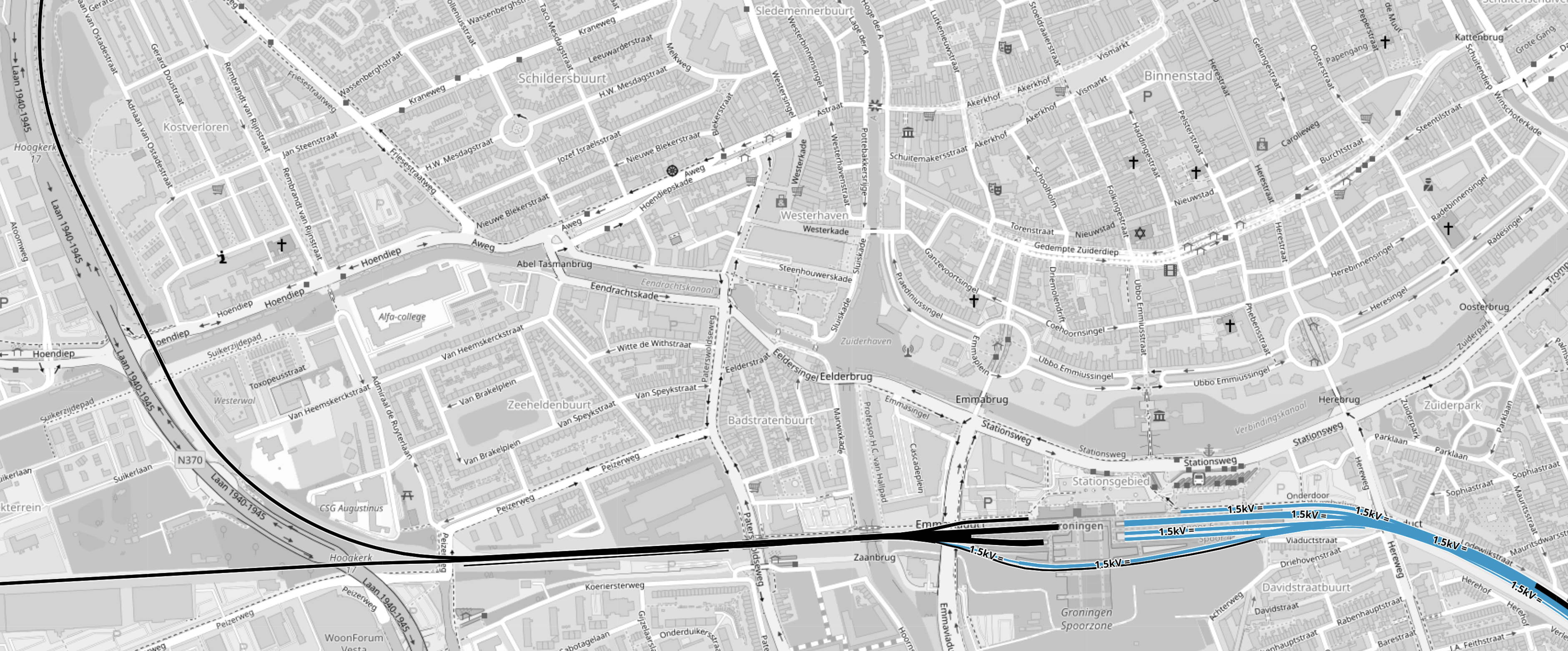
Note.
- Lines in black are not electrified.
- Lines in blue are electrified at 1.5 KVDC overhead.
- The mass of blue lines is Groningen station.
- Hamburg is to the East.
- Eemshaven us to the North.
- Harbinger is to the West.
Amsterdam trains use the electrified lines to the East.
This second OpenRailwayMap shows a wider view of the lines around Groningen.
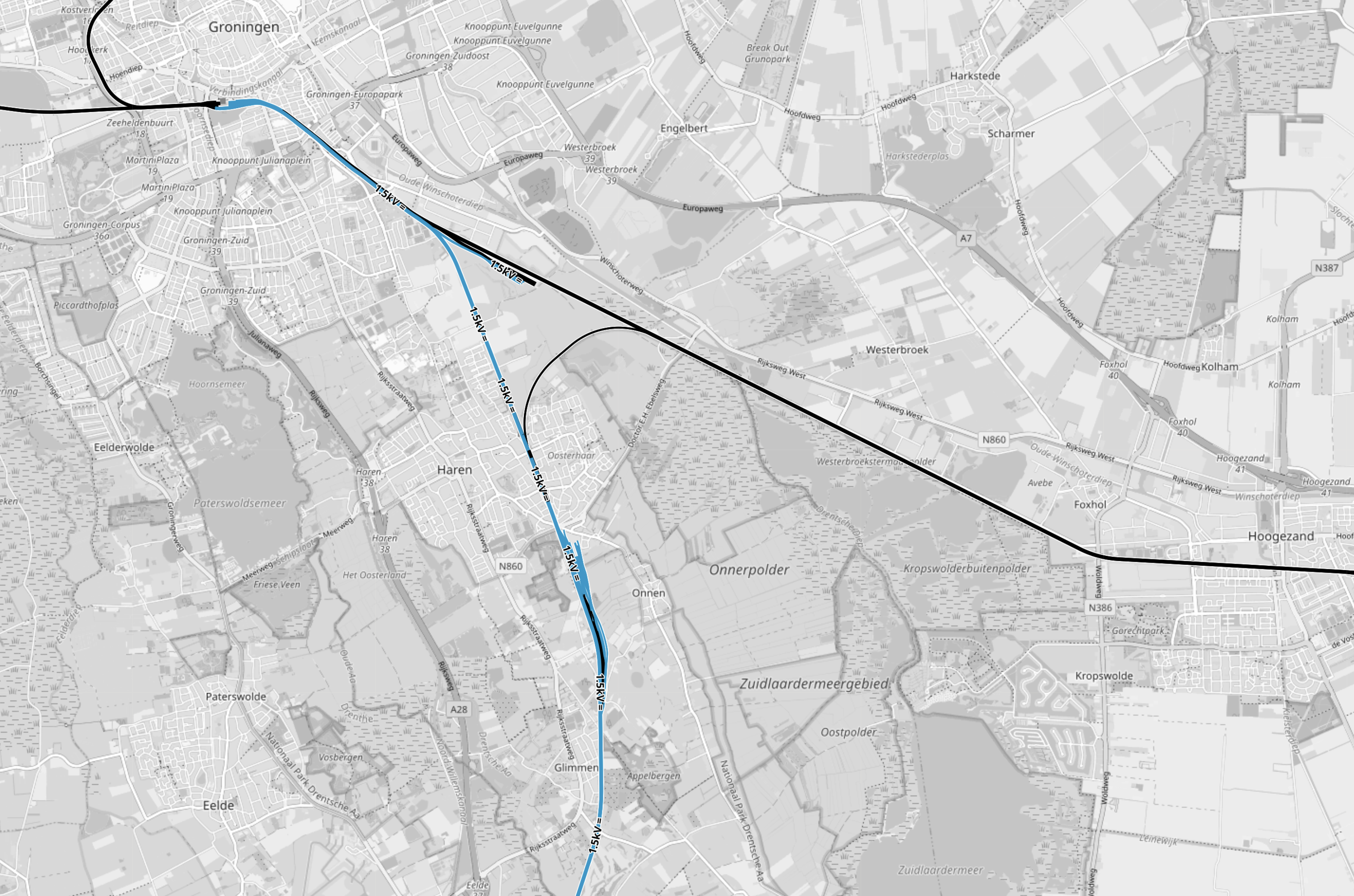
Note.
- Lines in black are not electrified.
- Lines in blue are electrified at 1.5 KVDC overhead.
- Groningen is in the North-West corner of the map.
- Trains between Groningen and Amsterdam use the electrified line to the South via Zwolle.
- Trains between Groningen and Bremen and Hamburg use the unelectrified line to the East.
- There is a single track chord, that would allow trains to go between Amsterdam and Germany.
I suspect that a battery-electric high speed train could be fully recharged before leaving Groningen for Germany.
This third OpenRailwayMap shows between the chord to the East of Groningen and the German railway system at Leer.
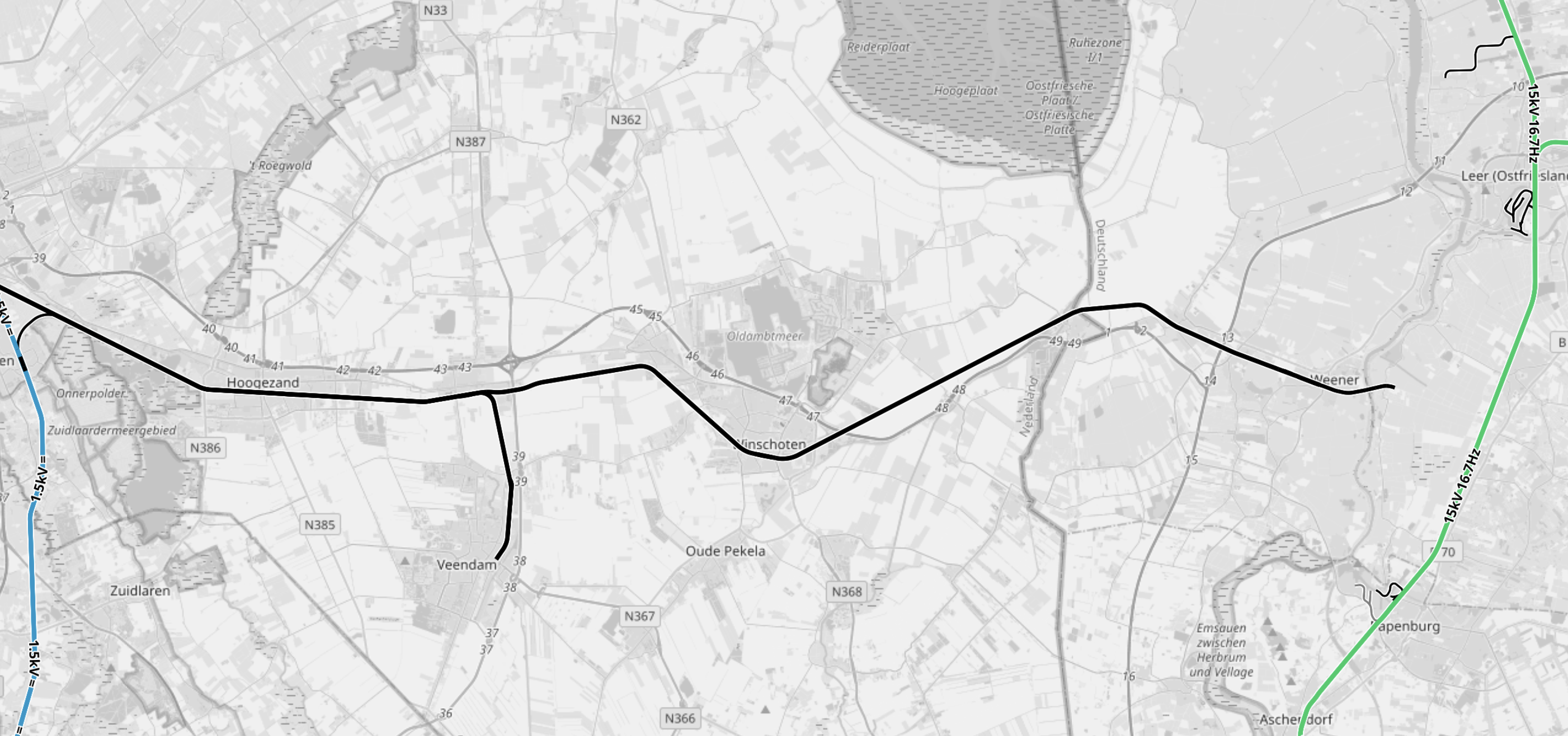
Note.
- Lines in black are not electrified.
- Lines in blue are electrified at 1.5 KVDC overhead.
- Lines in green are electrified at 15 KVAC overhead.
- Groningen is off the Western side of the map.
- The chord connecting the Amsterdam and German lines from Groningen can be picked out.
- The unelectrified line East from Groningen seems to end in the middle of nowhere.
- The green lines in the East of the map are the electrified German railway system.
- Leer station, which is indicated by the tangle of lines in the North-East cornet of the map, has services to Bremen and Hamburg.
This forth OpenRailwayMap shows the Dutch and German railways at Leer.
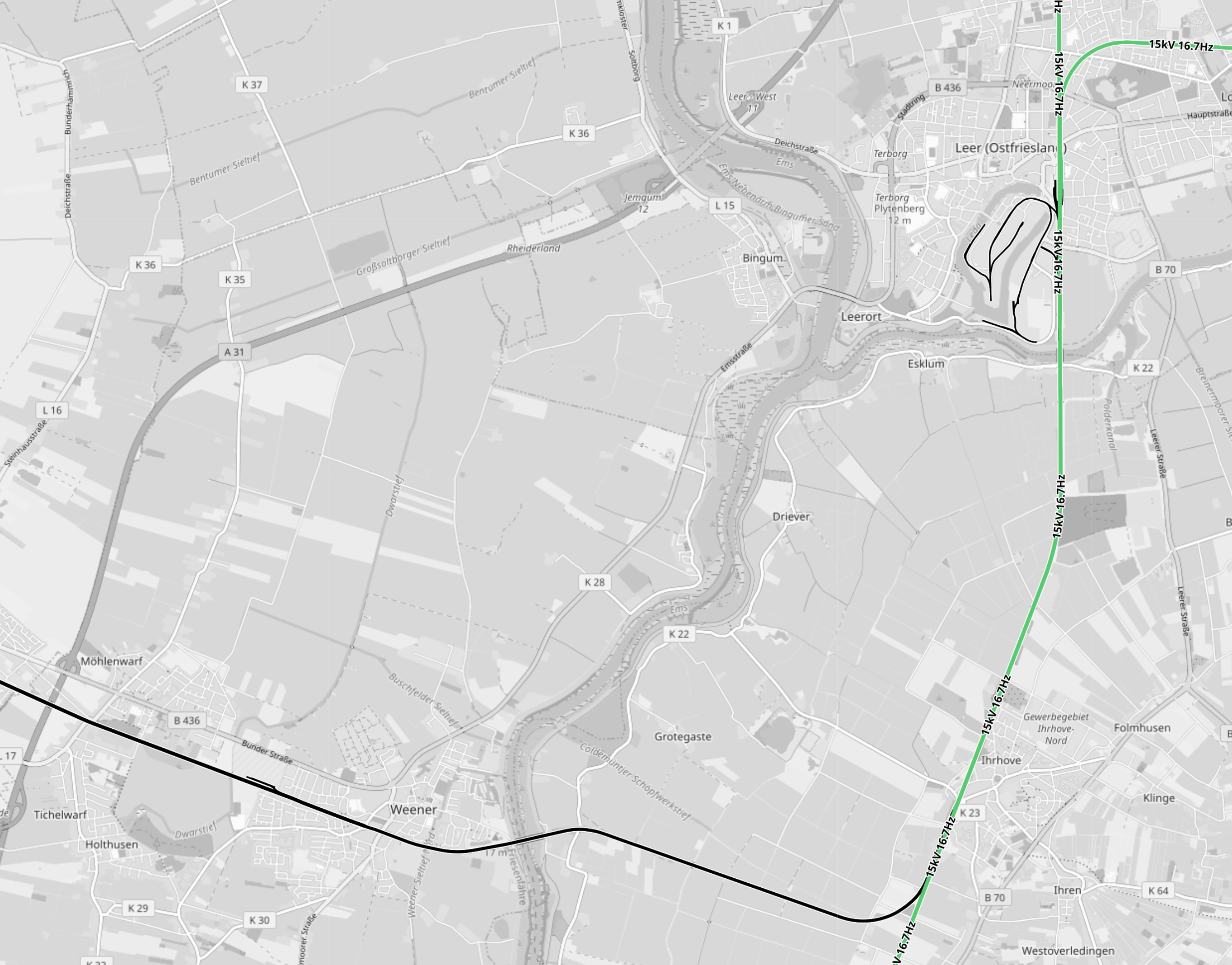
Note.
- Lines in black are not electrified.
- Lines in green are electrified at 15 KVAC overhead.
- Leer station is in the North-East corner of the map.
- The green lines in the East of the map are the electrified German railway system.
- The River Ems runs down the middle of the map.
The unelectrified line East from Groningen seems to link up with the German railway system.
It used to link up until a German freighter called the Emsmoon demolished the Freisenbrücke over the River Ems.
In From Groningen To Leer By Train, I link to two videos and give the history of the accident.
The Freisenbrücke should be rebuilt in the next few months.
It looks like less than fifty miles of the route between Groningen and Leer is not electrified.
As all the other sections of Amsterdam and Hamburg are electrified, a battery-electric train with a range of less than fifty miles would be needed,
But the train would need to be compatible with both the Dutch and German electrification systems.
What Mode Of Trains Would Be Needed?
Trains would need three methods of operation.
- Using 15 KVAC overhead.
- Using 1.5 KVDC overhead.
- On battery power.
Batteries would be charged using regenerative braking or overhead wires, where they exist.
Lumo’s recently ordered Hitachi trains will probably work the same way.
Conclusion
This could be an open access service that could work.
