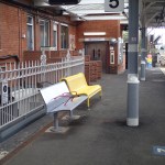
Before Crossrail – Romford
An Important Schizophrenic Station – Rating 6/10
Romford is an important station on this line and it is the middle of a fairly large High Street shopping centre.


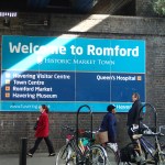

Although it has some marble facings in the booking hall, it has terrible stairs and passages everywhere.
The station is crying out for lifts, especially as when Crossrail arrives some might transfer to Crossrail here from services that come from further afield.
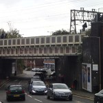
Before Crossrail – Gidea Park
The Bridge Is Falling Down – 6/10
Gidea Park is another station where I’ve not been before.

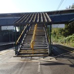


One of the station staff told me, that the bridge had obvious corrosion problems and it was being replaced with one with lifts.
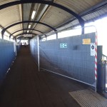
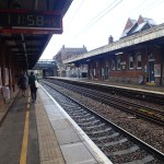
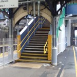
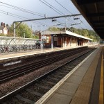
Before Crossrail – Harold Wood
A Tidy Station With A Bad Bridge – 6/10
Harold Wood is a station that is deep in my mind, as it the Zone 6 boundary, so I’ve bought many tickets from the station to Ipswich and other places in East Anglia.
But I’d never visited the station before.


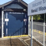

The station has toilets but a bad bridge and no lifts.
It won’t take much to get it ready for Crossrail.
Before Crossrail – Brentwood
A Tidy Station With Good Access – Rating 7/10
Brentwood station needs very little work to bring it up to the required standard. But then it has been upgraded in recent years.


A surprise here was the number and excellent standard of the toilets.
Before Crossrail – Shenfield
A New Platform, Signs And Displays And It’s Ready – Rating 8/10
Shenfield is the station at the end of the Eastern Branch of Crossrail.
Other than creating a new platform for Crossrail, the station is nearly ready, except for sign-age and display screens.


There are certain issues that will have to be decided before Crossrail opens.
- At present Shenfield is outside of Zone 6 and I can’t get there using my Freedom Pass. Will that change, when Crossrail opens?
- Will the fast and slow lines at the station, be reorganised to make interchange between Southend and Norwich/Ipswich services to Crossrail, just a simple walk across the platform?
- The station is in Essex, but should it have bus maps and signs to the London standard?
I don’t think that there’ll be much controversy when this station opens.
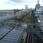
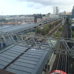
Before Crossrail – Stratford
Little of Note Is Left To Be Done – Rating 9/10
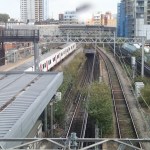
Stratford is the station, where you can get a good idea about the major effects Crossrail will have, as the two Shenfield Metro platforms, which will become the Crossrail ones, interchange on the surface with the Central Line.
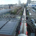


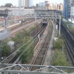

This interchange is almost unique in London, where an Underground line offers cross-platform interchange to a main-line service. At present, it only means that Shenfield Metro passengers can go easily to and from Central and West London.
But with Crossrail it will be even more important as twelve ten-coach Crossrail trains and upwards of thirty Central Line ones will be passing through the station every hour.
Journeys such as Epping to Heathrow, which can be tortuous and long at present would just need a simple cross-platform change at Stratford.
It is obvious that Crossrail will take the pressure off the Central Line, as the very crowded section I often use from Marble Arch to Liverpool Street, will effectively be duplicated by the new line.
What is less obvious to those from outside East London is that Crossrail helps to solve the Central Line’s poor connectivity between Liverpool Street and Stratford, as it brings Whitechapel into the mix, with all the connections that station offers.
I have watched many times how this Shenfield Metro/Central Line interface works and I’m surprised that it is not duplicated all over the UK’s rail network. I can think of only a couple of places where, you arrive at a large main line station and all of the local services are just a walk across a wide platform.
I suspect that if I come back here in say 2020, the station will look very much the same, except that it will probably have had large cosmetic applications of purple paint.
Before Crossrail – The Shenfield Metro
The Shenfield Metro is a six trains-per-hour local service from Shenfield to London Liverpool Street, run using over thirty years old Class 315 trains.
In the next few years the service will be incorporated into Crossrail and form an Eastern branch that will be linked through the central tunnels to heathrow and Reading. Wikipedia says this about the service, when Crossrail is up and running.
At peak hours the frequency of service will increase from seven trains per hour to 12, necessitating the construction of a new 210-metre long platform 6, which will be built to the north of platform 5, replacing one of the existing three western sidings.
The trains will also be longer at ten opposed to eight coaches, so there will be a gigantic increase in capacity.
Changes start next year, when in May the Shenfield Metro will be taken over and run by Crossrail from May.
So I went to Stratford and then took a train to Shenfield, before coming back a stop at a time, to see the current service in action.
Should Thameslink Be On The London Tube Map?
in 2018, Crossrail and an updated Thameslink will be fully opened to form an East-West/North-South railway crossing London.
Transport for London has stated that Crossrail will be added to the tube map, but should Thameslink be added as well?
In the 1980s, Thameslink was for a period on the tube map, as is indicated in this forum.
But the tube map is very crowded around St. Pancras and Farringdon, which probably led to the line’s removal.

London Tube Map
To make matters worse the upgraded Thameslink will call at more Underground and Overground stations, like Finsbury Park, Peckham Rye and Denmark Hill.
So to put Thameslink on the 2018 tube map might not be very easy.
Why Is London’s Transport So Well Mapped?
I’ve travelled all over the UK and a lot of Europe in recent years, and as I don’t drive, I have to use public transport.
What amazes me, is how poor mapping is in most cities and towns outside London.
There are exceptions like Munich, Glasgow and surprisingly, Ipswich, but most are pretty terrible. I’ve even had a letter in The Times complaining how bad the situation is in the UK.
So why is London so much more advanced with its maps, information and wayfinding?
In the 1920s and 1930s when the Underground was going through a major expansion, they probably had a problem with passengers not knowing where they could go!
So this led to Harry Beck‘s iconic Tube map, a version of which is still use today.
In the 1950s, when I started to explore London on my own, my mother told me that if I got lost to find a Tube station, as they had a tube map to me back to Oakwood and a local street map to find what I was looking for. It is still the same today, except that the tube map is more comprehensive and the local maps are generally larger and much better.
Over the last few years London has applied the pre-war principles to the buses, with bus route or spider maps that could have been designed by Harry himself and local walking maps at every bus stop with a shelter.
And then there’s Legible London and all its liths and fingerposts. Wikipedia sums it up like this.
Unlike other wayfinding projects, Legible London leaps over bureaucratic boundaries in order to provide one consistent visual language and wayfinding system across the city. This city–wide approach was implemented to help visitors and local residents to easily gain local geographic knowledge regardless of the area they are in.
In contrast if you go to the Manchester area, Manchester uses one design and Salford another.
London is different to other UK cities and most in Europe, in that it is so much larger.
Consequently, most Londoners are regularly a visitor in their own city, when they find themselves in a part of the city they don’t know.
And of course this applies to those who manage the city, so they appreciate the problem.
If you take a city like Nottingham or Liverpool, most of the locals probably have the city in their head, so they can’t see the point of providing consistent visitor information all over the area. And if it were to be installed, many locals would see it as a waste of money.
So I believe that London’s size is the main reason its information system is so good.
But you must add the tradition started by Harry Beck! He may not be lauded as a great artist, but surely the London Tube Map is one of the greatest examples of public art of all time.
Lib Dems Dither Over More Runways In The South East
According to a report on the BBC web site the Lib Dems are thinking of making a U-turn over their aviation policy of no more runways in the South East. This is the first bit of the article.
The Liberal Democrats are heading for a possible U-turn over their opposition to airport expansion.
The party has been committed to a blanket ban on the construction of any new runways in south-east England.
But two Lib Dem MPs at the party’s conference in Glasgow have tabled an amendment that would allow Gatwick Airport to be exempted.
I have been feeling that the only policy on airports in the South East that will work in the short-term, is to wait until we’ve seen the Crossrail/Thameslink effect work its way through the system. This will make Central London an enormous terminal to the current three runways at Heathrow and Gatwick. No-one can predict how the passengers will react, but coupled with the growth of Manchester Airport, I suspect that the transfer traffic at both Heathrow and Gatwick airports will decrease as a proportion of traffic over the next few years.
As I write this note it has just been announced on the BBC that Virgin is closing their Little Red airline.
Virgin Atlantic has said it will stop running Little Red, its UK flight network launched in 2013, next year.
The flights between London Heathrow and Manchester will stop in March, while those between Heathrow and Edinburgh and Aberdeen will end in September.
Obviously, it hasn’t been bringing in the transfer passengers for Virgin’s long haul flights.
We should be pushing on with developments that will take the pressure of runways in the South East.
1. Eurostar has just announced that they are making Geneva services easier from St. Pancras. The trains could go to direct to places like Amsterdam, Cologne, Geneva and Lyon from London now, if only governments could sort out the political problems, like immigration and security.
As the European high-speed network grows, we could be seeing a large shift from plane to train, which will mean a big reduction in short-haul services from the South East airports.
The French are even talking about building a new line to make London to Paris under two hours. If they could make onward connections in Paris easier, it would increase the number of passengers going by train from London. Better and more welcoming French stations in the style of St. Pancras and Kings Cross would help too!
2. Over the next few years we will see a tremendous improvement in the rail services between Scotland and the South East. Both the East and West Coast Main Lines are being upgraded to remove bottlenecks and allow running at 225 kph, allowing Edinburgh and Glasgow to be within the magic four hours from London. So will most passengers between the South East and Central Scotland, go by train at the end of this decade?
I think they will and we must do those improvements that make England Scotland rail services even better.
3. An interesting knock-on from the previous point, is that even today Glasgow to Heathrow Airport by train, takes well over two hours longer than going to Manchester Airport. The train services have increased in recent months, but Scots are increasingly seeing Manchester as their long-haul airport of choice.
We should be improving the rail links across the North of England as fast as we can, so that if you live North of the line between the Mersey and the Humber, you use Manchester as your long-haul airport.
All this can only make Manchester Airport a bigger rival to the airports in the South East. British Airways might not like it, but they should fly where the passengers are, not where they say they should be!
4. HS2 from London to Birmingham, will make is easier to go to Birmingham Airport from the South East. This extract is from Wikipedia.
According to Birmingham Airport‘s chief executive Paul Kehoe, HS2 is a key element in increasing the number of flights using the airport, and patronage by inhabitants of London and the South-East, as HS2 will reduce travelling times to Birmingham Airport from London to under 40 minutes.
That makes Birmingham Airport closer to Central London than Stansted, so will we see more flights out of London Birmingham International.
5. Trains though, have some very big advantages advantages over flying.
- They generally go from city centre to city centre, where major cities are concerned.
- There is generally, no requirement to get to the station and be subjected to endless security checks, except possibly in Spain. It’s certainly turn up at the barrier with a valid ticket, which has often been purchased just a few minutes before, sit in your seat and go. When was air travel last like that?
- The UK is also showing the way with creating stations, which are very welcoming with decent shops, bars, cafes and restaurants. St. Pancras must rate with the best airports for what it provides the customer.
- But on the trains, we are seeing more and better services, with an improvement in on-board services like wi-fi and catering.
6. Virtually, the only advantage left to flying by air, is that you can drive to the airport and leave your car in the long-term car-park.
For many though, this is decreasingly becoming another facet in the old adage – Time to spare, go by air!
7. Those wanting a new runway in the South East are discounting ingenuity and innovation.
- Ryanair have said that they will be starting low-cost transatlantic services. Knowing them, they won’t be using an expensive airport in the South East.
- Icelandair have been very successful at getting passengers to split their transatlantic flight. So will we see the same happening in London? Perhaps fly from America to London, where you check out the city and then onward by train or short-haul flight to Europe. This will be more relaxing and London will benefit.
- Airliners will get bigger and quieter, so the amount of runway space we’ll need will be less, but the number of passengers through each airport will rise. The latest Boeing 737s to be delivered in 2017 will carry 220 passengers, as opposed to about 160 today. So if all airliners have that sort of increase in capacity, that is almost equivalent to an extra runway for Heathrow and Gatwick.
So perhaps we’ll get the extra capacity without building it?
But in the end are the passengers having the final say and not flying in the same ways they have for years?
I think that any political party that backs another runway in the South East wants its credentials examined.
