Birmingham Gets A Big Snow Job
It is said by many in the regions of the UK, that London gets and eats all the pies.
At present there are four main rail projects on the go in London; Thameslink, Crossrail, the Northern Line Extension and the London Overground.
Thameslink is a government funded project, whereas Crossrail and the NLE are paid for wholly or in part by property developers and business.
The smaller Overgroundisation of London surface railways is more a methodology that is starting to be copied and expanded in places like Merseyside, the Cardiff Valleys and the West Midlands. Although you could argue that other railways in the UK have had the same idea of frequent clean and sometimes new trains, smart stations and good staffing levels, working for some time. Some of the stations on the Overground, have been or will be expanded, in conjunction with property development.
But other projects where co-operation between Network Rail, rail companies.local government and property developers are starting to be proposed and implemented, Often these projects are led by a major redevelopment of a station.
1. Leeds Station
Leeds station was rebuilt and extended a few years ago, but little use was made of the space above the station.
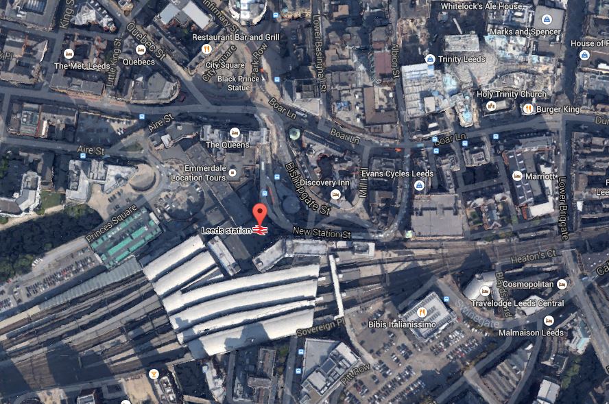
Leeds Station And City Centre
This Google Earth map shows the central location of the station and also its closeness to the main Trinity Shopping Centre at the top right of the map. Walking routes between the two are not good and the station should have been improved with development on the northern side to link it to the city centre. According to Wikipedia. future plans are in place to add much needed extra platforms and develop the south side of the station.
I believe, that you should walk out of a station into an open space, from where you can get your bearings of the city. This has been done well at London Kings Cross, Liverpool Lime Street, Huddersfield and Cardiff Central and some station rebuilding and expanding, is embracing such a concept.
I hope that Leeds develop the concept to a new level, when they create a new southern entrance. Perhaps on a personal level, they could create an easy way to get a bus to Elland Road.
2. Reading Station
Reading station has also been rebuilt and is surrounded by development, as this Google Earth map shows.
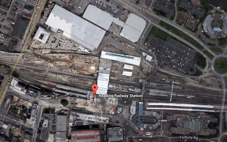
Around Reading Station
In the future it will be getting Crossrail,the new western link to Heathrow and probably more offices around the station. Network Rail, who now manage the station, have already created entrances on both sides of the station and I hope that development in the next few years, will make what is a spectacular station, a true gateway to the City.
3. Birmingham New Street
Birmingham New Street station is approaching the end of its rebuilding, which is now Gateway Plus. It includes a lot of retail including a new John Lewis. The station will also be connected to the Midland Metro. This Google Earth map shows the station and it’s surroundings.
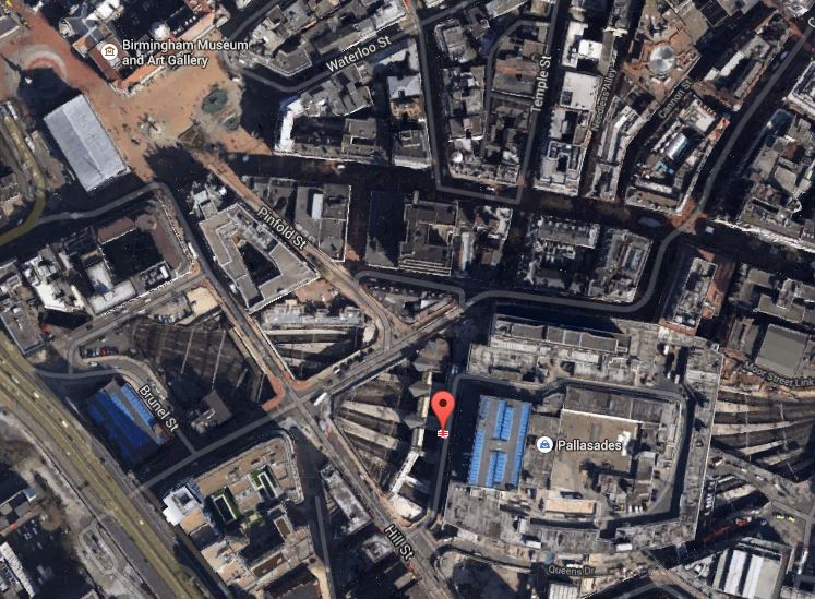
Birmingham New Street
It shows the problem that the station suffers, when compared to many. It is in a deep dark hole surrounded by busy roads, with the buses some way away. I don’t think you would design a station like that these days, as they did in the 1960s.
The station has a problem, as does Leeds, that there is not enough lines and platforms, but whereas at Leeds space is available, it would appear that at Birmingham New Street, it will be difficult to find.
The design of the station means that natural light on the platforms is difficult to provide. Hopefully, though by providing that light on the concourse and lots of lifts and escalators to get to the trains, the architects may have improved things. At present, it’s a bit like a bad Underground station experience arriving and departing at the station. One of the reasons, I generally travel between London and Birmingham by Chiltern Railways, is that Moor Street is a light and airy station, that has been tastefully updated for the modern age.
One of the biggest problems at New Street, is getting onward connections around the City Centre. On my visits to Birmingham, I often walk to Brindley Place to have a drink or lunch with friends. It’s not a difficult walk, but in a few years time, I’ll be able to do this sort of journey on the Midland Metro from the stop in Stephenson Street. When HS2 opens, this tram will be used as the connection between all four Birmingham city centre stations.
4. Manchester Victoria Station
The updating of Manchester Victoria station is the centrepiece of two big projects in Manchester; the Northern Hub and the extensions to the Manchester Metrolink like the Second City Crossing. This Google Earth map shows The station and the surrounding area.

Manchester Victoria
This image is quite old and doesn’t show the new roof, but it does show the roof of Manchester Arena next door, how the tram lines call at the station, the nearby green space and the river. All the station needs now is completing, the Metrolink extensions and new electric train services to Liverpool, Preston, Blackpool, Bolton, Leeds, Huddersfield, Sheffield, Newcastle and Hull.
I would also personally, like to see an hourly service to the South and Euston, so that I can avoid, the mostly dreadful Piccadilly. This will be possible once the Ordsall Chord is opened, although some might say that it is a real pity, the Picc-Vic tunnel was never built. Perhaps Virgin will get permission to run a service to Huddersfield via both main Manchester stations.
5. Newcastle Station
Newcastle station is a station that I don’t remember as anything special from my last visit some yeas ago, although it is a Grade I Listed Building. But since then, several millions have been spent according to Wikipedia, mainly on internal and retail facilities and on opening up the area round the station. So perhaps I should pay the city a visit. This Google Earth image shows the unique position of the station.
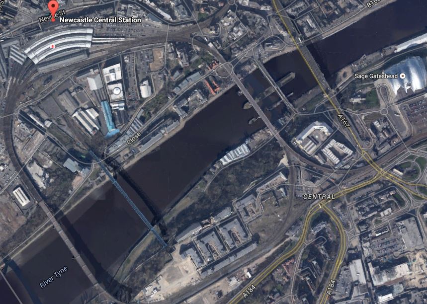
Newcastle Station
It is high above the Tyne on the edge of the city centre and uniquely the station is on a curve. It must be a very difficult to add extra tracks and platforms, which seem to be needed, as both through and local services are going to increase significantly.
I have only given five major examples, but they show how stations are becoming the focus of development.
One of my manual searches on the Internet picked up this article on Modern Railways entitled Snow Hill ‘transformation’ plan. This is the first paragraph.
Birmingham City Council has released its Snow Hill Masterplan, which outlines plans to grow the business district surrounding the station and includes proposals for the ‘transformation’ of the station into a transport hub.
Snow Hill is Birmingham’s station that is ignored by visitors from around the country, although it is important for commuters and others brought into the city on the Snow Hill Lines.
The Snow Hill Masterplan is here on the Birmingham Post website. Some of those who have commented don’t like it and they could be right. But the principles behind the plan of creating high quality offices, retail and apartments over a well-connected station is one that has been proven to work at Canary Wharf. After all it does actually make double use of the same piece of land. This is a Google Earth image of the Birmingham Snow station and its location.

Birmingham Snow Hill
You don’t see much of the actual station, as it is covered by a multi-story car park. As someone who can’t drive and manages well without a car, I can’t see why cities don’t do what London, Cambridge and Oxford have done and discourage people from driving in by providing top quality public transport.
The Snow Hill Masterplan would need an updated Midland Metro and also extra trains and routes through Snow Hill station.
I think that if I could get trains direct from Marylebone to Snow Hill, then that would be my preferred way of going. Snow Hill is in a much friendlier and welcoming part of the City than New Street.
I think on balance it is a good plan.
No comments yet.

Leave a comment