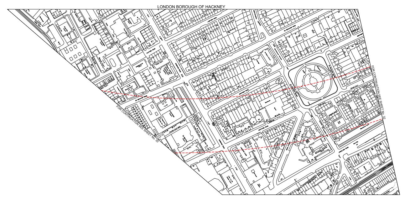
Crossrail 2 Under De Beauvoir Town
Crossrail 2 will go under De Beauvoir Town on its route through East London. This map from the Crossrail 2 web site shows the safeguarded area around De Beauvoir Square.
Crossrail 2 In De Beauvoir Town
The safeguarded area is shown with a red border. As with most of these maps, I’m posting, north is to the right and east is to the bottom. Hopefully, TfL will post some better and more understandable maps soon.
Crossrail 2 certainly won’t affect me, if I’m still around, as I live to the north-west of the square.
But as I explained in this post about Crossrail 2 At Dalston, the line will have to go deep to get under High Speed One, so I suspect that noise and vibration during construction and operation will be no worse than that line. I haven’t stood over High Speed One and tried to experience the trains, but does anybody know if they can heard or felt from above?
Incidentally, I can’t find any reports on the Internet about any problems.
As I also believe that stations will be built from the tunnel up, with all spoil being taken out through the tunnel and that as there seem to be no proposals to build any access shafts in the Dalston and De Beauvoir areas, I can see too much surface disruption being a problem.
To help matters there seems to be no plans to create massive stations as at Moorgate, Bond Street and Tottenham Court Road on Crossrail.
Hopefully Crossrail 2 will be a London’s first stealth railway!
Crossrail 2 At Dalston
In a post called An Opportunity For Dalston, I looked at how a double-ended station for Crossrail 2 might connect with both Kingsland and Junction stations. I felt it could bring major advantages to the area of not requiring any demolition, except for the unloved Kingsland station, much better interchange for passengers and improved pedestrians routes in the area.
I concluded that all was possible because the Victorians spaced the stations to enable a modern Crossrail station to fit in between. This map from the Crossrail 2 web site, shows the two stations and the safeguarded area.

Crossrail 2 In Dalston
The rail line at the far right or north is the North London Line with High Speed One beneath. The safeguarded area would appear to follow the Kingland High Road, but it does pass close to both stations.
I just thought it was logical and never envisaged that those working on the project would entertain a similar idea. But after contacting my MP, I have received a letter from Michele Dix, who is the Managing Director of Crossrail 2. This is a paragraph.
We have been working closely with the London borough of Hackney on the early development of the proposals for how Crossrail 2 could ultimately serve Dalston. The work to date has been based around delivering a double-ended station, with one end being at Dalston Junction, and the other at Dalston Kingsland, thereby allowing the Crossrail 2 station to link to both existing stations. As Mr. Miller rightly points out, the distance between the existing stations is well suited to the 250m long platforms that will be required for the Crossrail 2 station, and the greater interchange opportunities to London Overground services also deliver significant benefits.
Various factors will also drive the design of the Crossrail 2 station and the related Dalston Kingsland station at Dalston.
1. Crossrail 2 will have to get past and probably under High Speed One and the Dalston Curve, that takes the East London Line to Canonbury and Highbury and Islington. So it will be a deep line, where any stations will need escalators and/or lifts. These stations will also probably be built from the tunnel up, as parts of Whitechapel station are being built for Crossrail.
2. Could Dalston Kingsland station be designed as a station with entrances on both sides of Kingsland High Street, perhaps with a single island platform served by escalators and lifts?
3. Demolition of any quality buildings will stir up a lot of opposition.
4. There isn’t many places to put a work site, with the possible exception of the Car Park in Bentley Road which is in the safeguarded area.
5.Surely the Ridley Road market could be improved by good design of the new stations.
I think there is a chance for a good architect with a bit of vision to create an innovative world class station.
Perhaps, we need our own versions of these distinctive fosteritos to access the Crossrail 2 station from the surface.


These were designed by Sir Norman Foster for the Bilbao Metro. Hence the name!
I also think that if the design is right, Crossrail 2 can sneak its way through Dalston, with little disruption and no demolition of a building worth saving.,
Why shouldn’t us plebs in Dalston have the best?
The Crossrail 2 Junction Under Stamford Hill
The two northern branches of Crossrail 2, that go to New Southgate and Tottenham Hale respectively, would appear according to this safeguarding map on the Crossrail 2 web site, to join together under Stamford Hill.
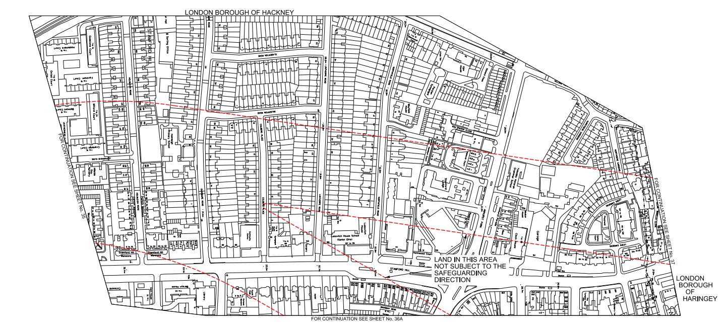
Crossrail 2 Northern Junction
This map is as it is presented on the Crossrail 2 web site, with north to the right and east to the bottom.
It looks like the junction will be in the area of Holmleigh Primary School. From the safeguarded area shown in red, it would appear that the New Southgate branch lines up north-south with the A10 road and the Tottenham Hale branch comes in from the north-east.
When the tunnels for Crossrail were built, a similar junction was needed to be built in Stepney. They obtained the access they needed by taking over part of Stepney City Farm. The work is described in a section in the Wikipedia entry.
In 2010 Crossrail took over approximately a third of the Farm’s site as part of the works to build a rail transport link connecting east and west London.[1] A map of the works as it affects the farm can be found in the annual report for Stepney City Farm Ltd from 2010_11(p. 6). This work is due to end in 2016 when the land will be returned to the farm. In January 2011 Crossrail opened up an archaeological dig at the construction site on the farm. A ventilation shaft next door to the farm leads down to the one of the largest mined caverns in Europe. In mitigation Crossrail worked closely with the farm to allow the existing animals to remain by making major improvements to the farm, especially the drainage of the fields and building a large barn for over-wintering the animals and a rural arts building to house the farm’s craftspeople
I visited in 2012 and was impressed at the good relationship between both sides.
So will a similar surface reconstruction be done with Holmleigh Primary School?
There may also be an alternative, in that the junction is just over a kilometre from the tunnel portal south of Tottenham Hale. So could a tunnel be dug from the portal and the cavern for the junction be excavated without digging down from the surface? The New Southgate branch would then go straight through the cavern on its way to Dalston, Islington and beyond.
I’m no tunnelling expert, but surely instead of digging down to create the cavern, digging in from the side is not that different.
I do think though, that the junction has been arranged deliberately under Stamford Hill, which will surely mean it is deeper underground than it otherwise would be. This must reduce any noise and vibration at the surface.
Remember too, that High Speed One was dug through this area a mile or so to the south. Wikipedia describes the digging of the tunnels like this.
The twin tunnels bored under London were driven from Stratford westwards towards St Pancras, eastwards towards Dagenham and from Dagenham westwards to connect with the tunnel from Stratford. The tunnel boring machines were 120 metres long and weighed 1,100 tonnes. The depth of the tunnels varies from 24 metres to 50 metres.
So the engineers will only probably be repeating something that was completed in 2007. But now they are more experienced and the machines are probably larger and more powerful.
It would be a major difference in the disruption caused by Crossrail 2 compared to Crossrail, if the line could be bored through Stamford Hill without any large construction shafts having to be dug from the surface.
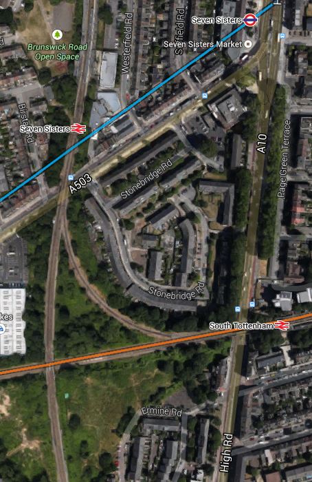
Crossrail 2 At South Tottenham/Seven Sisters
In this post, I speculated that South Tottenham and Seven Sisters stations could share a double-ended Crossrail 2 station. This is a map taken from the Crossrail 2 web site.
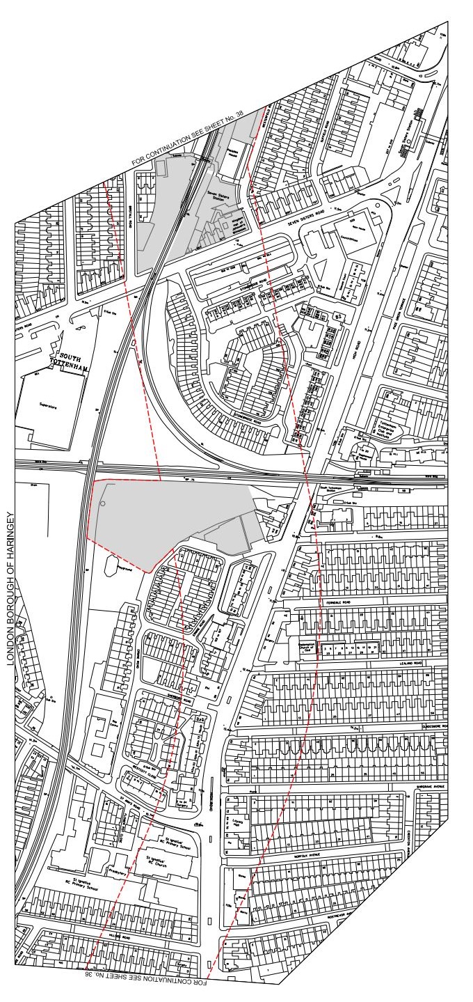
Crossrail 2 At Seven Sisters
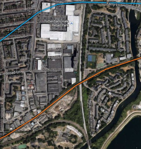
The two rail lines are the Gospel Oak to Barking Line (GOBlin) going across the map and the Lea Valley Line into Liverpool Street via Hackney Downs going down. This Google Earth image gives another view.
South Tottenham And Seven Sisters
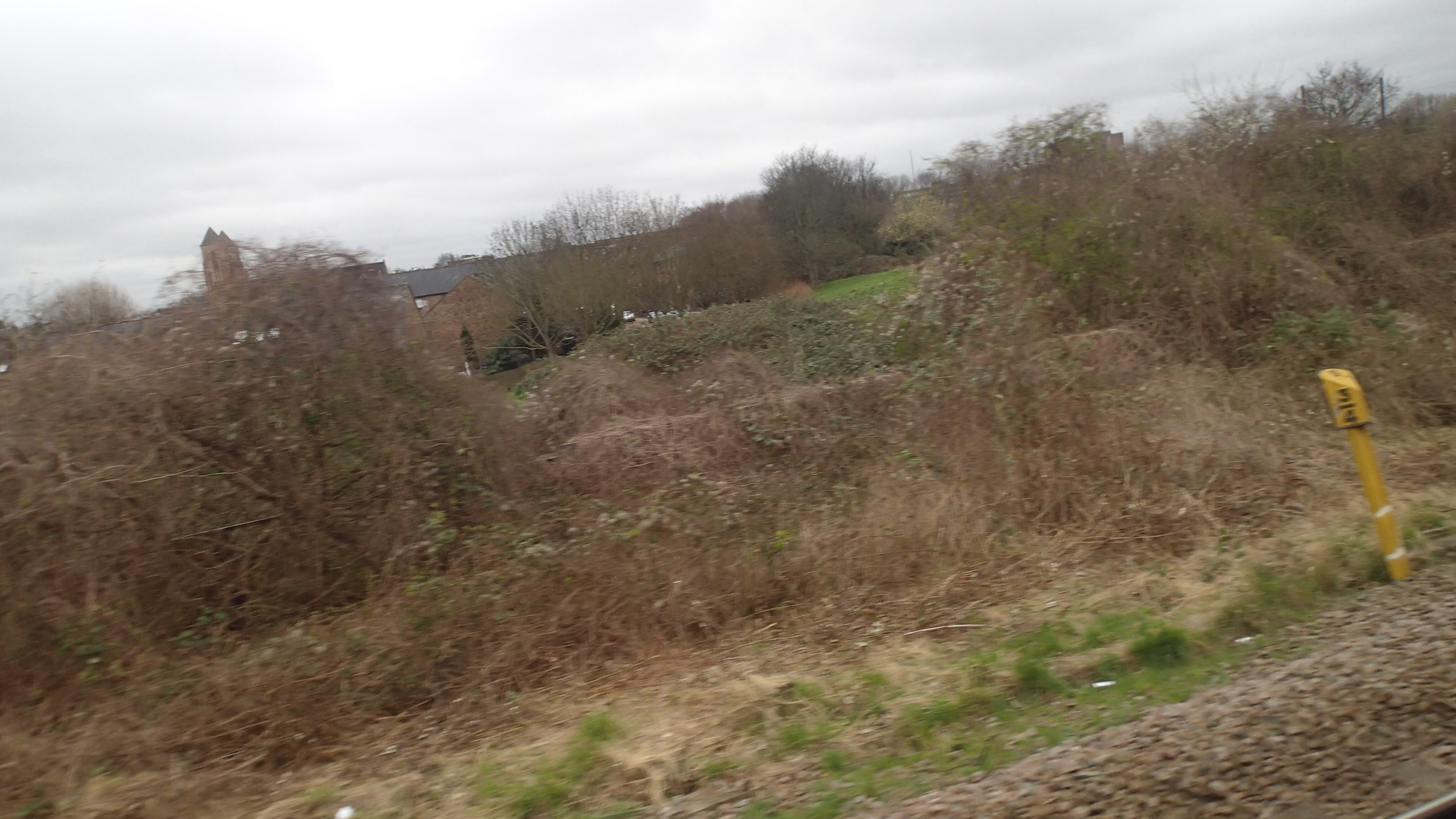
The orange line is the GOBlin and the blue one is the Victoria Line. Note the area south of the GOBlin, which has been safeguarded. Could this be used for a shaft to access the tunnels or help to build a large double-ended station? I took this picture of the area from a train going to Barking.
Safeguarded For Crossrail 2
It would probably be in a better state after Crossrail 2 had reinstated the land after use.
At least the distance between Seven Sisters and South Tottenham stations at about two hundred metres or so, would be pretty compatible with the length and size of a Crossrail-sized train and platforms.
So I come to the conclusion, that Seven Sisters station will built as a double-ended station and be a major interchange between London Overground ‘s Gospel Oak to Barking and Lea Valley Lines, the Victoria Line, Crossrail 2 and National Rail services. Such an interchange will support major development in a part of London, that desperately needs more housing, jobs and leisure and business opportunities.
Crossrail 2 At Tottenham Hale
As regards Tottenham Hale this has been said recently.
A new tunnel entrance south of Tottenham Hale station to take the line from above to below ground
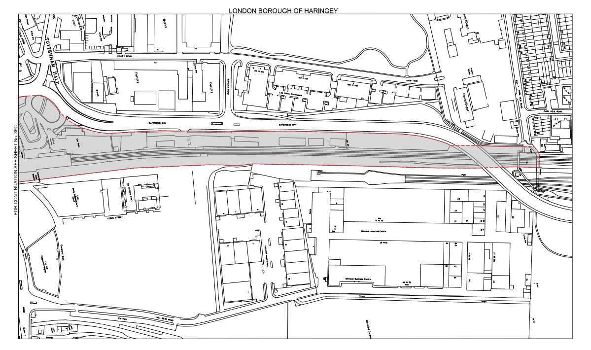
This is Crossrail 2‘s map of the area, which I obtained from this page on the Crossrail 2 web site.
Crossrail 2 At Tottenham Hale
Tottenham Hale station is at the top of the map and the Lea Valley Line to Liverpool Street and Stratford goes down the map. The other railway going across the map is the Gospel Oak to Barking Line. Note the curve that makes a triangular junction that encloses a large amount of safeguarded land, which is shaded and bounded in red. This is a Google Earth image of the area south of Tottenham Hale station.
South Of Tottenham Hale
I’ve tried rather badly to match the two maps, but it does show that there would appear to be enough space to fit a tunnel portal into the area. This is a detailed look from Google Earth of the eastern end of the land enclosed by the triangle of lines.
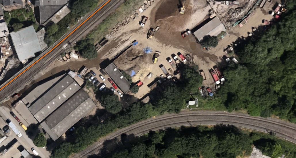
Industrial Land At Tottenham Hale
As the safeguarded route moves away to the west from here to join the New Southgate branch of the line, it is probably in this downmarket industrial area which appears to be a depot of some sort, that the Crossrail 2 tunnels will emerge. I actually put up a post entitled Could This Be Where Crossrail 2 Is Dug?, which shows this area.
As a site from where to build the tunnels, it has a lot to recommend it.
1. It is well served by railways and the River Lee and the related substantial canal, so it would be unlikely that there would be many heavy lorries associated with the construction.
2. There is little housing in the area and it would appear few or even none will be needed to be demolished for the construction. The only sensitive area would possibly be Markfield Park with the recreational developments and steam engine by the River.
3. There is plenty of space to create a surface junction with perhaps a flyover for operational reasons to connect to the Lea Valley Lines. On the other hand, the tunnels may turn north underground and just emerge alongside the Lea Valley Lines.
4. Perhaps crucially though, Tottenham Hale station, the Tottenham Hale Retail Park and the surrounding area are the subject of a big development to create almost a new town centre in South Tottenham, which I talked about in this post. I doubt this development will not be built to be totally Crossrail 2 ready.
Looking at these maps in detail, I can’t help feeling that in a few years time, there will be something special in this area, given that Thames Water and Waltham Forest Council are developing the reservoirs to the south-east of Tottenham Hale station into the Walthamstow Wetlands.
Some maps have shown Crossrail 2 surfacing north of Tottenham Hale station. This Google Earth image shows the area.
North Of Tottenham Hale Station
The strange structure underneath the lines through the station is the tunnel portal for the Victoria Line, where trains go to and from the Northumberland Park Depot.
I think the image shows why the Crossrail 2 tunnel portal can’t be north of the station.
