Two Bus Stops On High Holborn
I went to visit one of my investments on Fetter Lane and I knew that if I could find the stop I could get a 341 bus from the area to Islington or my home.
There were two bus-stops and I knew I was on the right side of the road.
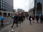
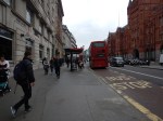
But which one do I go to? I had to walk to both of them to find the answer.
I don’t show it in the pictures, but there was a street sign between the two stops.
Wouldn’t it be nice to have a finger post to tell you where the stops are for various buses?
High Holborn is also one of those places, where there aren’t enough crossings.
Does London need a reporting system for poor street layouts or an army of elderly/disabled/teenage street walkers to collect possible simple improvements to the walking realm in the city?

If I zoom in on Google maps on my phone, it will show bus stops and if touched which services stop there. Similar on IE11. As it happens it appears that the “Holborn Circus Fetter Lane (J) Stop ID: 54419” on the north side of Holborn is the only stop served by the 341 and then [oddly] towards Waterloo. You can verify this by blowing up the bus stop sign on Streetview. Next buses at 10:37 & 10:45 according to Google.
Can’t identify the other way 😦
Comment by Mark Clayton | March 22, 2016 |
Correction, you can street view from the other side of Holborn too and the stop opposite also has 341 on it.
https://www.google.co.uk/maps/@51.517867,-0.109232,3a,15y,239.35h,90.83t/data=!3m6!1e1!3m4!1spqq0EHhpTHsdNQp2mCLQMQ!2e0!7i13312!8i6656!6m1!1e1?hl=en-GB
Comment by Mark Clayton | March 22, 2016 |