Superloop – Will It Be The North Circular Road Most Of The Way Between Harrow And Royal Docks?
This draft map from TfL illustrates the concept of Superloop.
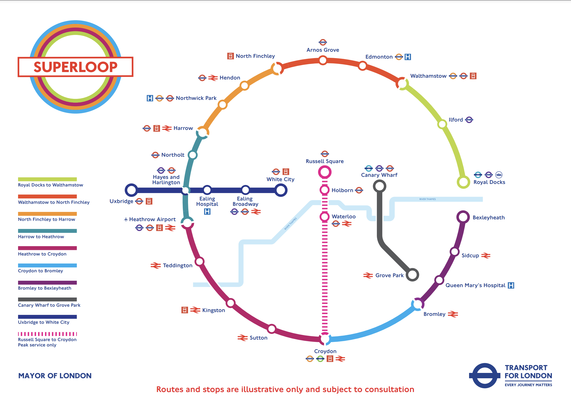
In this post I am considering the section of the the North Circular Road (A406) between the Hangar Lane Gyratory System, where it crosses the A40 in the West and the roundabout , where it crosses the A13 at Beckton in the East.
- This section is a grade-separated dual-carriageway all of the way between Hangar Lane and Beckton.
- Hendon, North Finchley, Arnos Grove, Edmonton, Walthamstow, Ilford and Royal Docks are not far from the A406.
- Several bus routes already run on the A406.
The large Brent Cross Shopping Centre is also just outside the A406 and a new Brent Cross West station will be opening soon.
I’ll now look at the three Northern and North-Eastern sections.
Harrow And North Finchley
This section is shown in orange.
- It calls at Northwick Park hospital and Hendon. both have rail connections.
- Brent Cross Shopping Centre could be on the route, if the A406 is used.
- London Bus 182 runs between Harrow bus station and Brent Cross Shopping Centre via Northwick Park hospital.
Could the 182 bus be extended to North Finchley, where there is a new bus station?
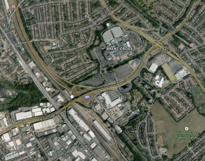
This Google Map shows the stations around the Brent Cross Shopping Centre.
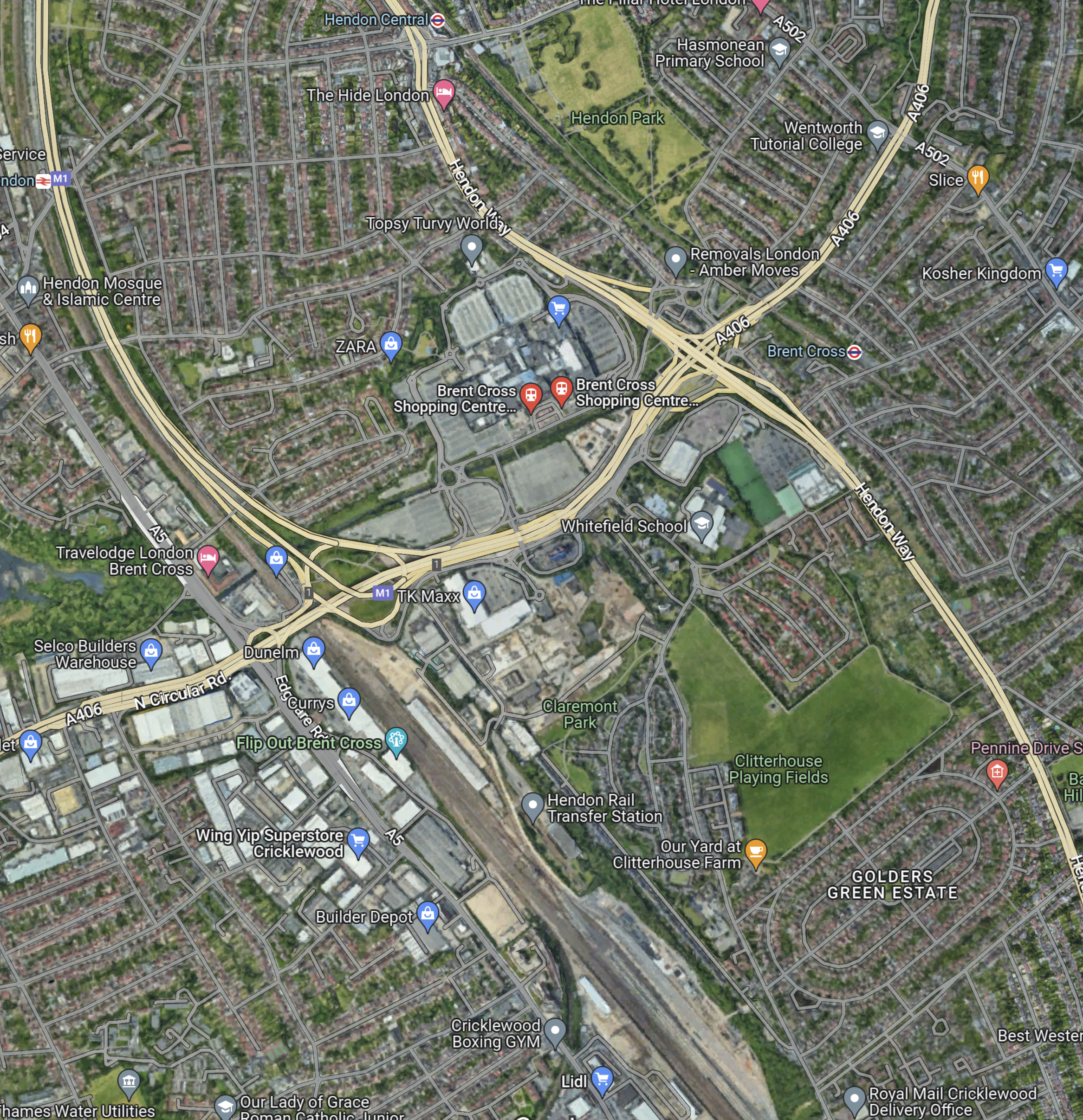
Note.
- The railway running between the North-West corner of the map and the bottom of the map is the Midland Main Line.
- The road running between the North-East corner of the map and the left of the map is the North Circular Road.
- The road running down the right hand side of the railway is the M1, which joins the A406 in the large junction.
- The other major road to the right of the map, is the Hendon Way.
- The station in the North-West corner of the map is Hendon.
- The station being built in the bottom of the map on the Midland Main Line, is the new Brent Cross West station.
- The station in the North-East corner of the map is Brent Cross on the Northern Line.
I am certain that a Superloop bus could run from Harrow bus station and Northwick Park hospital, and visit the required number of the stations around the Shopping Centre, before trundling on to the new North Finchley bus station for some refreshment before returning to Harrow.
I feel that the Superloop bus could use the North Circular Road from the shopping centre and then turn North on to Finchley High Road (A 1000).
North Finchley And Walthamstow
This section is shown in red.
- It calls at Arnos Grove and Edmonton.
- London Bus 34 runs between Walthamstow bus station and Barnet. It runs for some of the way along the North Circular Road and passes Arnos Grove, Silver Street and the North Middlesex Hospital.
I am certain, that a Superloop bus could run between Walthamstow bus station and North Finchley, using a similar route to the 34.
Walthamstow And Royal Docks
This section is shown in lime.
- It calls at Ilford for the Elizabeth Line.
I am certain, that a Superloop bus could run between Walthamstow bus station and Royal Docks, using a the A406 and the A13.
Conclusion
After this simple analysis, it looks possible to use the use the North Circular Road between Harrow and Royal Docks.
Funding For Homes And A New Railway Station In North London
The title of this post is the same as that of this article on Ian Visits.
The government has said, that two major housing developments will be built in London beside new railway stations.
Brent Cross Thameslink
The development and the funding for Brent Cross West station is introduced by this paragraph.
The larger investment will see £320 million being spent on a new Brent Cross West Thameslink station which will lead to a new community of 7,500 properties being built. This is in addition to the £97m grant awarded in the 2016 budget bringing total government investment £416.5 million.
Other points about the development include.
- The development is on the site of the Cricklewood depot.
- The station could be asn interchange with the West London Orbital Railway.
- A contractor should be appointed this year, with opeing in 2022.
- Services could be eight trains per hour (tph) in the Peak and four tph in the Off Peak.
- A public bridge over the railway will be included.
- There will be new offices.
- The Brent Cross Shopping Centre will be extended.
- The £320 million investment will be repaid from business rates from the commercial development.
It all seems to me, that there could be a lot of winners here.
Old Oak Common
The development and the funding for Old Oak Common station is described by this paragraph.
The government will also be providing £250 million so up to 13,000 new homes can be built close to the new HS2 railway station at Old Oak Common.
This scheme provides more properties, but it doesn’t as yet include the commercial development.
Conclusion
London seems to be building more housing, that at any time in my life.
Lines Through Hampstead And Harringay
This map from carto.metro.free.fr shows the layout of railway lines through Hampstead.

Lines Through Hampstead
I believe that it is a network that will be changed dramatically in the next few years.
In the west of the map, there is a triangular junction to the north of Cricklewood station, which connects the Dudding Hill Line to the Midland Main Line.
Also to the North of Cricklewood station is the old Cricklewood TMD (traction maintenance depot), which is now being developed as Brent Cross Cricklewood with houses, oficces, an extension to the Brent Cross Shopping Centre and a new station called Brent Cross Thameslink.
In the east of the map, Gospel Oak station is prominent and if you take a close look you can see how a double track spur connects the Gospel Oak to Barking Line (GOBlin) at Junction Road Junction to the Midland Main Line at Carlton Road Junction. This short length of line, which is used by freight trains, is also being electrified, so that freight trains can be electric-hauled from Barking and then up the Midland Main Line.
From Carlton Road Junction, freight trains can sneak up the western side of the Midland Main Line and either go North to freight depots like the proposed Radlett or take the Dudding Hill Line to connect with the West Coast Main Line or the Great Western Main Line. You can see the tracks that freight trains would use is this image taken looking south from the bridge at West Hampstead Thameslink station.

Lines Through West Hampstead Thameslink Station
The tracks that freight trains will use are to the far right.
Transport for London’s Transport Plan for 2050 talks about improving the Overground, by using existing lines to create a circular railway based on the GOBlin. It could be routed via the Dudding Hill Line to Hounslow.
Looking at the above image, it would appear that it could be fairly easy for trains from the GOBlin to stop at West Hampstead Thameslink on their way to the Dudding Hill Line. This Google Map shows the station.

West Hampstead Thameslink Station
It would appear that there may even be space for an island platform, but I suspect a bi-directional platform sharing with the current Platform 4, will be much easier to create and more affordable.
The extended GOBlin would then call at Cricklewood station, from where it could either go straight down the Dudding Hill Line or perhaps via a reverse at the new Brent Cross Thameslink station.
This Google Map shows the area between Brent Cross and the Midland Main Line.
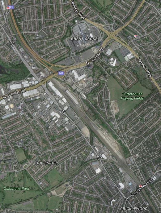
Brent Cross
Note the large area of the current Cricklewood TMD to the North East of the triangular junction with Cricklewood station south of the area. The development will be partly on the northern part of the TMD.
The advantage of the indirect route, would be that the Shopping Centre and all the new development in the area, gets good connections from Hounslow and Acton in the West to Holloway, Tottenham and Walthamstow in the East.
If the trains run at the current four trains per hour of the GOBlin, then this line would be a valuable link across North London connecting to the Midland Main Line and Thameslink at either Brent Cross or West Hampstead stations.
It is an interesting proposition.
But it might get even better!
London’s two big problems are housing and transport, so look sat this Google Map of the area to the East of Gospel Oak station.

A Site To The East Of Gospel Oak Station
There is a large site around the triangular junction formed by the GOBlin in the North, the Midland Main Line in the South and the link between the two lines in the East.
It could be used for much-needed housing and other developments in the future. At the present time, it is owned by J. Murphy and Sons, who by chance are the contractors working on the electrification of the GOBlin.
Look at the map and I think that there is enough space to put a new station on the eastern side of junction.
So trains from Upper Holloway station to the Dudding Hill Line could go through.
- Junction Road if that station is built.
- Murphy’s Town
- West Hampstead Thameslink
- Cricklewood
- Brent Cross Thameslink
I think that some of the out-of-the-box-thinkers at Transport for London will come up with some extensive knitting in North London.
Look at this Google Map, which shows the GOBlin through Harringay.
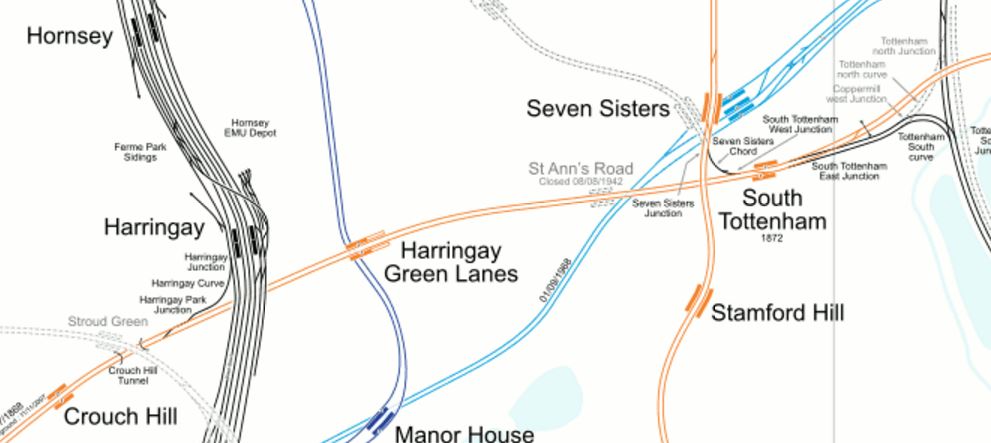
Lines Through Harringay
The GOBlin is or could be very well connected.
- The connection to the East Coast Main Line is being electrified.
- Harringay Green Lanes station sits on top the Piccadilly Line.
- Seven Sisters station will be connected to South Tottenham station by Crossrail 2.
- It is linked to the Lea Valley Lines south of Tottenham Hale station.
Who knows what Transport for London will do with the GOBlin?
I wonder if in conversations in the pub near TfL’s offices, they wish that they still had the Palace Gates Line to play with. You can see it’s line on the map above as it goes away to the North West from Seven Sisters station.
I do find it strange however, that the route of Crossrail 2 from Seven Sisters to New Southgate, very much follows the route of the Palace Gates Line.
So can we assume, that the Victorians got that one right too?
Will Brent Cross Thameslink Station Get The Go-Ahead?
This was said in this article in the Standard last night.
At the same time, the Chancellor is promising a £97 million downpayment for a new station at Brent Cross, a major redevelopment area highlighted in his National Infrastructure Plan with last December’s Autumn Statement. It could help start construction of 7,500 homes. Another £7 million will go to the Croydon growth zone, aiming to create 4,000 homes. A further £1 million will fund the new London Land Commission to help create a “Domesday Book” of surplus public-sector land and brownfield sites for redevelopment.
London desperately needs more housing and building it around the Shopping Centre and a new Brent Cross Thameslink station at Brent Cross, astride the North Circular Road on surplus railway land must be a good idea.
This is a Google Earth image of the area.
Brent Cross
The Midland Main Line on which the station will be built runs north-south at the western edge of the image, with Hendon station just visible at the top beside the M1.
The Shopping Centre is clearly marked and the A41 passes beside it towards the east.
The whole area is dominated by the roads and flyovers of the M1, A5, A41 and North Circular Road, which are choked with traffic. As the developers of the new Brent Cross Cricklewood development are spending £4.5 billion over the next twenty years and have stated they are improving the roads and other transport links in the area, together with creating four new parks, could we see all of these roads either buried in tunnels or more likely roofed over so that all traffic is put out of sight and mind?
According to the development web site, one of first things being done is this.
Renew and revive Clitterhouse Playing Fields and Claremont Park creating two beautiful community parks, as well as starting to create Brent Riverside Park.
Let’s hope this defines how they mean to carry on. Clitterhouse Playing Fields are at the south-east corner of the Google image.
The developers and their architects could have great fun with this development.
Looking at the position of the station, one place to put it could be where the Midland Main Line crosses the North Circular Road in an echo of how Blackfriars station was recently rebuilt over the Thames.
I can see in my mind, a shining glass palace with a roof garden above the roads with an enormous red rail sign, saying “I’m Brent Cross Thameslink, Ride Me!”
It would be the signature for the whole development.
The new station would also be a major interchange where passengers to and from the East Midlands and South Yorkshire changed between the new electric trains on the Midland Main Line and London’s rail system.
