Looking At The East West Railway Between Bedford And Cambridge
Updated Post
I have updated this post in June 2021 to add extra information, that has now become available.
The route that has been chosen by East West Railway is Route E.
Route E is described in Wikipedia as follows.
Route E involves running from the existing Bedford station heading north then running to Tempsford where a new station would be built then (bypassing Sandy) the route heads east to Cambourne where a new station would be built. The route then joins an existing line northbound to Cambridge.
These maps show the route between Bedford and Cambridge stations in sections.
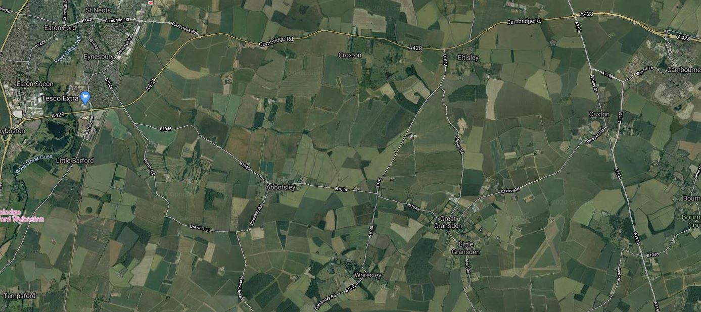
Bedford And Tempsford
This map shows the Western section between Bedford and Tempsford.
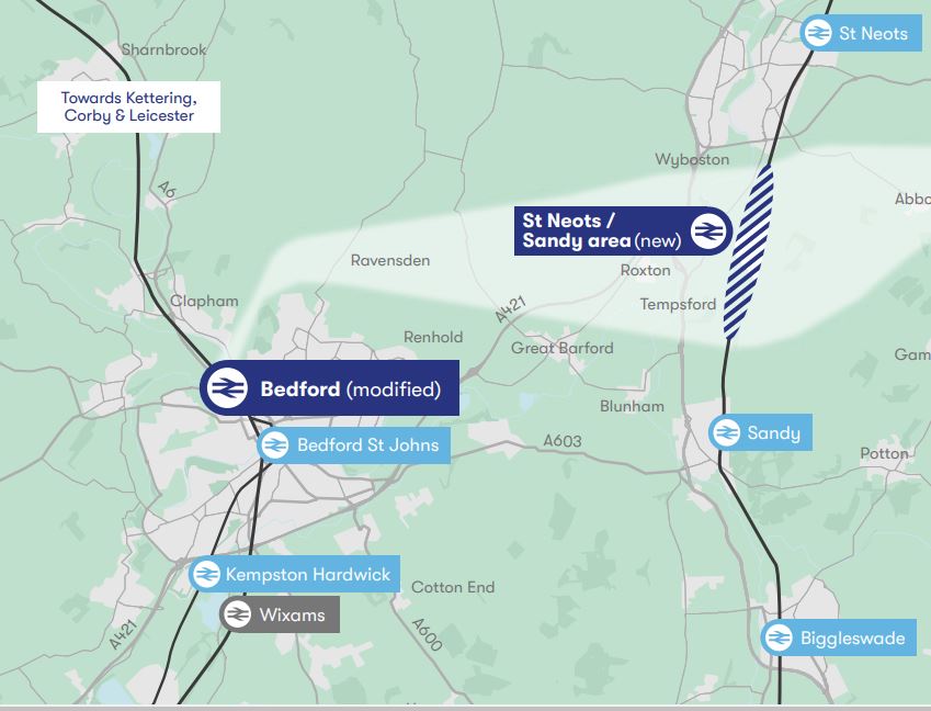
Note.
- Kempston Hardwick and Bedford St. Johns are existing stations on the existing Marston Vale Line, which could substantially be the route of the East West Railway between Bedford and stations to the West like Bletchley, Milton Keynes, Oxford and Reading.
- Bedford station is on the Midland Main Line.
- Wixams station is a proposed station on the Midland Main Line, which also might be served by the East West Railway.
- Biggleswade, Sandy and St. Neots stations are on the East Coast Main Line (ECML).
I’ll now take a quick look at the route through Bedford and the proposed Wixams station.
Bedford Station
Bedford station is served by the following train services.
- It is a terminus for Marston Vale Line services to and from Bletchley station.
- It is a terminus for Thameslink services to and from London St. Pancras International station and the South as far as Brighton.
- East Midlands Railway services between London St. Pancras International station and the East Midlands and Sheffield call at the station.
Midlands Connect are also proposing a service between Bedford and Leeds.
- It would use High Speed Two Classic-Compatible trains.
- This would use High Speed Two to the North of East Midlands Hub station.
- Times would drop between Bedford and Leeds from 140 minutes to 66 minutes.
I wonder, if this service were to be successful, that more services could be run from Bedford to the North.
There would certainly be massive advantages in developing Bedford as a major interchange between the East West Railway and the Midland Main Line.
This Google Map shows Bedford station.
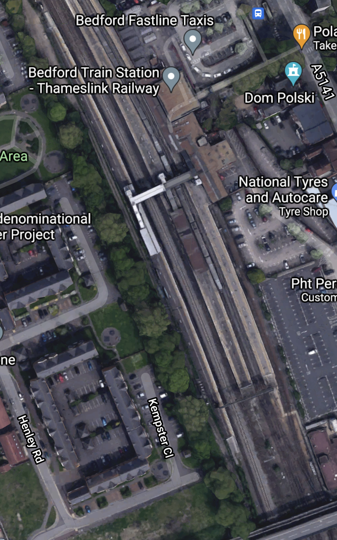
Bedford station currently has five platforms.
- 1a – A bay platform for Marston Vale Line services
- 1 and 2 – Thameslink
- 3 – Southbound East Midlands Railway
- 4 – Northbound East Midlands Railway
Note.
- Platform 1a is about a hundred metres long.
- There is a fast line between Platforms 3 and 4.
- There is space to the West of Platform 4
I can come to these conclusions about Bedford station.
If a new platform is needed to handle more services at the station, there is space to build it.
According to East West Railway Company To Start Second Phase Of Rolling Stock Procurement, three-car trains are to be used by the East West Railway and these can be handled by the current Platform 1a.
As Bedford station is to be rebuilt, any issues can be sorted.
This Google Map shows the area to the North of the station.
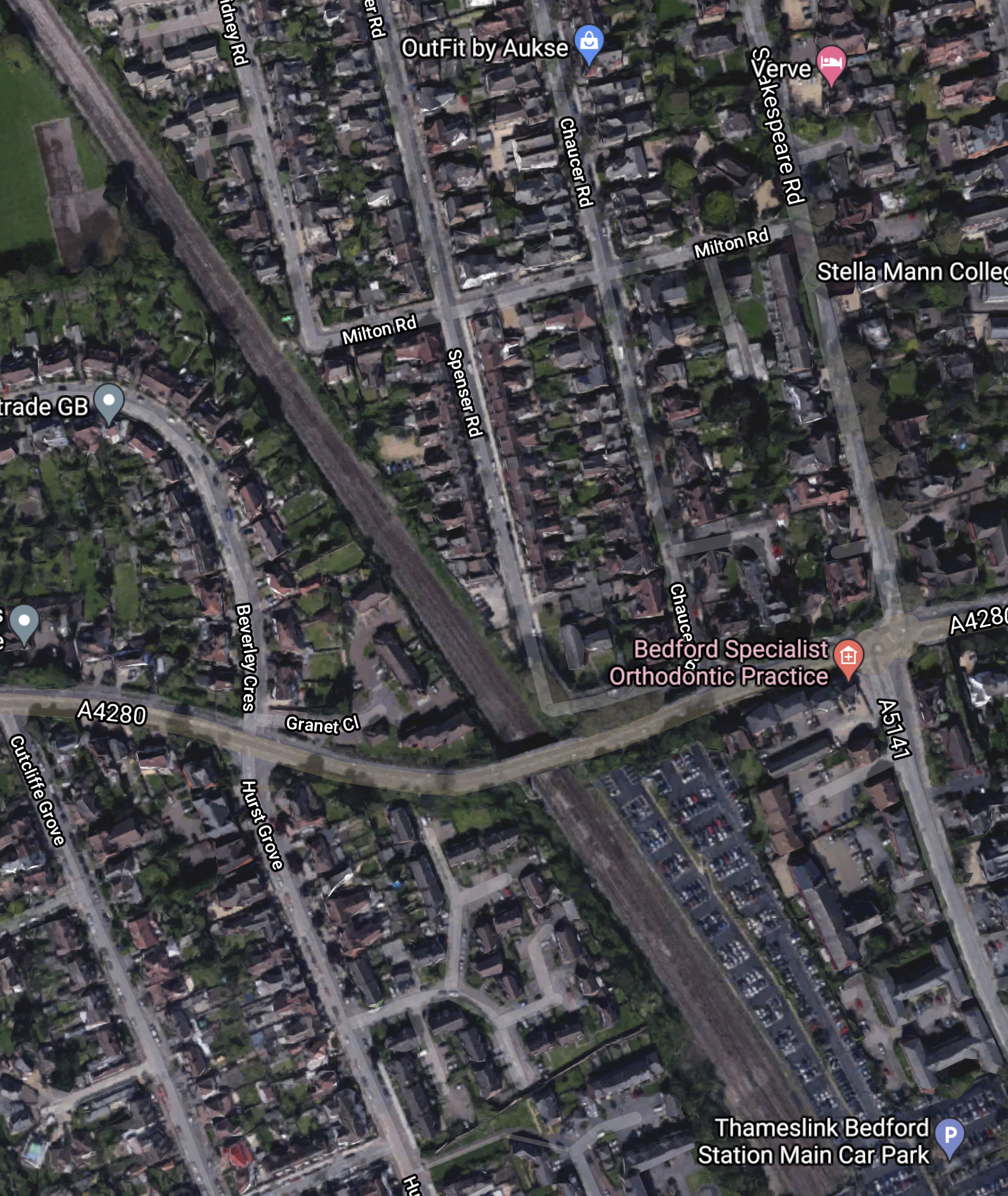
Note that some of the roads to the North-East of the railway are named after poets. This is the Poets area of Bedford.
This article on the BBC is entitled East-West Rail: Bedfordshire Residents Give Their Views On £5bn Scheme and it details the opposition to the route including a section about the Poets area.
EWR Co says it could acquire or demolish 53 properties in the Bromham Road district of Bedford, known as the Poets area.
In addition, a further 16 properties could be demolished between Bedford and Cambridge.
This Google Map shows the Midland Main Line through Bedford.
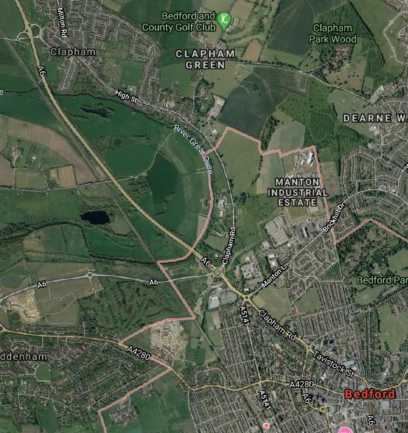
Note.
- Bedford station is at the bottom of the map towards the East.
- The village of Clapham is towards the top of the map.
- The A6 road runs up the Eastern side of the railway.
What I find interesting, is that, to the East of the Midland Main Line between Bedford and Clapham appears to be mainly open farmland.
Is there sufficient space to build a flying junction, so that trains could go between Bedford and Cambridge in a smooth manner? From a quick look at this map, it appears to me that this would be possible.
It might even be possible to build a full triangular junction, North of Bedford, so that trains could go between the East and the Northbound Midland Main Line.
It looks to me to be a very important junction, that gives lots of possibilities for new passenger and freight services.
- Passenger trains between Cambridge and Sheffield via Leicester and Derby.
- Freight trains between Felixstowe and Derby, Nottingham and Sheffield.
- Could the route be used for stone trains between the Peak District and the massive building developments in the City of London?
This ideas would be for starters!
But I do feel that Network Rail have lots of strong reasons to take a North-Easterly route out of Bedford.
But this route is not popular with those that live in the area.
This Google Map shows the area South of Bedford towards the Wixams development.
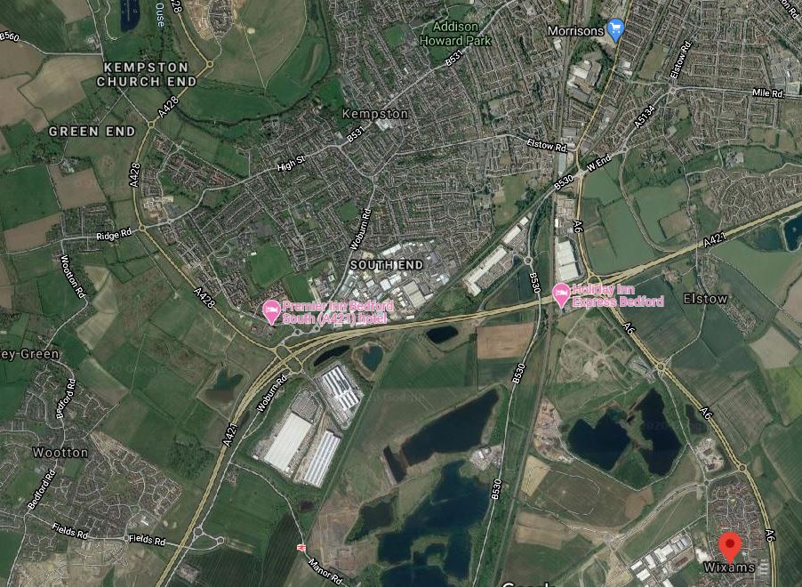
Note.
- The large new village of Wixams is shown by the red arrow.
- Kempston Hardwick station can be picked out to the West of Wixams, close to the bottom of the map.
- The Midland Main Line can be picked out running South between Wixams and Kempston Hardwick.
The area looks like it is ripe for housing and commercial development between all the water.
I can envisage the East West Railway and the Midland Main Line doing the following.
- Sharing tracks through Bedford and a new Wixams station, if that is desired.
- A flying junction would then allow the two routes to split.
- The East West Railway would go West to places like Bletchley, Milton Keynes, Oxford and Reading.
- The Midland Main Line would go South to Luton, London and beyond.
The East West Railway would open up a massive housing development at Wixams with connections to Cambridge, London, Milton Keynes, Oxford and beyond.
It strikes me, that one of the reasons for choosing Route E, is that this is the route, that opens up the Wixams development.
Could A Southern Route Be Used Around Bedford?
It probably could but, if the trains were to serve Bedford they’d need to reverse in Bedford station.
If the East West Railway goes to the North of Bedford, the following is possible.
- East West Railway trains going East could share Platform 4 with Northbound East Midlands Railway services.
- East West Railway trains going West could share Platform 3 with Southbound East Midlands Railway services.
- East West Railway trains going West could also have a cross-platform interchange with Thameslink.
Train operation would be much simpler.
Through Tempsford
This map shows the Western section around Tempsford, where it crosses the ECML.
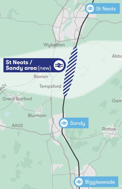
Note.
- Biggleswade, Sandy and St. Neots stations are on the ECML.
- There might be opportunities to improve the section of the ECML in this area.
- The light-coloured East-West band through the new station, is the proposed route of the East West Railway.
This Google Map shows the area North from Sandy.
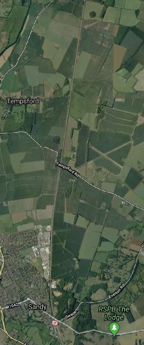
Note.
- Sandy station can be seen at the bottom of the map.
- Tempsford can be seen about three-quarters of the way up the map.
- The ECML runs North-South up the middle of the map.
- The former RAF Tempsford can also be seen on the East side of the ECML.
- One interesting place on the map is the RSPB at Sandy.
Has the route been chosen to the North of Sandy to avoid the RSPB, who might not be in favour of a new railway?
- I could envisage an impressive interchange station at Tempsford, if East West Railway decided to build it.
- The East West Railway and the ECML could cross at right angles.
- Platforms on both routes could be connected by lifts, escalators and stairs.
- There looks like there could be space for lots of car parking.
Alternatively, a full junction could be built so that trains could swap between the two routes. But I suspect this would be too expensive.
The View From St. Neots
This article on the BBC is entitled St Neots: ‘I Think This Could Put Our Town On The Map’.
This is the first paragraph.
For the first time in its 1,000 years of history, St Neots could get its own voice in Parliament as part of a reshuffle of constituency boundaries. What difference could it make for a town that is the largest in Cambridgeshire?
The This in in the title is their own MP.
This is also said about transport links in the town.
he town, which is 45 minutes to London by rail, is getting a new bypass and is also at the centre of the new Cambridge to Oxford east-west rail link.
“There are phenomenal opportunities here for new business, all this development is happening around us,” adds Mr Hughes.
“All the people who used to travel to London – because St Neots is a commuter town – during the pandemic, they’ve opened the door, walked into the town and realised there’s a wonderful bohemia here.
There are also complaints in the article about the lack of jobs.
Surely, if the new station at Tempsford was well-designed and had enough car-parking, some of those commuters could work in Cambridge.
Tempsford And Cambourne
This map shows the central section between Tempsford and Cambourne.
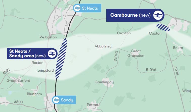
Note.
- Sandy and St. Neots stations are on the ECML.
- The light-coloured East-West band through the new Tempsford and Cambourne stations, is the proposed route of the East West Railway.
This Google Map shows the area between Tempsford and Cambourne.
Note.
- Tempsford is in the South-West corner of the map.
- Cambourne is in the North-East corner of the map.
- St. Neots station is in the North-West corner of the map.
It certainly isn’t an area of the country with many important buildings around.
Through Cambourne
This Google Map shows the central section through Cambourne.
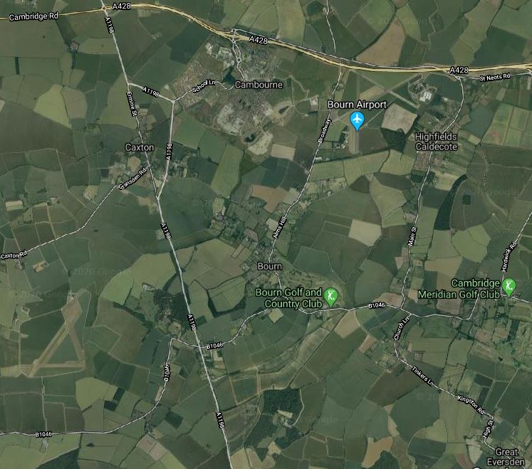
Note.
- The new village of Cambourne by the A428.
- The A1198 road going North-South between Huntingdon and Royston.
- The village of Great Eversden in the South-East corner of the map.
From looking at the various maps and knowing the area well, I suspect the East West Railway will take the following route.
- Approach from the West and cross the A1198 to the North of Caxton.
- Pass South of Cambourne, where a station could be built. The station could be fairly simple, but there is plenty of space, especially if cycling to the train is encouraged.
- Pass North of Bourn and Bourn Golf and Country Club.
- Pass North of Great Eversden and leave the map in the South-East corner.
It looks to be a fairly simple section.
Great Eversden And Cambridge
This Google Map shows the area from Great Eversden to the Trumpington Park-and-Ride, which is served by the Cambridgeshire Guided Busway.
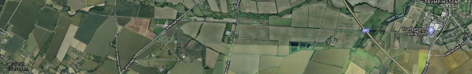
Note.
- Great Eversden is in the South-West corner of the map.
- The M11 runs diagonally across the Eastern end of the map.
- Trumpington is at the Eastern end of the map.
- The track bed of the old Varsity Line is clearly visible.
The question has to be asked, if it would be worthwhile rebuilding this section.
Consider.
- Part of the trackbed is used for the Ryle Telescope.
- Part of the trackbed is used for the Cambridgeshire Guided Busway.
- The route doesn’t serve Addenbrooke’s Hospital.
- Cambridge also has ambitions to extend the Cambridgeshire Guided Busway to Hauxton and create the Cambridge Autonomous Metro, which I wrote about in Consultation On The Cambridge Autonomous Metro.
This map shows the proposed layout of the Cambridgeshire Autonomous Metro.
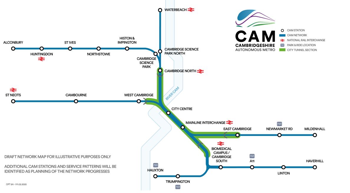
Note.
- The green section will be in tunnel.
- The Trumpington Branch is extended to Hauxton,
This Google Map shows the area to the South West of Cambridge between Hauxton and Addenbrooke’s Hospital.

Note.
- Addenbrooke’s Hospital is in the North-East corner of this map.
- The Trumpington Park-and-Ride is to the East of the M11.
- Shelford station is in the South-East corner of the map.
- The West Anglia Main Line running past the hospital, splits into two, with one branch going West to Royston and Hitchin and the other going South to Harlow and London.
The two maps taken together weave quite a complicated pattern.
The East West Railway and the Cambridge Autonomous Metro could probably be tweaked so that they could both be created.
- The East West Railway could take a slightly more Southerly route and pass to the West of Hauxton to join the Royston and Cambridge Line to get to Cambridge South and Cambridge stations.
- The Cambridge Autonomous Metro would pass over or under the M11 and terminate at a suitable place on the East of Hauxton.
There might even be a solution involving a joint station to the West of the M11

[…] Looking At The East West Railway Between Bedford And Cambridge, I came to the conclusion, that the East West Railway (EWR) and the Midland Main Line would share […]
Pingback by The Concept Of Electrification Islands « The Anonymous Widower | April 16, 2020 |
[…] Looking At The East West Railway Between Bedford And Cambridge, I looked at the route of the East West Railway as it approaches […]
Pingback by Beeching Reversal – Reopening Harston Station « The Anonymous Widower | March 21, 2021 |
Very interesting post. In many respects you would think the section between Bedford and Cambridge to be the most complicated aspect of East West Rail. Infact the section between Bletchley and Bedford, known as the Marston Vale line, is causing all sorts of problems! Somehow this section will also require 100 mph running and W10 loading gauge for freight but the current infrastructure won’t allow this. Consequently this section will be completely rebuilt as will Bedford station. Nearly all the level crossings will be clised. Options are currently open to public consultation. This hurdle needs to get overcome first before the Bedford to Cambridge section is finalised. And as you know all will be very expensive! I think it would be worth your while posting the options for the Marston Vale line it’s certainly will raise many questions in the current public consultation process.
Comment by David Sutherland | June 4, 2021 |
Thanks for that! On my list is to write a piece talking about those who are persistently wanting to go back to zero, as in those who want a Northern route into Cambridge.
I actually feel, that in places, we may not be bold enough. I grew up in Felixstowe and lived for some years to the North of Ipswich, before moving to near Newmarket, so I have lots of knowledge of that area and have been impressed by East West Rail’s plans for East of Cambridge. The use of a tram-train to create extra capacity through Ipswich is a stroke of genius, if it goes ahead.
Comment by AnonW | June 4, 2021 |
I agree the work planned for East of Cambridge is certainly interesting. I gather as part of the Cambridgeshire transport plan new stations at Cherry Hinton and Fulbourn will be reinstated. I believe there is also the intention to reinstate the double track for the section kf this line. I’m not sure though how the very tight curve leaving the junction from the Cambridge main line will be managed? Perhaps at this point it will remain a single track junction. It will be very interesting to see how this develops. Of other concern I’m sure your aware that the new Labour Mayor for Greater Cambridgeshire has cancelled the proposed autonomous metro. This is hugely significant for the region. Once again such places as Haverhill which is a fast growing town is left high and dry. The cancellation of this project must be a major concern for everyone involved. Perhaps another topic for your blog AW!
Comment by David Sutherland | June 5, 2021 |
I feel that with a bit of selective demolition and some clever signalling, that the connection of Ipswich services to Cambridge can be improved. EWR are proposing to run freight trains through Newmarket and on to the EWR. That won’t go down well in Newmarket.
I used to live just to the North of Haverhill and the Stour Valley Line would be a well-used route if it were to be reopened.
Haverhill is one of these towns where to have any standard of living you need a car. That means on leaving school, kids prefer to get a job, rather than go to University.
Cambridge is desperate for workers and with apprenticeships becoming more common, the city and University can help sort the problem, but it needs decent public transport links.
I went to Liverpool University and they are now using apprenticeships to recruit and train, the staff the University needs. According to my contact there, it’s working well. But then Liverpool has a World Class Metro backed up by lots of strategic buses and the most famous ferry in the world.
Comment by AnonW | June 5, 2021 |
Yes I believe one of the major considerations for East West Rail, apart from the obvious issues of connectivity and the proposed expansion of housing along the route, is one of freight. The line is being built to W10 loading gauge and the idea is to provide relief for other freight routes especially the North London line. As you say unfortunate perhaps for the residents of Newmarket but at least the route will be upgraded.
I also agree with your previous comments with regard to electrification. I don’t think this is a major concern not to electrify East West Rail. As suggested by you the modern turbo diesels are very efficient, also there will be more advances in battery technology and perhaps also hydrogen. There is passive provision for future electrification but I don’t think this will be needed. As it is the cost of EWR is significant as it currently stands. The section between Bicester and Bletchley currently under construction is now costing over £1 billion. The section between Bletchley and Bedford will probably be not far off the same, given the complete rebuilding of this section. Everything will need to be replaced plus new stations built. I would imagine the proposal in the public consultation to reduce the number of stations to five, thus avoiding most if not all of the passing loops, will probably go ahead. The issue of course is the slow service provided by the Viva Rail rebuilt D stock, which only has a maximum speed of 60 mph. I suspect in the final analysis this stock will be replaced with something better, simply to fit in the with EWR 100 mph service.
Comment by David Sutherland | June 5, 2021 |
I do think that the closure of this route, but one of the worst economic crimes committed in the 1960s, as Beeching recommended the route should be retained and the Varsity Route had performed so well in WW2. British Rail even put in the Bletchley flyover to make it a better route for freight.
I have done some calculations about 100 mph Hitachi battery-electric trains recently and if you put batteries in the intermediate cars instead of diesels, you can easily get a 200 mile range.
It does appear that despite having more csrs, a nine-car train has much better range than a five-car.
I would like to see battery-electric Hitachi Class 385 trains ordered for the EWR. They could charge at Reading, Bedford and Milton Keynes.
Comment by AnonW | June 5, 2021 |