Easter Disruption For Europe’s Busiest Train Line
The title of this post, is the same as that of this article on the BBC.
This is the sub-heading.
Thousands of Easter train journeys will be disrupted by a six-day shutdown on the West Coast Main Line (WCML).
These two paragraphs add more details.
Engineering work means no intercity services will run between London Euston and Milton Keynes from Good Friday to Wednesday, 8 April, Network Rail said.
The Easter work is part of a £400m project to boost reliability, which WCML said was Europe’s busiest railway line used for passenger and freight trains.
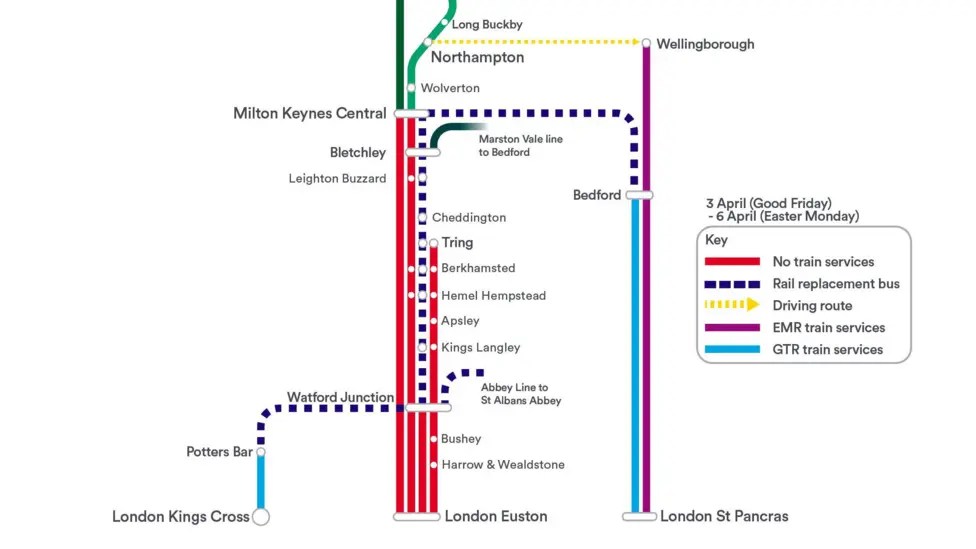
This graphic from London Northwestern Railway, shows the Rail Replacement Bus routes around the blockade.
Note.
- There are no trains South of Milton Keynes Central
- There is a Rail Replacement Bus between Milton Keynes Central and Bedford.
- There is a Rail Replacement Bus between Milton Keynes Central and Watford Junction
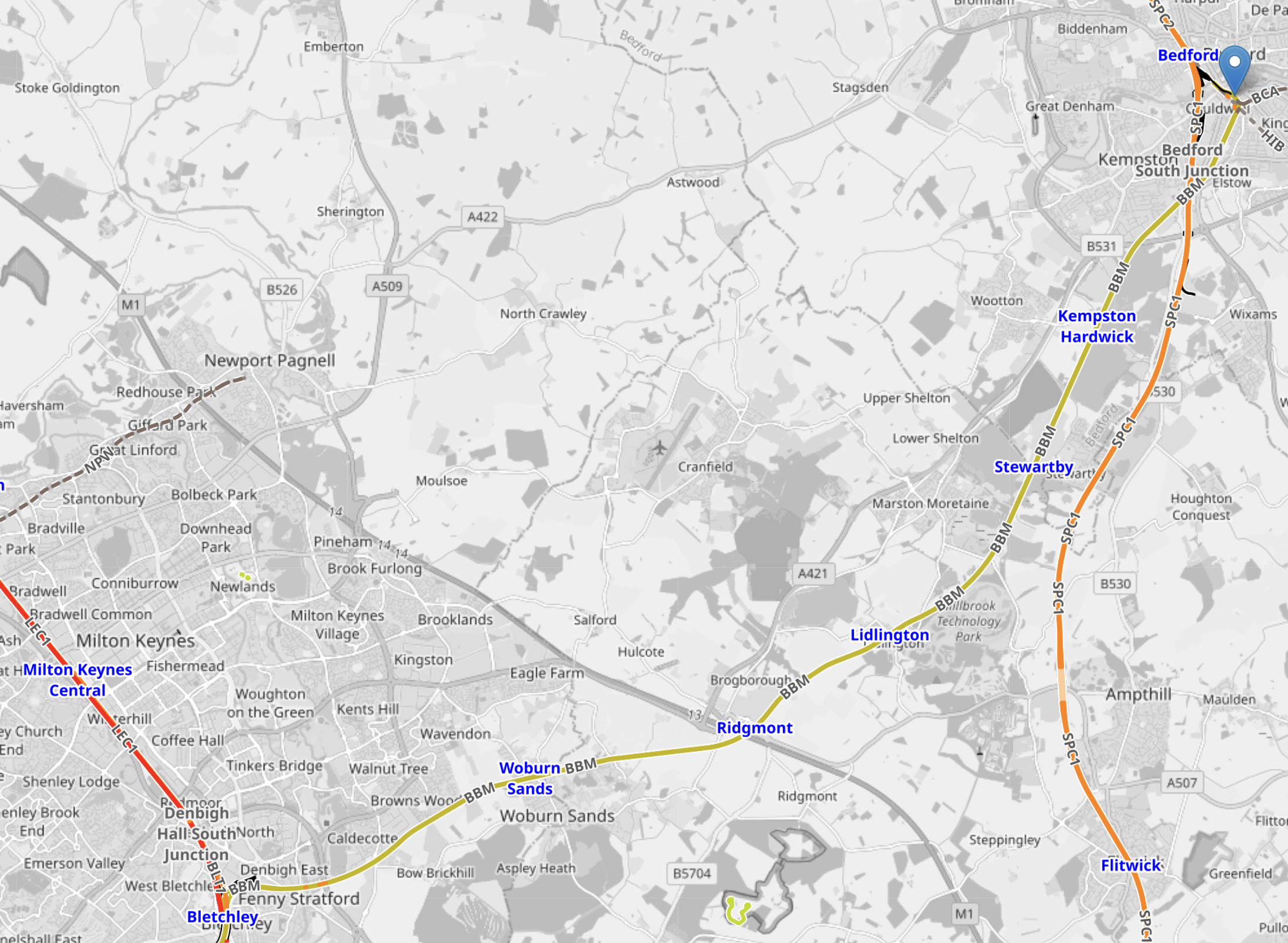
This OpenRailwayMap , shows the Marston Vale Line between Milton Keynes Central and Bedford.
Note.
- The two Bedford stations ; Bedford and Bedford St. Johns are in the North East corner of the map.
- Milton Keynes Central station is on the Western edge of the map.
- The Marston Vale Line, which is shown in yellow, links Milton Keynes Central and the two Bedford stations.
- The track shown in red, going through Milton Keynes Central is the West Coast Main Line.
- The track shown in orange, going North South through Bedford is the Midland Main Line.
- The Midland Main Line appears to be running normally between Bedford and St. Pancras. This is according to Real Time Trains.
- The Marston Vale Line should be running new Class 196 trains, but it is not due to a door opening dispute with the trains.
- The Marston Vale Line appears to be running normally between Milton Keynes Central and Bedford. This is according to Real Time Trains.
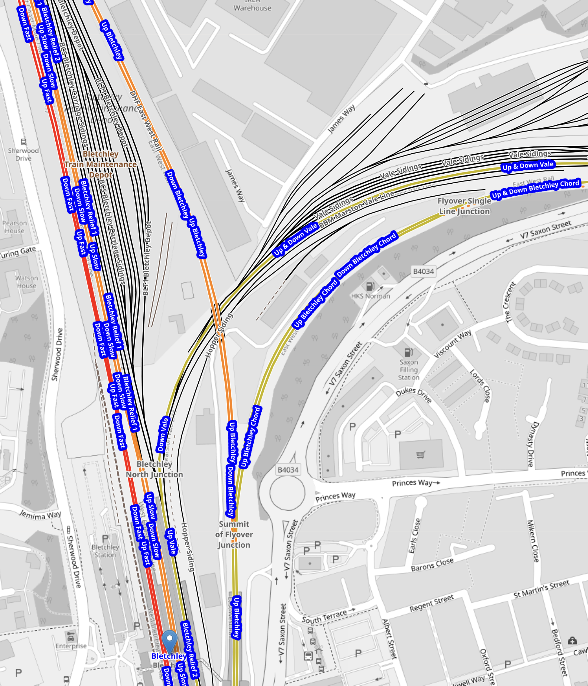
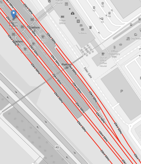
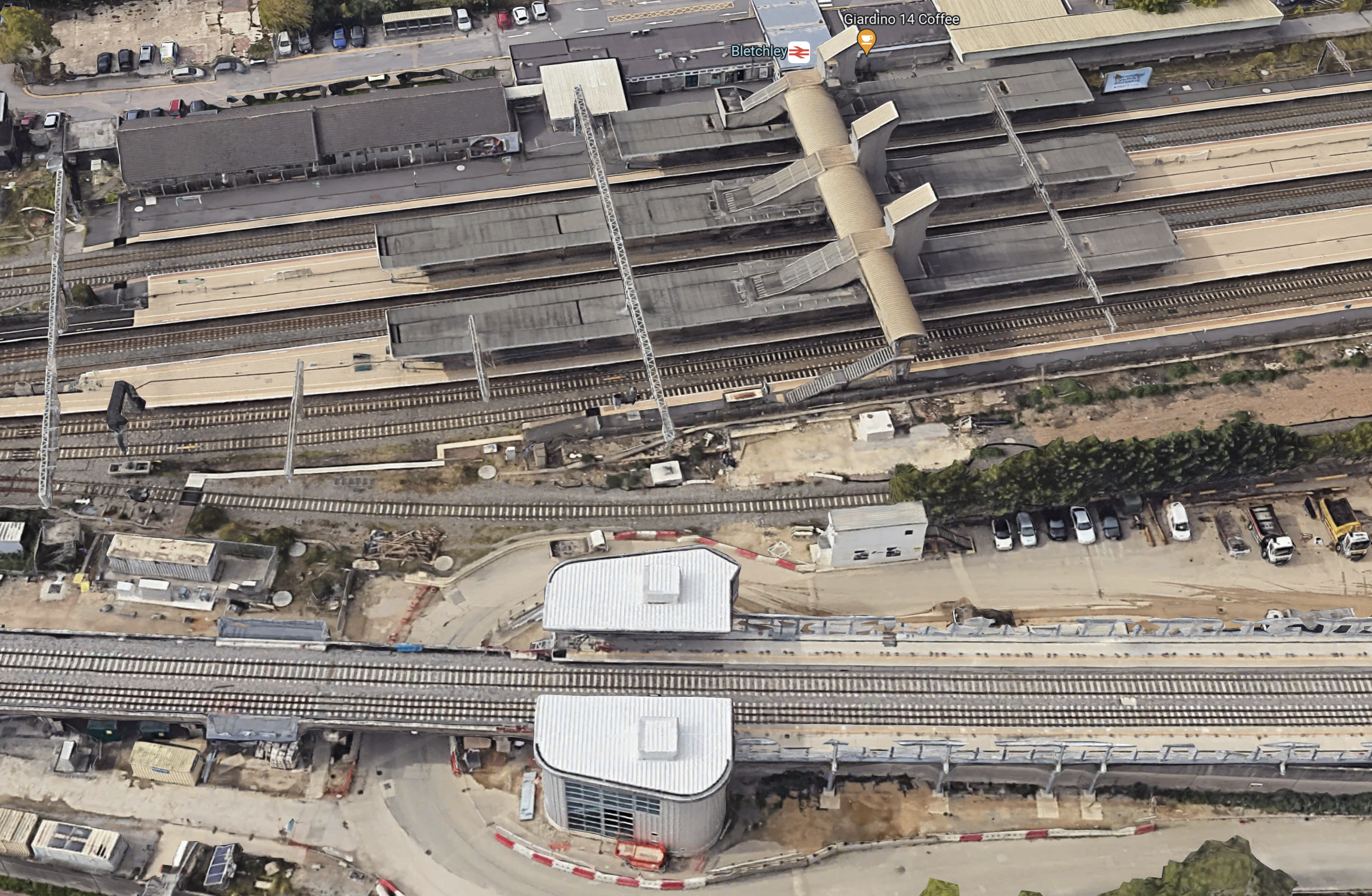
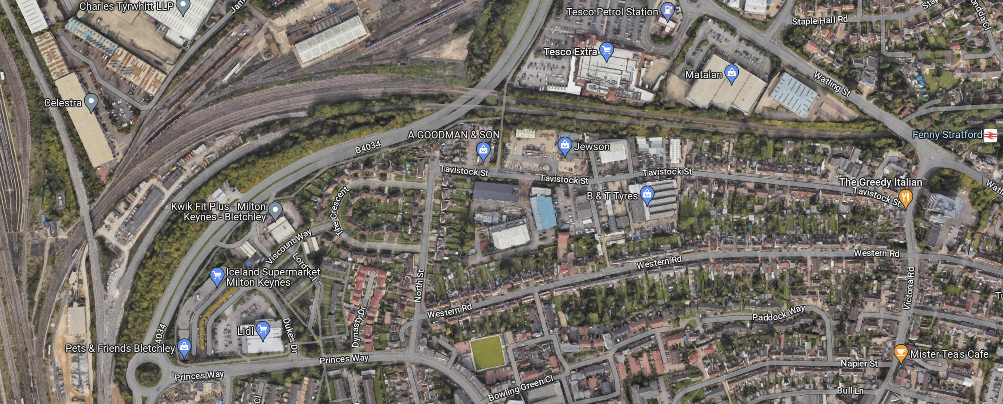
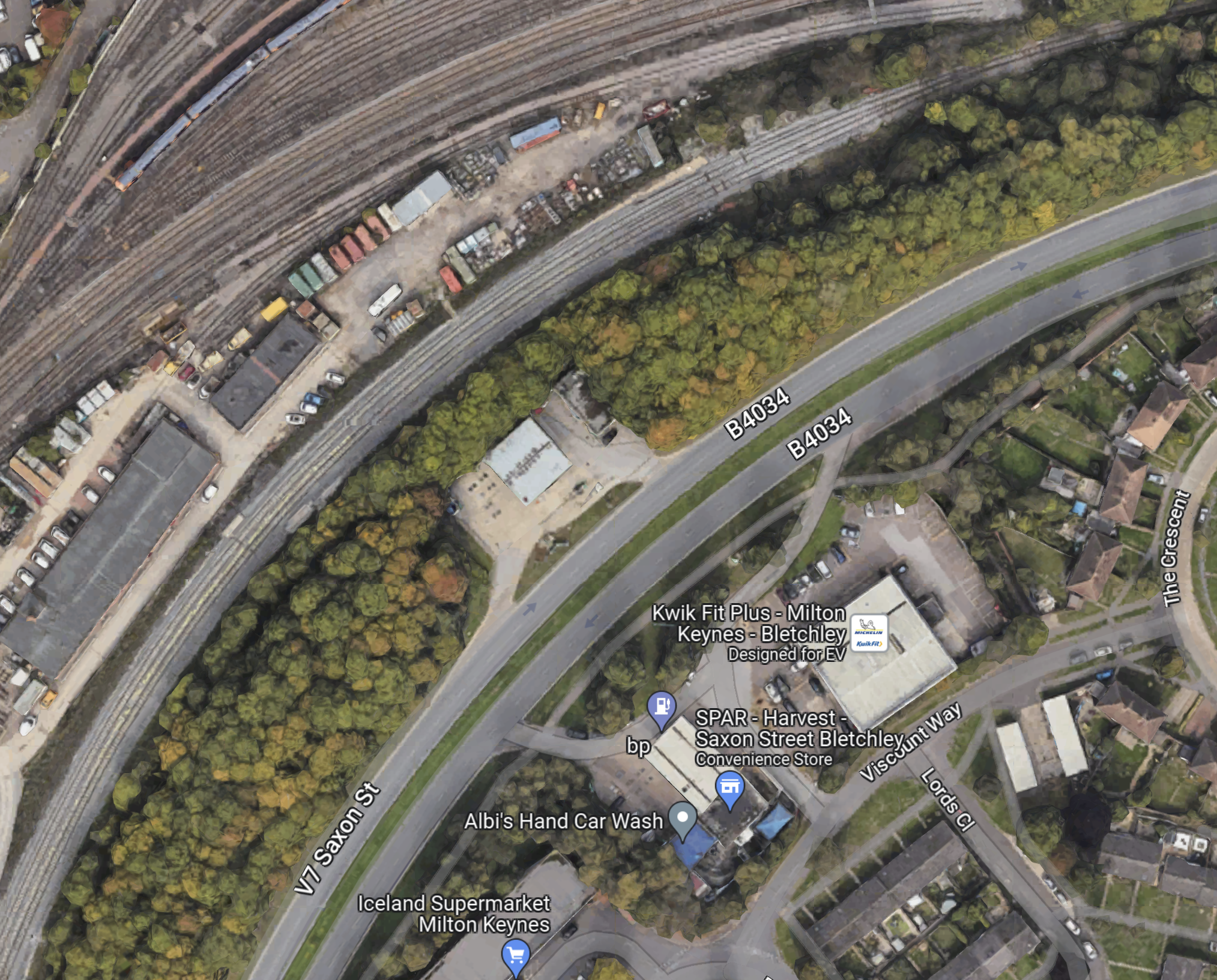
This OpenRailwayMap shows Bletchley station and the flyover on the East side of the station.
Note.
- The West Coast Main Line is on the West side of the map.
- Bletchley station is indicated by the blue arrow at the bottom of the map.
- To the East of the station is Bletchley flyover, which is labelled “Summit of Bletchley Flyover.
- The flyover splits with one branch going North to Milton Keynes and the other East to Bedford.
It does appear, that no train can go between Milton Keynes Central and Bedford stations, without a reverse at Bletchley station.
But you can go between Milton Keynes Central and Oxford stations, without a reverse at Bletchley station, as you stop on the flyover.
To check, I read the tracks right, I asked Google AI, “Can Trains Go Between Bedford And Milton Keynes Central Without A Reverse At Bletchley and received this answer.
Currently, no. Trains running between Bedford and Milton Keynes Central cannot bypass a reversal (reversing direction) at Bletchley because the Marston Vale line terminates at Bletchley station. Trains must enter Bletchley and then change direction to join the West Coast Main Line to reach Milton Keynes Central.
Key Details:
Current Routing: The Marston Vale line connects Bedford and Bletchley. Services from Bletchley to Milton Keynes Central operate as a separate connection.
The Reversal: Passengers currently must change trains or experience a driver change/reversal at Bletchley to continue.
Future Changes: The East West Rail project aims to improve these connections, but as of early 2026, the direct link remains through Bletchley.
Conclusion
Does this explain, why there is a Rail Replacement Bus rather than a shuttle train between Bedford And Milton Keynes Central stations?
East West Rail Unveils Next Phase For Oxford-Cambridge Growth
The title of this post, is the same as that of this press release from the UK Government.
These three bullet points act as sub-headings.
- more frequent trains on the horizon for millions of passengers between Oxford and Cambridge as multibillion pound East West Rail project confirms next steps
- new rail station set to help serve upcoming Universal theme park in Bedford, as well as improvements planned for several existing stations
- new route delivers on the government’s Plan for Change, unlocking £6.7 billion of regional economic growth and delivering up to 100,000 new homes
These two introductory paragraphs make a few general points about the overall project, housing and jobs.
Millions of people across the Oxford to Cambridge corridor are set to benefit from more frequent trains as the East West Railway Company (EWR Co) has revealed the next steps for the second phase of the project today (19 November 2025).
As one of Britain’s largest transport projects, East West Rail forms a cornerstone of the government’s Plan for Change, unlocking £6.7 billion of regional economic growth by 2050, enabling up to 100,000 new homes and supporting tens of thousands of new jobs along the route.
These sections make some more detailed points.
How Many Permanent Staff Will Be Employed At Universal Studios Bedford?
As many will want to live locally, this will surely encourage many to use the trains on the East-West Rail to travel to work, so this will be an important factor.
I asked Google AI, the question in the title of this section and received this answer.
Universal Studios plans to employ 8,000 permanent staff at its new resort in Bedford. This number is part of an overall total of approximately 28,000 jobs, which includes 20,000 jobs during the construction phase.
My project management knowledge is telling me that the station should be built before the theme park.
How Many Daily Visitors Are Expected At Universal Studios Bedford?
I asked Google AI, the question in the title of this section and received this answer.
The Universal Studios theme park in Bedford is expected to have 55,000 visitors on peak days from its launch, based on its plan to handle 8.5 million annual visitors. The project, planned to open in 2031, is expected to attract 8.5 million annual visitors in its first year, with numbers rising to 12 million within 20 years.
I would expect a large number of visitors and staff will probably be encouraged to come by train, just as they are at some Premier League football stadiums.
Will Universal Studios Bedford Be Marketed As A Low Carbon Theme Park?
I’m asking this question, as it seems, the railway is being upgraded make this easier.
I asked Google AI, the question in the title of this section and received this answer.
Yes, it appears Universal Studios Bedford will be marketed as having a low-carbon focus, as evidenced by its planning applications that highlight sustainability efforts. The project outlines include goals for water conservation, energy reduction and clean energy use, waste minimization, and the use of low-carbon materials, all of which will likely be part of the marketing narrative for the theme park, according to LinkedIn.
How Many Car Parking Spaces Will Be Provided At Universal Studios Bedford?
I asked Google AI, the question in the title of this section and received this answer.
The Universal Studios resort planned for Bedford will include a minimum of 7,106 parking spaces and 100 coach bays. The resort is also expected to have 250 cycle spaces and enough room for over 7,100 cars
That is a lot of car parking spaces. Hopefully, there will be a lot of car charging points.
Increased Train Frequency And Capacity
These two paragraphs from the press release, talk about increased train frequency and capacity.
Following extensive consultation with local communities, the multi-billion-pound project has confirmed it is exploring a series of transformative plans including increasing the proposed frequency of trains from 3 or 4 to up to 5 per hour.
These enhancements could provide up to 70% more seating across the route, easing overcrowding and speeding up boarding, as well as cutting average waiting times, improving service resilience and creating a smoother, more reliable passenger experience.
When you consider that London Overground, Merseytravel, the South Wales Metro, West Midlands Trains and other local lines in the UK consider than four trains per hour to be a minimum service, then five trains per hour is to be welcomed.
Station Improvements And New Stations
These two paragraphs from the press release, talk about station improvements and new stations..
Several other improvements across the route have also been confirmed, including new station entrances at Bletchley, Cambridge and Bedford, as well as four brand-new stations along the Marston Vale Line – the first significant investment since the 1960s.
With the current stations on the Marston Vale Line seeing some of the lowest usage in the country, the new stations will better serve local communities by providing faster, more frequent services, as well as helping to serve the upcoming Universal theme park.
I thought Bletchley, Cambridge and Bedford stations had already been substantially improved in recent years.
A New Station At Stewartby
Are the station improvements to upgrade public transport access to the Universal theme park at Stewartby station?
- An East-West Rail service between Oxford and Stansted Airport via Bletchley, Milton Keynes Central, Stewartby, Bedford and Cambridge would give the Universal theme park all-important airport access.
- Would an upgraded Bletchley station improve interchange between the West Coast Main Line and East-West Rail give better access to the theme park from London, the West Midlands and North-West for visitors?
- Would an upgraded Bedford station improve interchange between the Midland Main Line and East-West Rail give better access to the theme park from London, the East Midlands and North-East for visitors?
- An upgraded Bedford station could also be marketed as a zero-carbon route between the theme park and the Continent via St. Pancras International and Eurostar.
- Would an upgraded Cambridge station give better access to the theme park from the East of England?
In addition four new stations on the Marston Vale Line would improve access for visitors and staff, who live locally.
Will Battery-Electric Trains Be Used On The East-West Rail?
As five major East-West Rail stations; Bedford, Bletchley, Cambridge, Milton Keynes and Reading are substantially served by main line electric trains, and it is likely that more stations will be in future, I believe that East-West Rail must either be electrified or services should be run by battery-electric trains, which would enable zero-carbon rail routes to and from London and all the city’s airports, Birmingham, Liverpool, Manchester and an increasing number of cities in the North and Midlands of England, and Scotland and Wales.
I asked Google AI, the question in the title of this section and received this answer.
Yes, the East West Rail (EWR) project plans to use battery-electric trains as part of a discontinuous electrification strategy. This means trains will run on overhead electric power in sections where they are installed, and on onboard batteries in other sections of the route.
It does appear that discontinuous electrification and battery-electric trains will be used.
Electrification At Bedford Station
This OpenRailwayMap shows The East side of Bedford station.
Note.
- The red tracks are electrified and black tracks are not.
- The black track looping into the station from the East is the Marston Vale Line, which will connect the East-West Rail to Bedford station.
- At the Easternmost part of the curve is Bedford St. Johns station, which serves Bedford hospital.
- The Marston Vale Line services normally connect to Platform 1A at Bedford station.
- But it also appears trains can also use Platforms 1 and 2 at Bedford station.
- It also appears that that Platforms 1A, 1 and 2 are all electrified.
This picture confirms electrification in Platforms 1A and 1.
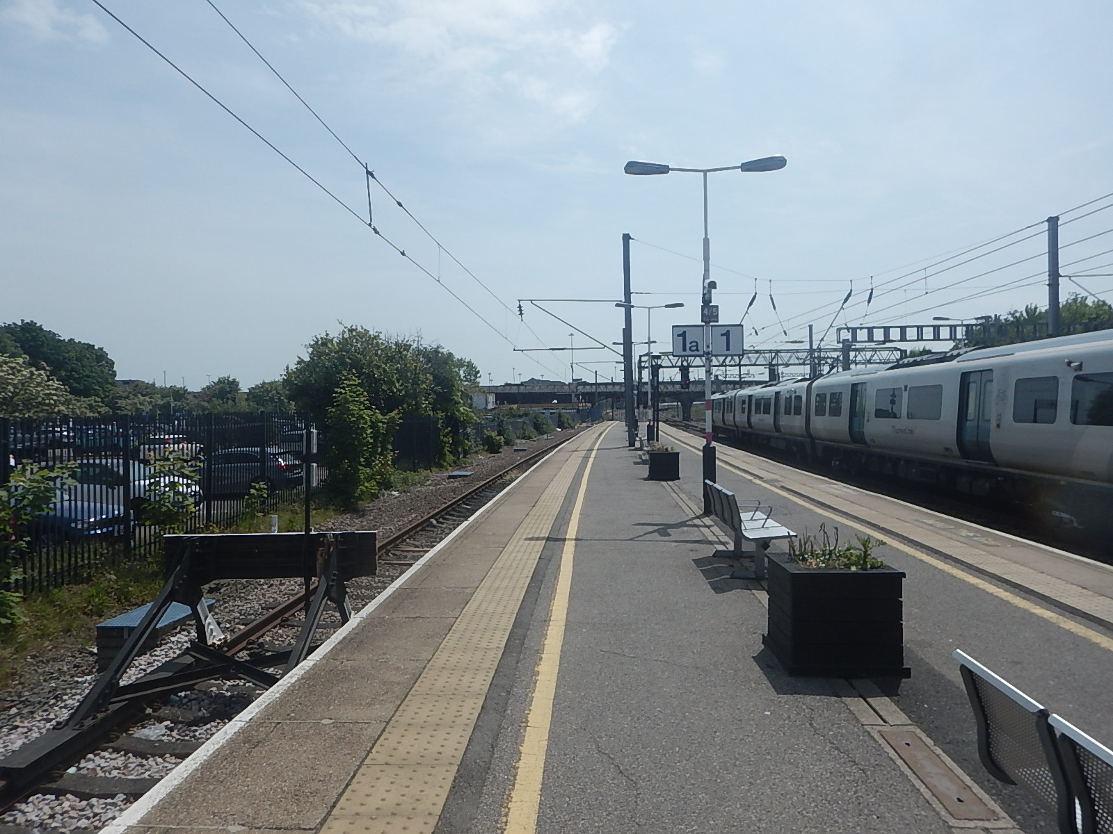
Note.
- Platform 1A is on the left.
- Platform 1 is on the right.
- The Thameslink train on the right is in Platform 2.
- Platforms 1A, 1 and 2 are all clearly electrified.
- Platform 1A is 81 metres long, so could accept a typical four-coach train.
Battery-electric trains with pantographs could certainly by charged in either of these two platforms at Bedford station.
Electrification At Milton Keynes Central Station
It would appear that East-West Rail services will use Platform 2A at Milton Keynes Central station.
This OpenRailwayMap shows Platform 2A at Milton Keynes Central station.
Note.
- The red tracks are electrified and black tracks are not.
- Platform 1 is the through platform on the North-East side of the station.
- Platform 2A is the bay platform tucked underneath Platform 1.
- Platform 2A is clearly electrified.
- Platform 2A is 124 metres long, so could accept a typical five or six-coach train.
These pictures show Platforms 1 and 2A at Milton Keynes Central station.

Battery-electric trains with pantographs could certainly by charged in Platform 2A at Milton Keynes Central station.
Electrification At Oxford Station
It would appear that terminating East-West Rail services will use Platform 1 or 2 at Oxford station.
This OpenRailwayMap shows the platforms at Oxford station.
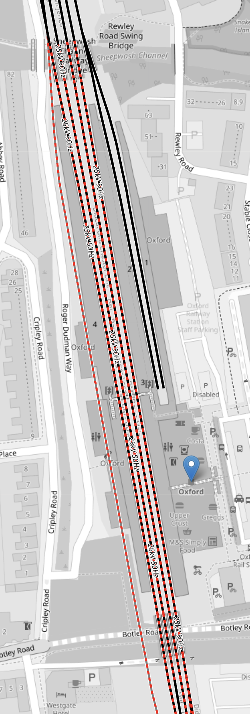
Note.
- The red and black tracks are to be electrified and black tracks are not.
- Platforms 1 and 2 are shown in black and are likely to be used by terminating East-West Rail trains.
- Platforms 1 and 2 would need to be electrified to be able to charge trains.
- Platforms 1 and 2 would also be used by Chiltern’s London services.
- Platform 1 and 2 are respectively 157 and 160 metres long, so could accept a typical five or six-coach train.
- As Oxford and Reading is to be electrified, through East-West Rail trains could use that electrification to travel to and from Reading.
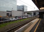
These pictures show Platforms 1 and 2 at Oxford station.
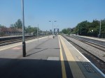
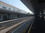

Battery-electric trains with pantographs could certainly by charged in Platform 1 and 2 at Oxford station, if the platforms were electrified.
Electrification At Reading Station
The West-facing platforms at Reading station are all electrified and longer than 120 metres, so could accept a typical four or five-coach train.
What Trains Should Be Used?
Consider.
- There is only one battery-electric train, that has been tested on the UK rail network – The Hitachi Class 802 train or similar.
- There is only one battery-electric train, that has been ordered – The Hitachi Class 802 train or similar.
- The longest distance on battery, between Reading and Bedford, is probably about thirty miles.
The Government could do a lot worse than order some more Class 802 trains, that were tailored for East-West Rail.
The Hitachi Class 802 train has five-cars, which are 26 metres long.
- It has a 125 mph operating speed.
- It has a range of 45 miles on battery power.
- The trains have been proven in service.
- The trains are made in the UK.
- The trains could handle extended routes like Birmingham and Stansted Airport or Cardiff and Cambridge.
A four-car variant of the train with a 100 mph operating speed could be an alternative.
What Will Be The Initial East-West Rail Service?
I asked Google AI, the question in the title of this section and received this answer.
The initial East West Rail service will be between Oxford and Milton Keynes/Bletchley, with passenger services delayed until at least 2026 due to a dispute over train crew roles. Freight services began in June 2025, and temporary diesel services will run until the line is electrified. The full project aims to connect Oxford and Cambridge.
Note.
- Stewartby station for Universal Studios Bedford will not be served by East-West Rail initially.
- But I suspect, that the current Marston Vale Line service will continue, with a change if needed at Bletchley or Bedford to get to Stewartby.
- Earlier I showed that Google AI is predicting 20,000 construction jobs at Universal Studios Bedford, which I am sure will need some form of high-capacity rail transport, if grid-lock is to be avoided in much of Bedfordshire.
Perhaps an initial fleet of four- or five-car Class 802 diesel-electric trains could be ordered and they would run the full route between Oxford and Bedford stations, with a reverse in Platform 2A at Milton Keynes station.
- The trains would run initially on diesel.
- By using stepping-up in Platform 2A at Milton Keynes station, I believe a two trains per hour (tph) service could surely be run.
- Hitachi could probably deliver the trains quickly, as they have not long been out of production.
- Those living locally would get a much improved train service from their local station to and from Bedford, Milton Keynes or Oxford.
- A large portion of the onward connectivity of the East-West Rail would be delivered early to the benefit of locals and visitors.
- If extra services are needed, semi-fast services could be added between Bedford and Reading with stops at Stewartby, Bletchley, Bicester Village, Oxford Parkway and Oxford stations.
When Platforms 1 and 2 at Oxford station are electrified and the trains are converted to battery-electric operation, the route could be converted to zero-carbon operation.
Virtually Nothing Is Said About The Route Of The East-West Rail Between Bedford and Cambridge South Stations Via Tempsford Station
This quote from David Hughes, CEO, East West Railway Company, is the only time, that Tempsford is mentioned in the press release.
“From a new station at Cambridge East to better access in Oxford and clear alignment through Tempsford, East West Rail is shaping the modern, sustainable transport link this region needs to thrive.”
I asked Google AI, if the proposed route of the East-West Rail between Bedford and Cambridge South stations through Tempsford is controversial and I received this reply.
Yes, the proposed route of East West Rail between Bedford and Cambridge is controversial, with opposition from some local residents and political figures who have expressed concerns about the southern alignment through Tempsford and surrounding villages. However, East West Rail Co has selected the route north of the Black Cat roundabout as the preferred alignment, citing reasons like cost-effectiveness and fewer disruptions, while also updating designs to include a southern station entrance to connect with planned growth areas around Tempsford.
Does Government or Artificial Intelligence have precedence?
Cambridge East Station Gets A First Mention
This quote from David Hughes, CEO, East West Railway Company, is the first time, that I’ve seen Cambridge East station mentioned.
“From a new station at Cambridge East to better access in Oxford and clear alignment through Tempsford, East West Rail is shaping the modern, sustainable transport link this region needs to thrive.”
In this document on the East-West Rail Consortium web site, there is extensive talk of an A14 Parkway station.
- The document dates from 2018.
- Google AI can’t find any trace of the A14 Parkway station referred to in the document.
- This article on the BBC, which was written five days ago and is entitled Additional City station Proposed By East West Rail, is the only reference on the Internet, that references Cambridge East station.
- The BBC article also says that other proposals after consultation include a new eastern entrance for Cambridge station, locating Cambourne station closer to the town and a mined tunnel for Bourn Airfield.
- I also have to assume that A14 Parkway has also morphed into Cambridge East station.
- To access all my posts, that relate to A14 Parkway, click this link.
But it does seem that consultation appears to have produced an acceptable compromise.
Between Kempston Hardwick and Tempsford Stations Through Bedford
I’ve now found that OpenRailwayMap has been updated between Bedford and Cambridge.
This first section shows the route between Kempston Hardwick and Tempsford stations through Bedford.
Note.
- Kempston Hardwick station is in the South-West corner of the map.
- The yellow track is the Marston Vale Line, which goes through Bedford St. Johns and Bedford stations.
- The red track on the West side of the map is the Midland Main Line.
- The red track on the East side of the map is the East Coast Main Line.
- The dotted red line across the top of the map will be the route of the East-West Rail.
- Tempsford station will be to the South-West of where the East Coast Main Line and East-West Rail cross in the North-East cornet of the map.
I hope the good people of Bedford are happier now!
Between Tempsford and Cambourne
I’ve now found that OpenRailwayMap has been updated between Bedford and Cambridge.
This second section shows the route between Tempsford and Cambourne stations.
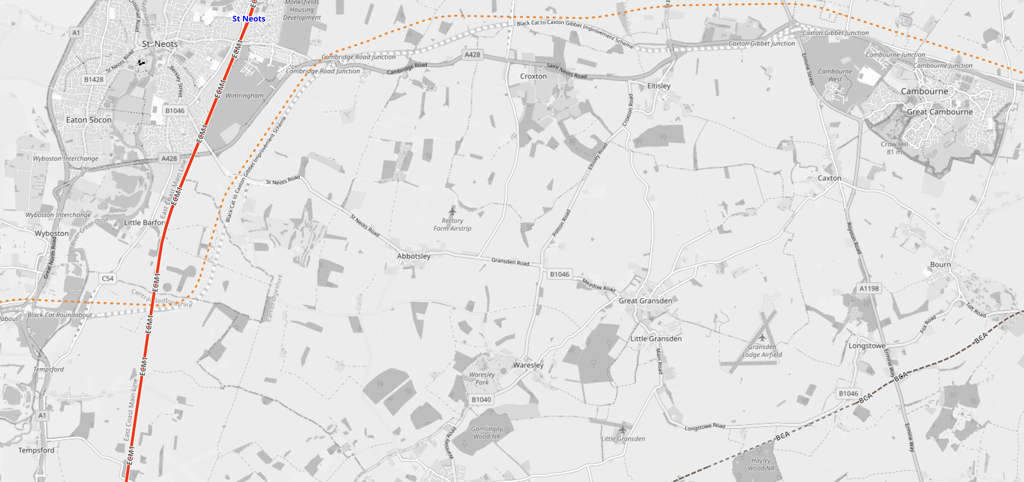
Note.
- The dotted red line across the top of the map will be the route of the East-West Rail.
- Tempsford station is in the South-West corner of the map on the route of the East-West Rail.
- The red track on the West side of the map is the East Coast Main Line.
- Cambourne is the village in the North-East corner of the map.
Council Opposes Six Track Plan For East West Rail
The title of this post, is the same as that of this article on the BBC.
This is the sub-heading.
Councillors have voted to oppose part of a major railway line being built through their district.
These four paragraphs add detail to the story
Bedford Borough Council wants the East West Rail (EWR) line to be made up of four tracks, rather than six, in the Poets area north of the town.
Thirty-seven homes would need to be demolished in order to accommodate the two additional tracks.
However, in their full-council meeting on Wednesday, members agreed to support other parts of the project, such as the relocation of Stewartby station and the closure of Kempston Hardwick.
An EWR spokesperson said it was committed to working with local communities.
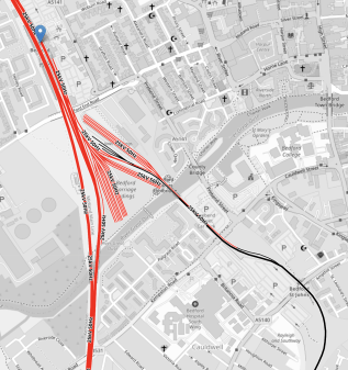
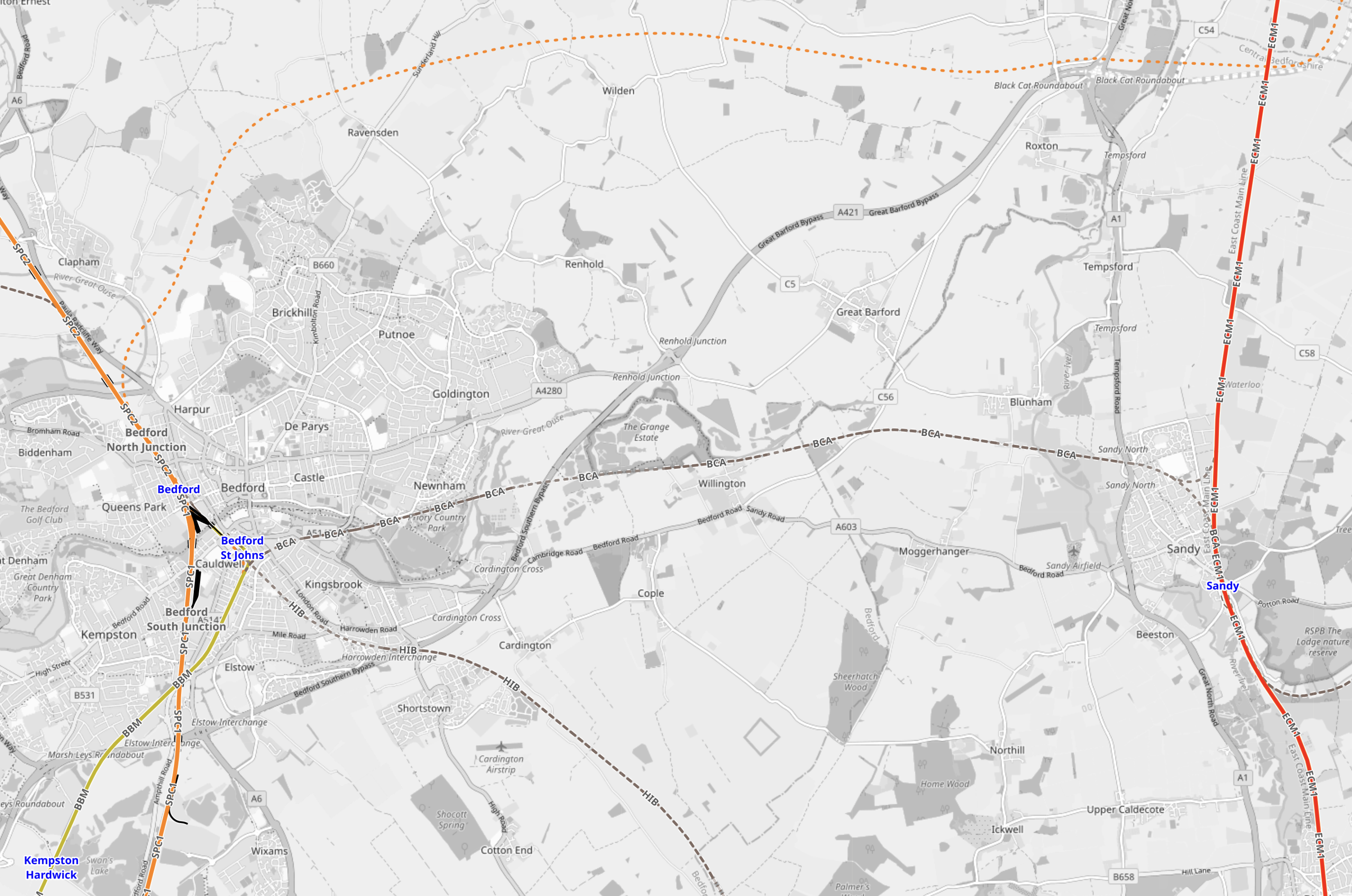
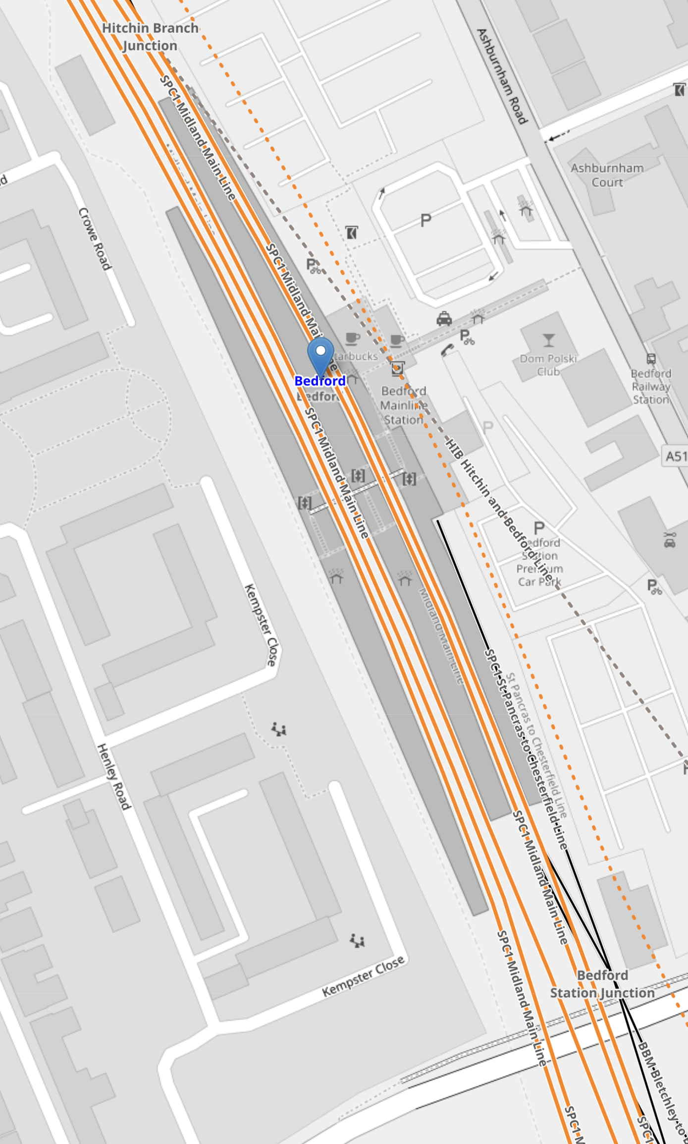
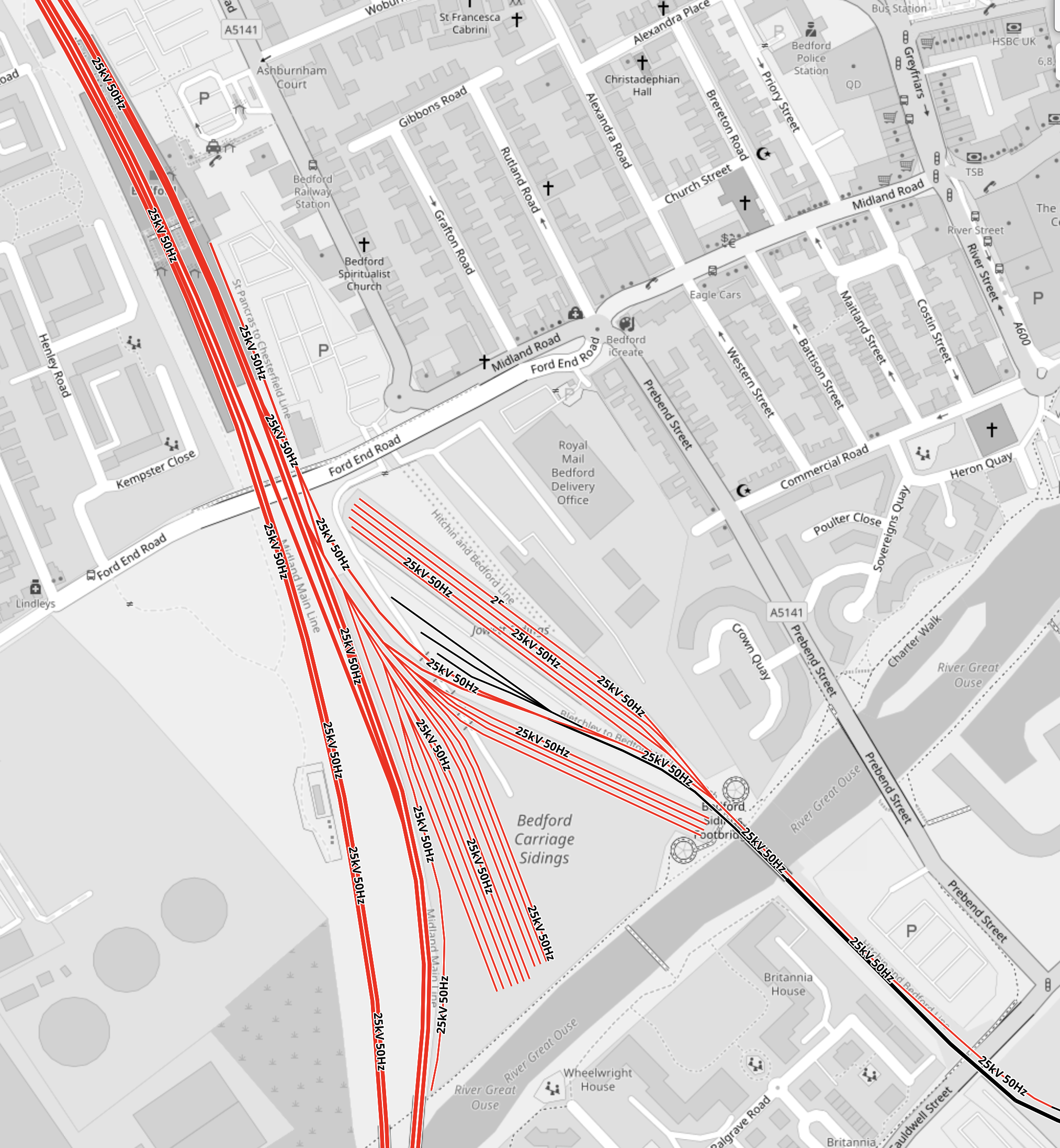
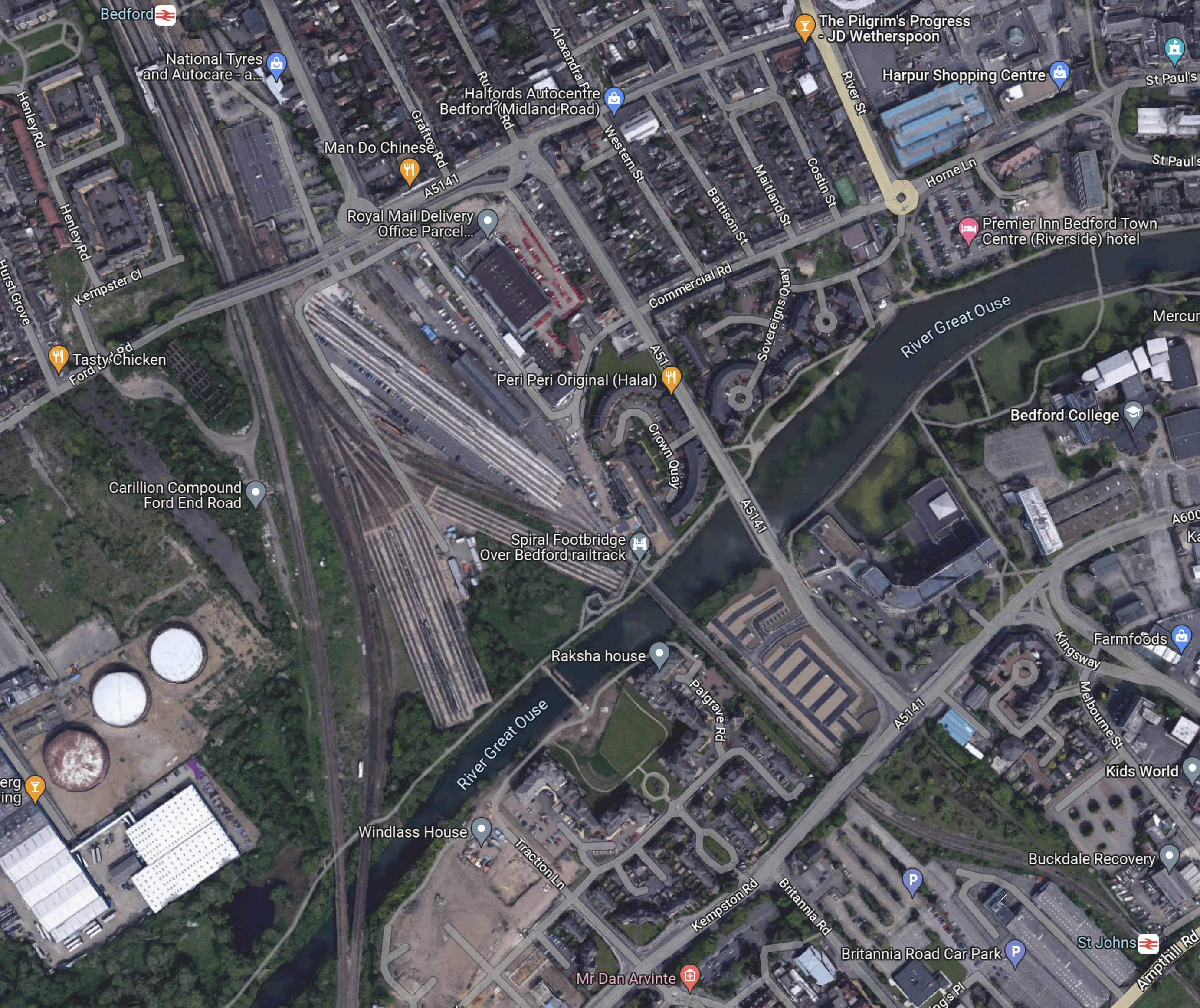
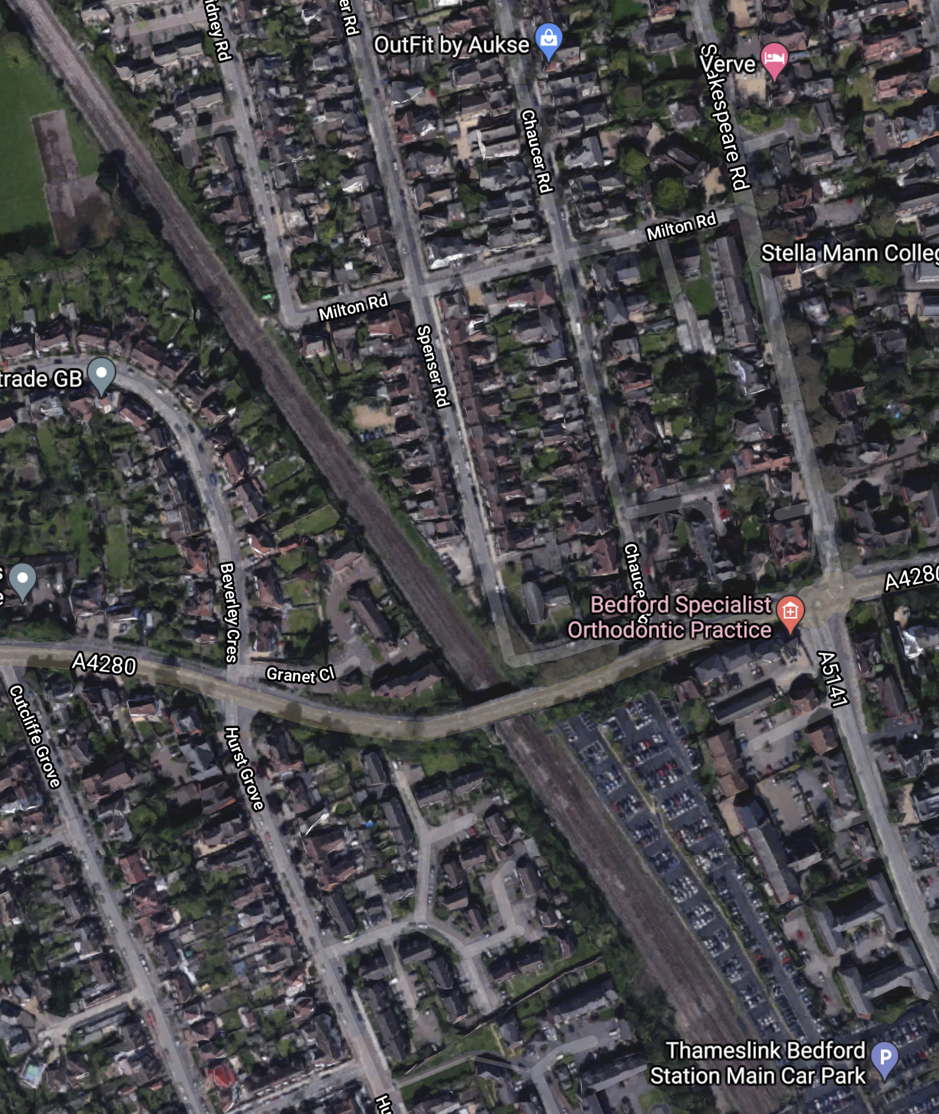
This OpenRailwayMap shows the Midland Main Line and the East-West Rail through Bedford.
Note.
- The solid orange line running from the North-West corner of the map to its Southern edge is the electrified Midland Main Line.
- The blue arrow on this line indicates Bedford station.
- The blue lettering to the South-East of Bedford station, indicates Bedford St. Johns station.
- The yellow line connecting the two stations is the Eastern end of the Marston Vale Line, which connects Bedford and Bletchley stations.
- The Marston Vale Line will be taken over by the East-West Rail.
- Just North of Bedford station is Bedford North junction.
The East-West Rail branches away from Bedford North junction to the North-East on its way to Cambridge. It is shown as a dotted orange line.
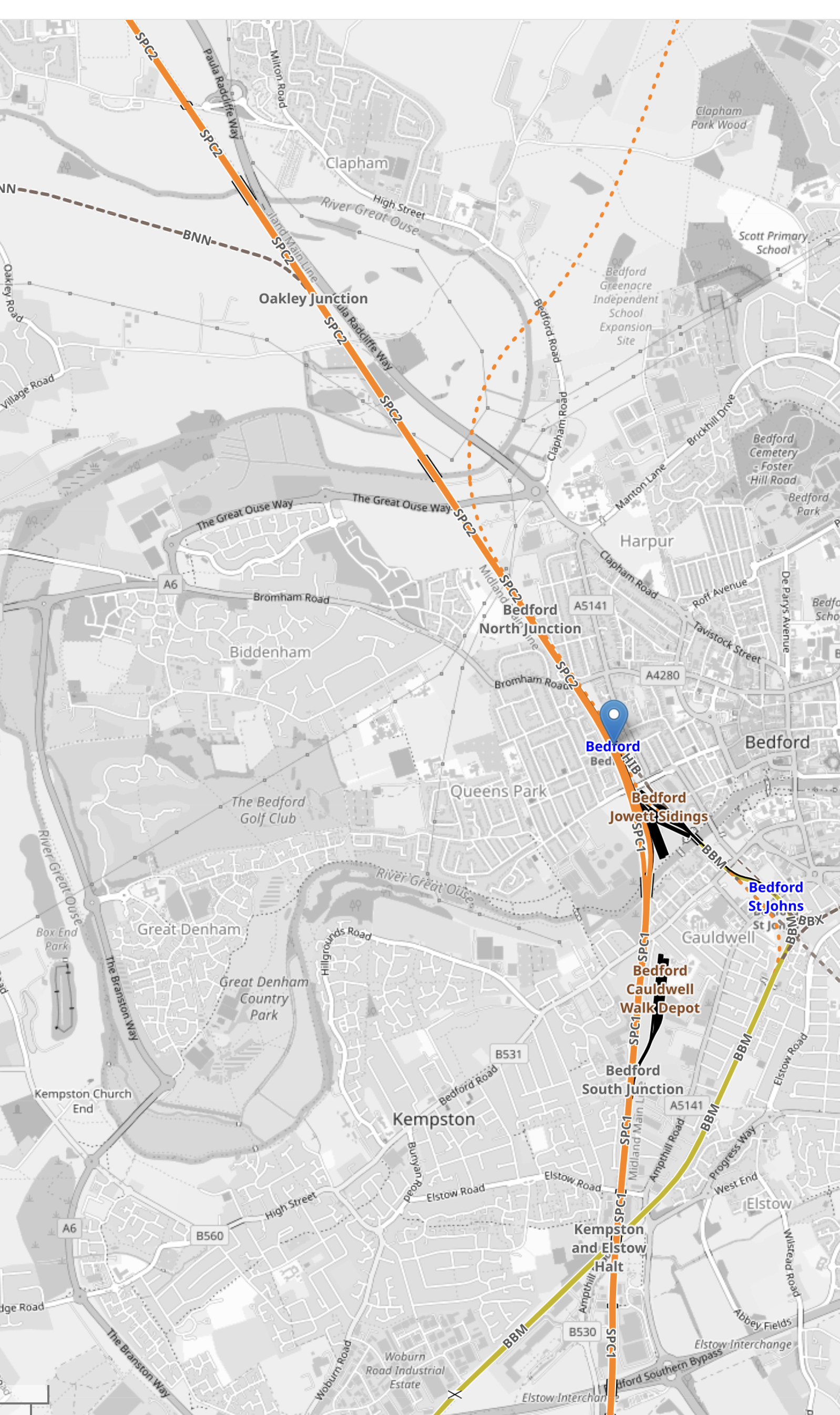
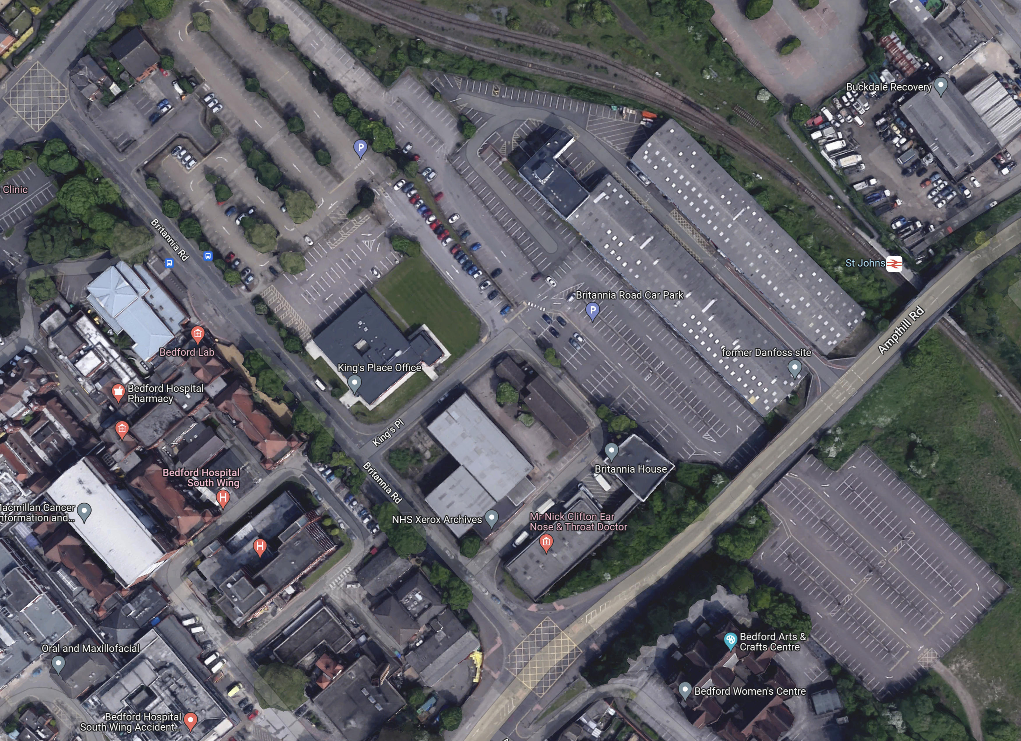
This OpenRailwayMap shows Bedford station to a larger scale.
Note,
- The Western pair of orange lines are the current fast lines of the Midland Main Line.
- The Eastern pair of orange lines are the current slow lines of the Midland Main Line.
- To the East the orange dotted line shows indicates a proposed route of the East-West Rail.
- There appear to be crossovers that allow East-West Rail services to use Platforms 1 and 2 through Bedford station.
Between the Midland Main Line and East-West Rail platforms, the current Platform 1A used by the Marston Vale Line can be seen.
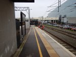
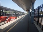
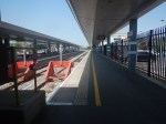
This picture show the current Marston Vale Line platform at Bedford station,
Note.
- The Marston Vale Line platform is on the left.
- It is numbered 1A.
- The platform is electrified, so can it be it used to terminate some Thameslink services.
It could also be used to terminate East-West Rail services from the West and if they were battery-electric trains they could be charged.
Oxford and Bedford is 51 miles or 82 kilometers, which is within range of a modern battery-electric train. Es[ecially, if it did a ‘splash and dash’ at Milton Keynes Central or Bletchley!
This OpenRailwayMap shows the lines to the North of Bedford station.

Note.
- The current four-track Midland Main Line running diagonally across the map.
- The East-West Rail running along on the East side and branching off to Cambridge.
- Crossovers between the Midland Main Line and East-West Rail.
It looks to me, that operation of East-West Rail trains through Bedford station will be as follows.
- Oxford to Cambridge trains will use the crossovers to call in the existing Platform 2 at Bedford station.
- Cambridge to Oxford to will use the crossovers to call in the existing Platform 1 at Bedford station.
- Trains that are not stopping could use the avoiding line along the East side of the station.
- Oxford to Bedford terminating trains, would stop in Platform 1A.
Because there would be a crossover between the Midland Main Line slow lines and the East-West Rail to the South and North of Bedford station, I suspect for operatuional reasons and safety Network Rail want a double track avoiding line.
‘Rollercoasters In My Back Yard’: Welcome To Universal Studios Bedford
The title of this post, is the same as that of this article on The Times.
This is the sub-heading.
Britain’s answer to Orlando could be a 480-acre world boasting big rides, bigger films and 7m visitors a year. Some locals are far from enchanted
These three paragraphs introduce the story.
Picture the scene: It’s a snowy Christmas Eve, 2030, at King’s Cross station. Dozens of families from across the UK and Europe gather as the station speakers announce: “The train now leaving platform 9¾ is the Hogwarts Express, calling at the Wizarding World of Harry Potter. And Bedford.”
The stuff of JK Rowling’s fiction? Perhaps not.
For, if all goes to plan, a featureless 480 acres of industrial and agricultural land a short broomstick’s ride from downtown Bedford will, by the end of the decade, become one of the world’s most spectacular theme parks.
I have a few thoughts.
Eden Project Morecambe
Eden Project Morecambe will be the first of a new generation of theme parks in the UK.
The new Eden Project is to be developed at Morecambe, which is close to Lancaster. As Lancaster will be an High Speed Two terminus, Eden Project North could be connected to HS2 by a high tech shuttle like the Luton DART. So the Eden Project North will also attract day trippers from a large proportion of England and the South of Scotland.
I believe increasingly we will see theme parks, bringing in their visitors on futuristic public transport systems.
The Location Of Universal Studios Bedford
This map from Universal Destinations & Experiences shows the location of the site of the proposed Universal Studios Bedford.
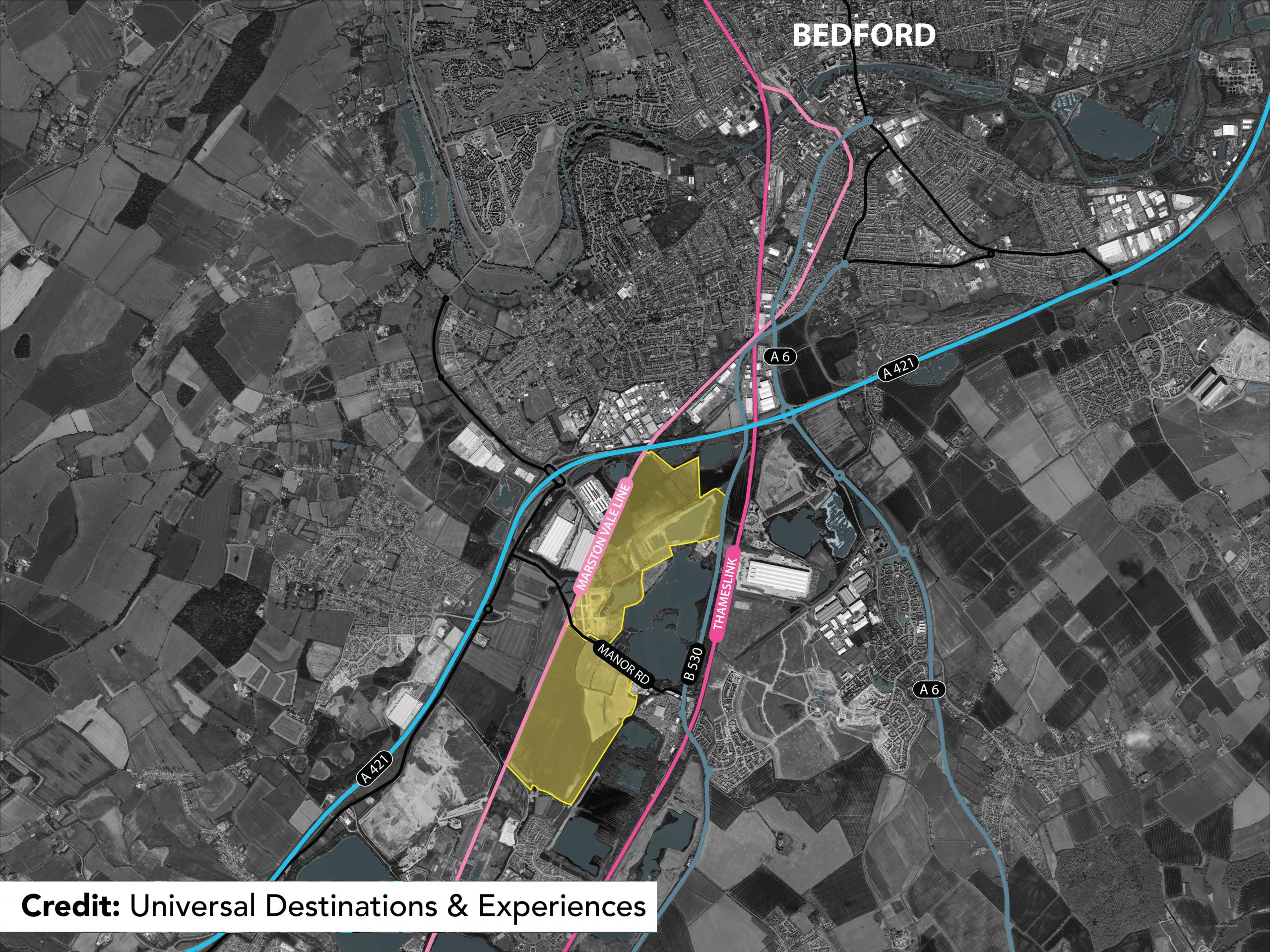
Note.
- The site is shown by yellow shading.
- The blue lines are major roads.
- The pink lines are railways.
- The rail link running to the West of the site is currently the Marston Vale Line, which is being developed into the East West Railway between Oxford and Cambridge via Milton Keynes.
- The East West Railway will also connect to Ipswich, Norwich and Reading.
- The rail link running to the East of the site is the Midland Main Line, which links St. Pancras station with Derby, Nottingham and Sheffield.
The site certainly has excellent transport connections.
Expanding Rail Connections At Universal Studios Bedford
I believe that in these days of climate change, that theme parks and other attractions like sports stadia and shopping centres will develop their rail connections.
Universal Studios Bedford could have two stations.
- Kempston Hardwick on the East West Railway.
- Their own station on the Midland Main Line.
Note.
- Both stations could be connected by a futuristic people mover transporting visitors around the site.
- Using current train times, trains would take thirty minutes between the theme park and St. Pancras for Eurostar to and from Europe.
- Thameslink’s trains could shuttle visitors to and from Luton Airport.
It should also be noted that several of Southern England’s most visited sites are just a train ride away.
Easy Places To Visit
These attractions would be easy to visit.
- Bicester Village – Direct train from Kempston Hardwick after 2024.
- Cambridge – Direct train from Kempston Hardwick after 2030.
- London – Direct train from the new station after it’s built.
- Oxford – Direct train from Kempston Hardwick after 2024.
- Woburn Safari Park – Direct train from Kempston Hardwick after 2024.
Note.
All trains would be electric or battery-electric powered.
I have assumed that rail services between Oxford and Bedford open in 2024.
I have assumed that rail services between Oxford and Cambridge open in 2030.
Conclusion
This is an interesting idea, which is at an excellent location. But will the locals like it?
East-West Rail: Electrification
The first paragraph of the Wikipedia entry for the East West Railway, says this about electrification.
As of March 2020, electrification of the line is not planned, but the 2019 decision (to rule it out) is under review.
But I don’t think it’s a simple decision of electrify or not!
These observations are guiding my thoughts.
Milton Keynes Central Station
This OpenRailwayMap shows the platforms and whether they are electrified in Milton Keynes Central station.
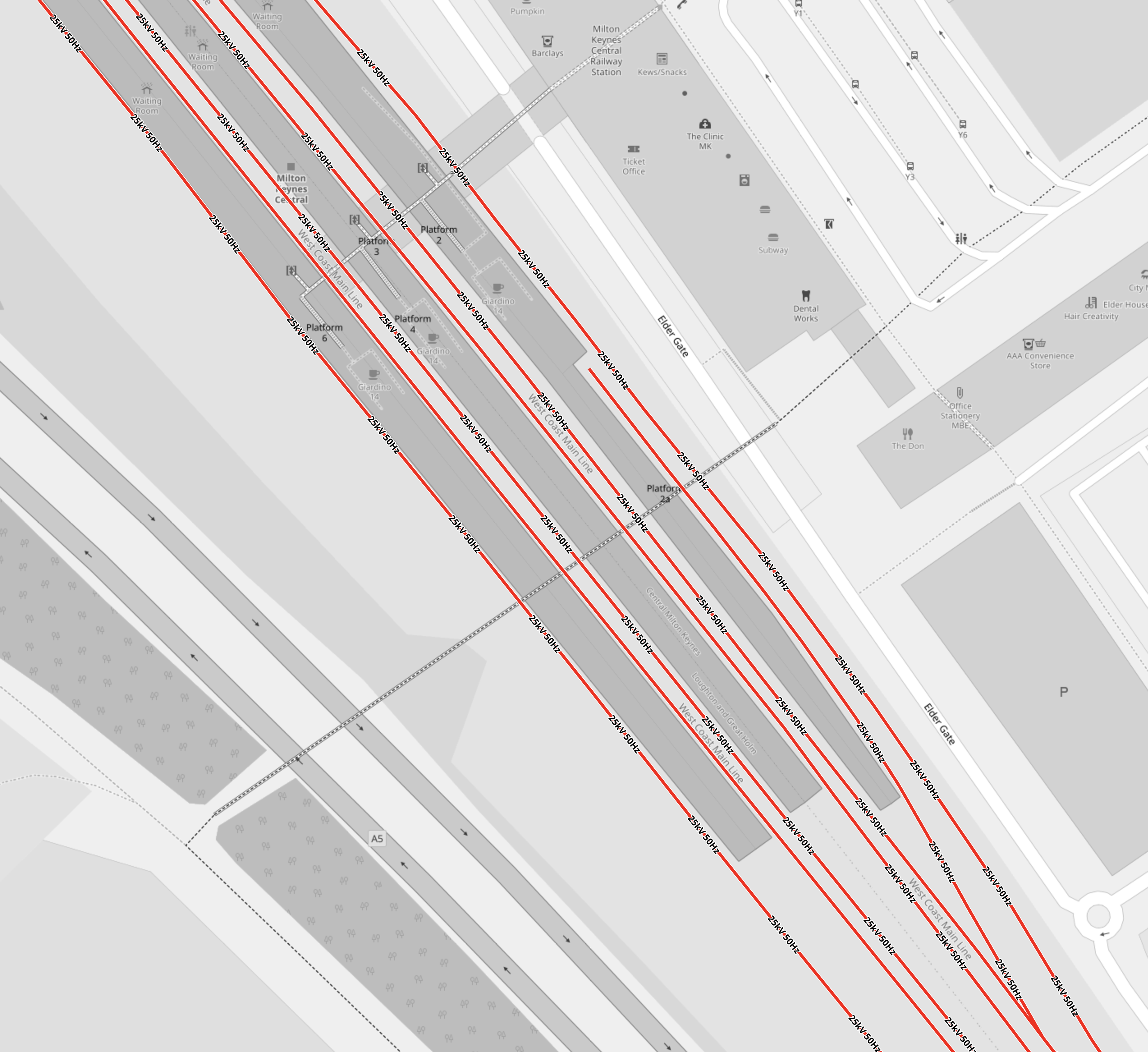
Note.
- Lines shown in red are electrified with 25 KVAC overhead wires.
- The short platform is Platform 2A, which can take a five-car train and was built recently to terminate the Marston Vale Line service.
- Could Platform 2A be ideal for handling and charging, battery-electric trains, that terminate in Milton Keynes station?
The Wikipedia entry for Milton KeynesCentral station, has a section called Platforms and Layout, which gives full details.
Bletchley Station
This OpenRailwayMap shows the platforms and whether they are electrified in Bletchley station.
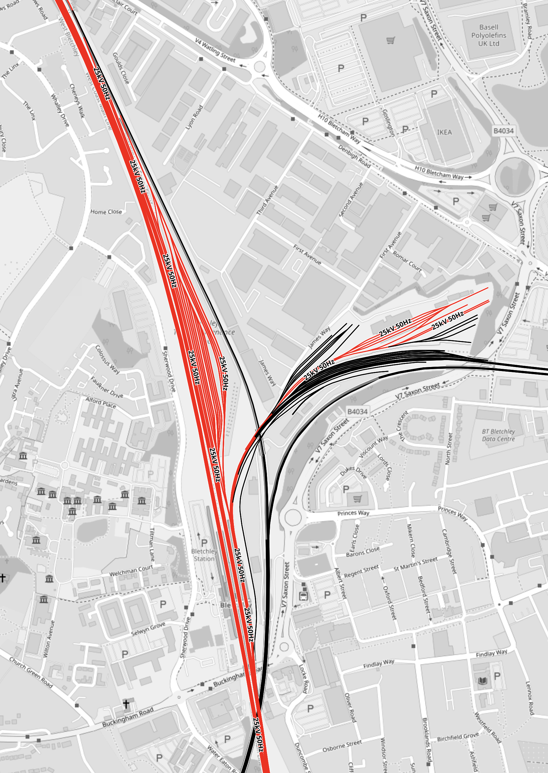
Note.
- Lines shown in red are electrified with 25 KVAC overhead wires.
- The wide swath of red going North is the West Coast Main Line.
- The smaller patch of red to the East of the West Coast Main Line are electrified sidings.
- All low-level platforms at Bletchley station are electrified.
- The viaduct platforms, are shown in black as they are not electrified.
- A non-electrified line leads North-West from the viaduct towards Milton Keynes Central.
- The Milton Keynes end of the line between Milton Keynes Central station and the viaduct is electrified.
- A non-electrified line leads North-East from the viaduct towards Fenny Stratford and Bedford.
The Google Map shows a 3D visualisation of Bletchley station.
I can’t see much sign of any electrification.
Bedford Station
This OpenRailwayMap shows the platforms and the electrification around Bedford station.
Note.
- All platforms at Bedford station are electrified.
- The lines to the West of the station are the electrified Midland Main Line.
- The Marston Vale Line services terminate in the short Platform 1A, which is the South-East corner of the station.
- The track into Platform 1A is electrified for about two hundred metres, through the sidings South of the station.
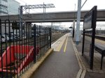
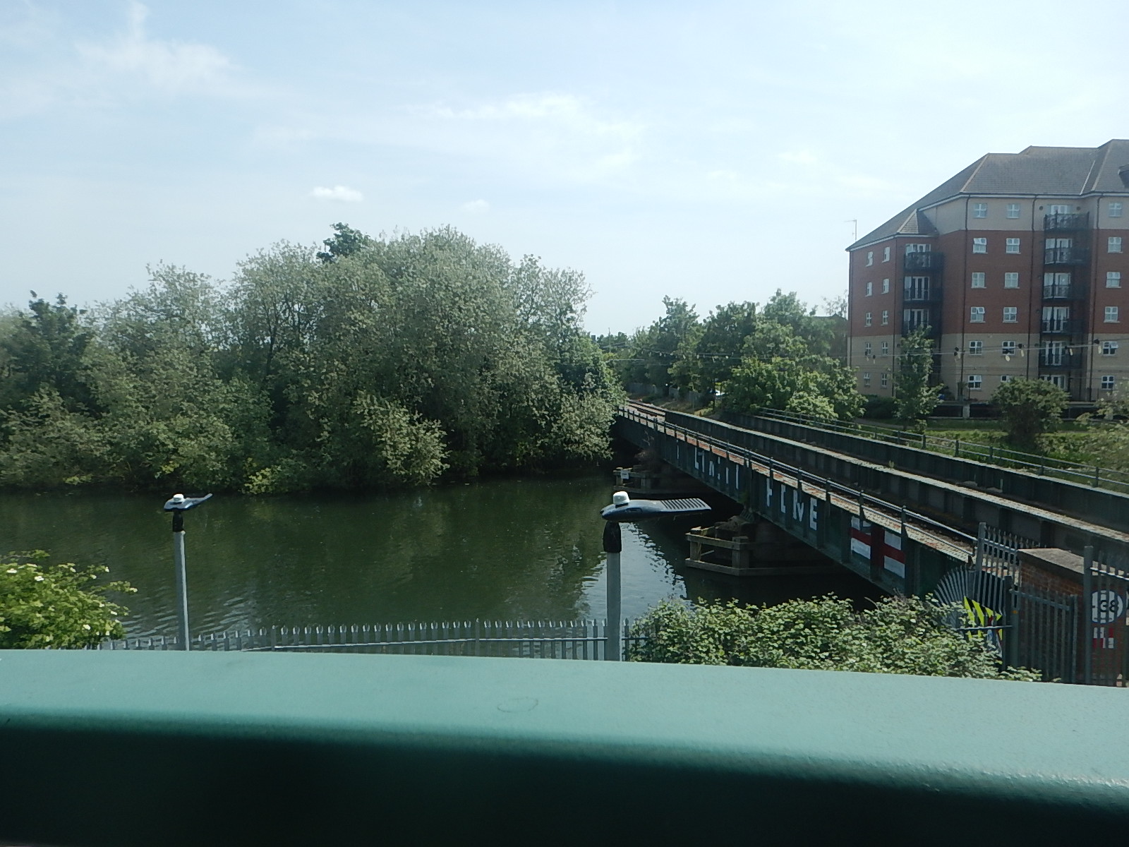
This picture shows the electrified track as it crosses over the river.
Could Platform 1A be ideal for handling and charging, battery-electric trains, that terminate in Bedford station?
It’s odd that there is the same platform layout at both ends of the Marston Vale Line.
Is it just a coincidence or does Engineer Baldrick have a cunning Plan?
Oxford Station
This OpenRailwayMap shows the platforms and the electrification around Oxford station.
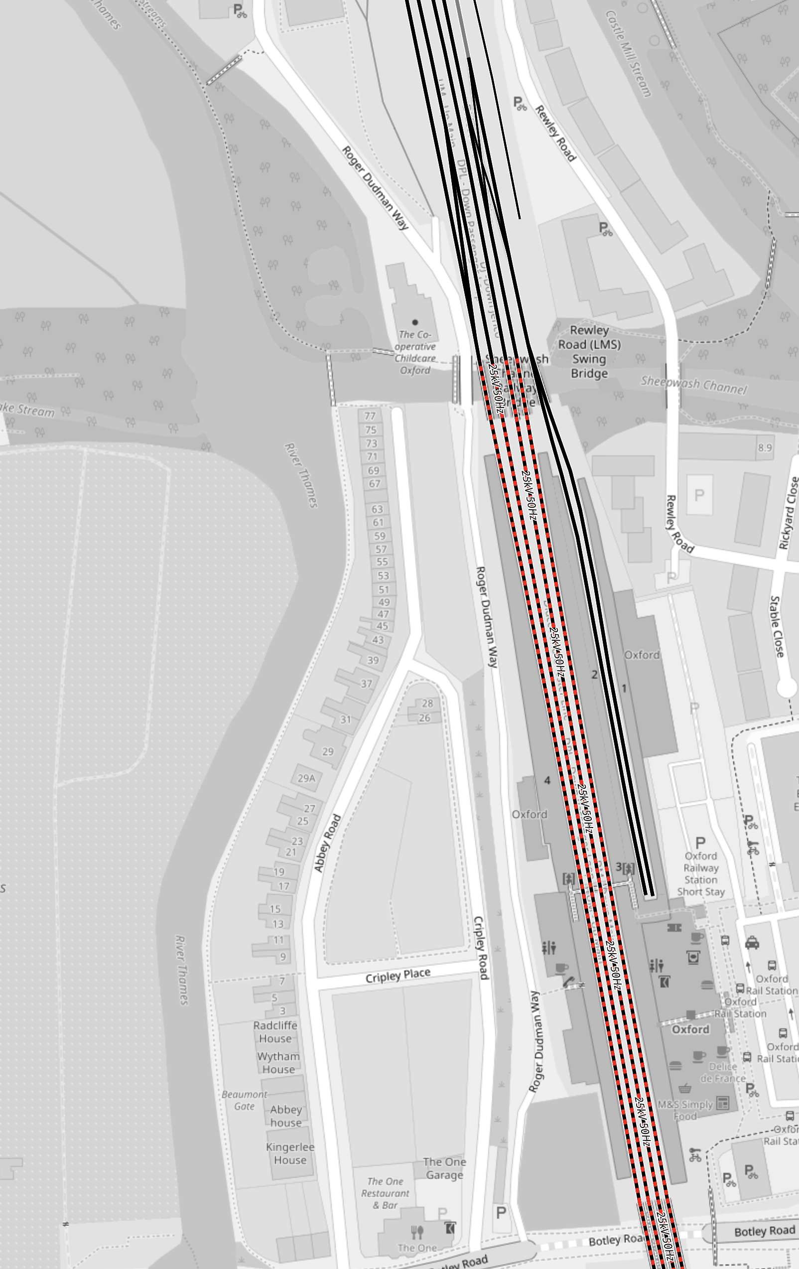
Note.
- The dotted red and black tracks, indicate electrification is planned.
- The planned electrification will connect Oxford station to Didcot Junction station.
- The two bay platforms at the North of the station are not electrified and Platform 2 is now used by Chiltern’s London services.
- Platform 1 could be used by trains on the East West Railway that terminate at Oxford.
When Oxford station is electrified, it wouldn’t be the largest project to add 25 KVAC overhead electrification to the two bay platforms.
Aylesbury Station
This OpenRailwayMap shows the platforms and the lack of electrification around Aylesbury station.
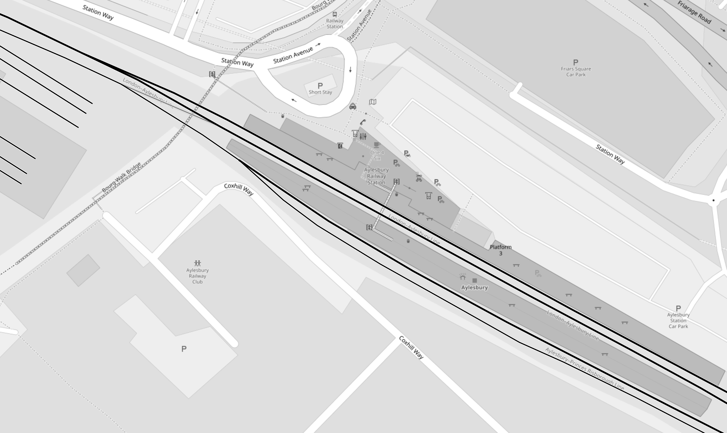
Note.
- No tracks are electrified.
- Platforms are numbered 3, 2, 1 from the top, so 2 and 3 are paired in the middle.
- All freight trains go through Platform 2 and most seem to go via Princes Risborough and High Wycombe.
- Chiltern services use Platforms 1 and 3.
Putting a charging system in Aylesbury station could be tricky.
I wonder if the simplest system for East West Railway would be to electrify between Aylesbury and Aylesbury Vale Parkway stations.
Chiltern Railway’s time between the two stations is as much as seven minutes.
Some trains to Aylesbury take over twenty minutes to do the short journey to Aylesbury Vale Parkway and return, which is more than enough to fully-charge a battery-electric train.
You can even have Chiltern’s hourly Aylesbury Parkway service, sharing the same stretch of electrification with East West Railway’s Aylesbury service, as there is a loop, which creates double-track for some of the way.
It should be noted that between Marylebone and Aylesbury Vale Parkway stations is only 41.1 miles, so some battery-electric trains could do that with a full charge at one end.
East West Railway Distances
In Trains Needed For The East West Railway, I calculated some of these distances.
- Oxford and Bedford – 46.8 miles
- Oxford and Milton Keynes – 33.4 miles
- Aylesbury and Milton Keynes – 25.9 miles
With charging at both ends, all of these routes are possible using modern battery-electric trains, where even a Class 777 IPEMU, designed for extending Merseyrail’s suburban network has done 84 miles on one charge.
On To Cambridge
In this document on the East-West Rail Consortium web site, these services are suggested, for when the East West Railway is complete.
- An hourly train via Norwich terminating at Great Yarmouth.
- An hourly train via Ipswich terminating at Manningtree.
These are distances on these routes that are not electrified, that are to the East of Cambridge.
- Ely and Norwich – 53.7 miles
- Norwich and Great Yarmouth – 18.3 miles
- Cambridge and Haughley Junction – 40.3 miles
Note.
- The Manningtree service would be able to charge its batteries after passing Haughley junction going East and it would be nearly an hour before it needed to use the battery for traction.
- If the Yarmouth service could handle the full route on batteries, then it could return to Cambridge with an efficient charger at Great Yarmouth, which for 25 KVAC overhead electrification trains is an off the shelf item.
- But it does look to me that the trains must leave Cambridge with full batteries, so they can reach electrification at Bedford, Haughley or Norwich.
This map shows the route of the East West Railway between Bedford and Cambridge.
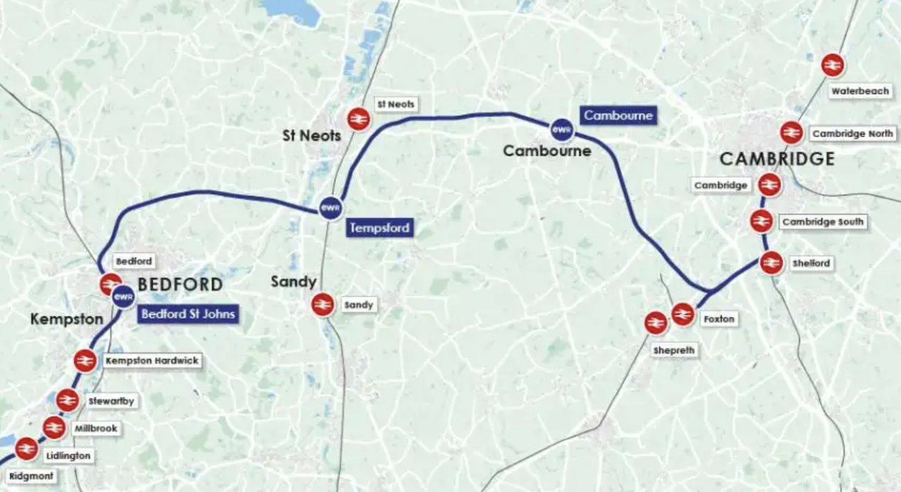
Note.
- Bedford is on the electrified Midland Main Line to London.
- Tempsford is on the electrified East Coast Main Line to London.
- Cambridge has two electrified main lines to London.
- These connections should ensure a good power supply to the East of Bedford for electrification.
I suspect the easiest option will be to add some more electrification at one or more of these places.
- At the Eastern end of the Bedford and Cambridge section.
- To the West of Haughley junction, when it is rebuilt.
- To the North of Ely, when the railways in that area are improved.
Although, as it will be a new route, it might be best to build Bedford and Cambridge as an electrified railway.
East-West Rail: Along The Marston Vale Line
For the initial phase of the East West Railway, it doesn’t appear that the Marston Vale Line will be improved.
As I write this, I have not heard of any improvements between Bedford and Bletchley.
Perhaps, with all the arguments about the section of the East West Railway between Bedford and Cambridge, the Government, Network Rail and the East West Railway feel that the best approach, is to do what they can with the existing track layout and the rebuilt viaduct at Bletchley.
These are my thoughts.
The Capacity Of The Marston Vale Line
In the Wikipedia entry for the Marston Vale Line, this is said about the infrastructure of the line.
Apart from a short length of single track at both ends, the line is double track, and is not electrified. It has a loading gauge of W8 and a line speed of 60 miles per hour (97 km/h). The line’s signalling centre is at Ridgmont.
The line has a length of only 16.5 miles.
I believe with modern signalling and well-trained drivers, that the line could accommodate at least two trains per hour (tph) in both directions.
At its simplest every half hour, a train would leave both end stations and the two trains would pass each other on the long double-track section in the middle.
Proposed Train Services
Train services on the East West Railway will be as follows, when it opens between Oxford and Milton Keynes and Bedford, are proposed to be as follows.
- 2 tph – East West Railway – Oxford and Milton Keynes Central via Oxford Parkway, Bicester Village, Winslow and Bletchley
- 1 tph – East West Railway – Oxford and Bedford via Oxford Parkway, Bicester Village, Winslow, Bletchley, Woburn Sands and Ridgmont
- 1 tph – West Midlands Trains – Bletchley and Bedford via Fenny Stratford, Bow Brickhill, Woburn Sands, Aspley Guise, Ridgmont, Lidlington, Millbrook, Stewartby, Kempston Hardwick and Bedford St Johns
If the East West Railway uses the Marston Vale Line between Bletchley and Bedford, then there will be two tph along the Marston Vale Line.
I believe that if the Marston Vale Line is not improved until later, then the proposed initial train service pattern can be achieved.
The New Bletchley Viaduct
The tracks appear to have been laid on the Bletchley Viaduct.
This Google Map shows the tracks on the viaduct.
Note.
- The double-track viaduct runs North-South in the middle of the map.
- The two platforms appear to be substantially complete.
- The two lift and stair towers are at the Southern end of the platforms.
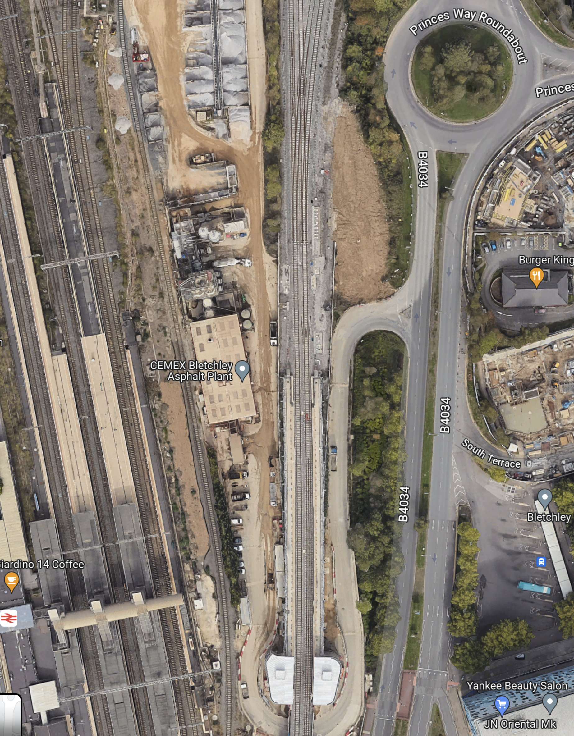
This second Google Map shows the section of the viaduct by the roundabout.
Note.
- The viaduct splits with two tracks going North-West to Milton Keynes Central and two tracks going North-East to Bedford.
- There is a complicated junction, which appears to allow a lot of flexibility for train operations.
I have followed the Milton Keynes tracks and there are cross-overs, so that trains can go between Platform 2A at Milton Keynes Central station and either of the viaduct platforms at Bletchley station, which they will need to do to run services between Oxford and Aylesbury, and Milton Keynes Central.
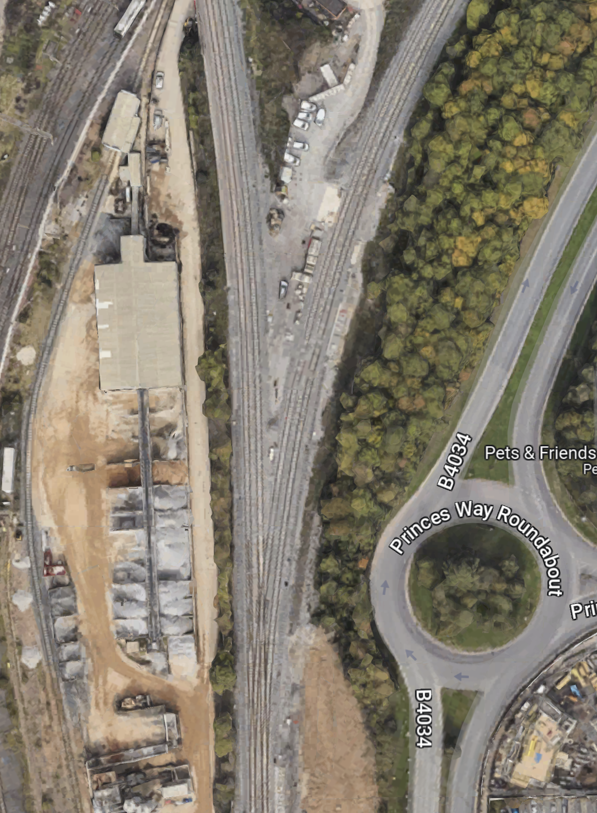
This Google Map shows the tracks between the viaduct and Fenny Stratford, which is the first station towards Bedford.
Note.
- The Princes Way roundabout in the West of the map.
- The Milton Keynes and Bedford tracks divide close to the roundabout.
- Fenny Stratford station in the East of the map.
- The tracks gradually combine from West to East, so there is only one track for the single platform at Fenny Stratford station.
This Google Map shows the Western section of the tracks between the viaduct and Fenny Stratford.
Note, how the two tracks on the viaduct join into one for going towards Fenny Stratford in the North-East corner of the map..
I’m certain, that this track layout, allows a train to go between the single platform at Fenny Stratford station and either of the viaduct platforms at Bletchley station.
A Milton Keynes Central And Bedford Service
In the Wikipedia entry for the Marston Vale Line, there is a section, which is entitled Extension to Milton Keynes Central, where this is said.
In June 2005, the then franchisee, Silverlink Trains announced an intention to extend the Marston Vale service via the West Coast Main Line to Milton Keynes Central, where a new platform and track would be built alongside the up slow track. Work began on 4 December 2006 at the station to prepare for a service connection. The platform was ready for use in January 2009 but the service did not materialise and there are no longer any published plans for it to do so. A firm service pattern on East West Rail remains to be announced but the illustrative pattern has no Bedford–Milton Keynes Central service; passengers will continue to have to change at Bletchley. There is no east-to-north chord between this line and the WCML: As of December 2020, the route the chord might take is occupied by trade outlets and a warehouse.
But.
Supposing a Milton Keynes to Bedford train did this.
- It ran from Platform 2A at Milton Keynes Central to the Northbound platform on the Bletchley viaduct.
- It would then reverse and run to Bedford along the Marston Vale Line.
- It would terminate in Platform 1A at Bedford station.
And supposing a Bedford to Milton Keynes train did this.
- It ran from Platform 1A at Bedford to the Northbound platform on the Bletchley viaduct.
- It would then reverse and run to Milton Keynes Central along the tracks alongside the West Coast Main Line.
- It would terminate in Platform 2A at Milton Keynes Central station.
Note.
- There would be some bi-directional running.
- Trains would only reverse on the Northbound platform on the Bletchley viaduct.
- Platform 2A at Milton Keynes Central would handle 4 tph.
- Platform 1A at Bedford station would handle 2 tph.
As the only reversing happens on the Northbound platform on the Bletchley viaduct, would it be sensible for a new driver to step-up, so that the reverse was fast?
I believe that with some innovative running, that a Milton Keynes and Bedford service is possible, because of the comprehensive track layout that has been installed.
East-West Rail: Through Bedford
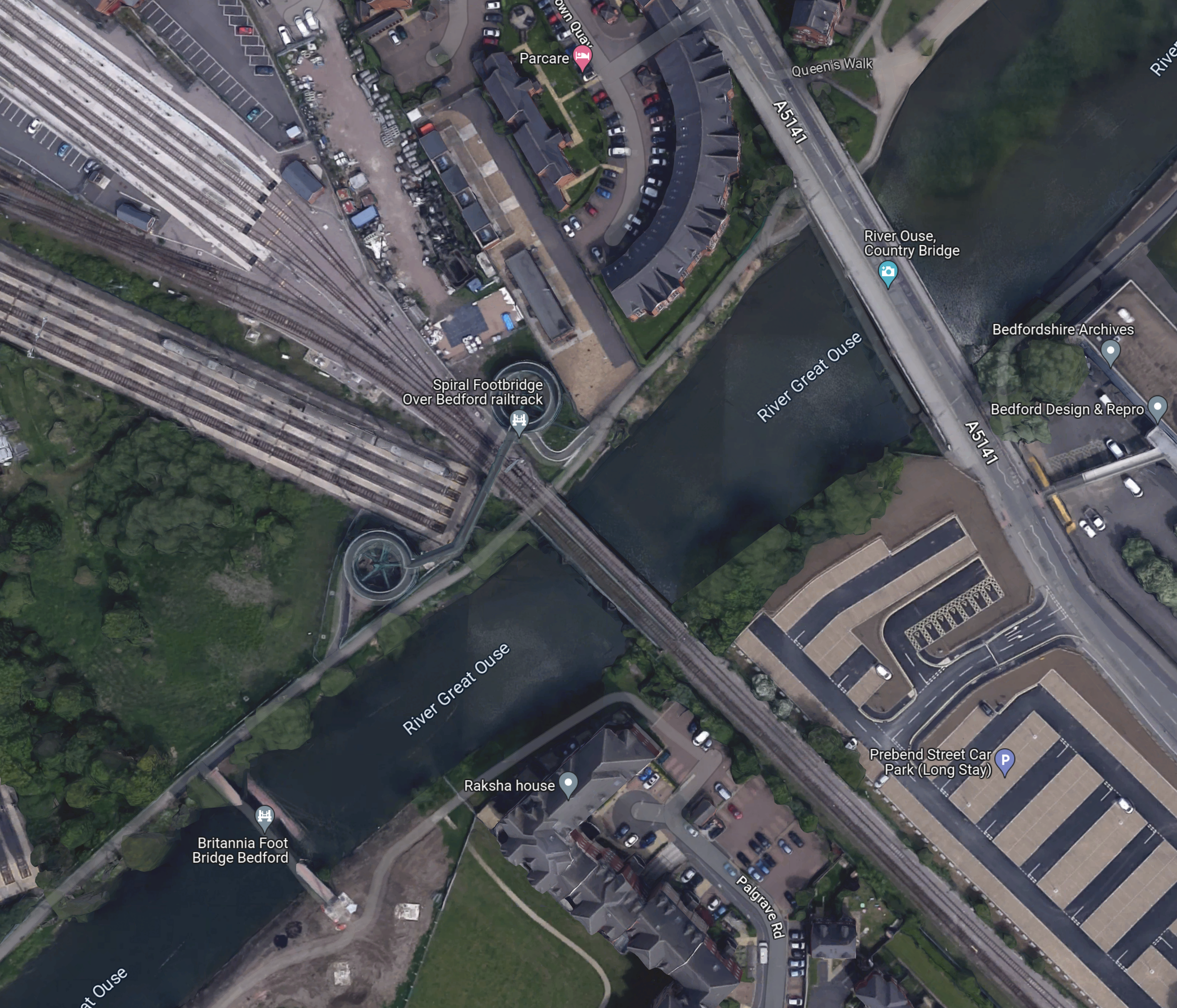
This Google Map shows the route of East West Rail through Bedford.
Note.
- Bedford St. Johns station in the South-East corner of the map.
- Bedford station is in the North-West corner of the map.
- Tracks run between the two stations to allow Marston Vale Line trains to terminate in Platform 1A at Bedford station.
- There are a lot of sidings for Thameslink trains South of Bedford station.
- The Great Ouse divides the town into two.
I’ll now explore further.
Bedford St. Johns Station
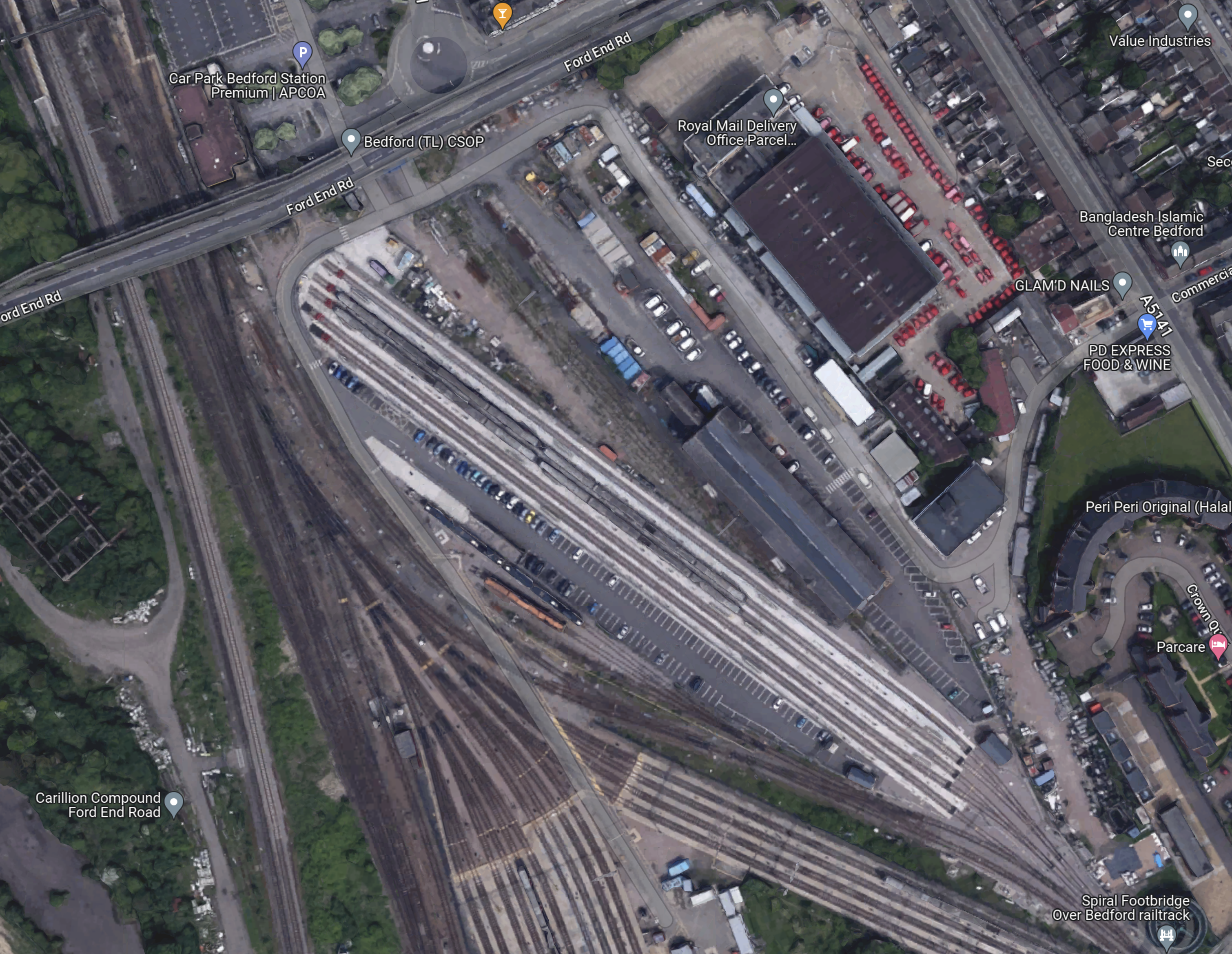
This Google Map shows Bedford St. Johns station.
Note.
- Bedford St. Johns station towards the North-East corner of the map.
- The single-track Marston Vale Line passing through the station.
- The track becomes double track to the North of the station.
- Although not shown on the map, the Marston Vale Line becomes double track to the South of the station.
- If it was all double-track, this would surely make operation of the Marston Vale Line easier for two trains per hour (tph).
- In the South-West of the map is Bedford hospital.
The Wikipedia entry for Bedford St. Johns station, says this about the future of the station.
In March 2021, plans were unveiled which, if taken forward, would see Bedford St Johns railway station relocated as the track through the station will be realigned. In May 2023, EWRL announced that it proposes to relocate the station further north (to Kempston Road) to better serve Bedford Hospital.
That sounds sensible, as it would allow either a full two-platform step-free station or a smaller single-sided one-platform station to be built.
Over The Great Ouse
This Google Map shows the railway crossing the Great Ouse.
Note.
- The Marston Vale Line runs to the South -West of the long-stay car park in the South-East corner of the map.
- The Western bridge takes the line over the Great Ouse.
- It then runs between the sidings to Bedford station.
This picture, which was taken from the Spiral Footbridge on the North bank of the Ouse, shows the double-track rail bridge.
There are two tracks all the way from where the single-track divides to the North of Bedford St. Johns station.
The Southern Approaches To Bedford Station
This Google Map shows the Southern approaches to Bedford station.
I have looked at the track layout and I’m fairly sure of the following.
- Current Marston Vale trains can go directly into Platform 1A without crossing any other tracks.
- Marston Vale trains can use Platform 1 if required.
- Thameslink trains can terminate in Platforms 1, 2 or 3.
- Southbound Corby trains can call in Platforms 1, 2 or 3.
- If they stop in Platforms 1 or 2, they appear to cross over South of Bedford station to the Midland Main Line.
If 2 tph were running on the Marston Vale Line; one fast and one stopping, a single platform should be able to handle the trains, if it was long enough.
Bedford Station
These pictures show Bedford station.

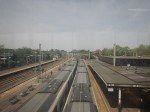

Note.
- The first two pictures were taken from the footbridge.
- The fast line between Platforms 3 and 4, is clearly visible in the second picture.
- Platform 1A is electrified.
This Google Map shows Platform 1A, where Marston Valley Line trains currently terminate.

Note.
- Platforms from the right are 1A and 1, 2 and 3 on the islands, with 4 to the left.
- Judging it against the three cars of the train in Platform 2, I reckon that Platform 1A could be updated to hold a six-car train.
Would a six-car train be long enough?
Initial East West Rail Services To Bedford
According to the Wikipedia entry for the East West Railway, these services will run on the railway between Oxford and Bedford.
- East West Railway – Oxford and Milton Keynes Central via Oxford Parkway, Bicester Village, Winslow and Bletchley – 2 tph
- East West Railway – Oxford and Bedford via Oxford Parkway, Bicester Village, Winslow, Bletchley, Woburn Sands and Ridgmont – 1 tph
- East West Railway – Aylesbury and Milton Keynes Central via Aylesbury Vale Parkway, Winslow and Bletchley – 1 tph
- West Midlands Trains – Bletchley and Bedford via Fenny Stratford, Bow Brickhill, Woburn Sands, Aspley Guise, Ridgmont, Lidlington, Millbrook, Stewartby, Kempston Hardwick and Bedford St Johns – 1 tph
Note.
- tph is trains per hour.
- There a fast train and a stopping train between Bletchley and Bedford.
- It appears that both these trains could terminate in Platform 1A at Bedford station.
I believe this will be possible with the current track layout, as the Marston Vale Line is almost all double-track.
East West Rail Services To Cambridge And Beyond
In this document on the East-West Rail Consortium web site, these services are suggested, for when the East West Rail is complete.
- An hourly train via Norwich terminating at Great Yarmouth.
- An hourly train via Ipswich terminating at Manningtree.
Would this mean three of four passenger tph on the Marston Vale Line?
If Cambridge and Oxford services, were running under digital signalling, I suspect trains could cross between the Thameslink and Marston Vale Lines, so that they could call in the through platforms at Bedford station.
How Would Trains Connect To The East At Bedford Station?
This Google Map shows the Midland Main Line through Bedform.
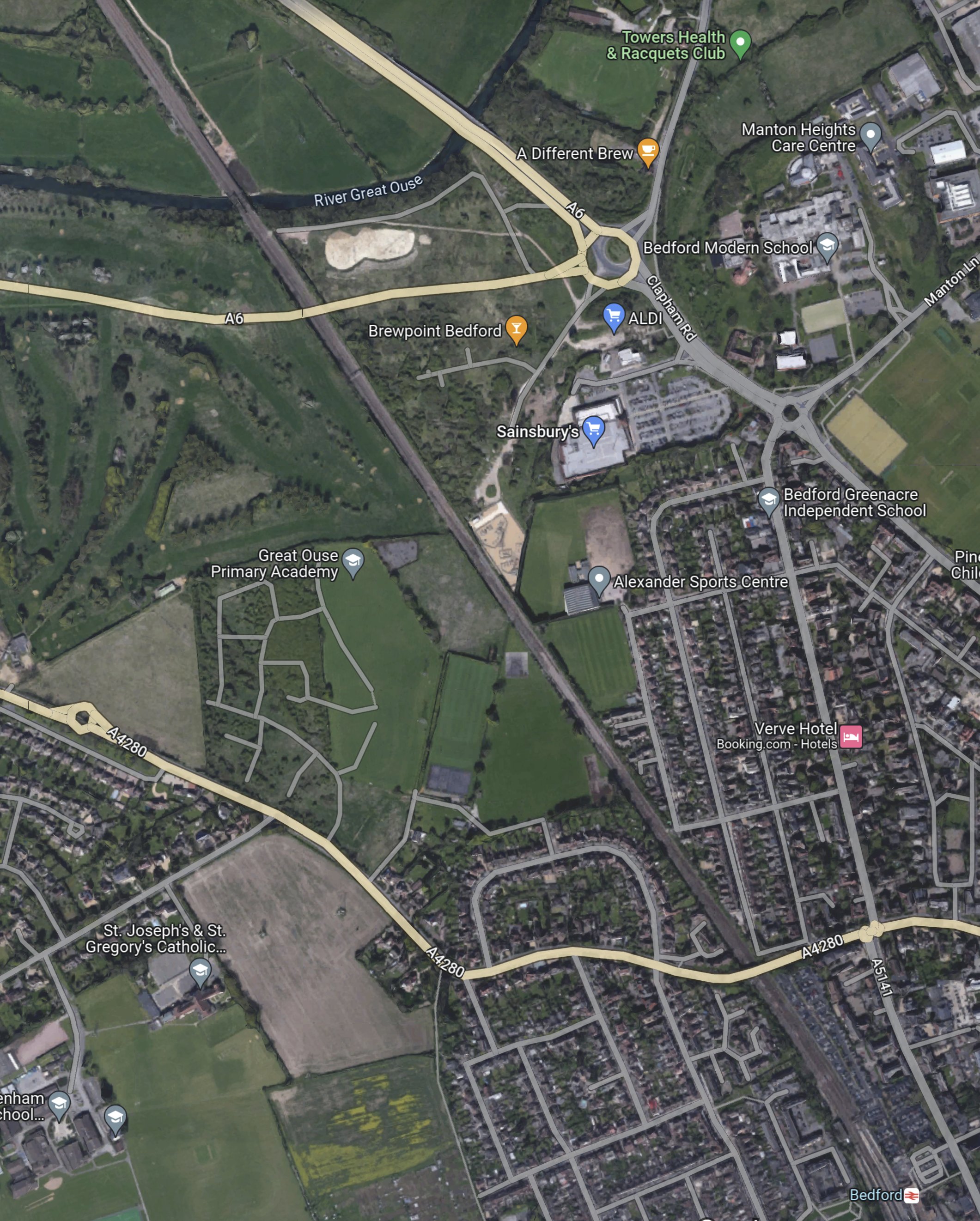
Note.
- Bedford station in the South-East corner of the map.
- The Midland Main Line runs diagonally from Bedford station across the map.
- The A6 seems to take a curious route in the North-West corner of the map, where it connects to a roundabout with an Aldi and a Sainsbury’s
This Google Map shows the countryside to the North-East of the roundabout.
Judging by the colours of the fields to the North-East of the roundabout, I suspect, that a high proportion of the land is in one ownership.
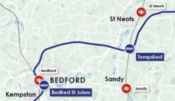
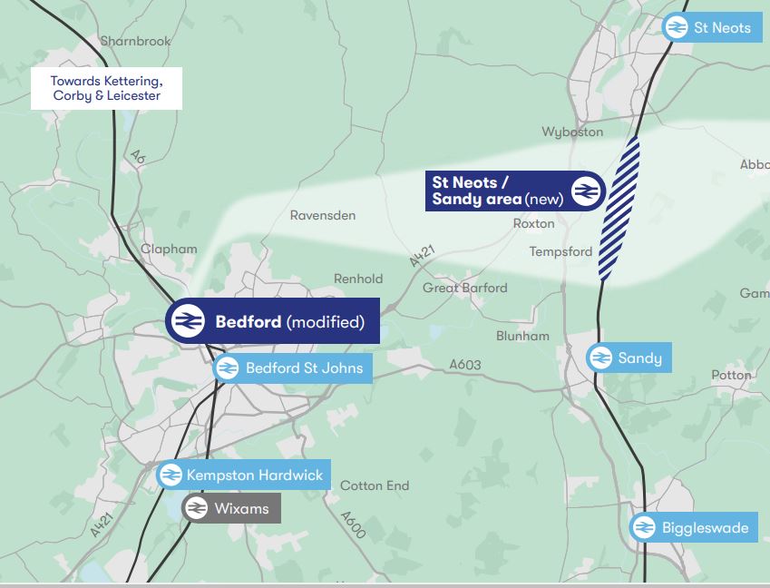
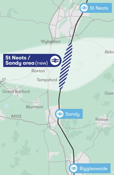
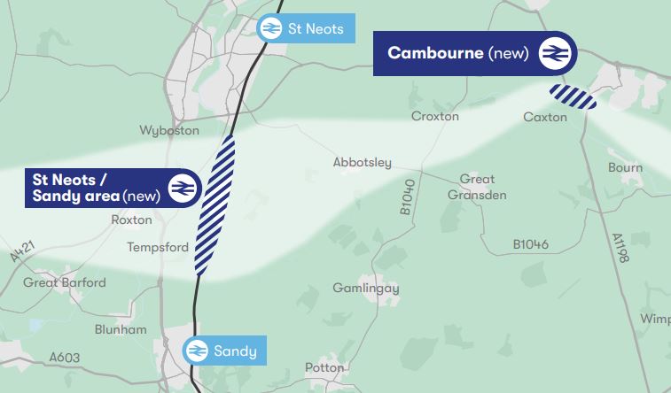
This map clipped from the East West Rail route map, shows the route between Bedford and the East Coast Main Line between St. Neots and Sandy stations.
This Google Map shows the area of the junction, that would connect the East West Rail tracks to the slow lines through Bedford station.
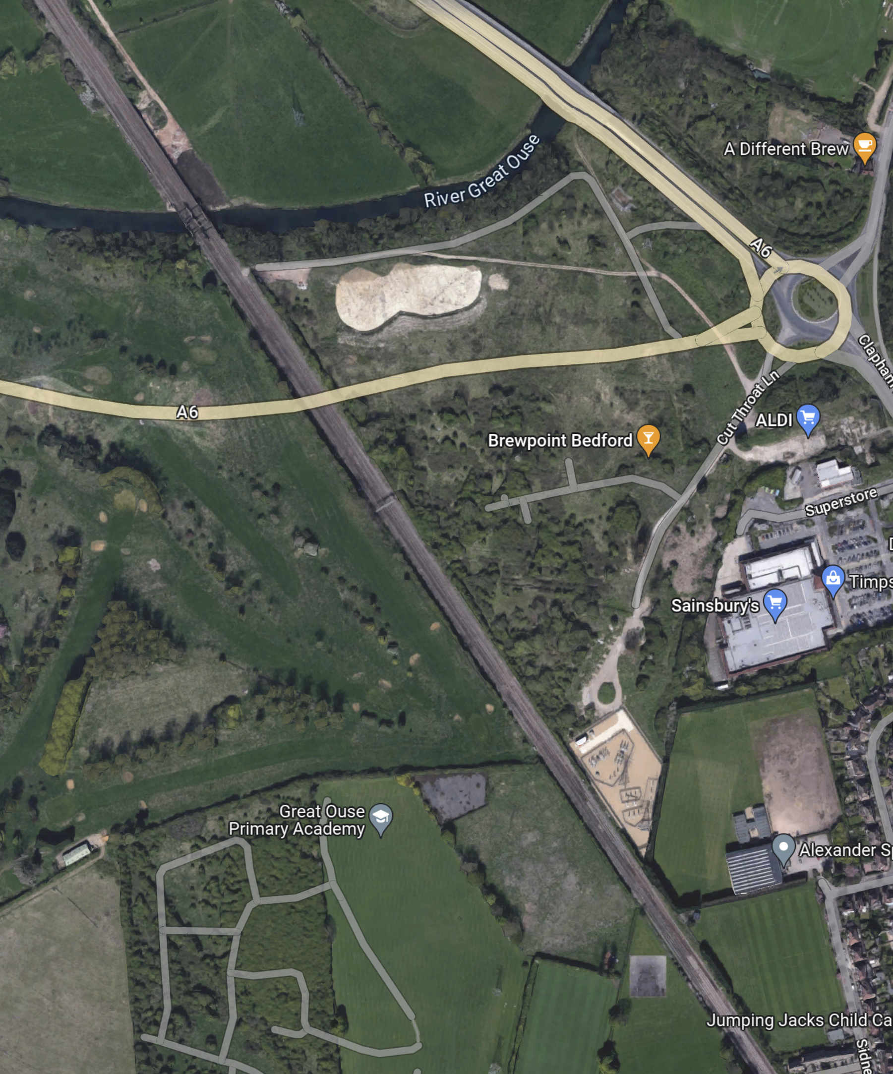
Note.
- The four-track Midland Main Line runs diagonally across the map.
- The beige-coloured diamond-shaped area by the railway is an electrical substation.
- There doesn’t appear to be many properties that would need to be demolished.
- There would need to be a viaduct over the A6.
- Once over the A6, the land seems to be in one ownership, which should ease building the railway across.
I feel it would be feasible, possibly with the use of a dive-under or flyover to connect the East West Rail tracks to the slow lines through Bedford station.
East-West Rail: Oxford And Bedford
This map from East West Rail shows the route between Oxford and Bedford.
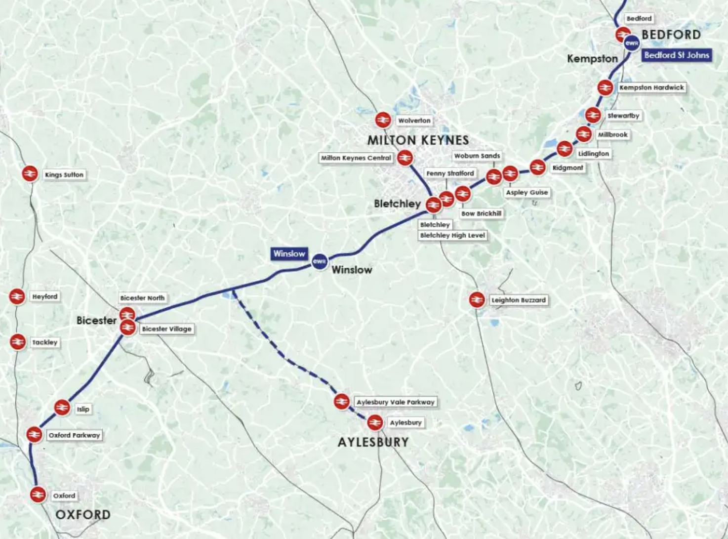
Note.
- The proposed route is shown in blue.
- The possible Southern extension to Aylesbury is shown dotted.
- The route between Bicester and Bletchley is rebuilt track along a former alignment.
- The route between Bletchley and Bedford will surely be rebuilt track along the Marston Vale Line.
- The Bicester and Bedford sections of track will be joined by the Bletchley Flyover, which is well on the way to completion.
This Google Map shows Bletchley station.

Note.
- Bletchley Station has six platforms.
- The double-track Bletchley Flyover runs North-South at the Eastern side of the station.
- There are the beginnings of two platforms on the flyover, which will increase the number of platforms at Bletchley station to eight.
- There is a junction at the Northern end of the flyover, where one pair of tracks go North to Milton Keynes Central and the other takes the Marston Vale Line to Bedford.
The track-layout at Bletchley station allows trains between Oxford and Bedford and Oxford and Milton Keynes Central to call at Bletchley station.
Proposed Passenger Trains Between Oxford and Bedford
According to the Wikipedia entry for the East West Railway, these service will run on the railway between Oxford and Bedford.
- East West Railway – Oxford and Milton Keynes Central via Oxford Parkway, Bicester Village, Winslow and Bletchley – 2 tph
- East West Railway – Oxford and Bedford via Oxford Parkway, Bicester Village, Winslow, Bletchley, Woburn Sands and Ridgmont – 1 tph
- East West Railway – Aylesbury and Milton Keynes Central via Aylesbury Vale Parkway, Winslow and Bletchley – 1 tph
- West Midlands Trains – Bletchley and Bedford via Fenny Stratford, Bow Brickhill, Woburn Sands, Aspley Guise, Ridgmont, Lidlington, Millbrook, Stewartby, Kempston Hardwick and Bedford St Johns – 1 tph
Note.
- tph is trains per hour.
- All larger stations get at least a half-hourly service.
- There are three tph between Oxford and Bletchley via Oxford Parkway, Bicester Village and Winslow.
- There a fast train and a stopping train between Bletchley and Bedford.
- It is still undecided, whether provision will be made for the Aylesbury service.
I think that this service pattern is achievable, with or without the Aylesbury service.
Fed Up Council Threatens Injunction Against Network Rail Over Closure Of Milton Keynes Railway Crossing
The title of this post, is the same as that of this article on the Milton Keynes Citizen.
This looks like the ultimate level crossing argument between a council and Network Rail.
In some ways it’s all a bit ironic, as Network Rail’s headquarters is in Milton Keynes.
This Google Map shows the disputed crossing in Woburn Sands.
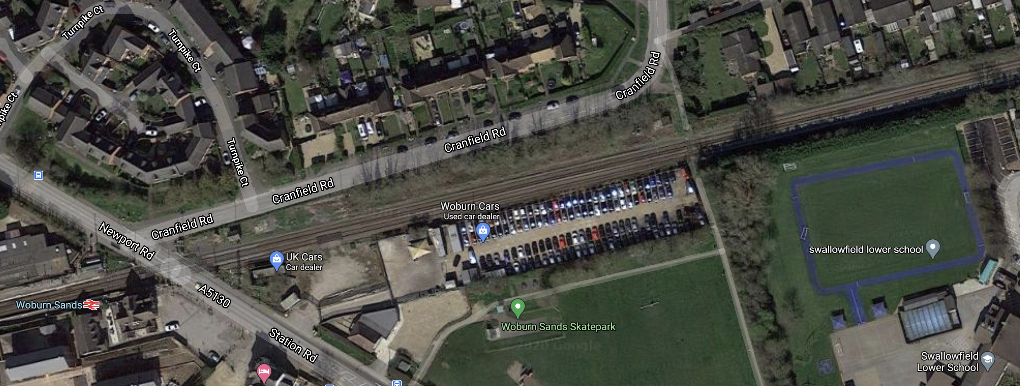
Note.
- The railway is the Marston Vale Line.
- Woburn Sands station and a level crossing is at the Western edge of the map.
- Swallowfield Lower School is at the Eastern edge of the map.
- Cranfield Road runs along the Northern side of the railway.
The row is all about the closure of the foot crossing, that links Cranfield Road and the school.
I live on a road to a primary school. At school times, there is heavy traffic on the pavement, with a lot of younger children in buggies and others with scooters.
- A lot of the younger children are probably not going to school, but are too young to be left at home, by themselves.
- I also see a couple of children in wheel-chairs.
I suspect the traffic to Swallowfield Lower school will be similar.
- A bridge over the railway with steps would not be an adequate solution.
- A bridge with lifts would be expensive.
- A bridge with ramps would probably be difficult to fit in the restricted site.
- A shallow subway with a ramp either side would probably be the only acceptable and affordable solution.
This picture shows such a subway at Enfield Lock station.
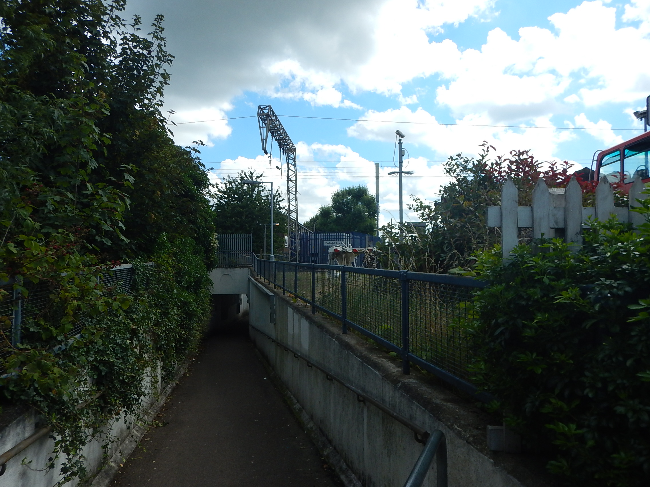
Could one like this, be dug under the railway at Woburn Sands?
Looking At The East West Railway Between Bedford And Cambridge
Updated Post
I have updated this post in June 2021 to add extra information, that has now become available.
The route that has been chosen by East West Railway is Route E.
Route E is described in Wikipedia as follows.
Route E involves running from the existing Bedford station heading north then running to Tempsford where a new station would be built then (bypassing Sandy) the route heads east to Cambourne where a new station would be built. The route then joins an existing line northbound to Cambridge.
These maps show the route between Bedford and Cambridge stations in sections.
Bedford And Tempsford
This map shows the Western section between Bedford and Tempsford.
Note.
- Kempston Hardwick and Bedford St. Johns are existing stations on the existing Marston Vale Line, which could substantially be the route of the East West Railway between Bedford and stations to the West like Bletchley, Milton Keynes, Oxford and Reading.
- Bedford station is on the Midland Main Line.
- Wixams station is a proposed station on the Midland Main Line, which also might be served by the East West Railway.
- Biggleswade, Sandy and St. Neots stations are on the East Coast Main Line (ECML).
I’ll now take a quick look at the route through Bedford and the proposed Wixams station.
Bedford Station
Bedford station is served by the following train services.
- It is a terminus for Marston Vale Line services to and from Bletchley station.
- It is a terminus for Thameslink services to and from London St. Pancras International station and the South as far as Brighton.
- East Midlands Railway services between London St. Pancras International station and the East Midlands and Sheffield call at the station.
Midlands Connect are also proposing a service between Bedford and Leeds.
- It would use High Speed Two Classic-Compatible trains.
- This would use High Speed Two to the North of East Midlands Hub station.
- Times would drop between Bedford and Leeds from 140 minutes to 66 minutes.
I wonder, if this service were to be successful, that more services could be run from Bedford to the North.
There would certainly be massive advantages in developing Bedford as a major interchange between the East West Railway and the Midland Main Line.
This Google Map shows Bedford station.
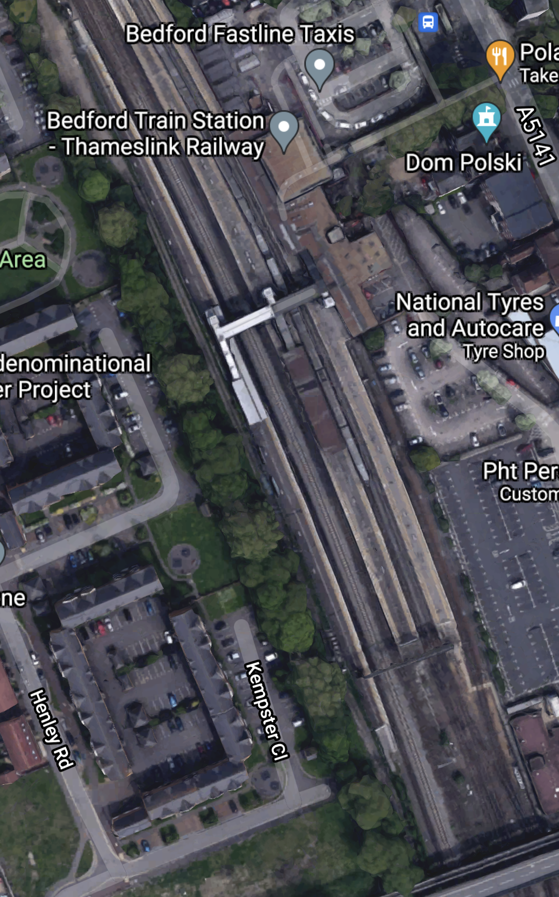
Bedford station currently has five platforms.
- 1a – A bay platform for Marston Vale Line services
- 1 and 2 – Thameslink
- 3 – Southbound East Midlands Railway
- 4 – Northbound East Midlands Railway
Note.
- Platform 1a is about a hundred metres long.
- There is a fast line between Platforms 3 and 4.
- There is space to the West of Platform 4
I can come to these conclusions about Bedford station.
If a new platform is needed to handle more services at the station, there is space to build it.
According to East West Railway Company To Start Second Phase Of Rolling Stock Procurement, three-car trains are to be used by the East West Railway and these can be handled by the current Platform 1a.
As Bedford station is to be rebuilt, any issues can be sorted.
This Google Map shows the area to the North of the station.
Note that some of the roads to the North-East of the railway are named after poets. This is the Poets area of Bedford.
This article on the BBC is entitled East-West Rail: Bedfordshire Residents Give Their Views On £5bn Scheme and it details the opposition to the route including a section about the Poets area.
EWR Co says it could acquire or demolish 53 properties in the Bromham Road district of Bedford, known as the Poets area.
In addition, a further 16 properties could be demolished between Bedford and Cambridge.
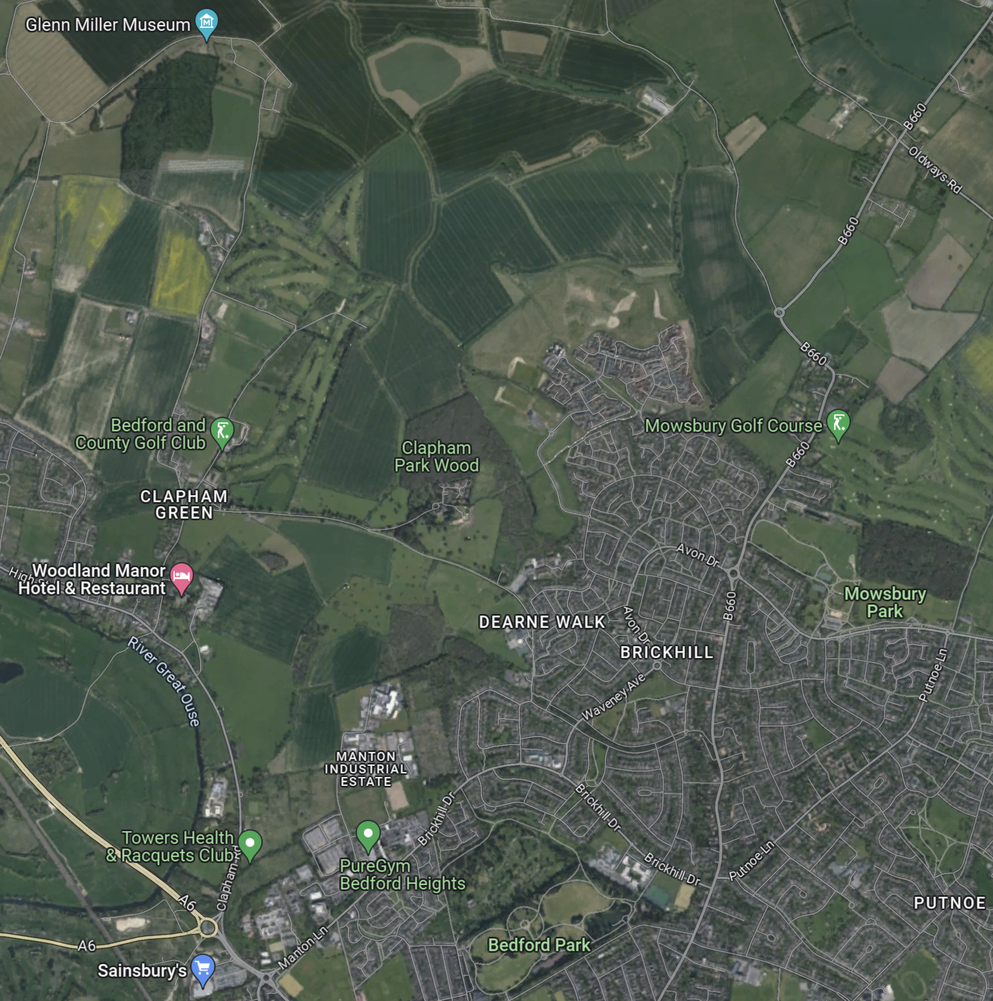
This Google Map shows the Midland Main Line through Bedford.
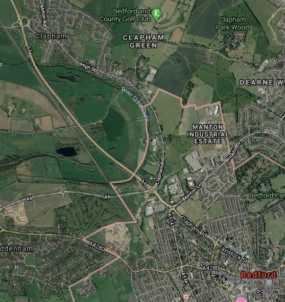
Note.
- Bedford station is at the bottom of the map towards the East.
- The village of Clapham is towards the top of the map.
- The A6 road runs up the Eastern side of the railway.
What I find interesting, is that, to the East of the Midland Main Line between Bedford and Clapham appears to be mainly open farmland.
Is there sufficient space to build a flying junction, so that trains could go between Bedford and Cambridge in a smooth manner? From a quick look at this map, it appears to me that this would be possible.
It might even be possible to build a full triangular junction, North of Bedford, so that trains could go between the East and the Northbound Midland Main Line.
It looks to me to be a very important junction, that gives lots of possibilities for new passenger and freight services.
- Passenger trains between Cambridge and Sheffield via Leicester and Derby.
- Freight trains between Felixstowe and Derby, Nottingham and Sheffield.
- Could the route be used for stone trains between the Peak District and the massive building developments in the City of London?
This ideas would be for starters!
But I do feel that Network Rail have lots of strong reasons to take a North-Easterly route out of Bedford.
But this route is not popular with those that live in the area.
This Google Map shows the area South of Bedford towards the Wixams development.
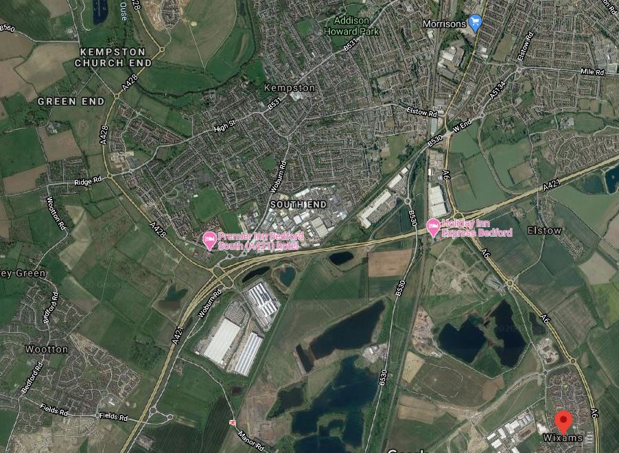
Note.
- The large new village of Wixams is shown by the red arrow.
- Kempston Hardwick station can be picked out to the West of Wixams, close to the bottom of the map.
- The Midland Main Line can be picked out running South between Wixams and Kempston Hardwick.
The area looks like it is ripe for housing and commercial development between all the water.
I can envisage the East West Railway and the Midland Main Line doing the following.
- Sharing tracks through Bedford and a new Wixams station, if that is desired.
- A flying junction would then allow the two routes to split.
- The East West Railway would go West to places like Bletchley, Milton Keynes, Oxford and Reading.
- The Midland Main Line would go South to Luton, London and beyond.
The East West Railway would open up a massive housing development at Wixams with connections to Cambridge, London, Milton Keynes, Oxford and beyond.
It strikes me, that one of the reasons for choosing Route E, is that this is the route, that opens up the Wixams development.
Could A Southern Route Be Used Around Bedford?
It probably could but, if the trains were to serve Bedford they’d need to reverse in Bedford station.
If the East West Railway goes to the North of Bedford, the following is possible.
- East West Railway trains going East could share Platform 4 with Northbound East Midlands Railway services.
- East West Railway trains going West could share Platform 3 with Southbound East Midlands Railway services.
- East West Railway trains going West could also have a cross-platform interchange with Thameslink.
Train operation would be much simpler.
Through Tempsford
This map shows the Western section around Tempsford, where it crosses the ECML.
Note.
- Biggleswade, Sandy and St. Neots stations are on the ECML.
- There might be opportunities to improve the section of the ECML in this area.
- The light-coloured East-West band through the new station, is the proposed route of the East West Railway.
This Google Map shows the area North from Sandy.
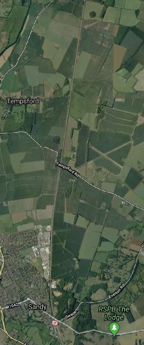
Note.
- Sandy station can be seen at the bottom of the map.
- Tempsford can be seen about three-quarters of the way up the map.
- The ECML runs North-South up the middle of the map.
- The former RAF Tempsford can also be seen on the East side of the ECML.
- One interesting place on the map is the RSPB at Sandy.
Has the route been chosen to the North of Sandy to avoid the RSPB, who might not be in favour of a new railway?
- I could envisage an impressive interchange station at Tempsford, if East West Railway decided to build it.
- The East West Railway and the ECML could cross at right angles.
- Platforms on both routes could be connected by lifts, escalators and stairs.
- There looks like there could be space for lots of car parking.
Alternatively, a full junction could be built so that trains could swap between the two routes. But I suspect this would be too expensive.
The View From St. Neots
This article on the BBC is entitled St Neots: ‘I Think This Could Put Our Town On The Map’.
This is the first paragraph.
For the first time in its 1,000 years of history, St Neots could get its own voice in Parliament as part of a reshuffle of constituency boundaries. What difference could it make for a town that is the largest in Cambridgeshire?
The This in in the title is their own MP.
This is also said about transport links in the town.
he town, which is 45 minutes to London by rail, is getting a new bypass and is also at the centre of the new Cambridge to Oxford east-west rail link.
“There are phenomenal opportunities here for new business, all this development is happening around us,” adds Mr Hughes.
“All the people who used to travel to London – because St Neots is a commuter town – during the pandemic, they’ve opened the door, walked into the town and realised there’s a wonderful bohemia here.
There are also complaints in the article about the lack of jobs.
Surely, if the new station at Tempsford was well-designed and had enough car-parking, some of those commuters could work in Cambridge.
Tempsford And Cambourne
This map shows the central section between Tempsford and Cambourne.
Note.
- Sandy and St. Neots stations are on the ECML.
- The light-coloured East-West band through the new Tempsford and Cambourne stations, is the proposed route of the East West Railway.
This Google Map shows the area between Tempsford and Cambourne.
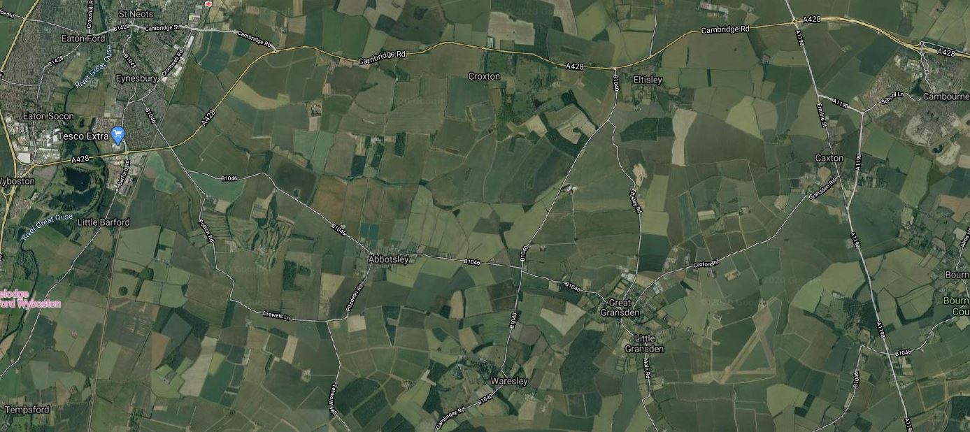
Note.
- Tempsford is in the South-West corner of the map.
- Cambourne is in the North-East corner of the map.
- St. Neots station is in the North-West corner of the map.
It certainly isn’t an area of the country with many important buildings around.
Through Cambourne
This Google Map shows the central section through Cambourne.
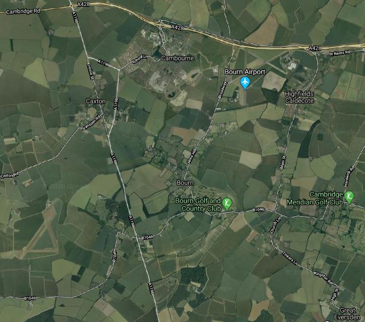
Note.
- The new village of Cambourne by the A428.
- The A1198 road going North-South between Huntingdon and Royston.
- The village of Great Eversden in the South-East corner of the map.
From looking at the various maps and knowing the area well, I suspect the East West Railway will take the following route.
- Approach from the West and cross the A1198 to the North of Caxton.
- Pass South of Cambourne, where a station could be built. The station could be fairly simple, but there is plenty of space, especially if cycling to the train is encouraged.
- Pass North of Bourn and Bourn Golf and Country Club.
- Pass North of Great Eversden and leave the map in the South-East corner.
It looks to be a fairly simple section.
Great Eversden And Cambridge
This Google Map shows the area from Great Eversden to the Trumpington Park-and-Ride, which is served by the Cambridgeshire Guided Busway.
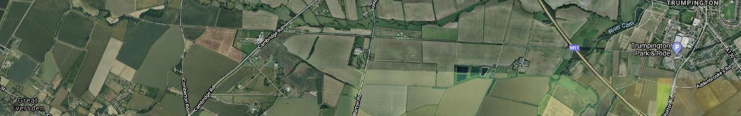
Note.
- Great Eversden is in the South-West corner of the map.
- The M11 runs diagonally across the Eastern end of the map.
- Trumpington is at the Eastern end of the map.
- The track bed of the old Varsity Line is clearly visible.
The question has to be asked, if it would be worthwhile rebuilding this section.
Consider.
- Part of the trackbed is used for the Ryle Telescope.
- Part of the trackbed is used for the Cambridgeshire Guided Busway.
- The route doesn’t serve Addenbrooke’s Hospital.
- Cambridge also has ambitions to extend the Cambridgeshire Guided Busway to Hauxton and create the Cambridge Autonomous Metro, which I wrote about in Consultation On The Cambridge Autonomous Metro.
This map shows the proposed layout of the Cambridgeshire Autonomous Metro.
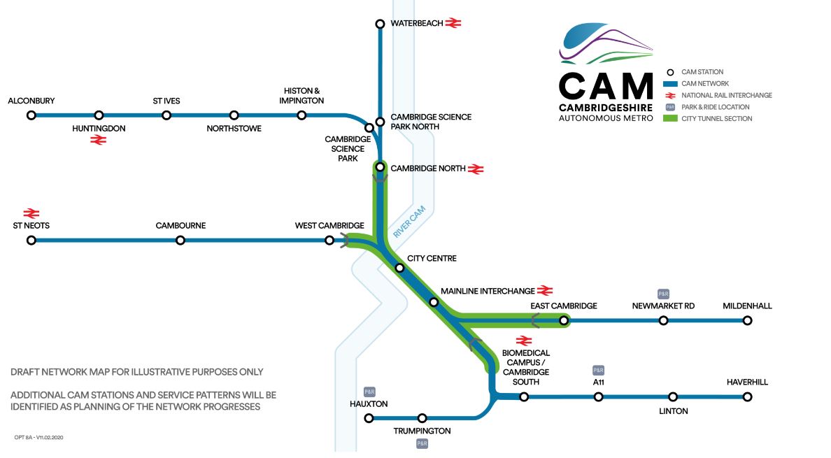
Note.
- The green section will be in tunnel.
- The Trumpington Branch is extended to Hauxton,
This Google Map shows the area to the South West of Cambridge between Hauxton and Addenbrooke’s Hospital.

Note.
- Addenbrooke’s Hospital is in the North-East corner of this map.
- The Trumpington Park-and-Ride is to the East of the M11.
- Shelford station is in the South-East corner of the map.
- The West Anglia Main Line running past the hospital, splits into two, with one branch going West to Royston and Hitchin and the other going South to Harlow and London.
The two maps taken together weave quite a complicated pattern.
The East West Railway and the Cambridge Autonomous Metro could probably be tweaked so that they could both be created.
- The East West Railway could take a slightly more Southerly route and pass to the West of Hauxton to join the Royston and Cambridge Line to get to Cambridge South and Cambridge stations.
- The Cambridge Autonomous Metro would pass over or under the M11 and terminate at a suitable place on the East of Hauxton.
There might even be a solution involving a joint station to the West of the M11
