Looking At The East West Railway Between Bedford And Cambridge
Updated Post
I have updated this post in June 2021 to add extra information, that has now become available.
The route that has been chosen by East West Railway is Route E.
Route E is described in Wikipedia as follows.
Route E involves running from the existing Bedford station heading north then running to Tempsford where a new station would be built then (bypassing Sandy) the route heads east to Cambourne where a new station would be built. The route then joins an existing line northbound to Cambridge.
These maps show the route between Bedford and Cambridge stations in sections.
Bedford And Tempsford
This map shows the Western section between Bedford and Tempsford.
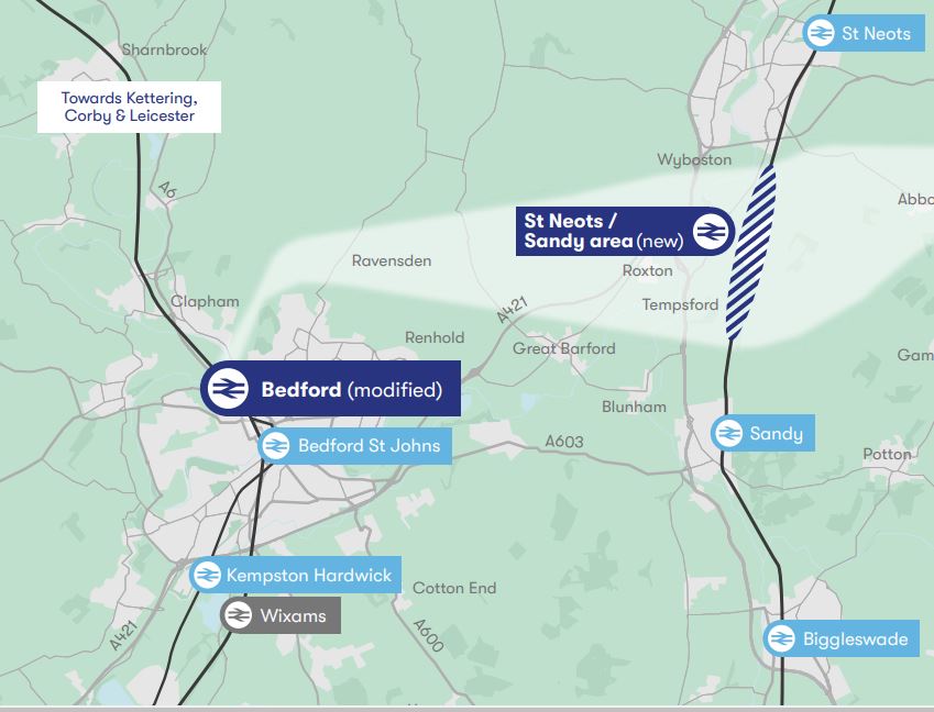
Note.
- Kempston Hardwick and Bedford St. Johns are existing stations on the existing Marston Vale Line, which could substantially be the route of the East West Railway between Bedford and stations to the West like Bletchley, Milton Keynes, Oxford and Reading.
- Bedford station is on the Midland Main Line.
- Wixams station is a proposed station on the Midland Main Line, which also might be served by the East West Railway.
- Biggleswade, Sandy and St. Neots stations are on the East Coast Main Line (ECML).
I’ll now take a quick look at the route through Bedford and the proposed Wixams station.
Bedford Station
Bedford station is served by the following train services.
- It is a terminus for Marston Vale Line services to and from Bletchley station.
- It is a terminus for Thameslink services to and from London St. Pancras International station and the South as far as Brighton.
- East Midlands Railway services between London St. Pancras International station and the East Midlands and Sheffield call at the station.
Midlands Connect are also proposing a service between Bedford and Leeds.
- It would use High Speed Two Classic-Compatible trains.
- This would use High Speed Two to the North of East Midlands Hub station.
- Times would drop between Bedford and Leeds from 140 minutes to 66 minutes.
I wonder, if this service were to be successful, that more services could be run from Bedford to the North.
There would certainly be massive advantages in developing Bedford as a major interchange between the East West Railway and the Midland Main Line.
This Google Map shows Bedford station.
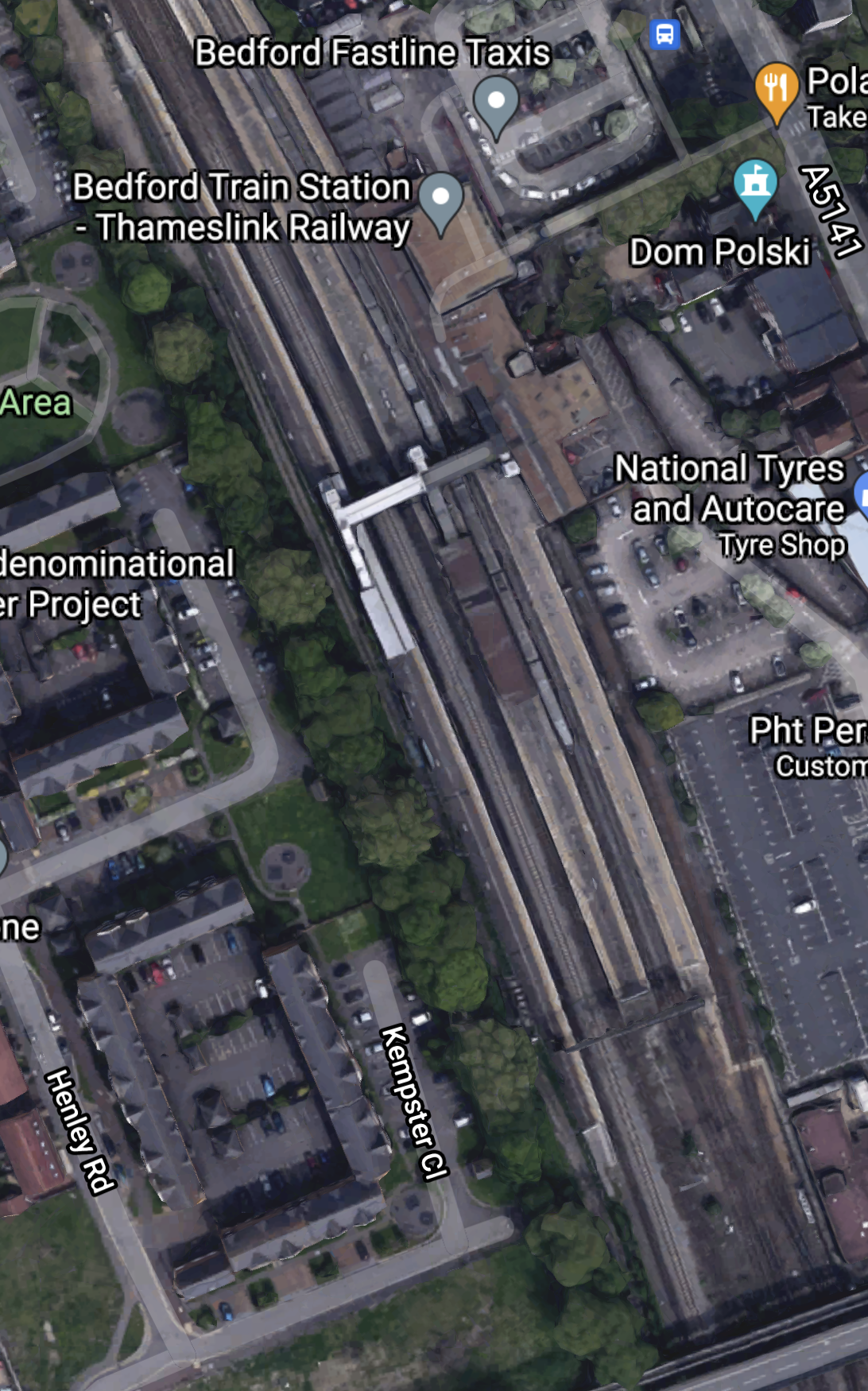
Bedford station currently has five platforms.
- 1a – A bay platform for Marston Vale Line services
- 1 and 2 – Thameslink
- 3 – Southbound East Midlands Railway
- 4 – Northbound East Midlands Railway
Note.
- Platform 1a is about a hundred metres long.
- There is a fast line between Platforms 3 and 4.
- There is space to the West of Platform 4
I can come to these conclusions about Bedford station.
If a new platform is needed to handle more services at the station, there is space to build it.
According to East West Railway Company To Start Second Phase Of Rolling Stock Procurement, three-car trains are to be used by the East West Railway and these can be handled by the current Platform 1a.
As Bedford station is to be rebuilt, any issues can be sorted.
This Google Map shows the area to the North of the station.
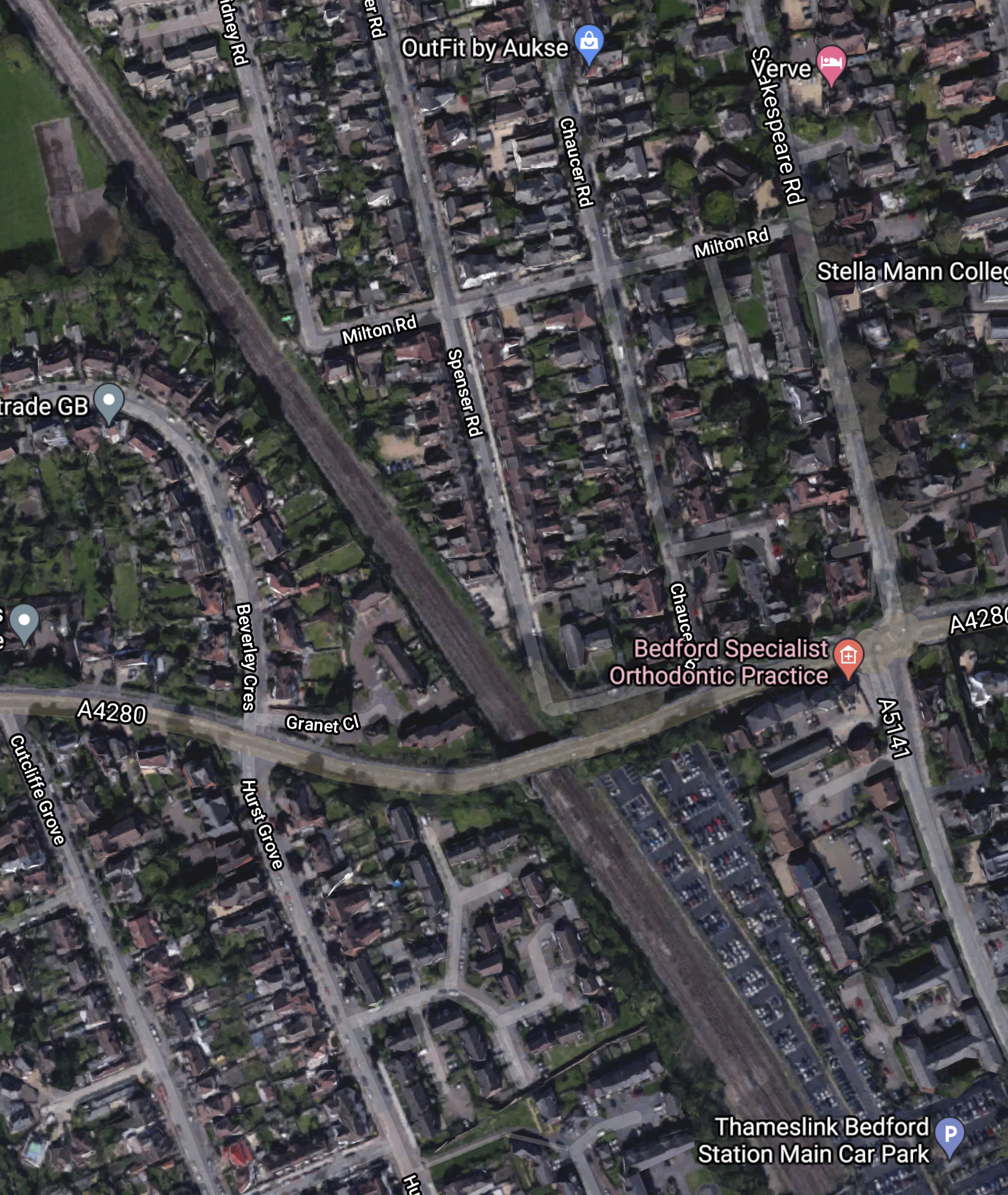
Note that some of the roads to the North-East of the railway are named after poets. This is the Poets area of Bedford.
This article on the BBC is entitled East-West Rail: Bedfordshire Residents Give Their Views On £5bn Scheme and it details the opposition to the route including a section about the Poets area.
EWR Co says it could acquire or demolish 53 properties in the Bromham Road district of Bedford, known as the Poets area.
In addition, a further 16 properties could be demolished between Bedford and Cambridge.
This Google Map shows the Midland Main Line through Bedford.
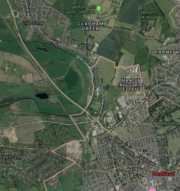
Note.
- Bedford station is at the bottom of the map towards the East.
- The village of Clapham is towards the top of the map.
- The A6 road runs up the Eastern side of the railway.
What I find interesting, is that, to the East of the Midland Main Line between Bedford and Clapham appears to be mainly open farmland.
Is there sufficient space to build a flying junction, so that trains could go between Bedford and Cambridge in a smooth manner? From a quick look at this map, it appears to me that this would be possible.
It might even be possible to build a full triangular junction, North of Bedford, so that trains could go between the East and the Northbound Midland Main Line.
It looks to me to be a very important junction, that gives lots of possibilities for new passenger and freight services.
- Passenger trains between Cambridge and Sheffield via Leicester and Derby.
- Freight trains between Felixstowe and Derby, Nottingham and Sheffield.
- Could the route be used for stone trains between the Peak District and the massive building developments in the City of London?
This ideas would be for starters!
But I do feel that Network Rail have lots of strong reasons to take a North-Easterly route out of Bedford.
But this route is not popular with those that live in the area.
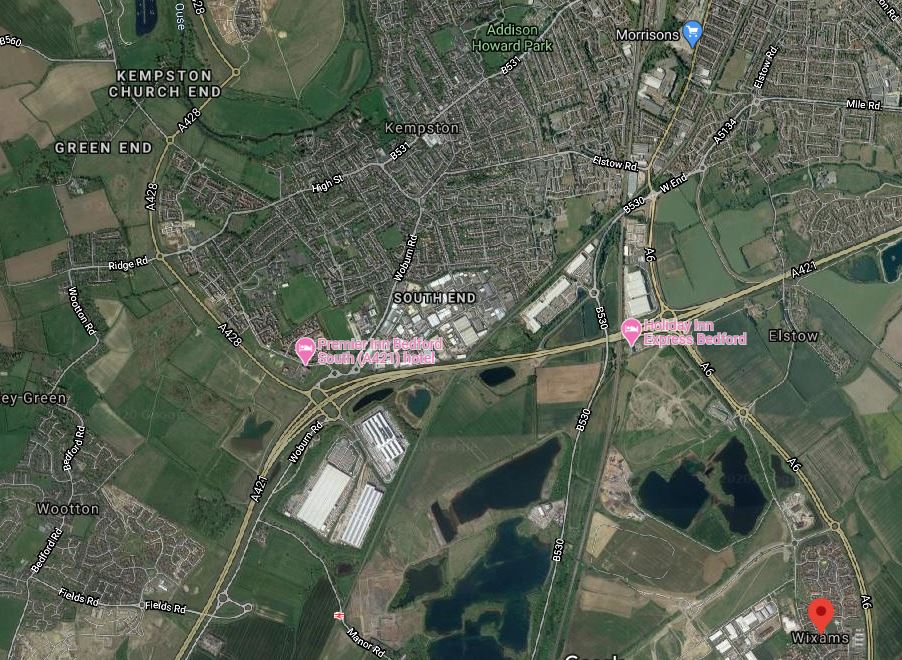
This Google Map shows the area South of Bedford towards the Wixams development.
Note.
- The large new village of Wixams is shown by the red arrow.
- Kempston Hardwick station can be picked out to the West of Wixams, close to the bottom of the map.
- The Midland Main Line can be picked out running South between Wixams and Kempston Hardwick.
The area looks like it is ripe for housing and commercial development between all the water.
I can envisage the East West Railway and the Midland Main Line doing the following.
- Sharing tracks through Bedford and a new Wixams station, if that is desired.
- A flying junction would then allow the two routes to split.
- The East West Railway would go West to places like Bletchley, Milton Keynes, Oxford and Reading.
- The Midland Main Line would go South to Luton, London and beyond.
The East West Railway would open up a massive housing development at Wixams with connections to Cambridge, London, Milton Keynes, Oxford and beyond.
It strikes me, that one of the reasons for choosing Route E, is that this is the route, that opens up the Wixams development.
Could A Southern Route Be Used Around Bedford?
It probably could but, if the trains were to serve Bedford they’d need to reverse in Bedford station.
If the East West Railway goes to the North of Bedford, the following is possible.
- East West Railway trains going East could share Platform 4 with Northbound East Midlands Railway services.
- East West Railway trains going West could share Platform 3 with Southbound East Midlands Railway services.
- East West Railway trains going West could also have a cross-platform interchange with Thameslink.
Train operation would be much simpler.
Through Tempsford
This map shows the Western section around Tempsford, where it crosses the ECML.
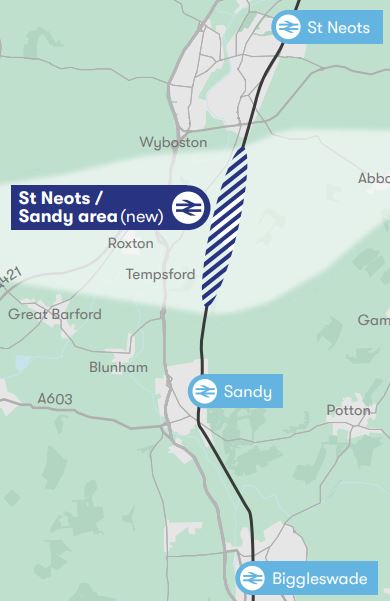
Note.
- Biggleswade, Sandy and St. Neots stations are on the ECML.
- There might be opportunities to improve the section of the ECML in this area.
- The light-coloured East-West band through the new station, is the proposed route of the East West Railway.
This Google Map shows the area North from Sandy.
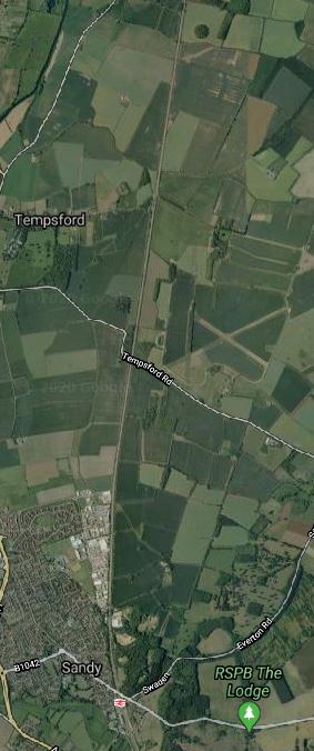
Note.
- Sandy station can be seen at the bottom of the map.
- Tempsford can be seen about three-quarters of the way up the map.
- The ECML runs North-South up the middle of the map.
- The former RAF Tempsford can also be seen on the East side of the ECML.
- One interesting place on the map is the RSPB at Sandy.
Has the route been chosen to the North of Sandy to avoid the RSPB, who might not be in favour of a new railway?
- I could envisage an impressive interchange station at Tempsford, if East West Railway decided to build it.
- The East West Railway and the ECML could cross at right angles.
- Platforms on both routes could be connected by lifts, escalators and stairs.
- There looks like there could be space for lots of car parking.
Alternatively, a full junction could be built so that trains could swap between the two routes. But I suspect this would be too expensive.
The View From St. Neots
This article on the BBC is entitled St Neots: ‘I Think This Could Put Our Town On The Map’.
This is the first paragraph.
For the first time in its 1,000 years of history, St Neots could get its own voice in Parliament as part of a reshuffle of constituency boundaries. What difference could it make for a town that is the largest in Cambridgeshire?
The This in in the title is their own MP.
This is also said about transport links in the town.
he town, which is 45 minutes to London by rail, is getting a new bypass and is also at the centre of the new Cambridge to Oxford east-west rail link.
“There are phenomenal opportunities here for new business, all this development is happening around us,” adds Mr Hughes.
“All the people who used to travel to London – because St Neots is a commuter town – during the pandemic, they’ve opened the door, walked into the town and realised there’s a wonderful bohemia here.
There are also complaints in the article about the lack of jobs.
Surely, if the new station at Tempsford was well-designed and had enough car-parking, some of those commuters could work in Cambridge.
Tempsford And Cambourne
This map shows the central section between Tempsford and Cambourne.
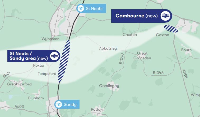
Note.
- Sandy and St. Neots stations are on the ECML.
- The light-coloured East-West band through the new Tempsford and Cambourne stations, is the proposed route of the East West Railway.
This Google Map shows the area between Tempsford and Cambourne.
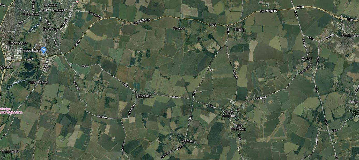
Note.
- Tempsford is in the South-West corner of the map.
- Cambourne is in the North-East corner of the map.
- St. Neots station is in the North-West corner of the map.
It certainly isn’t an area of the country with many important buildings around.
Through Cambourne
This Google Map shows the central section through Cambourne.
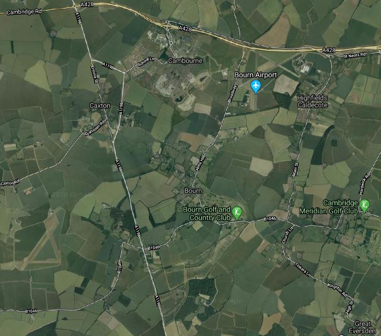
Note.
- The new village of Cambourne by the A428.
- The A1198 road going North-South between Huntingdon and Royston.
- The village of Great Eversden in the South-East corner of the map.
From looking at the various maps and knowing the area well, I suspect the East West Railway will take the following route.
- Approach from the West and cross the A1198 to the North of Caxton.
- Pass South of Cambourne, where a station could be built. The station could be fairly simple, but there is plenty of space, especially if cycling to the train is encouraged.
- Pass North of Bourn and Bourn Golf and Country Club.
- Pass North of Great Eversden and leave the map in the South-East corner.
It looks to be a fairly simple section.
Great Eversden And Cambridge
This Google Map shows the area from Great Eversden to the Trumpington Park-and-Ride, which is served by the Cambridgeshire Guided Busway.
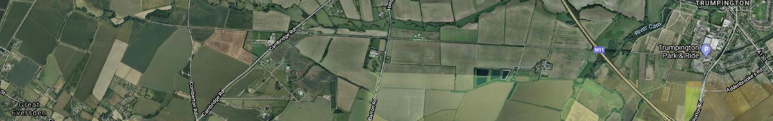
Note.
- Great Eversden is in the South-West corner of the map.
- The M11 runs diagonally across the Eastern end of the map.
- Trumpington is at the Eastern end of the map.
- The track bed of the old Varsity Line is clearly visible.
The question has to be asked, if it would be worthwhile rebuilding this section.
Consider.
- Part of the trackbed is used for the Ryle Telescope.
- Part of the trackbed is used for the Cambridgeshire Guided Busway.
- The route doesn’t serve Addenbrooke’s Hospital.
- Cambridge also has ambitions to extend the Cambridgeshire Guided Busway to Hauxton and create the Cambridge Autonomous Metro, which I wrote about in Consultation On The Cambridge Autonomous Metro.
This map shows the proposed layout of the Cambridgeshire Autonomous Metro.
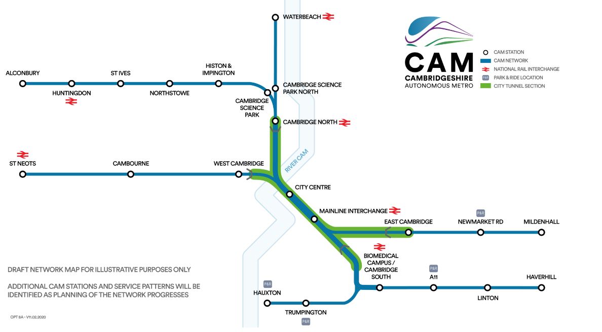
Note.
- The green section will be in tunnel.
- The Trumpington Branch is extended to Hauxton,
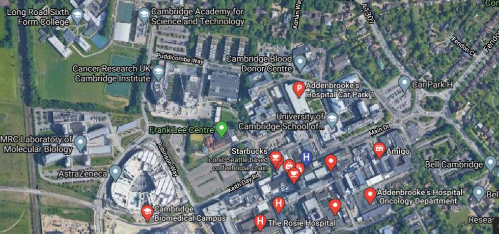
This Google Map shows the area to the South West of Cambridge between Hauxton and Addenbrooke’s Hospital.

Note.
- Addenbrooke’s Hospital is in the North-East corner of this map.
- The Trumpington Park-and-Ride is to the East of the M11.
- Shelford station is in the South-East corner of the map.
- The West Anglia Main Line running past the hospital, splits into two, with one branch going West to Royston and Hitchin and the other going South to Harlow and London.
The two maps taken together weave quite a complicated pattern.
The East West Railway and the Cambridge Autonomous Metro could probably be tweaked so that they could both be created.
- The East West Railway could take a slightly more Southerly route and pass to the West of Hauxton to join the Royston and Cambridge Line to get to Cambridge South and Cambridge stations.
- The Cambridge Autonomous Metro would pass over or under the M11 and terminate at a suitable place on the East of Hauxton.
There might even be a solution involving a joint station to the West of the M11
Cambridge South Station To Be Developed
To me, this was one of the highlights of the 2020 Budget today.
As I lived near Cambridge for over a dozen years and regularly played real tennis at the University, I know the scientific heartbeat of the City better than most.
I have discussed the problems of running a business in the City, with many, who are associated with some of the City’s most successful businesses. I have also funded several ventures in the area.
The same basic problems keep arising.
- Lack of premises, offices and workshops, of all sizes and qualities.
- Lack of staff to work in the ventures.
- Lack of suitable housing, where staff moving to the City can live.
- Staff are being forced to live further out and the roads, railways and other pubic transport systems don’t have the capacity.
- Inadequate connections to Stansted Airport.
In the last few years, the transport has improved.
- A sophisticated and award-winning Park-and-Ride running to five large car parks ringing the City has been developed.
- The Park-and-Ride also caters for cyclists.
- Cambridge North station has been opened close to the Cambridge Science Park and the A14 Cambridge Northern By-Pass, with a 450-space car-park and space for a thousand bikes.
- The Cambridge Guided Busway has been developed across the City from Huntingdon station to Trumpington via Cambridge Science Park, Cambridge North station, Cambridge City Centre, Cambridge bus station, Cambridge station and Addenbrooke’s Hospital.
- Addwnbrooke’s Hospital is a Major Trauma Centre.
- The forecourts of Cambridge and Cambridge North stations have been developed to create good interchanges and meeting points.
- Great Northern now has two fast and two stopping trains per hour (tph) between London Kings Cross and Cambridge and/or Cambridge North stations, with trains continuing alternatively half-hourly to Ely or Kings Lynn.
- Thameslink has two tph between Brighton and Cambridge.
- Thameslink also has two tph between Cambridge and London Kings Cross, which will be extended to Maidstone East station, within a couple of years.
- Greater Anglia run an hourly service between Norwich and Stansted Airport via Ely, Cambridge North and Cambridge stations.
- Greater Anglia run two tph between London Liverpool Street and Cambridge North stations.
- Greater Anglia run an hourly service between Ipswich and Cambridge via Bury St. Edmunds and Newmarket stations.
- All Greater Anglia trains are being replaced with new and much larger Class 755 or Class 720 trains.
- CrossCountry run an hourly service between Birmingham New Street and Stansted Airport via Peterborough, March, Ely, Cambridge North and Cambridge stations.
- The A14 and A428 roads are being improved between Cambridge and the A1.
- The East West Railway between Reading and Cambridge via Oxford, Milton Keynes and Bedford is being developed and should open before the end of the decade.
But Cambridge still needs better links to the surrounding countryside and further.
- Connections to Peterborough could be doubled to hourly.
- Cnnections to Haverhill and Wisbech are poor.
- East West Railway have ideas about improving connections to both East and West of Cambridge.
- Better connections are needed at Addenbrooke’s to connect the rail system to the hospital and the Cambridge Biomedical Campus.
Cambridge South station would be the icing on the cake.
- It could be the Southern terminus of a Wisbech service.
- It could be on a service of at least four tph between Ely and Cambridge South stations via Waterbeach, Cambridge North and Cambridge stations.
- It would bring Addenbrooke’s and the Cambridge Biomedical Campus within easy commuting of London.
- It would be well-connected to Bedford, London, Milton Keynes, Oxford, Reading, Stansted Airport and Stevenage.
- There have also been rumours, that the station could be connected to the Cambridge Autonomous Metro, which would be developed from the Cambridgeshire Guided Busway and the Park-and-Ride.
Cambridge South station would be the hub, that ties all the various routes together,
The station could be a fairly simple station to build, by just building platforms and buildings alongside the existing electrified line.
This Google Map shows the hospital. and the West Anglia Main Line running North-South to the West of the hospital.
Note the West Anglia Main Line running North-South to the West of the hospital.
Station Design
This page on the Network Rail web site gives a basic design.
- Four platforms with step-free access via a footbridge and lifts;
- Platforms with seating and shelter for waiting passengers;
- A ticket office and ticket machines, along with automatic ticket gates;
- Taxi and passenger drop off facilities:
- Facilities such as a retail/catering unit, a waiting room and toilets;
- Blue badge parking; and
- Cycle parking.
The page then gives various location options.
Services
These are my take on the initial services, based on the current ones and those proposed by the East West Railway.
- 1 tph – CrossCountry – Birmingham New Street and Stansted Airport, via Coleshill Parkway, Nuneaton, Leicester, Melton Mowbray, Oakham, Stamford, Peterborough, March, Ely, Cambridge North, Cambridge, Cambridge South and Audley End.
- 1 tph – Greater Anglia – Norwich and Stansted Airport, via Wymondham, Attleborough, Thetford, Brandon, Lakenheath, Ely, Cambridge North, Cambridge, Cambridge South, Whittlesford Parkway and Audley End.
- 1 tph – Greater Anglia – Ipswich and Cambridge South via Needham Market, Stowmarket, Bury St. Edmunds, A14 Parkway, Newmarket and Cambridge.
- 2 tph – Greater Anglia – Cambridge North and London Liverpool Street via Cambridge, Cambridge South, Audley End, Bishops Stortford, Harlow, Broxbourne and Cheshunt.
- 1 tph – Greater Anglia – Wisbech and Cambridge South via March, Ely, Cambridge North and Cambridge.
- 2 tph – Thameslink – Cambridge and Brighton via Stevenage, London St. Pancras, East Croydon and Gatwick Airport.
- 2 tph – Thameslink – Cambridge and Maidstone East via Stevenage, London St. Pancras and Blackfriars
- 2 tph – Great Northern – Ely/Kings Lynn and London Kings Cross via Stevenage.
- 1 tph – East West Railway – Norwich and Reading or Oxford, via Ely, Cambridge North, Cambridge, Cambridge South, Bedford and Milton Keynes.
- 1 tph – East West Railway – Manningtree and Reading or Oxford, via Ipswich, Needham Market, Stowmarket, Bury St. Edmunds, A14 Parkway, Newmarket, Cambridge, Cambridge South, Bedford and Milton Keynes
Note.
- I have left out a few less important stations.
- I have extended the current Ipswich and Cambridge service to Cambridge South.
- I have added East West Rail’s proposed A14 Parkway station.
- I have added a Wisbech and Cambridge South service.
This simple service gives the following frequencies.
- 6 tph – Ely and Cambridge North
- 8 tph – Cambridge North and Cambridge
- 10 tph – Cambridge and Cambridge South
- 2 tph – Cambridge/Cambridge South and Stansted Airport
- 1 tph – Cambridge North/Cambridge/Cambridge South and Kings Lynn
- 8 tph – Cambridge/Cambridge South and London
- 2 tph – Cambridge/Cambridge South and Ipswich.
- 2 tph – Cambridge North/Cambridge/Cambridge South and Norwich.
- 1 tph – Cambridge North/Cambridge/Cambridge South and Peterborough.
- 6 tph – Cambridge/Cambridge South and Stevenage.
I feel strongly about the following.
- If six tph is thought to be ideal between Cambridge/Cambridge South and Stevenage, then surely more services are needed between Cambridge and Ipswich, Kings Lynn, Norwich. Peterborough and Stansted Airport. Perhaps as many as four tph are needed to give a Turn-Up-And-Go service.
- The frequency through Ely, Cambridge North, Cambridge and Cambridge should be as high as possible. With digital signalling ten tph must be possible.
At least Greater Anglia have plenty of Class 755 trains.
Conclusion
Rishi Sunak is right to build Cambridge South station.
You might even be able to argue, that the work done on the Cambridge Biomedical Campus could be key in fighting diseases like the coronavirus.
Consultation On The Cambridge Autonomous Metro
Issue 900 of Rail Magazine has an article called Have Your Say On Plans For Cambridge Metro Network.
These are the introductory paragraphs.
The Cambridge and Peterborough Combined Authority has launched a public consultation into outline plans for the Cambridge Autonomous Metro (CAM)
Under current proposals the CAM network would comprise a tunnelled section beneath Cambridge city centre, and four regional routes, radiating out towards St. Neots, Alconbury, Mildenhall and Haverhill.
This is a map clipped from the proposals.
Note.
Sections shown in green are tunnelled.
Sections shown in blue are on the surface.
Some sections would appear to reuse parts of the Cambridgeshire Guided Busway.
These are a few of my thoughts.
Rolling Stock
This picture from the consultation, shows possible rolling stock.
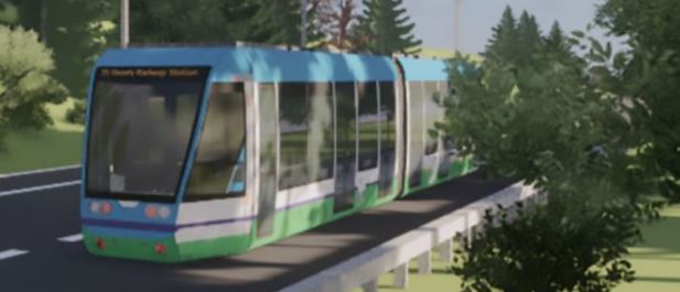
It could be a version of Van Hool’s ExquiCity BRT tram-bus, which is used is Belfast, Geneva, Metz and Parma – To name just four!
A hydrogen-powered version has also recently been introduced in Pau in France.
Could this be the version, that will be preferred for Cambridge?
- It would be carbon and pollution free.
- It could use exclusively green hydrogen, created from renewable electricity. Pau uses a hydrogen-generation system from ITM Power.
- Would hydrogen-power encourage passengers to use the system?
- It might borrow ideas from the Glider system in Belfast, which is diesel-electric powered.
- Each Belfast Glider vehicle can hold 105 passengers.
A hydrogen-powered system would surely be ideal for working in the tunnels under Cambridge.
Tunnels
This article on the BBC is entitled Cambridge Metro: Engineer Says Underground Will Work.
In the article, Professor John Miles of Cambridge University says.
Britain was a world leader in boring small tunnels
It will be tight in the cramped city, but it should be possible.
Conclusion
Oxford will want one!
‘Compelling Case’ Put Forward For £4bn Metro Network For Cambridgeshire
The title of this post is the same as that of this article on Rail Technology Magazine.
This is the first two paragraphs.
There is a “compelling case” for a metro scheme for Greater Cambridge after a feasibility report has claimed it could create 100,000 jobs and 60,000 new homes, but could cost £4bn.
The feasibility study was commissioned by the Cambridgeshire and Peterborough Combined Authority (CPCA), and mayor James Palmer declared there was a compelling case for the new regional transport network covering 88 miles.
Other details of the Cambridge Autonomous Metro include.
- Turn-Up-and-Go service.
- It would use trackless electric vehicles.
- Across Cambridge in twelve minutes.
- 7.5 miles of underground corridors under the City.
- Cambourne, Haverhill, Huntingdon, Mildenhall, St. Ives, St. Neots and Waterbeach would be served.
I think that the route network is feasible and if any City in England can fund such a scheme it is Cambridge.
I can see the point about trackless electric vehicles, as illustrated by this picture.
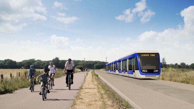
It looks to me, that the track is just a road with a cycle track alongside.
But would it be better to use tram-trains and the Karlsruhe model?
- This would enable the system to use the heavy rail tracks to Bury St. Edmunds, Ely, March, Newmarket and Wisbech.
- Bury St. Edmunds certainly needs a frequent service to Cambridge.
- East West Rail Consortium has a plan for a Parkway station on the A14, which needs a frequent connection to Cambridge.
- The technology is proven.
Hopefully, tram-trains have been rejected for good reasons.
But does the proposed system fit well with the East-West Rail Link.
