Before Crossrail 2 – A Narrow Four Track Station
As I said in my post on Brimsdown station, squeezing a four track railway through the station could be challenging.
But space can be saved, by not having any platforms on the fast lines, as in normal operation they will not be needed.
So would this be acceptable to the Health and Safety Authorities?
There is one station I use regularly, where two fast tacks run within ten metres or so of the slow platforms that I use.
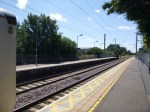
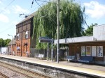
That station is Shadwell station on the Docklands Light Railway, where the c2c lines into Fenchurch Street are on the other side of the viaduct. This Google Map shows the layout of tracks through the station.

Shadwell Station
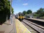
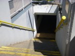
I would also borrow the idea from the DLR of putting a single platform between the two slow lines.
At Shadwell too, there is no bridge, but a series of steps lead up and down to the single platform. To make the station step-free there is a single lift at the end of the platform.
Surprisingly, in 2010-11, Shadwell had ten times the passengers of Brimsdom.
So perhaps you’d put a wide subway under the tracks, with perhaps a height of two metres or whatever is normal and then connect it to the single platform using steps, escalators and just a single lift. A similar layout to this is also used at Burnham station on Crossrail.
This station design has several advantages
1. The subway could be used by those not using the train, as they went about their business.
2. Passenger gates, waiting rooms,toilets, kiosks and staff could be stationed where they are needed – On the platform!
3. No fast trains would pass platforms with people on them.
4. Only a few trains not stopping in the station would come alongside the platforms.
5. Width can be designed in where it is important for safety and operational needs. So the single platform would not be narrow and an adequate gap could be left to the fast lines.
6. A safety barrier could be used to separate the fast lines from the slow lines and the platform to cut the opportunities for suicide.
At Burnham they do get problems with the layout, when the relief (slow) lines are not working. Wikipedia says this.
Unusually for a station on the Great Western Main Line, Burnham was built with platforms that serve only the relief lines, which makes it vulnerable to losing services when engineering work closes the relief lines and leaves trains only on the main lines. Consequently the station is frequently served by a replacement bus service at night.
I suspect though that this wouldn’t be so much of a problem along the Lea Valley as there are alternative lines, which seem are connected by buses.
Before Crossrail 2 – Brimsdown
I have a bit of a love hate relationship with Brimsdown station, despite having rarely used it as a start or end point of a train journey. It’s just that I’ve spent many minutes waiting for trains to cross the level crossing, in a car or with my bike. When I worked at Enfield Rolling Mills, I seemed that every other day, I had to wait perhaps ten minutes for a train to pass.
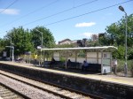

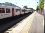
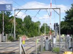

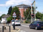
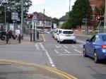
As you can see on a relatively quiet Sunday morning, the level crossing inconvenienced quite a few.
This Google Map shows the layout of the station and the roads around it.
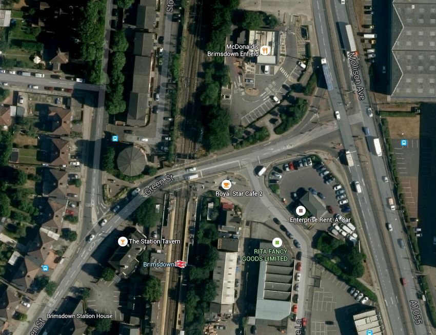
Brimsdown Station
This is going to be one station, where four-tracking and removal of the level crossing will not be easy.
I think that the four tracks could be squeezed through as there is green space on each side of the tracks, but there is so little space around the station that a bridge or an underpass for traffic would be impossible.
So I suspect the only thing to do is create alternative pedestrian and bicycle routes from one side to the other and close the level crossing.
It will not be popular!
Before Crossrail 2 – Meridian Water
Meridian Water is a large property development in North London which sits in the curve of the North Circular Road between Edmonton and Walthamstow, with the large Tesco and IKEA stores on its Southern boundary and the Edmonton incinerator to the North. Wikipedia describes the current site like this.
The Meridian Water development site is centred 1.2 km south east of the town centre of Edmonton Green. It comprises an area of approximately 0.82 km², 0.72 km² of which is land capable of development.
In economic geography the site consists largely of vacant or ailing industrial/transport use, and in natural geography is characterised by the waterways of the mid-Lea which pass through or beside it to the east: theRiver Lee Navigation, the Lee Diversion, the River Lee Flood Relief Channel, and Pymmes and Salmons Brook.
It is very much a part of North London, that is not doing its best to boost the prosperity of the city. The developers have a £1.5billion plan for the development of the site. This Google Map shows the area.
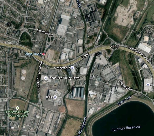
Meridian Water
Most of the site is between the North Circular Road and the various rivers and canals, although a portion is on the north side of the A406. This aerial photograph with the development marked in red comes from this page on the Enfield Council web site.
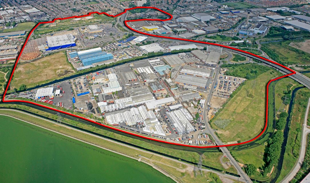
Aerial View Of Meridian Water
What has this massive development got to do with Crossrail 2?
Note the loop in the red boundary to the top of the picture. That encloses Angel Road station, which is clearly shown on the Google Map.
Meridian Water needs good transport links and this report in the Enfield Independent describes what Enfield Council and the developers are doing about it.
Enfield Borough Council has named the firm it has chosen to turn Angel Road Rail Station into a ‘thriving’ new hub.
Atkins, a global design and engineering firm, has been chosen to design the new rail and bus terminal, which will see an increased service of four trains per hour.
It is also stated in some place that the station will be renamed Meridian Water.
As Angel Road is on the list of probable Crossrail 2 stations in the Lea Valley, only a stupid developer would not want to have their development directly linked to Crossrail 2 and all the cornucopia of destinations it brings.
I also wonder how much the developers would pay to have the upgraded Meridian Water station, as a terminus, from where trains could turn back under London.
