A Passing Loop At Ponders End
I can’t write Ponders End without smiling, as my mother was born in that district of Enfield and used to refer to herself in light-hearted moments as a Ponders Plonker.
The West Anglia Main Line, through Ponders End station is a busy line and Enfield Council want to have four trains per hour (tph) serving their new development at Meridian Water.
This page on the CPMS Group web site is entitled The Changing Face Of Rail Investment and it describes the solution to the capacity problem at Ponders End/Meridian Water stations.
This is the introductory paragraph.
Peter George, Meridian Water Programme Director, London Borough of Enfield, and Damien Gent, Managing Director, CPMS Infrastructure, talk about the ground-breaking work undertaken by the London Borough of Enfield to deliver the rail infrastructure needed to increase passenger capacity at the newly built Meridian Water rail station and regenerate brownfield land to make space for up to 13,000 new homes and create over 6,000 new jobs in North-East London.
The Meridian Water project has been split into three phases.
- Phase 1 of the project was the construction of the new Meridian Water rail station.
- Phase 2 was building the rail infrastructure which would support the increased rail traffic.
- Phase 3 was the regeneration of the area, the procurement of new homes and creation of new jobs.
Only Phase 1 has so far been completed with Meridian Water station opening in June 2019.
This paragraph describes the complexity and solution to Phase 2.
The complexity of Phase 2 of the project was very high. The West Anglia mainline is one of the most congested routes into London. Consequently, the team had to find a way to reconcile increased capacity and trains stopping at Meridian Water station with ensuring high speed trains could still pass through the station seamlessly. This was a very challenging task. The solution which received the most support and proved the most viable was to install a new passing loop, approximately 1700 metres of new track at Ponders end, and to create a bi-directional section on the mainline heading towards London, as well as to implement broad changes to the signalling, telecoms and Overhead Line power systems to align with the new track position. This infrastructure solution provides the capacity within the rail network to then consider the timetable changes required to increase the frequency of services calling at Meridian Water.
It does seem that the web page is getting a bit ahead of reality.
But there is also this article on the Enfield Dispatch, which is entitled Boost For Rail Services At Meridian Water.
This is said.
Plans to boost rail services at Enfield Council’s £6billion Meridian Water regeneration scheme have taken a step forward.
The council has agreed a construction deal to create a passing loop at Ponders End Station, which will allow four trains per hour to serve Meridian Water Station, which was opened in June 2019.
The loop will enable fast trains on the West Anglia Main Line to overtake stopping services at Ponders End Station, allowing more trains to stop at Meridian Water, which is presently only served by two trains per hour towards Stratford.
To secure funding the works need to be completed by the end of March 2024.
A Visit To Ponders End Station
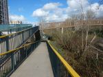
I went to Ponders End station this morning.
This Google Map shows the station.
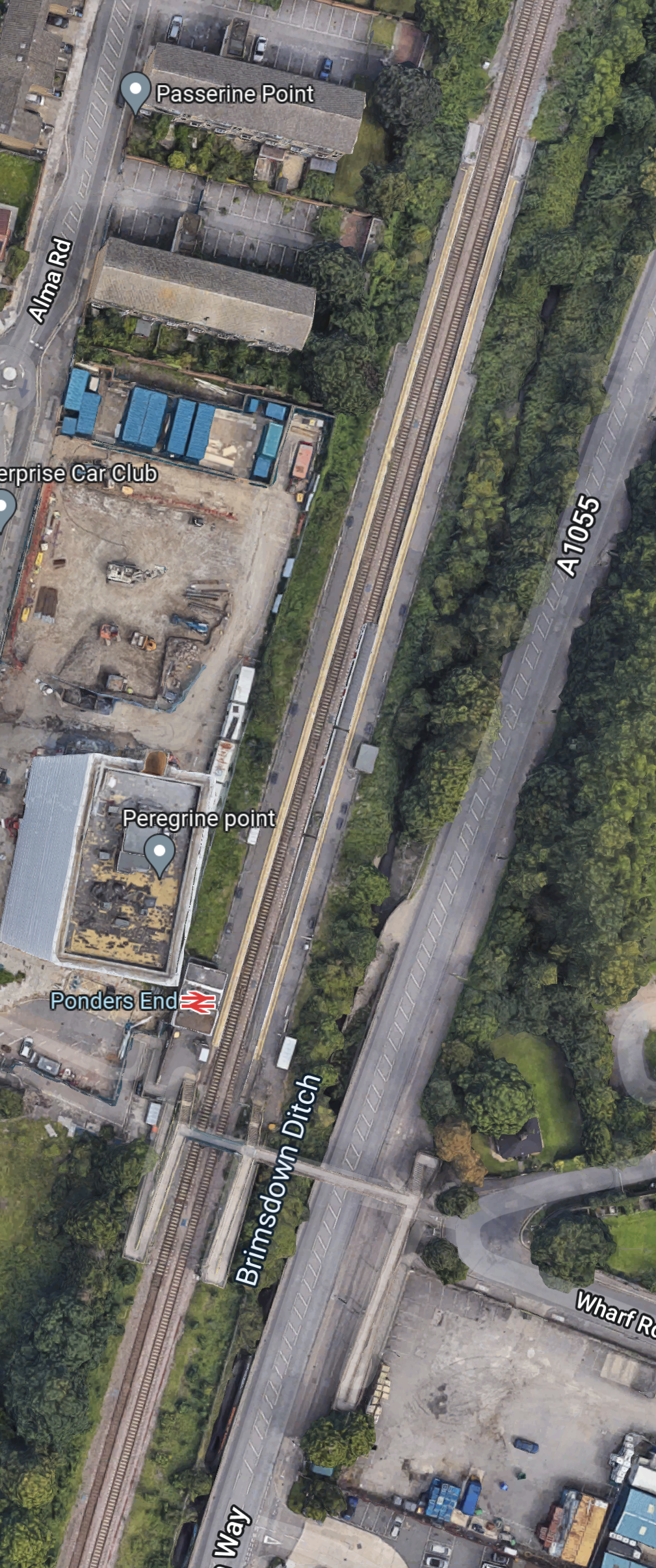
Note.
- The Brimsdown Ditch on the East side of the station.
- The footbridge spanning both the railway and the road.
- The footbridge has ramps for step-free access.
- I suspect that the platforms will take a 240 metre train.
These pictures show the station
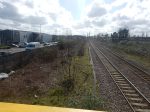
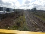
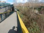

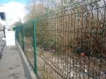

Note.
- The station serves the Lee Valley Regional Park and the Lea Valley Athletics Centre, so it probably needs lifts in an ideal world.
- The bridge seems to be built high enough for a track or even two to pass underneath.
- There seems to be plenty of space between the railway tracks and the A1055 road.
I wonder if a very simple solution is going to be built.
Consider that the distance between the two stations either side of Ponders End station is 3.2 miles or 5150 metres. So if the loop is placed symmetrically around Ponders End station to the East of the station, that would mean that the loop started and finished around 1700 metres from Brimsdown and Meridian Water stations. The Brimsdown Ditch could be put in a culvert, if more space were needed.
A Southbound express after passing through Brimsdown station would then take the loop between the platform and the road at Ponders End station and then cross over to the main line after the station.
I could envisage the Southbound express path through the three stations, being as straight as possible for several hundred metres through Ponders End station, with very gentle curves to connect to the current Southbound track at each end.
To access the Southbound platform at Ponders End, there would be two crossovers from the loop to the track through the station at each end of the station. As the train would be stopping or accelerating away, when it crossed between the passing loop and the station track, it could be done at a much slower speed.
There will be no problem for Southbound represses overtaking a stopping train sitting in Ponders End station. The loop would be very simple and I suspect Network Rail have enough expertise to design it for perhaps 100 mph. The sharpest changes of direction would only be performed by the stopping train at a much slower speed.
But surely, a Northbound train will need to overtake a stopping one.
Could this be done at Meridian Water station by stopping the Northbound stopping train in Platform 3 at the station and allowing the Northbound expresses to overtake through Platform 4?
It would need a couple of crossovers either side of Meridian Water station and bi-directional running through Platform 3 at the station.
Conclusion
How many small rail schemes like this, that unlock housing and job opportunities could be accelerated by better design, management, planning and cooperation between stakeholders.
Vital Energi To Build Waste Heat From Power Plant Centre
The title of this post, is the same as that of this article on the Construction Enquirer.
This is the introductory paragraph.
Waste heat from the nearby £680m North London Waste Authority (NLWA) Energy Recovery Facility will be used to heat homes and businesses in the London Borough of Enfield.
Some of the homes, will be on the 82-hectare Meridian Water development.
We will see more schemes like this.
Major District Heating Scheme to Connect £6bn Meridian Water Development
The title of this post is the same as a press release from Vital Energi.
This is the first three paragraphs.
London’s latest £85m district heating infrastructure is taking shape in Enfield and will be delivered by Vital Energi on behalf of energetik, the energy company owned by Enfield Council.
The new district heating network will accommodate up to 30,000 homes and businesses, including the £6bn Meridian Water development. energetik want to revolutionise the local energy market and improve the reputation of district heating, in a currently unregulated market, to ensure customers receive a quality service.
Vital Energi will design, build, operate and maintain the main energy centre for Meridian Water and install the district heating network over the next 12 years, under a contract worth £15m. This heat network is part of an integrated energy and regeneration strategy in Enfield that will interconnect with energetik’s other networks at Arnos Grove and Ponders End.
The Meridian Water development is certainly going about things in an impressive way.
West Anglia Route Improvement – Enfield Council And Rail Companies
This article in the Barnet and Whetstone Press is entitled Transport Blow To Meridian Water Development.
This is said.
THE council has admitted spending nearly £200,000 on an unsuccessful judicial review into a transport decision that could drastically undermine its vision for the multi-million pound Meridian Water housing development.
In September last year, the Department for Transport told rail companies thinking of bidding for the franchise through Angel Road railway station, in Edmonton, that a successful bid would not have to guarantee a minimum of four trains an hour.
You don’t call for a judicial review lightly and as Enfield lost, I suspect they were none to pleased with the Department of Transport and the various rail companies.
I then found this article on 21st Century Rail, whih is entitled Network Rail needs to get a grip of GRIP.
This is how the article starts.
Network Rail’s infrastructure upgrade process has been severely criticised by one of Enfield Borough’s leading planners.
The Meridian Water project is part of the borough’s wider regeneration plan for the Lea Valley area, which involves re-siting and constructing a new Angel Road station – to be renamed Meridian Water – and installing a third track between there and Stratford.
It then contains a fairly savage attack on Network Rail’s planning process.
The article does include this about plans for the Stratford – Angel Road train service.
It is part of Network Rail’s wider STAR project (Stratford-Tottenham-Angel Road) to increase capacity on WAML (the West Anglia mainline). The third track will run for about five miles; Network Rail is working with the DfT to increase the number of trains to four per hour (tph). Between 2019 and 2024, WAML will be widened to take four tracks and the capacity increased to handle 8tph. If Crossrail 2 is built, capacity will be doubled again to 16tph by 2030.
But it does seem that relations between Enfield Council and Network Rail and the other rail companies could be better.
West Anglia Route Improvement – Meridian Water, Road Traffic And Level Crossings – 1st March 2017
This map from the Meridian Water web site shows the area of Meridian Water outlined in red.
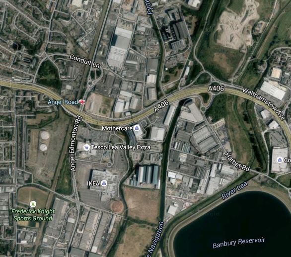
And this Google Map shows the Lea Valley from the North Circular Road in the North almost to Tottenhsm Hale in the South.
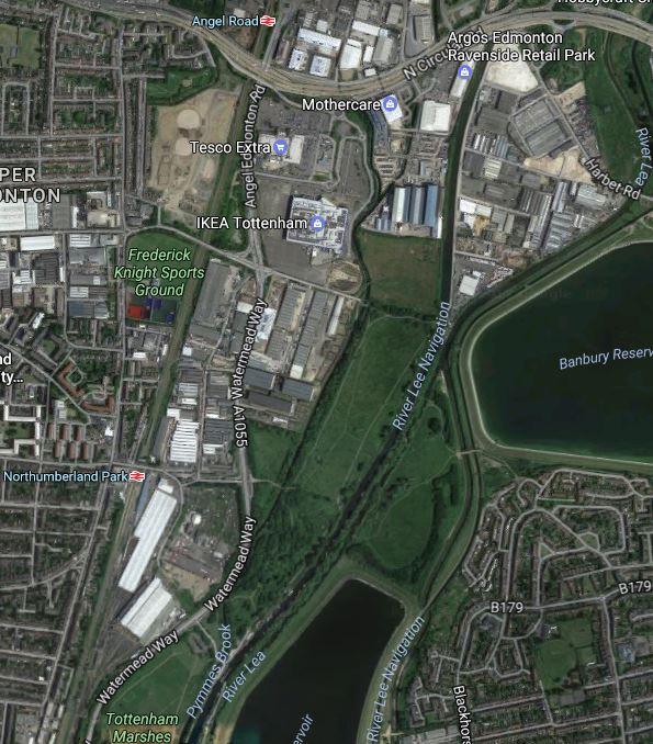
Note.
- Tesco and IKEA are in the middle of the Meridian Water site with the West Anglia Main Line and the main North South road to their West.
- The River Lea and the River Lea Navigation Canal pass between the Meridian Water site and the Banbury Reservoir.
With the building of Meridian Water, traffic in the area is only going to get worse.
The main North-South route shown in the second map starts North of Enfield Lock, where it has rather dodgy connections to the M25 and is generally a single carriageway road, all the way to the Tottenham Hale Gyratory, where traffic is heavy at all times.
One problem is going or coming West from this North-South route, as vehicles need to cross the West Anglia Main Line.
Starting from the North, the crossings of the railway are as follows.
- A level crossing at Enfield Lock station.
- A level crossing at Brimsdown station.
- A bridge for the A110
- A bridge at Conduit Lane, just North of the current Angel Road station.
- The North Circular Road, which is not well-connected to the North-South route.
- A bridge at Leeside Road, just South of the proposed site of Meridian Water station.
- A level crossing at Northumberland Park station.
Another bridge over the railway delivers you into the jams at Topttenham Hale.
STAR is currently envisaged to provide a seven-day-a-week services of four trains per hour (tph) between Angel Road and Stratford with calls at Northumberland Park, Tottenham Hale and Lea Bridge stations.
However the current local service up the Lea Valley from Stratford goes to Hertford East and Bishops Stortford stations with a rather erratic stopping pattern at stations North of Tottenham Hale.
So will STAR be based on these services or a separate train turning back at Meridian Water station?
But whatever happens it will increase the number of trains through Northumberland Park station.

It has now been announced in the last few weeks, that the level crossing will be closed.
Drivers wanting to go across the level crossing, following the closure will now do one of the following.
- Go South and over the railway to Tottenham Hale.
- Go North and cross the railway on the Leeside Road bridge.
They could always use the train.
I think the following would help mitigate the loss of the crossing.
- Some road improvement at the junction of Leeside Road and the North-South road.
- A decent pedestrian route between the new Meridian Water station and Glover Drive for Tesco and IKEA.
- The STAR service going North from Meridian Water station, as well as South to Stratford.
Hopefully, it will all be clear by the end of 2018.
Meridian Water Gets Its First Planning Permission
This article in the Enfield Independent is entitled Planning permission given to first batch of Meridian Water homes. This is the start of the article.
Work will soon start on the first homes in a £3.5billion development after getting the planning green light.
Enfield Council’s planning committee has given permission for the first phase of Meridian Water, agreeing to the construction of 725 homes, as well as retail space, play areas, a community centre and a new train station which will have the facilities to include the planned Crossrail 2.
The decision follows the announcement last month of Barratt and SEGRO as developers for the scheme, which the council hope will provide 10,000 homes and 6,700 jobs in Edmonton.
London certainly needs this development with all its houses and a replacement for Angel Road station and I doubt that few will mourn the passing of the industrial wasteland that the area is now.
Could The Gospel Oak to Barking Line Transform East London?
Two reports on the web prompted me to write this post.
The first was an article on CityMetric entitled Forget Road Bridges. TfL Should Extend The Overground To Thamesmead And Abbey Wood, which prompted me to write No To Silvertown Tunnel.
The second report was on various web sites with headlines like Enfield Council Shortlists Developers For Meridian Water.
Enfield Council is planning to build substantial numbers of new homes at a 85 ha site called Meridian Water near Lee Valley Regional Park over the next couple of dcades.
To help the development at Meridian Water, the station at Angel Road is to be improved and this page on the Meridian Water web site gives details. This extract details the development of the station and the related rail line and transport interchange.
The station will be a thriving new hub that combines rail and bus services to provide better access to Meridian Water for future residents and businesses. Meridian Water is a new £1.5 billion, 85 hectare, eco-development which will provide up to 5,000 new homes and up to 3,000 new jobs. The improvements, which will be completed in the next five years, will bring benefits for those that currently live and work in the area, as well as the new residents of the Meridian Water development. The project is being funded with £2.5 million from the Greater London Authority with a further £1 million from Enfield Council. This new station combined with additional investment in three tracking the railway, will bring forth a four trains per hour service at Angel Road Station.
All good stuff and very much about motherhood and apple pie in the manner of the way that the Metropolitan Railway used to sell Metroland.
But let’s not knock it for that, as London needs lots of new housing and the current station, Angel Road, which will be renamed Meridian Water, is one of the worst transport interchanges in the UK,. They’ve probably got better stations in many of the worst slums in The Third World.
Angel Road is just two platforms and a bridge as Before Crossrail 2 – Angel Road shows, whereas the average station in deepest Africa or South America, probably has at least someone, who’ll help you or sell you a tasty local morsel or a bottle of fizzy drink.
Whilst looking at developments in this area, it is worth looking at the wider area and investigate how transport links might develop. This Google Map shows the Lower Lea Valley from Angel Road and Meridian Water in the North to Lea Bridge Road in the South.
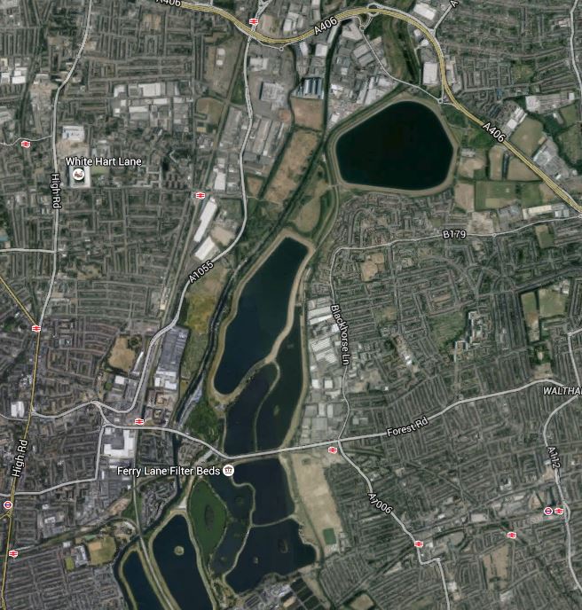
Lower Lea Valley
In addition to the housing developments at Meridian Water, more housing is being developed around Tottenham Hale station and other places in the area. But the development that will have the biggest impact on the area is not these developments but Thames Water and Waltham Forest’s massive plan to create the Walthamstow Wetlands. The project web site has this strap-line.
Transforming Walthamstow Reservoirs into a new urban wetland reserve for London
I have written about the Walthamstow Wetlands before in Before Crossrail 2 – Walthamstow Wetlands and now the project has its own web-site, I shall be following this exciting project a lot more. I believe the project has a lot going for it, but also it could be very important for Thames Water, who over the last few years haven’t exactly had the best of publicity at all times, what with our water bills and the Thames Tideway Scheme.
Because so much of London’s water is stored in the Lea Valley, it is very much in their interest to be good neighbours to the people and wildlife of the area.
The map also shows the rail links through the area.
1. The Lea Valley Lines
The Lea Valley Lines go northwards from Liverpool Street, Stratford and Hackney going up to Broxbourne, Hertford, Cambridge and Stansted Airport and as indicated earlier, extra tracks are being added and stations like Angel Road are being upgraded. A new station at Lea Bridge is also being built.
2. The Victoria Line
The Victoria Line goes underneath the area and links Central London to Tottenham Hale and Walthamstow. The line was built on the cheap in the 1960s and I have dreamed of what might have been. This August the line is closed to rectify one of its shortcomings, which will increase the capacity of the line.
3. The Chingford Branch Line
The Chingford Branch line crosses the Lea Valley Lines and the Walthamstow Wetlands as it links Chingford to Hackney and Liverpool Street. It is a line that can’t be extended, but there are plans to link it to the Lea Valley Lines by reinstating the Hall Farm Curve to allow trains to run from Stratford and Lea Bridge to Walthamstow and Chingford.
4. The Gospel Oak to Barking Line
The Gospel Oak to Barking Line (GOBlin) is the forgotten and down-trodden Cinderella, who could gatecrash the party in the Lea Valley and be a star of East London’s transport system.
Over the next few years, the following will or may happen to the line.
- Electrification
- Extension to Barking Riverside
- New four-car electric trains
- Smaller numbers of day-time freight trains.
- Increased passenger train frequency
The first three are hopefully cast in stone, as to cancel them now, would probably cost more than doing them. Especially, as the new trains have been ordered.
I am hopeful, that once the line is upgraded and electrified, this will enable freight operators to switch to electric traction, that could mean quieter services that might possibly run through at night.
As an aside, if I was standing for London Mayor, I would say I would put a limit of perhaps two non-electric trains a day on both the GOBlin and the North London Line. The freight operators would protest, but Class 66 locomotives have no business going through residential areas and crowded stations. Especially, when environmentally acceptable locomotives are available.
If the number of day-time freight trains could be reduced, this would allow more passenger services.
5. Crossrail 2
Crossrail 2 will have a big impact, when and if it arrives, as it will serve Tottenham Hale, Northumberland Park and Angel Road.
Before I finish this post, I have to ask, if we are doing enough with our transport network to serve large developments like Meridian Water, the Walthamstow Wetlands and Barking Riverside.
So what would I look at?
1. Crossrail 2
Politicians of all colours and tendencies are putting their faith in Crossrail 2.
But, I believe that the line, although surveys show it is much-needed, is a bit like the US Cavalry in a 1950s film, arriving in force after the poor settlers or ranchers have virtually been wiped out by the Indians.
We should prepare for Crossrail 2, so that all the engineering and architectural connections are there and all surface stations are upgraded over the next few years. This would mean that building Crossrail 2 would be just a matter of accurately threading the needles and then linking the tunnels to the existing stations.
Perhaps we should think of Crossrail 2 as a series of closely-related projects, rather than one huge mega-project.
- The main tunnels from Walthamstow Marshes to Wimbledon.
- The rebuilding of Central London stations to make them Crossrail 2-ready. Tottenham Court Road is already awaiting the tunnellers.
- The upgrading and rebuilding of the surface stations and rail infrastructure.
The great advantage of this, is that political responsibility for a lot of the work like the upgrading of surface stations, can be shared with the relevant Local Authority.
This post started with Enfield Borough Council and the Meridian Waters project and wandered into rail infrastructure, because Angel Road station is an important part of that project.
I doubt I’ll ever live long enough to see the opening of Crossrail 2. But I live in hope!
2. Improving Connectivity On The Gospel Oak to Barking Line
The Gospel Oak to Barking Line hasn’t got the best connectivity to other lines and it is also blessed with some difficult out of station interchanges for even strong walkers.
Walthamstow is an example, where the walk between Queen’s Road and Central isn’t that long but it is tortuous. This Google Map shows the area.
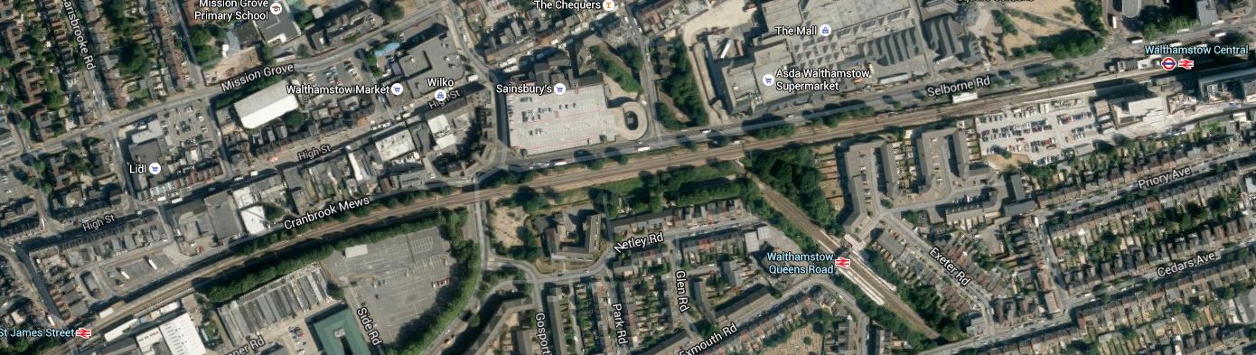
Walthamstow Stations
The East-West line is the Chingford Branch, with St. James Street station in the West and Central in the East. Croosing this line is the GOBlin with its station at Queen’s Road.
Surely something better could be done in Walthamstow. Interchange for someone pushing themselves in a wheelchair would be very difficult.
There is also an out of station interchange between Wansted Park on the GOBlin and Forest Gate on the lines out of Liverpool Street, which in a few years time will be Crossrail. This map shows the area.

Wanstead Park And Forest Gate
It is an area, where some selected development could be of value, especially as the GOBlin passes over the Liverpool Street Lines. I’ve walked this interchange a couple of times and the following would help.
- Step-free access at both stations. Forest Gate is getting this with Crossrail.
- A light-controlled crossing at Wansted Park station
- A minor rerouting of the buses so that some passing through the area stop at both stations.
This would mean that someone pushing themselves in a wheelchair could use the interchange.
One station that needs to be improved is Blackhorse Road, which connects the GOBlin to directly to the Victoria Line. This Google Map shows the area.
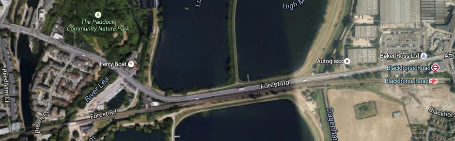
Blackhorse Road Stations
Note that the station site is not particularly cramped and it would be a not-to-difficult walk to the Walthamstow Wetlands, especially if you could hop on a bus for a couple of stops.
There is also the possibility of an improved station at Harringay Green Lanes, where a large amount of property development is possible according to this document on the Harringey Council web site. I talked about the possibilities in The Piccadilly And Victoria Lines, Manor House Station And Harringay Green Lanes Station, where I believe a flagship station could be built across Green Lanes.
This section in the Wikipedia entry for the GOBlin, lists other ideas for extra connectivity for the line.
But I believe there are three other important interchanges that will or may happen and I describe them in the next three sections.
3. Seven Sisters Interchange With Gospel Oak to Barking Line
Transport for London’s Plan for 2050, has a section in an Appendix with the heading of News links and/or Stations for Strategic Interchange. In a list of places where this might be done are the words Seven Sisters (GOB). Seven Sisters station is currently a valid out of station interchange with South Tottenham station on the Gospel Oak to Barking Line. In Crossrail 2 At South Tottenham/Sevens Sisters, I speculated as to how the two stations could be linked by a large double-ended Crossrail 2 station. This Google Map shows the two stations.
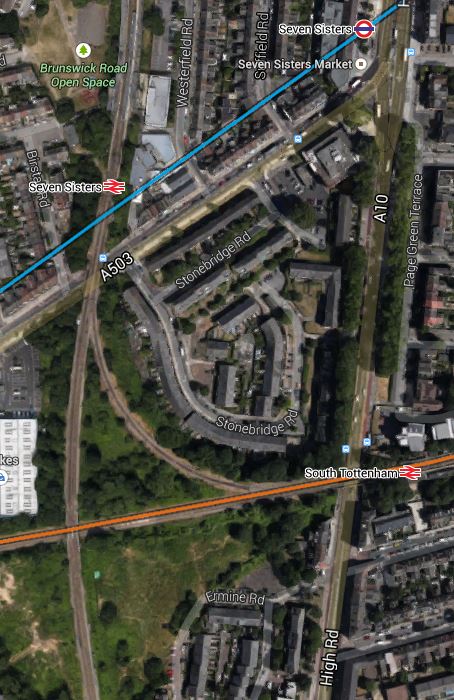
South Tottenham And Seven Sisters
There are also other possibilities here, like building a new station, housing or commercial development or allowing trains to link from the Northbound Lea Valley Lines through Seven Sisters to the Eastbound GOBlin. But whatever happens here, the GOBlin will eventually be linked to the Victoria Line and Crossrail 2.
Search the Internet and You’ll find little about this project, which is just two words buried in a TfL report.
4. Extending The GOBlin To Angel Road
This is speculation on my part, but the Meridian Water development will need more than just the one station at Angel Road. As the GOBlin goes across the southern part of the development site, is there an opportunity for an innovative connection through the development to Angel Road? This is a Google Map of the area from Angel Road in the North to Blackhorse Road in the East.
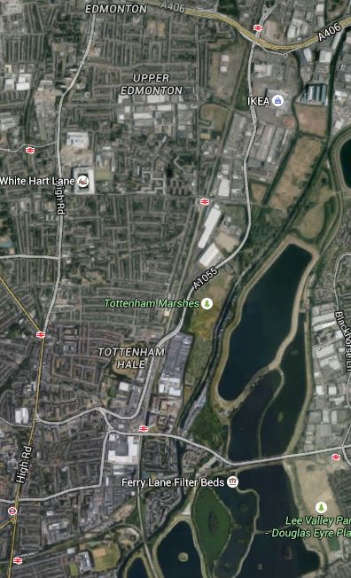
Blackhorse Road To Angel Road
The connection might be difficult for a train, but use a Class 399 tram-train and it could twist and turn its way between Blackhorse Road and Angel Road stations amongst the reservoirs and the developments to serve both those developments and the Walthamstow Wetlands.
5. Extending The GOBlin To Thamesmead And Abbey Wood
In No To Silvertown Tunnel, I examined the possibilities of extending the GOBlin from Barking Riverside over or under the Thames to Thamesmead and Abbey Wood station, where it would join up with Crossrail.
I felt that this would best be done using Class 299 tram-trains as they could go walk-about on both sides of the river giving much needed connectivity to the housing on both sides of the river. If it could be done, I felt that a bridge shared with pedestrians and cyclists would be the best way to join the two banks of the Thames.
6. The Hall Farm Curve, High Meads Loop and Dalston Eastern Curve
These three curves, if reinstated for passenger trains would create routes between the Chingford Branch and Lea Bridge, Stratford and any desirable station to the West. Reopening the Dalston Eastern Curve would give access to the East London Line for Crossrail at Whitechapel and South of the Thames.
As there could be spare capacity on the East London Line, which has been designed for twenty-four trains per hour, there could be a myriad of ways it can be used to increase the services under the Thames, so what Transport for London might do would be pure speculation on my part.
But I think they will eventually use these three curves to improve services in the Lea Valley.
7. Tram-Trains On The GOBlin
This may seem a bizarre idea, but having seen these hybrid vehicles all over Germany, I believe tram-trains are the way to add extra destinations to core electrified lines. On the Gospel Oak to Barking Line, in addition to being used to connect to Angel Road, as I showed previously, they could also be used with a tunnel or a bridge to extend the line from Barking Riverside under or over the river to Thamesmead and Abbey Wood.
People might worry that when running as trains, they may need different stations to the other trains, but the Germans seem to be able to design stations that accept both vehicles and I suspect the planned Rotherham extension of the Sheffield Supertram, will come up with solutions applicable to our standards. As to the required overhead lines, the Class 399 tram-trains can run using any of the voltages used for trams and trains in the UK.
There may be other places on the GOBlin and the other rail lines in East London, where tram-trains could be used effectively.
This will obviously be up to the planners, but I will be very surprised if tram-trains don’t infiltrate there way into many places all over the UK. At the moment transport planners, haven’t the experience of seeing a well-designed tram-train system working in the UK, but after what I believe will be a successful trial in Rotherham, I think we’ll see planners embracing the technology with open arms.
Conclusion
The GOBlin won’t be Cinderella any more!
Before Crossrail 2 – Walthamstow Wetlands
The Walthamstow Wetlands have nothing really to do with Crosrail 2, but like Meridian Water they will have connections and interactions with the railway.
So how will the wetlands interact with Crossrail 2?
This image, which I clipped from this page, shows the layout of the wetlands.
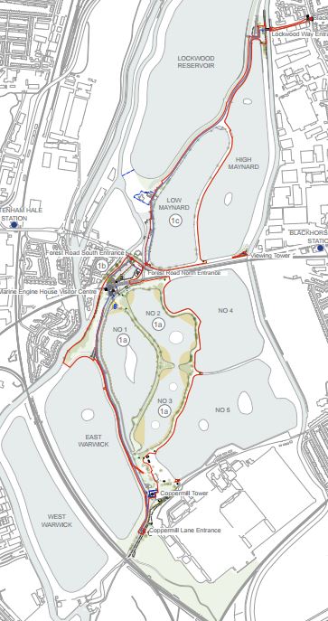
Map Of Walthamstow Wetlands
And this is a Google Map of the same area.
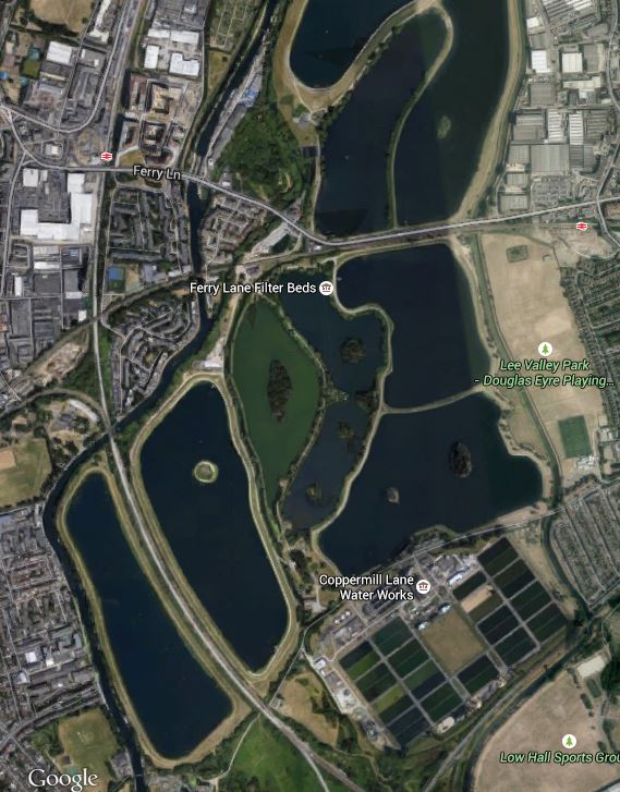
Google Map Of Walthamstow Wetlands
There are plans for entrances at Blackhorse Lane by Blackhorse Road station and at Coppermill Lane, just below the pair of Warwick reservoirs at the bottom left of the Google Map. The West Anglia Main Line runs between the reservoirs and Crossrail 2 will probably emerge from its tunnels between these reservoirs and Tottenham Hale station.
I also suspect that some means to get into the wetlands will be provided at Tottenham Hale station, That will probably be walking and bicycle routes,perhaps coupled with a shuttle bus. I do wonder whether the Gospel Oak to Barking Line, which borders the wetlands and passes just to the south of Tottenham Hale station might be brought into the mix. Nothing within the limits of sensible engineering should be ruled out.
After all Waltham Forest Council has obtained £4.4million from the Heritage Lottery Fund and that is a lot of reasons to think, that everybody wants the unique project of the Walthamstow Wetlands to be extremely successful.
Big projects work best from co-operation and not annoying the locals. Crossrail showed with the East-West line that they are masters at pulling it all together and used archaeology to get the locals enthused with the project, I suspect that they will use every opportunity to get the general public and politicians behind Crossrail 2.
I think that we will see Crossrail 2, Meridian Water and the Walthamstow Wetlands working together to develop the Lee Valley into London’s lung.
If
Before Crossrail 2 – Meridian Water
Meridian Water is a large property development in North London which sits in the curve of the North Circular Road between Edmonton and Walthamstow, with the large Tesco and IKEA stores on its Southern boundary and the Edmonton incinerator to the North. Wikipedia describes the current site like this.
The Meridian Water development site is centred 1.2 km south east of the town centre of Edmonton Green. It comprises an area of approximately 0.82 km², 0.72 km² of which is land capable of development.
In economic geography the site consists largely of vacant or ailing industrial/transport use, and in natural geography is characterised by the waterways of the mid-Lea which pass through or beside it to the east: theRiver Lee Navigation, the Lee Diversion, the River Lee Flood Relief Channel, and Pymmes and Salmons Brook.
It is very much a part of North London, that is not doing its best to boost the prosperity of the city. The developers have a £1.5billion plan for the development of the site. This Google Map shows the area.
Meridian Water
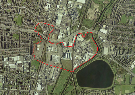
Most of the site is between the North Circular Road and the various rivers and canals, although a portion is on the north side of the A406. This aerial photograph with the development marked in red comes from this page on the Enfield Council web site.
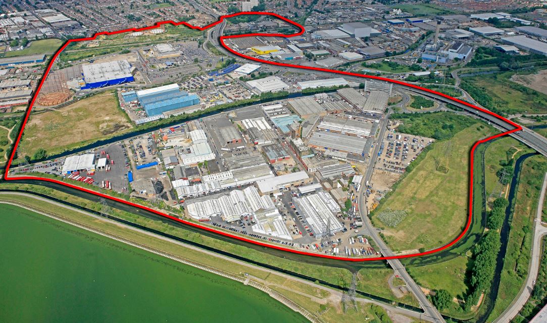
Aerial View Of Meridian Water
What has this massive development got to do with Crossrail 2?
Note the loop in the red boundary to the top of the picture. That encloses Angel Road station, which is clearly shown on the Google Map.
Meridian Water needs good transport links and this report in the Enfield Independent describes what Enfield Council and the developers are doing about it.
Enfield Borough Council has named the firm it has chosen to turn Angel Road Rail Station into a ‘thriving’ new hub.
Atkins, a global design and engineering firm, has been chosen to design the new rail and bus terminal, which will see an increased service of four trains per hour.
It is also stated in some place that the station will be renamed Meridian Water.
As Angel Road is on the list of probable Crossrail 2 stations in the Lea Valley, only a stupid developer would not want to have their development directly linked to Crossrail 2 and all the cornucopia of destinations it brings.
I also wonder how much the developers would pay to have the upgraded Meridian Water station, as a terminus, from where trains could turn back under London.
