Andy Burnham Promised 10,000 Council Houses. Guess The Tally So Far
The title of this post, is the same as that, of this article in The Times.
This is the sub-heading.
Greater Manchester is a success story but that has little to do with the mayor, still less the economic model he is touting for the country
These are the first two paragraphs.
I don’t like being mean to Andy Burnham. With his soft, doe-eyed features, it feels rather like punching a lamb. But it’s quite an achievement when “We’ve got to get beyond this thing of being in hock to the bond markets” isn’t actually the stupidest thing a politician has said in any given week.
The other day Burnham kicked off his not-quite-a-leadership bid by urging Labour to embrace “Manchesterism”. This he defined as “business-friendly socialism”, in which the state “rolled back the 1980s” by seizing control of “the basics of life”: housing, energy, water, rail. This included borrowing £40 billion for new council housing.
This paragraph from Robert Colville gives the current progress on housing in Manchester.
Burnham did announce, in May 2024, that he was going to build 10,000 council houses by 2028. But over the following year the region started construction on just ten. No, that’s not a typo.
That is not a good start!
TerraLithium, BHE Renewables Announce Key Milestones For Geothermal Lithium Project In California
The title of this post, is the same as that of this article on ThinkGeoEnergy.
This is the sub-heading.
TerraLithium and BHE Renewables have announced key milestones towards advancing technology for lithium extraction from geothermal brines in Imperial Valley, California.
This is the important paragraph in the article.
The business model of coupling lithium and critical minerals extraction with geothermal energy production is gaining increasing attention, both in the United States and in countries like Germany, France, and the UK. As demonstrated in the United Downs geothermal power project in Cornwall, lithium extraction provides additional revenue generation that can significantly improve the economics of deep geothermal projects.
So here we have little Cornwall showing Big California how to get power and lithium out of hot rocks.
In Cornish Plant Produces Geothermal Power, I described the progress at the Cornish plant in March.
Has Andy Burnham Ever Said Anything On Geothermal Energy?
Given that there is an election or coronation under way, I just had to ask Google AI, the question in the title of this section.
This is the answer I received.
Yes, Andy Burnham has occasionally engaged with topics involving geothermal energy, particularly in the context of tapping natural underground heat and mine water for green energy
His notable references to the technology include:
Supporting Manchester’s Geothermal Potential: He has voiced support for localized renewable heat projects, such as exploratory borehole plans in Manchester city centre intended to tap into thermal springs for community heating.
I think we can put that down as a favourable view.
This excellent article on the BBC is entitled Plan To Heat Manchester Homes With A Geothermal Spring, is worth a full read.
What Housing Is Being Built At Cockfosters Station?
I was looking for something to watch on the television and noticed that Cockfosters FC were in the FA Vase final today at Wembley against AFC Stonham.
For the first sixteen years or so of my life, I lived in Cockfosters, and until now, I never knew they had a football team, which is actually based just around the corner from the church, where I got married to C on September 7th 1968.
This Google Map shows the area.
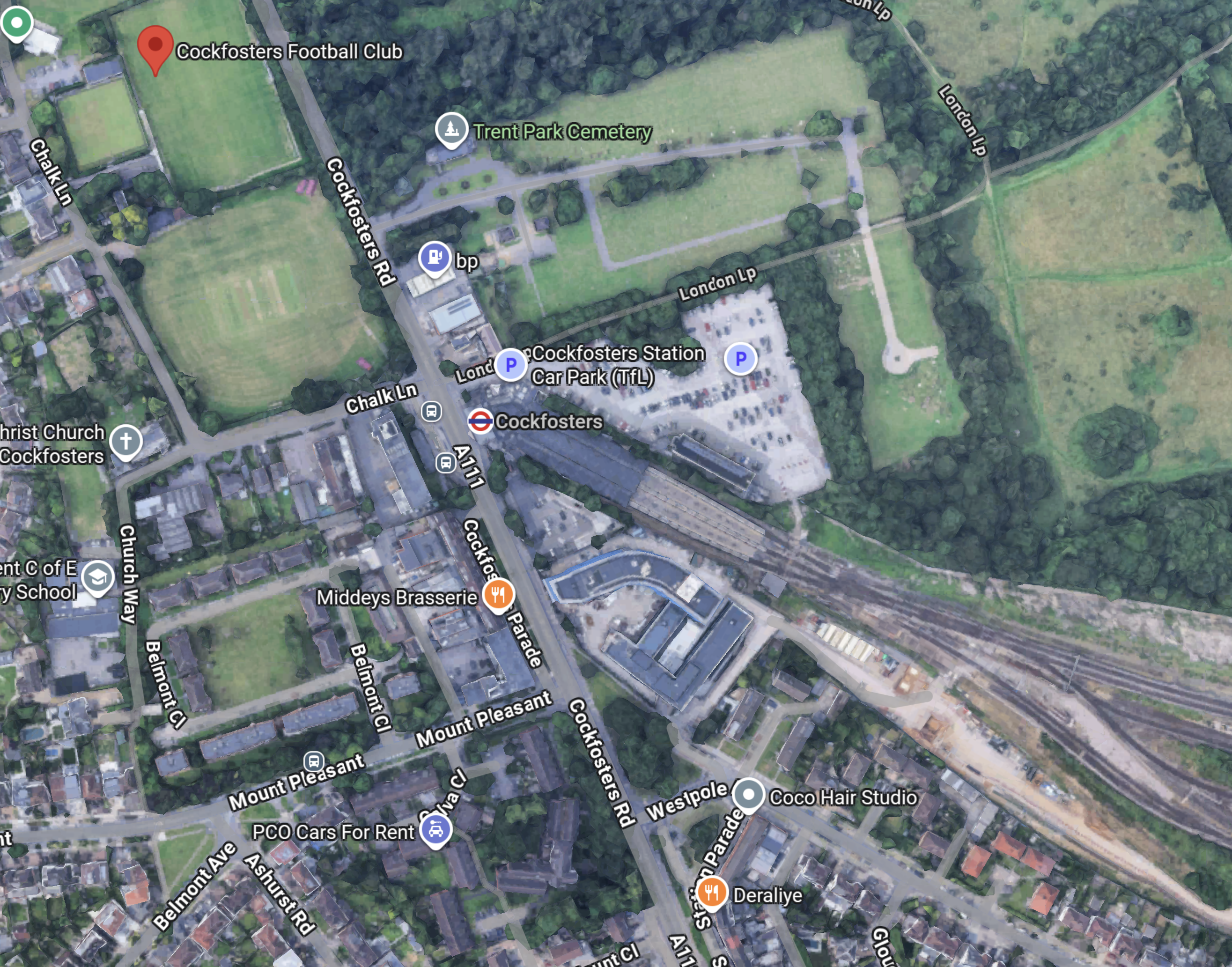
Note.
- The red arrow at the top of the map indicates Cockfosters F.C.
- Christ Church, Cockfosters is to the South of the football club.
- Cockfosters Road runs slightly diagonally down the map.
- Cockfosters station on the Piccadilly Line is indicated by the London Transport roundel.
- Cockfosters station has extensive car parking to the North-East of the station
- Cockfosters Depot is to the South-East of the station.
Our house was just off the Southern edge of the map, by Southgate School.
A 3D Image Of Cockfosters Station
This Google Map shows a 3D image of Cockfosters station and the buildings around it.

Note.
- Cockfosters station is indicated by the roundel.
- The station is a Grade II Listed building.
- The station has an elevation of 97 metres.
- Half of the station car park is going to be turned into housing.
- Trent Park lies to the North of the station.
- The road in front of the station is Cockfosters Road, which to the North joins the M25 at Junction 24.
- The building between Cockfosters Road and the railway used to be offices, but it is now being converted into starter housing.
In Starter Homes At Cockfosters, I write about starter homes being developed on the South side of the station.
Artificial Intelligence On The Housing In The Car Park
I asked Google AI the question in the title of this post and received this answer.
Places for London (Transport for London’s property arm) and Barratt London are building 373 residential apartments across four tower blocks on the former Cockfosters Station car park site. The largely car-free, mixed-use scheme includes 40% affordable housing, new public open spaces, and revamped TfL staff facilities.
Key Project Details
Total Homes: 373 apartments (a mix of 1, 2, and 3-bedroom properties).
Housing Tenure: All flats will be built for rent, with 40% of them allocated as “affordable” (including social rent and intermediate housing).
Building Heights: Four tower blocks ranging between 5 and 15 storeys tall.
Station Parking: The development is largely car-free.
Around 68 parking spaces will be retained at the station, including 12 dedicated Blue Badge spaces.
Public Amenities: The scheme introduces about 4,500 square meters of publicly accessible open space, children’s play areas, cycle storage, and minor commercial floor space.
Development Background
While planning permission for housing on the site was originally granted by Enfield Council in 2022, the project faced years of delays.
In late 2025 and early 2026, revised plans were submitted to add an extra storey to each building to accommodate updated fire safety legislation—adding 22 more homes to the initial 351 proposal.
You can track local planning updates and track progress via the Enfield Council Planning Portal.
I have some thoughts about this development.
Was There Any Opposition To Building Flats On Cockfosters Station Car Park?
From when I lived in the area, I remember that Cockfosters car park was well used in the 1960s and that trains on the Piccadilly Line were exceedingly busy, as I sometimes used to get them to travel to school.
I asked Google AI the question in the title of this section and received this answer.
Yes, there was intense opposition to the proposal to build flats on the Cockfosters Station car park.
The plans to build over 350 homes across blocks reaching up to 14 storeys faced major pushback from local residents, commuters, and Conservative MPs.
The primary points of contention included:
Loss of Parking: Opponents were concerned that wiping out hundreds of park-and-ride parking spaces would reduce the station’s accessibility.
It sparked fears that it would increase traffic on local roads and make journeys impossible for many, particularly blue-badge holders.
Over-development: The proposed height and density were heavily criticized for being out of character for the surrounding outer-suburb.
Heritage and Green Belt Impact: Residents argued that the massive tower blocks would negatively impact the neighboring Trent Park Conservation Area and the Charles Holden-designed Grade 2-listed station building.
Despite the controversy—which generated nearly 3,000 objections and was temporarily halted by the government in 2022—the project was officially given the green light to proceed. You can find full details on the planning outcomes via the Enfield Council Planning Portal or by reviewing the BBC News coverage of the development’s approval.
Do Any Train Depots Have Housing On Top?
I feel that we should maximise housing and in estates like the Barbican, there is extensive housing on top of car parking and even some active railways.
So why not on top of train depots like Cockfosters?
I asked Google AI the question in the title of this section and received this answer.
Yes, train depots and railyards increasingly feature housing built directly on top of them. Because large, open plots are scarce in dense cities, decking over active railway infrastructure has become an innovative engineering solution to generate new residential spaces.
Prominent examples of housing built over railway land include:
Royal Mint Gardens (London, UK): luxury residential and mixed-use development built directly above active train tracks on the approach to London Fenchurch Street.
Hudson Yards (New York, USA): The largest private real estate development in the U.S. features numerous residential skyscrapers built on a massive elevated platform constructed directly over the active John D. Carolan West Side Yard.
North Manhattan Rail Yards (New York, USA): Several multi-family residential projects, such as the Triangle Equities development over the MTA’s East 180th Street depot, utilize air rights to stack housing above active transit operations.
Hong Kong (Global Pioneer): Many of the city’s MTR depots (such as the Tseung Kwan O or Siu Ho Wan depots) and their surrounding stations have extensive private residential estates (known as Rail + Property Developments) built directly onto elevated decks atop the facility.
How is it done?
Building over a depot or railway requires constructing a heavy-duty “crash deck” or podium over the tracks. To prevent the noise, vibrations, and emissions of the trains from disturbing residents, developers use advanced building vibration isolation techniques. The residential buildings are structurally separated from the rail lines using specialized acoustic bearings and shock-absorbing foundations.
As we haven’t got the land in our big cities we should go for it.
Is The New London Museum Built Over Train Tracks?
This link shows all my posts on the new London Museum, as it will be called.
But what does Google AI say in answer to my question?
Yes, the new London Museum at Smithfield Market is built directly over and intertwined with active railway infrastructure.
The multi-billion-pound cultural project is located over or alongside a number of key transport elements:
Thameslink Tunnels: The subterranean galleries and historic brick vaults of the museum sit adjacent to active Thameslink railway lines that pass through a combined basement complex.
Historical Goods Depot: The museum’s underground level occupies what was originally the Great Northern Railway’s Farringdon goods depot.
Train Viewing Area: The museum features a specialized window where visitors can watch passing trains rumble by.
London Museum
To explore the building’s design, you can read more about it on the London Museum Buildings Guide.
Data Centre In The Shed Reduces Energy Bills To £40
The title of this post, is the same as that of this article on the BBC.
This is the sub-heading.
An Essex couple have become the first people in the country to trial a scheme that sees them heat their home using a data centre in their garden shed.
These three introductory paragraphs add some detail.
Terrence and Lesley Bridges have seen their energy bills drop dramatically, from £375 a month down to as low as £40, since they swapped their gas boiler for a HeatHub – a small data centre containing more than 500 computers.
Data centres are banks of computers which carry out digital tasks. As the computers process data, they generate lots of heat, which is captured by oil and then transferred into the Bridges’ hot water system.
Mr Bridges, 76, says keeping his two-bed bungalow near Braintree warm was a necessity as his wife has spinal stenosis and is in “a lot of pain” when it gets colder.
I think this simple idea is absolutely brilliant and very technically sound.
Here are some further thoughts.
It Would Be Ideal For A House Like Mine
My house is a modern three-bedroomed house with a garage and when I asked Google AI how many UK houses had garages, I received this answer.
Approximately 38% of dwellings in England have a garage, according to a 2020 report. While a specific UK-wide figure is not available, extrapolating this percentage to the total number of UK dwellings suggests there are over 10 million houses with garages, though the actual figure may vary across different regions.
Looking at the picture in the BBC article, I feel that this HeatHub could fit in my house.
I would expect that any house with a garage, a small garden or a big enough boiler space could accommodate a HeatHub.
Obviously, the house would need.
- A boiler, that provides heating and hot water.
- A good broadband connection.
My house has both.
Would My House’s Heating System Need To Be Modified?
It looks like it’s just a boiler replacement, so I don’t think so, but it may need to be moderbnised with digital controllers to get the best out of the system.
Will There Be Other Systems Like Thermify’s Heat Hub?
Some of our electricity suppliers seem very innovative and the market is very competitive.
Would they just sit back and let coompetitors take their customers? I doubt it!
So I suspect there will be other systems, each with their own features.
I have already, written about heata, which uses similar principles to give affordable hot water in British Gas Partners With heata On Trial To Reuse Waste Heat From Data Processing.
The BBC article gives some examples of data centres used to provide heating, so it is worth reading the full article.
Conservatives Would Scrap Stamp Duty, Badenoch Announces
The title of this post, is the same as that of this article on the BBC.
This is the sub-heading.
The next Conservative government would abolish stamp duty on the purchase of main homes, Kemi Badenoch has said, in a surprise announcement at the end of her first conference speech as party leader.
These two introductory paragraphs add more detail.
Badenoch received a standing ovation from Tory activists in Manchester as she declared: “That is how we will help achieve the dream of home ownership for millions.”
She said scrapping stamp duty – a tax paid by home buyers in England and Northern Ireland – will “unlock a fairer and more aspirational society” and help people of all ages.
Note.
- I have a degree in Control Engineering at Liverpool University and graduated in 1968.
- Badenoch has a degree in Systems Engineering at Sussex University and graduated much recently.
Our degrees are both very mathematically-based and probably surprisingly similar.
My feeling as a Control Engineer, is that to selectively remove stamp duty could be a good idea, as you are affecting the derivatives rather than the rates.
Only time will tell, but some thorough mathematical modelling will probably show the validity of the idea.
It is unlikely that I will move, but given the state of the buses, there is a small chance that I might.
- My current house is probably worth about a million.
- If I bought a similarly-priced house, I would pay tax of £43,750.
- But, if I bought a house at double the price, I would pay tax of £153,750.
Given the progressive nature of the tax, I think I’ll be staying put, occupying a three-bedroom family house with a garage, all by myself.
If the tax is removed, I would be more likely to move into a house, that suited me better!
My 78-Year-Old Legs Are More Reliable Than The New Chinese Buses On London’s 141 Bus Route
So we all know what we’re talking about, here’s a few pictures.


Note.
- The buses seem to have no serious faults from a passenger point of view.
- One middle-aged lady on the plump side, said she didn’t like the buses.
- The aisle between the front seats doesn’t seem to be built for large people.
- The seats are reasonably comfortable.
- One morning, I stood on a long journey and I felt the road-holding wasn’t as good as a New Routemaster.
- On several buses, the interior route display has not been working.
- As I don’t wear a watch, I find a non-working display annoying.
- I haven’t been upstairs yet.
- As picture numbers three and four show, the bus looks a bit pokey at the back downstairs.
But I am very suspicious about the buses’s reliability or ability to handle the route, which is fairly long.
Take this morning, when I was coming home from London Bridge station.
- There was only a 43 bus at the shared stop with the 141 bus.
- As the routes are identical until Old Street station, I took the 43 bus to Moorgate station.
- At Moorgate station, I took a 76 bus, which gets me within walking distance of where I live.
- Someone said, that a 141 bus would mean a wait of ten minutes.
- In the end my 78-year-old legs delivered be home.
I didn’t see a 141 bus going my way on my journey.
I have seen behaviour like this several times, since some Chinese electric buses were introduced on to the route.
As a graduate Electrical and Control Engineer, it looks to me, that there is one of two problems with these buses.
- The batteries aren’t large enough for the route.
- Not enough time is allowed for charging the batteries at the end of the route.
This page on the Wrightbus website is entitled Wrightbus Electroliner ‘Most Efficient Double-Deck Battery-Electric Bus’, and it contains this paragraph, which probably explains their philosophy and ambition.
We have already gained a strong reputation for our hydrogen double deck but we want to lead the world in zero-emissions full stop. Wrightbus has the best brains in the business when it comes to technology and our StreetDeck Electroliner puts us squarely at the front of the pack. We haven’t weighed the bus down with a high battery volume just so we can say it’s got the most power or range; instead, we’ve made it the most efficient vehicle on the road by combining optimum power with a class-leading rapid charge, meaning our electric bus spends more time on the road than any other.
It also probably sets a very high bar, which the Chinese can only achieve by adding battery volume and making their buses pokey.
To be fair to the buses, the 141 route is probably nearly 20 miles long.
In Sutton Station To Gatwick Airport By Hydrogen-Powered Bus, I wrote about what it says in the title.
In that post, I said this about hydrogen buses running on the 141 route.
Wrightbus Hydrogen Buses For My Local Bus Route 141
Consider.
- The 141 bus route is my local bus, which gets me to Moorgate, Bank, London Bridge and Manor House.
- The length of the full route is twenty miles and it takes about an hour to go from London Bridge station to Palmers Green.
- The route is currently run by older Wrightbus hybrid diesel-electric buses.
- I suspect that modern hydrogen buses could last almost all day on one fill of hydrogen, with perhaps a top-up at lunchtime.
They would have no difficulty handling the route and would greatly increase the customers current rock-bottom satisfaction.
I am sure, they would improve the horrendous reliability of the route.
I also wonder, if Wrightbus have another solution.
In UK Among Tri-Axle Zero-Emission Wrightbus StreetDeck Prospects, I talk about Wrightbus’s new Tri-Axle Zero-Emission Wrightbus StreetDeck bus and how it would be ideal for the 141 bus route.
- The 141 bus route is the old 641 trolleybus route, so all clearances are generous.
- The tri-axle design can probably carry a better-optimised battery.
- There used to be two bus routes on the route and now there is only one, so more capacity is needed.
- The 141 bus route bridges the gap between the Northern section of the Piccadilly Line and the Elizabeth Line, Bank and London Bridge.
- The new air-conditioned Piccadilly Line trains, will increase the passengers on the line.
- There will be a lot more housing built in Enfield, at the Northern end of the Piccadilly Line and more bus capacity will be needed between Manor House and the City of London.
Some of TfL’s rerouting of buses in North London, was a crime against mathematics.
RWE Opens ‘Grimsby Hub’ For Offshore Wind Operations And Maintenance
The title of this post, is the same as that of this article on offshoreWIND.biz.
This is the sub-heading.
RWE officially opened its ‘Grimsby Hub’ offshore wind operations and maintenance (O&M) facility in the UK on 9 July. From the new O&M base, located at Associated British Ports’ (ABP) Port of Grimsby, RWE’s teams will maintain and operate the Triton Knoll and Sofia offshore wind farms.
These are the first two paragraphs.
The Grimsby Hub also houses RWE’s new UK Centralised Control Room (CCR), which has been set up to provide 24/7 monitoring of the company’s UK offshore wind farms and can provide services such as marine coordination, turbine operations, alarm management, high voltage monitoring and Emergency Response services with a team of twelve operatives, the developer says.
The O&M facility is already employing over 90 Full-Time Equivalents (FTEs), according to RWE, and is expected to employ around 140 RWE staff by 2027, as well as create approximately 60 new locally sourced jobs through the development of the CCR and ongoing offshore operations.
Note.
- Does RWE’s new UK Centralised Control Room control all their UK offshore wind farms?
- I have added them all up and there are almost 12 GW around our shores.
- I’ve read somewhere, that RWE are the UK’s largest power generator. From these figures, that would not surprise me.
This Google Map shows the location of RWE’s facilities in Grimsby.
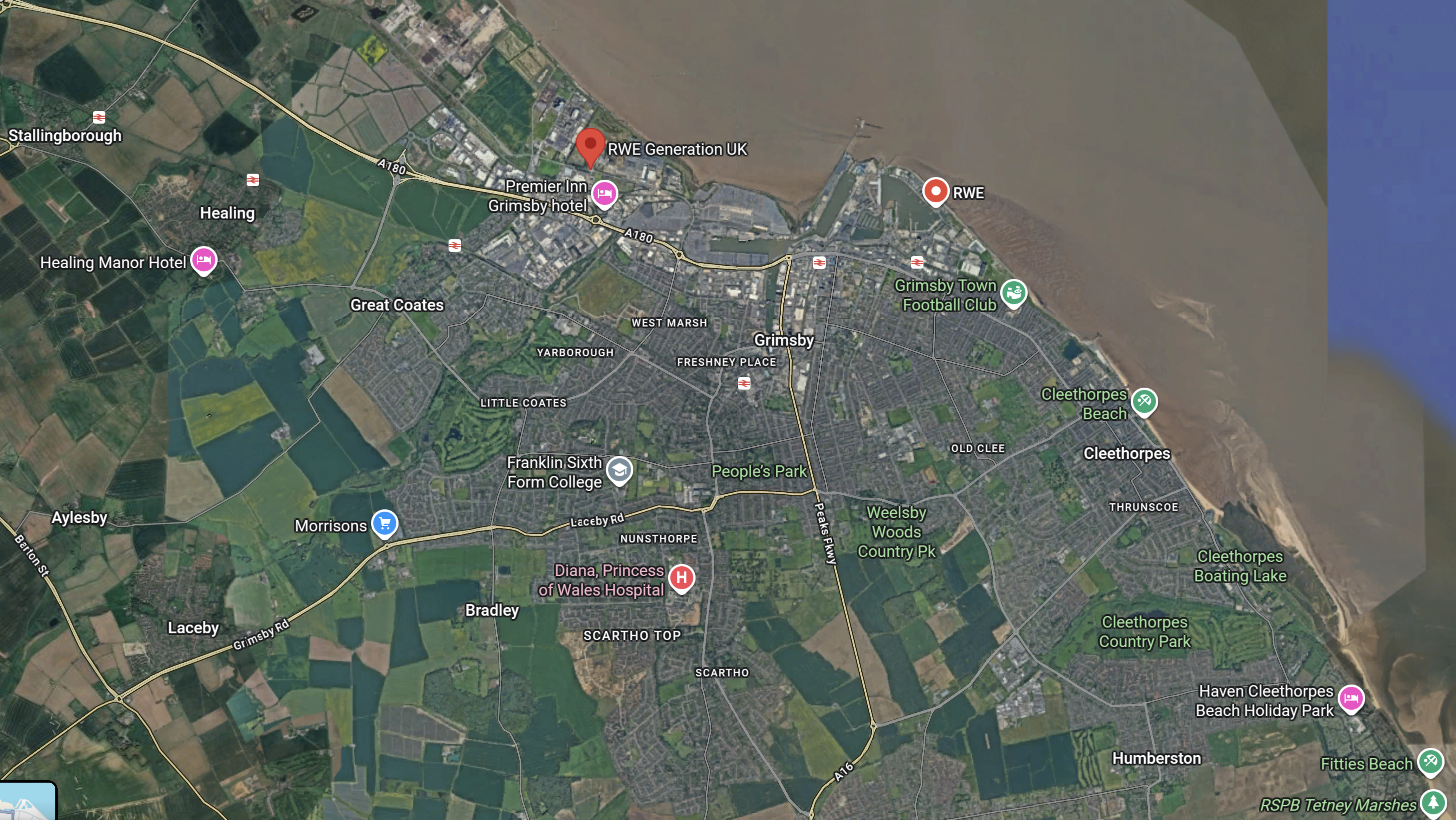
Note.
- The bright red arrow at the top of the map indicates RWE Generation UK in Grimsby Docks.
- There is another RWE location to the right of the bright red arrow.
- There is a line of stations along the coast, which from left-to-right are Stallingborough, Healing, Great Coates, Grimsby Town, Grimsby Docks, New Clee and Cleethorpes.
- Cleethorpes is not shown on the map.
- Doncaster and Cleethorpes are 52.1 mile apart, which is within the range of a battery-electric Hitachi and other trains.
- Charging would be at Doncaster, which is fully electrified and at Cleethorpes, by a short length of electrification.
This OpenRailwayMap shows the layout of and the railways around Grimsby Dock.

Note.
- Cleethorpes station is indicated by the blue arrow, in the South-East corner of the map.
- Cleethorpes station has four platforms, but no electrification.
- Grimsby Docks are to the North of the railway to Cleethorpes.
- This Wikipedia entry for Cleethorpes station, shows other railways and light railways served the area. Some were even electric.
These are a few of my thoughts on the development of railways between Sheffield and Cleethorpes.
RWE Will Be A Large Driver Of Employment In Grimsby
Earlier I wrote.
- Does RWE’s new UK Centralised Control Room control all their UK offshore wind farms?
- I have added them all up and there are almost 12 GW around our shores.
- I’ve read somewhere, that RWE are the UK’s largest power generator. From these figures, that would not surprise me.
It’s a long time, since I’ve added resources to a large project, so I asked Google AI, “How many people are needed to support a 1 GW offshore wind farm in the UK?”, and received this answer.
Direct & Indirect Support: For a large-scale project, this often breaks down into approximately 100–150 direct, permanent, high-skilled roles (technicians, engineers, management) and hundreds more in indirect, contracted, or supply chain roles (vessel crews, port operations, logistics).
Industry Average: Studies suggest that for operations and maintenance (O&M), around 50–100 full-time equivalent (FTE) jobs are generated per GW of installed capacity in terms of direct, permanent staff.
Key Takeaways for a 1 GW Farm:
- Direct Technicians/Operators: ~100–200+ (working on-site, turbines, or in control rooms).
- O&M Support Services: ~300–400+ (vessel operators, port logistics, supply chain).
- Total Operations Personnel: 300–600+ people.
Google AI appeared to have borrowed the figure from Ørsted and Hornsea 1 and 2.
So if it’s correct, there will be a total of 7,200 personnel supporting RWE’s wind farms in the UK. Even if only a third were employed in Grimsby, that is still a lot of people to accommodate and who will need to travel to work.
I also think a lot of personnel will come in by train, as the station is close to RWE’s locations.
Will Grimsby Have An Aberdeen-Sized Office-Shortage Problem?
One of the biggest problems, I was always hearing in the 1970s, was the shortage of offices in Aberdeen for the use of the oilmen.
In RWE Goes For An Additional 10 GW Of Offshore Wind In UK Waters In 2030, I talked about RWE’s plans for the future and published this table of new wind farms.
- Sofia – 1,400 MW
- Norfolk Boreas – 1380 MW
- Norfolk Vanguard East – 1380 MW
- Norfolk Vanguard West – 1380 MW
- Dogger Bank South – 3000 MW
- Awel y Môr – 500 MW
- Five Estuaries – 353 MW
- North Falls – 504 MW
Note.
- Sofia is nearly complete.
- Only the three Norfolk and the Dogger Bank South wind farms are on the East side of England and suitable to be serviced from Grimsby., but they still total 7,140 MW.
Has Grimsby got the office-space for all the people needed?
Could The Cleethorpes And Liverpool Lime Street Service Be Run By Battery-Electric Rolling Stock?
The various sections of this route are as follows.
- Cleethorpes and Doncaster – No Electrification – 52.1 miles
- Doncaster and Meadowhall – No Electrification – 15.2 miles
- Meadowhall and Sheffield – No Electrification – 3.4 miles
- Sheffield and Dore & Totley – No Electrification – 4.2 miles
- Dore & Totley and Hazel Grove – No Electrification – 29.2 miles
- Hazel Grove and Stockport – Electrification – 3.3 miles
- Stockport and Manchester Piccadilly – Electrification – 5.9 miles
- Manchester Piccadilly and Deansgate – Electrification – 0.8 miles
- Deansgate and Liverpool South Parkway -Not Electrified – 28.2 miles
- Liverpool South Parkway and Liverpool Lime Street – Electrified – 5.7 miles
Adding the sections together gives.
- Cleethorpes and Hazel Grove – No Electrification – 104.1 miles
- Hazel Grove and Deansgate – Electrification – 10 miles
- Deansgate and Liverpool South Parkway -Not Electrified – 28.2 miles
- Liverpool South Parkway and Liverpool Lime Street – Electrified – 5.7 miles
Note.
- To cover the 104.1 miles to Hazel Grove battery-electric trains would probably need to leave Cleethorpes with full batteries.
- Doncaster is a fully-electrified station and passing trains may be able to have a quick top-up.
- In South Yorkshire Now Has Better North-South Connections, I calculated that Doncaster is a very busy station with 173 express trains per day calling at the station or one every 8.5 minutes.
- Will trains be able to stop for a long period to charge batteries?
- It may be prudent to electrify between Meadowhall and Sheffield, under the Midland Mainline Electrification.
- Sheffield and Dore & Totley is shown that it will be electrified, under the Midland Mainline Electrification.
- Do we really want to have electrification marching along the Hope Valley Line?
- I believe that hydrogen-hybrid locomotives will be a better solution for freight trains on scenic lines like the Hope Valley, as they are zero-carbon, powerful and with a range comparable to diesel.
I believe CAF, Hitachi and Siemens have off the shelf rolling stock and factories in this country, who could build trains for the Cleethorpes and Liverpool Lime Street route.
How Would You Charge Battery-Electric Trains At Cleethorpes?
This picture shows Cleethorpes station
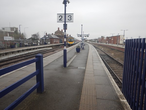
Note.
- The four long platforms without electrification.
- The platforms have recently been refurbished.
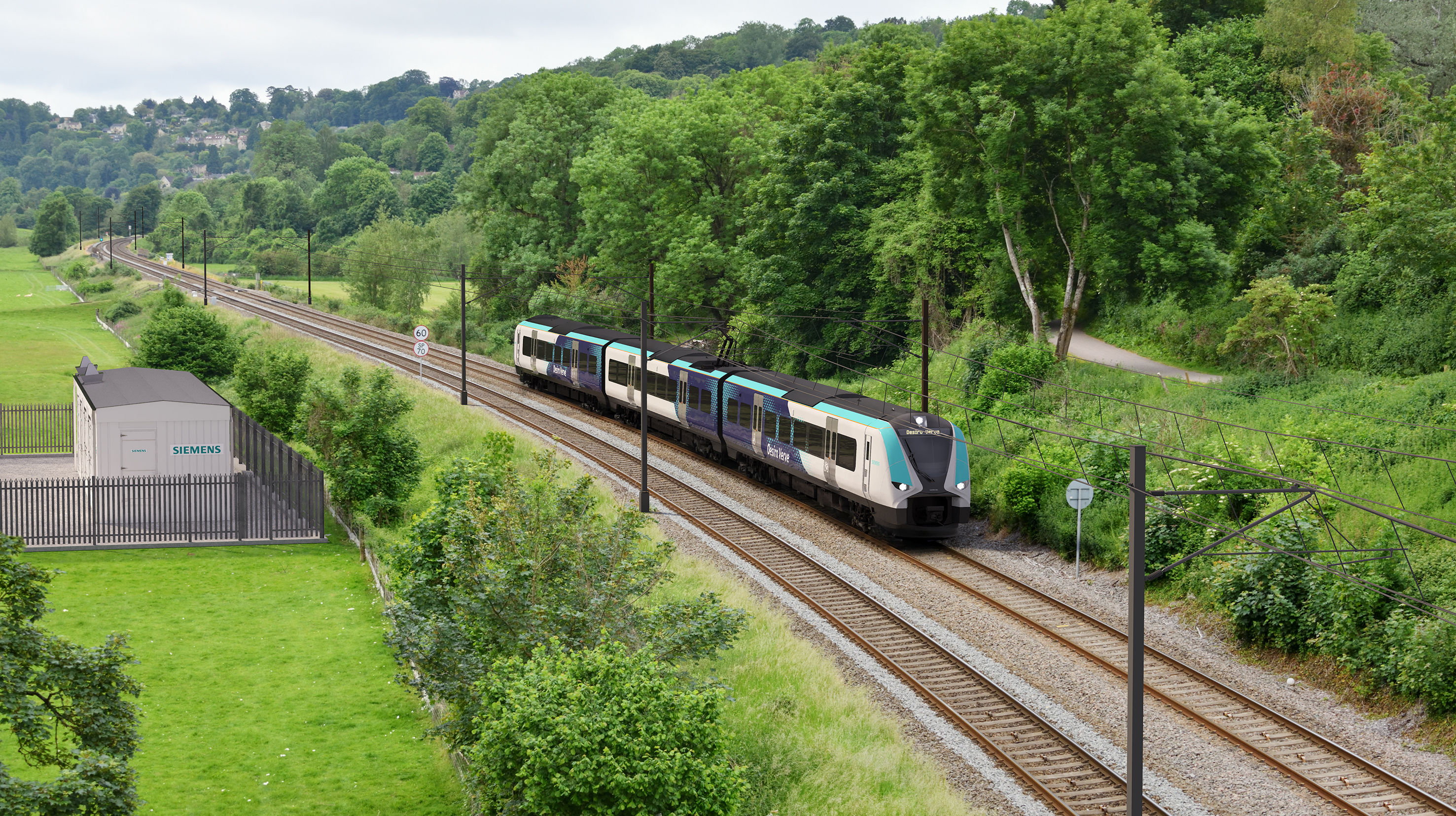
- The train in Platform 2 is a TransPennine Express Class 185 Siemens Desiro diesel train.
The simplest way to electrify the station would be to put up enough 25 KVAC overhead wires, so that battery-electric trains needing a charge could put up a pantograph and have a refreshing drink.
In Technology Behind Siemens Mobility’s British Battery Trains Hits The Tracks, I wrote about Siemens Rail Charging Converter.
This is a visualisation of a Siemens Rail Charging Converter in action.
Note.
- The track is electrified with standard 25 KVAC overhead electrification.
- The train is a standard Siemens electric or battery-electric train.
- Siemens Rail Charging Converter, which is the shed in the compound on the left is providing the electricity to energise the catenary.
- I suspect, it could power third rail electrification, if the Office of Rail and Road ever allowed it to be still installed.
- The Siemens Rail Charging Converter does have one piece of magic in the shed. I suspect it uses a battery or a large capacitor to help power the electrification, as it can be powered from any typical domestic grid supply.
- I also wonder, if it has safety devices that cut the power outside the shed if track workers or intruders are detected, where they shouldn’t be?
- It could even cut the power, when trains are not running to save power and increase safety.
This looks to me, that a Siemens Rail Charging Converter could be a superb example of out-of-the-box thinking.
Could The Cleethorpes And Barton-on-Humber Service Be Run By Battery-Electric Rolling Stock?
This OpenRailwayMap shows the railways of North-East Lincolnshire.
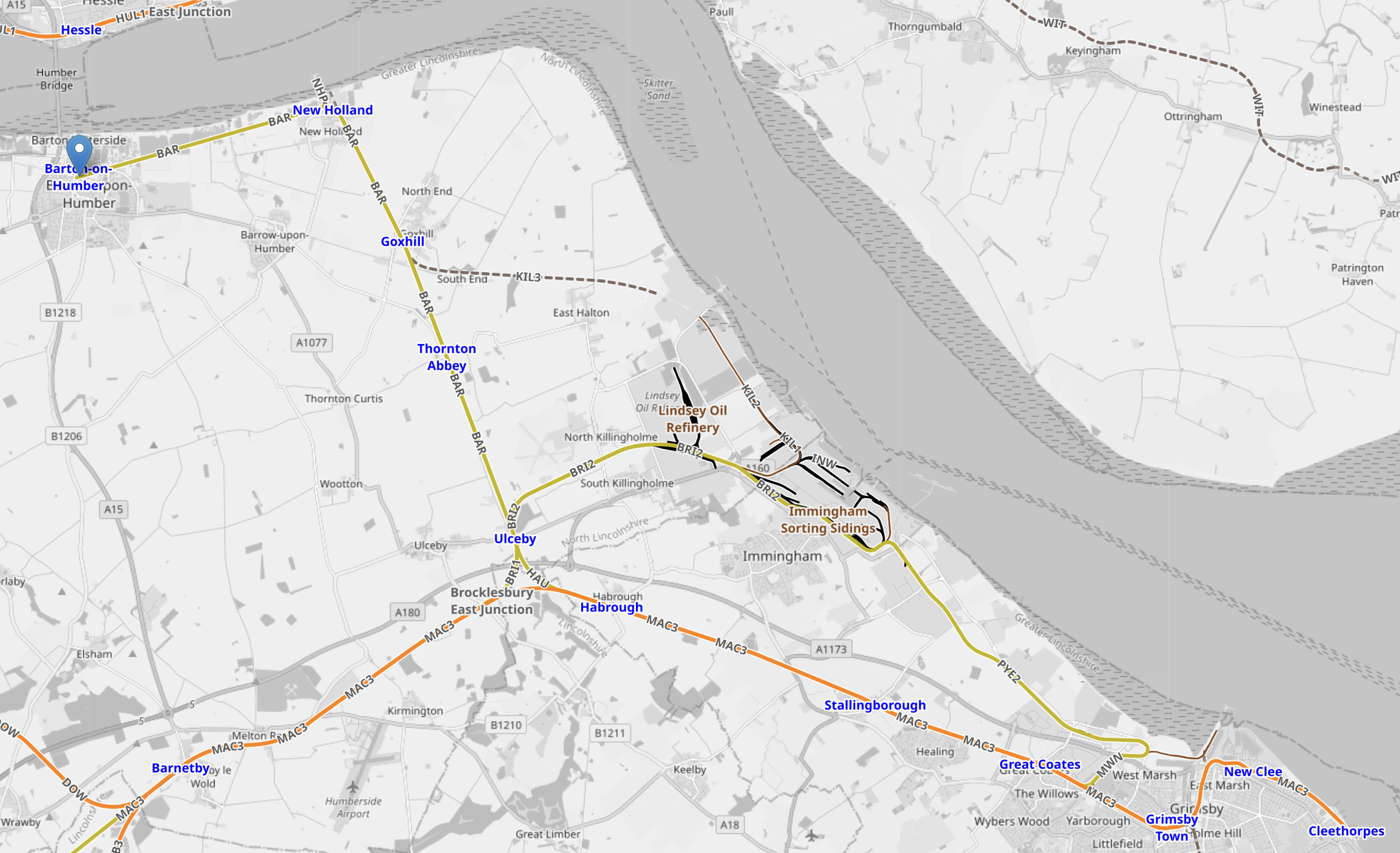
Note.
- Cleethorpes is in the South-East Corner of the map.
- Barton-on-Humber is in the North-West corner of the map and marked by a blue-arrow.
- Stations from South to North would be New Clee, Grimsby Docks, Grimsby Town, Great Coates, Healing, Stallingborough, Habrough, Ulceby, Thornton Abbey, Goxhill, New Holland and Barrow Haven.
- The line is double track.
- Cleethorpes and Barton-on-Humber is just 22.8 miles.
- A round trip would be under fifty miles, which would be well within range of a full-charge at one end.
- Service is one train per two hours (tp2h), which would only need a single train, shuttling between Cleethorpes and Barton-on-Humber.
- Two trains could provide an hourly service.
I would expect, that well-designed, solid and reliable German engineering could build a Siemens’ Rail Charging Connector that could charge four trains per hour (tph) at Cleethorpes station.
At present services are.
- TransPennineExpress – 1 tph to Liverpool Lime Street.
- East Midlands Railway – 1 tp2h to Barton-on-Humber
- East Midlands Railway – 1 tp2h to Matlock via Lincoln and Nottingham
- Northern Trains – 1 train per day (tpd) Sheffield via Brigg.
That is probably only about two tph.
Could The Cleethorpes And Sheffield Service Be Run By Battery-Electric Rolling Stock?
This is a description of the current Cleethorpes and Sheffield service.
- It is run by Northern Trains.
- The morning train leaves Sheffield at 09:54 and arrives in Cleethorpes at 11:40.
- The afternoon train leaves Cleethorpes at 13:20 and arrives in Sheffield at 15:10.
- The train is a Class 150 diesel train, which is a bit of a Joan Collins of a train – Of a certain age, but still scrubs up extremely well!
- Intermediate stations are Worksop, Retford, Gainsborough Central, Kirton Lindsey, Brigg, Barnetby and Grimsby Town
- The route length is 71.6 miles
- Trains take about 45-50 minutes.
It is also a parliamentary train.
The Wikipedia entry for parliamentary train gives this description of the Cleethorpes and Sheffield service.
Via Kirton Lindsey & Brigg. Became a parliamentary service when weekday services were withdrawn in 1993. Regular trains have operated between Gainsborough and Sheffield for most timetable periods since. Suspended January 2022 by Northern, who cited COVID-19 and staffing issues , but the service was reinstated in December 2022. Changed in May 2023 to be one return journey on weekdays only.
In the 1950s and 1960s I lived in Felixstowe part of the time and in the 1970s and 1980s I lived near Woodbridge and I observed first hand the development of the Port of Felixstowe and the effects it had on the surrounding countryside.
The development of the Port of Felixstowe, has brought the following.
- Improved roads and railways.
- Ipswich is now an hour from London by train.
- Ipswich is now a University town.
- New housing and other developments, both in Ipswich and Felixstowe and the surrounding countryside.
- Employment also has increased considerably, both in the Port and in surrounding towns.
- Ipswich’s football team is very much respected all over Europe and has won the English top division, the FA Cup and the UEFA Cup.
When you consider the jobs that RWE could create in the Port of Grimsby, I believe that this could have similar effects in Grimsby and Cleethorpes, as the Port of Felixstowe had in East Suffolk.
Already, the following are being talked about.
- A direct rail link between Cleethorpes and Grimsby to London.
- Battery-electric trains between Cleethorpes and Grimsby and Doncaster, Manchester and Liverpool Lime Street.
I believe that an improved rail link between Cleethorpes and Sheffield could be the catalyst for much needed housing along the route, which would be to the benefit of Cleethorpres, Grimsby, Sheffield and all the intermediate towns and villages on the route.
and the affects this will have on the countryside around the town, I believe that a strong case can be made out for a more frequent service between Cleethorpes and Sheffield.
E.ON Invests £4 million In Allume Energy To Boost Solar Rollout For Flats
The title of this post, is the same as that of this article on Solar Power Portal.
These three paragraphs explain the deal and say a small amount about Alume’s SolShare system.
Energy supplier E.ON UK has today (17 June) announced that it has signed a strategic investment agreement with Australian firm Allume Energy to help the firm expand into the UK.
E.ON UK has invested £4 million into Allume Energy to enable Allume to expand the reach of its SolShare technology within the UK market. SolShare allows solar energy from a single rooftop solar PV installation to be fairly shared amongst multiple homes in the same building in order to allow residents of flats to access solar PV energy.
Residents are supplied their energy when they are using by a pre-determined allocation, allowing them to lower their energy bills. Many blocks of flats that do have solar panels fitted currently only use this energy to power the common areas of the building while residents still pay their full electricity bill. According to Allume, a shared rooftop solar PV system can reduce resident energy bills by between 30% and 60%.
I must say, that when I read this article, it had something of the too-good-to-be-true about it.
But.
- My solar installation on a fair-sized roof cost me about £6,000 and I am constantly surprised at how much electricity it provides.
- If you have fifty flats, they all won’t do their weekly washing at the same time each week.
- I wouldn’t be surprised to see a big battery somewhere or a small battery in each flat.
- The batteries could soak up any excess electricity or charge on cheap-rate overnight electricity.
- Do Allume’s engineers go through every flat and make suggestions about saving energy?
- Is the pattern of electricity usage in a block of flats predictable from past usage and factors like weather, the time of the year and what’s on television?
- I wouldn’t be surprised that Allume have performed extensive mathematical modelling on blocks of flats.
I think this deal could be a winner foe E.ON, Allume and their customers.
I have some ideas about the use of the system.
Would It Work On A Small Housing Estate?
A small housing estate would be a number of solar roofs feeding a number of houses, whereas with flats it will be one roof feeding a number of dwellings.
I suspect that with a well-designed sharing and pooling system, a lot of features of the flat-powering system could be used to power houses.
How Does The System Handle Electric Vehicles?
The system could use these to store electricity, so that they are always charged at the cheapest rate.
And when there is a shortage of electricity, the electricity could be borrowed by the Allume system.
Conclusion
If you have community sharing their own source of electricity, you can probably make ideas work, that wouldn’t in a single application.
My nose says Allume’s idea has legs.
Could The Silvertown Tunnel Handle More Buses?
In A Return Journey Through The Silvertown Tunnel On A 129 Bus, I took these pictures inside the Silvertown Tunnel when the bus was coming North.


Note.
- The left lane is marked Bus Lane.
- Only one car is visible in the right lane.
- The tunnel seems well-lit.
I have some thoughts
Where’s The Traffic?
It does appear that two apparently empty lanes in each direction, don’t carry a large number of vehicles.
- Have the tolls and arguments frightened traffic away?
- Are the tolls too high?
- From the full set of pictures in the linked post, it would appear more vehicles were using the Blackwall Tunnel.
- Could it be that drivers are frightened of getting a speeding ticket?
- Are drivers frightened of sharing the tunnel with buses and heavy trucks?
Both bores of the Silvertown Tunnel seem to have similar traffic levels.
What’s The Capacity Of A Bus Lane?
In the Wikipedia entry for bus lane, this is said.
The busiest bus lane in the United States is the Lincoln Tunnel XBL (exclusive bus lane) along the Lincoln Tunnel Approach and Helix in Hudson County, New Jersey, which carries approximately 700 buses per hour during morning peak times an average of one bus every 5.1 seconds.[ In contrast, the Cross-Harbour Tunnel in Hong Kong carries 14,500 buses per day, or an average of about 605 an hour all day (not just peak times), but the bus lane must give way to all the other road users resulting in long queues of buses.
Perhaps a more realistic example of tunnel capacity from the UK, would be the Victoria Line, which handles thirty-six * eight-car trains per hour (tph) in both directions in two tunnels.
I would certainly expect that if Dear Old Vicky can manage 36 x 8-car trains per hour, then the Silvertown tunnel could handle thirty-six buses per hour.
Especially, if the buses had a distance keeping capability, as many trains do.
How Many Buses Per Hour Are Planned to Use The Silvertown And Blackwall Tunnels?
This handy map from Transport for London, shows the three bus routes passing through the Silvertown and Blackwall Tunnels.
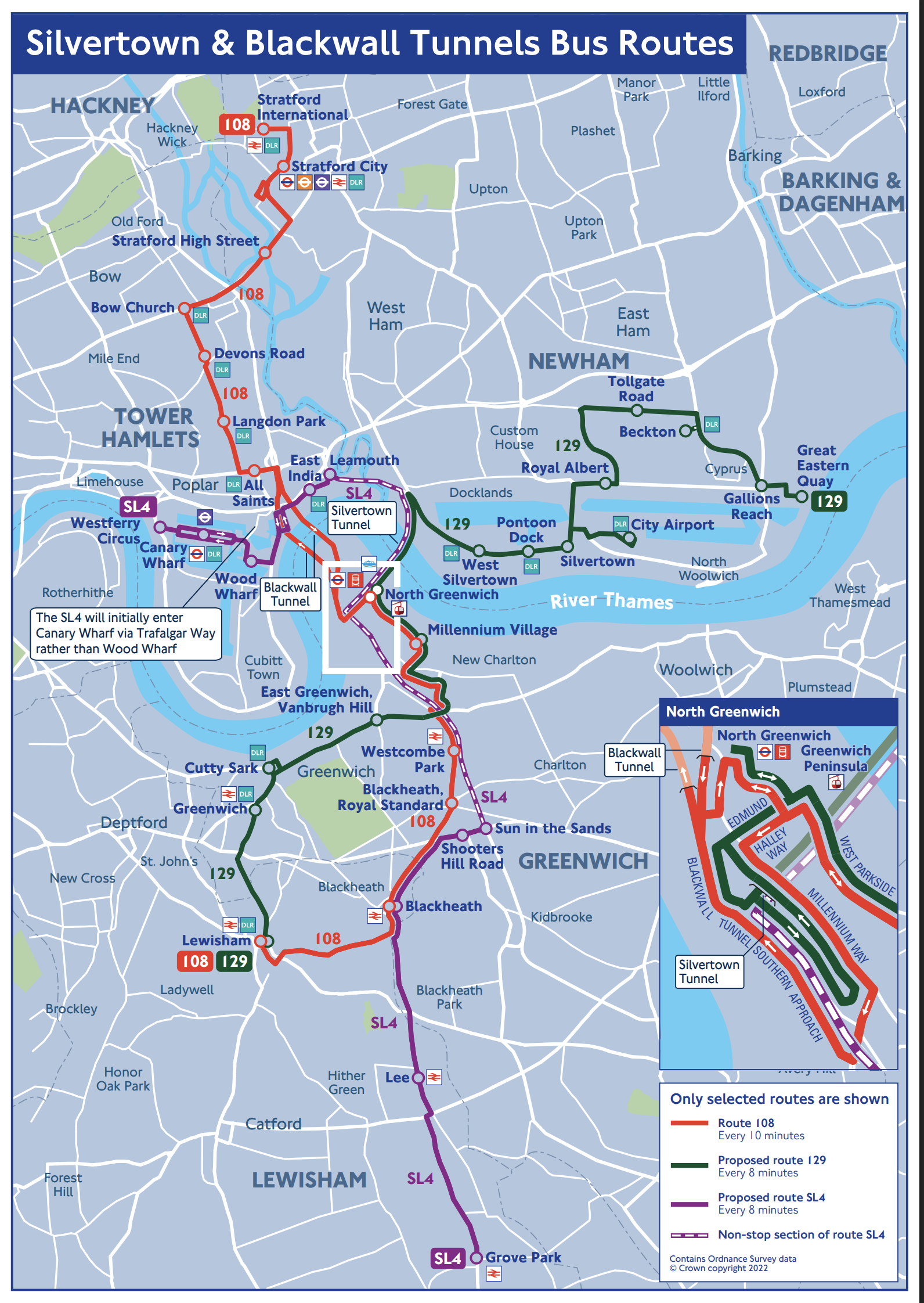
Click the map to show it to a larger scale.
The map gives these frequencies for the three bus routes using the tunnels.
Bus Route SL4
Operates once every 8 minutes or at seven buses per hour.
Bus Route 108
Operates once every 10 minutes or at six buses per hour.
Bus Route 129
Operates once every 8 minutes or at seven buses per hour.
Silvertown Tunnel Bicycle Shuttle
Google AI says this.
The Silvertown Tunnel cycle shuttle bus runs approximately every 12 minutes, operating daily from 6:30 am to 9:30 pm, except for Christmas Day, offering a safe and quick way for cyclists to cross the Thames.
This operates at five buses per hour.
Number Of Buses Through The Tunnels
There will be around nineteen buses per hour, through the Silvertown Tunnel and six through the Blackwall.
The Silvertown Tunnel looks like it has been designed to accept more buses.
One thing this means, is that if the Blackwall gets shut, then the 108 can use some of the spare capacity in the Silvertown Tunnel.
Could A Coach Station For Europe Use Some Of The Spare Capacity?
In Development To The West Of The North Entrance Of The Silvertown Tunnel, I displayed this.
This Google Map shows the site to the West of the North entrance of the Silvertown Tunnel.
Note.
- The red arrow indicates City Hall.
- There is a large site between the DLR and the river.
- The Docklands Light Railway separates the site from the North entrance of the Silvertown Tunnel.
- The CEMEX Thames Aggregate Wharf seems to occupy part of the site.
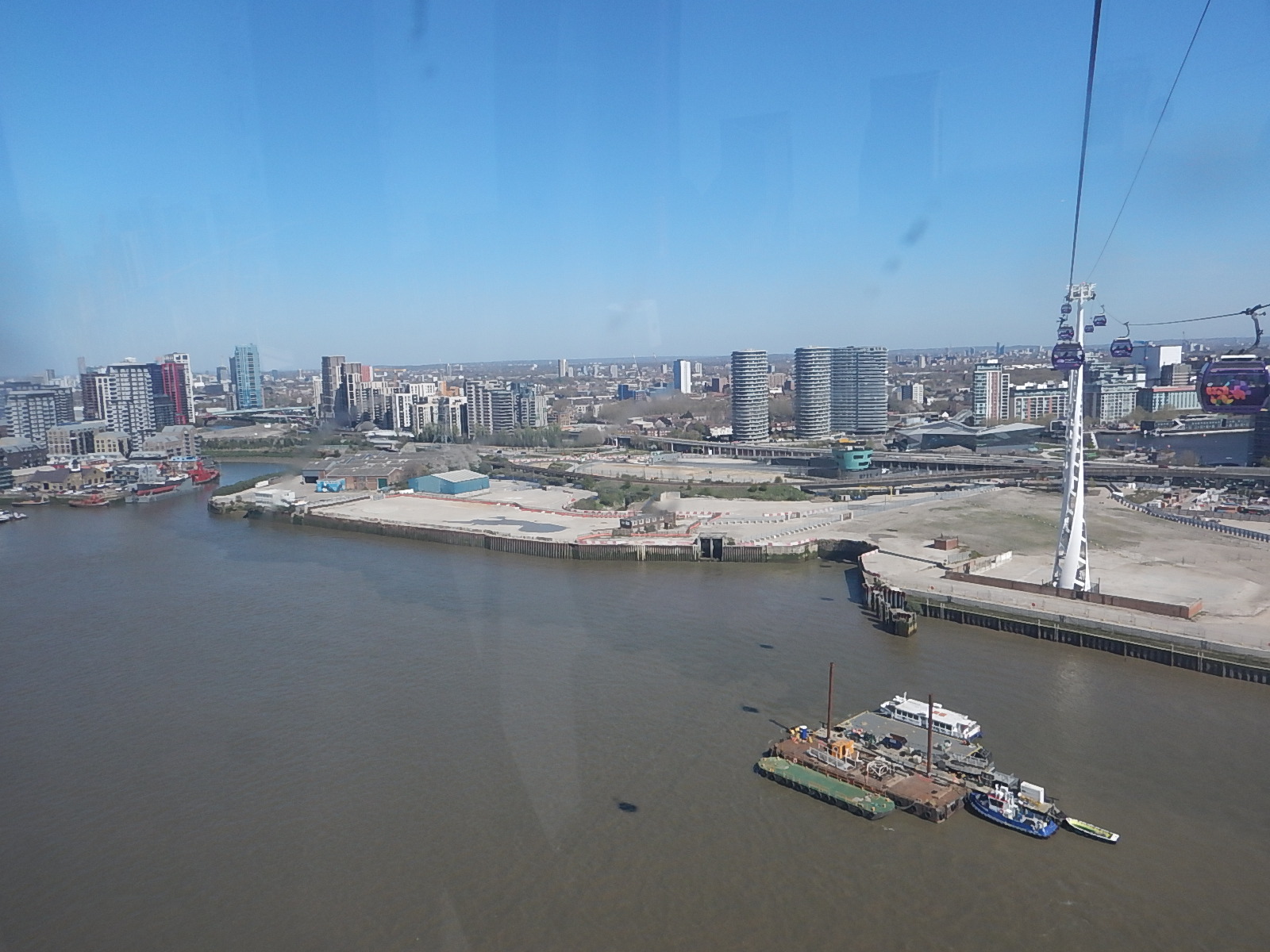
This picture shows the North entrance of the Silvertown Tunnel from the cable-car.
It is surely a site with development potential, as Roy Brooks would say.
It will probably be used for more tower blocks along the Thames.
But could it be used for a coach station to handle the increasing number of coaches between London and the Continent?
- A Docklands Light Railway station could be built to serve the site.
- Thames Clippers could also serve the site.
- Coaches could use the Silvertown Tunnel to start their journey out of the capital.
It is certainly a possibility.
Could The Silvertown Tunnel Be Used For Route-Proving For The Docklands Light Railway?
In TfL Considering Extending DLR As Far As Abbey Wood, I discussed extending the Docklands Light Railway to Thamesmead or Abbey Wood.
This map from Ian Visits shows the area.

Running a four buses per hour service through the Silvertown Tunnel, would be an ideal way of proving what is the best route.
Extending The Docklands Light Railway To The West
No matter how the Docklands Railway is extended to the East, either by physical means like extra branches or by virtual means like connecting to bus routes, this will mean that there will need to be more terminal capacity in the West, to take the pressure off Bank and Tower Gateway stations.
In A Connection Between City Thameslink Station And The Docklands Light Railway, I described a proposal to extend the Docklands Light Railway to Euston, St. Pancras and Victoria.
In the Wikipedia entry for the Docklands Light Railway, there is a section describing a proposed Euston/St. Pancras Extension.
This is said.
In 2011, strategy documents proposed a DLR extension to Euston and St Pancras. Transport for London have considered driving a line from City Thameslink via Holborn north to the rail termini. The main benefit of such an extension would be to broaden the available direct transport links to the Canary Wharf site. It would create a new artery in central London and help relieve the Northern and Circle lines and provide another metro line to serve the High Speed line into Euston.
This map from Transport for London, shows the possible Western extension of the DLR.
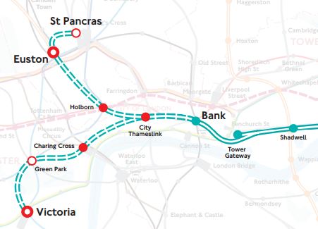
With all the problems of the funding of Crossrail 2, that I wrote about in Crossrail 2 Review Prompts Fresh Delays, could this extension of the DLR, be a good idea?
Consider.
- Victoria, Euston and St. Pancras are prosposed Crossrail 2 stations.
- It would link Canary Wharf and the City of London to Eurostar, Northern and Scottish services and High Speed Two.
- It would give all of the Docklands Light Railway network access to Thameslink.
- A pair of well-designed termini at Euston and St. Pancras would probably increase frequency and capacity on the Bank branch of the system.
- The DLR is getting new higher capacity trains.
- Bank station is being upgraded with forty percent more passenger capacity.
- Holborn station is being upgraded and hopefully will be future-proofed for this extension.
- One big advantage at City Thameslink, is that Thameslink and the proposed DLR extension will cross at right-angles, thus probably making designing a good step-free interchange easier.
- The Bank Branch of the DLR currently handles 15 tph, but could probably handle more, if they went on to two terminal stations at St Pancras and Victoria..
- Waterloo and City Line can run at twenty-four tph.
Cinderella she may be, but then she always delivers, when there is a desperate need, just as she did magnificently at the 2012 Olympics.
Something is needed to handle the extra passengers at Euston, that will be brought to London by High Speed Two. Cinderella is the only way to deliver a connection in a reasonable time.
The only problem with this extension of the DLR, is that compared to the rest of the system, the views will be terrible.
For myself and all the others living along the East London Line, with a step-free change at Shadwell, we would get excellent access to Euston, St. Pancras and Victoria.
But could the line still be called the Docklands Light Railway, as it spreads its tentacles further?
Development To The West Of The North Entrance Of The Silvertown Tunnel
This Google Map shows the site to the West of the North entrance of the Silvertown Tunnel.
Note.
- The red arrow indicates City Hall.
- There is a large site between the DLR and the river.
- The Docklands Light Railway separates the site from the North entrance of the Silvertown Tunnel.
- The CEMEX Thames Aggregate Wharf seems to occupy part of the site.
This picture shows the North entrance of the Silvertown Tunnel from the cable-car.
It is surely a site with development potential, as Roy Brooks would say.
It will probably be used for more tower blocks along the Thames.
But could it be used for a coach station to handle the increasing number of coaches between London and the Continent?
- A Docklands Light Railway station could be built to serve the site.
- Thames Clippers could also serve the site.
- Coaches could use the Silvertown Tunnel to start their journey out of the capital.
I added these pictures, that were taken of the site from the Docklands Light Railway, a day later.


The site certainly has development potential.
