Buses In West London
I have taken quite a few buses in West London in recent days.

A Rather Tired West London Bus
But I can’t help feeling that the quality of some is not what we would put up with in the East.
The single-decker shown seemed rather tired with only an intermittently working information system and it seemed to struggle its way around. Luckily, I knew I wanted to get off at Ealing Hospital, which although it wasn’t announced by the bus, the hospital was obvious, as there wasn’t another large building with numerous ambulances in front.
Tottenham Hale’s New Bus Station
The bus station attached to Tottenham Hale station doesn’t appear to be far off opening.
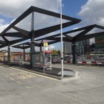
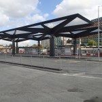
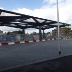

It seems the architect has managed to keep the design simple, whilst still looking spectacular.
From what I can remember of the old bus stands in the area, this design appears to make more efficient use of space. Which hopefully, will mean changing buses will be less far to walk.
Click for a map of the new bus station.
The new bus station will probably not make much difference to me, as I only use the bus from here to get to and from IKEA only occasionally.
When they finally open the station at Lea Bridge, I will probably use that a lot more.
Does Sheffield Need A Bus Tram?
Sheffield is an unusual city in the UK, in that it has lots of hills.
On Tuesday night, when I went to Carluccio’s on the Ecclesall Road it meant that I hsd to get a bus, as this was off the tram route, which only has a fixed route through the city.
It was not the easy journey it would have been on the tram, as ordinary buses don’t have enough information on them. So although, I got off in almost the right place, the journey would have been less fraught on a tram.
It looked to me that the Ecclesall Road has a lot of buses, but just as I have locally the route 38, which I nickname the Hackney Tram, would it be better if Sheffield had a fleet of modern buses that had some of the features that tram passengers like, such as information, on-board staff, comfortable seats and disabled access.
This type of operation needs no new infrastructure and you can add and subtract vehicles to the route as required. Buses like London’s new Routemasters may also make lighter work of the hills. I’m not sure of the figures, but I think a good hybrid bus has more acceleration and short-term power than one with a large diesel. Our new Routemasters do have a touch of the Linford Christies.
Sheffield’s Information-Free Buses And Trams
I chose the Leopold Hotel, as it was in the centre by a tram stop, which made it easy to get to and from the match at Hillsborough. It also meant that to get to the hotel from the train, I just went to the tram stop and used my Freedom Pass to go a few stops up the hill.
But when I arrived at the stop, all it had was details on the tram route. But there was no sign of any local map. As I’d spotted the hotel from the tram before it stopped, I just walked a few metres down the hill and round the corner.
I had planned to have an early supper with an old friend, at the new Carluccio’s on Ecclesall Road. He’d said I’d needed to get an eighty-something. So I walked and found this bus stop.

The World’s Most Useless Bus Stop
Note that is says “Buses Do Not Stop Here on the sign. It didn’t have any information that a visitor might like to use to get to the Ecclesall Road. There was no information and nobody around to answer my question.
I eventually walked a couple of hundred metres the other way and found a guy, who told me that any bus from a particular stop went down the Ecclesall Road. The queues incidentally at the stop was manic, mainly because the ticketing system required many to give money to the driver. As usual I had to put my Freedom Pass down and pick up a printed ticket.
And when I did get on a bus, there was no way, I could tell where I was, as it was a silent bus. Luckily, I knew roughly, where I was going and I knew there was a Waitrose on the corner of Ecclesall Road. But I still ended up walking further than I wanted.
At least I could read the name on the bus stops, but how do the visually-impaired manage?
The bus wasn’t that full for the rush hour and that helped me look out. But I still had to fight my way to the front to get out.
If ever a city needed London’s bus spider maps and cash free buses it is Sheffield. How many more passengers would they get, if the buses and trams were organised with the same objectives as London in mind?
But the worst thing about the buses, was coming back from Ecclesall Road was that the buses seemed to have stopped running.
In the end I had to pay £6 for a taxi.
How visitor-friendly is that?
At least when I need to go to Sheffield in the future, I now know that unless I’m going to somewhere near a tram stop, the best course of action will be to stay at home.
Could London’s Passenger Counting Technology Look For Non-Payers?
I took another trip on a crowded 141 bus today and it had the passenger counting technology on board.
Passengers were fascinated and obviously some were using it to determine whether to go upstairs.
It struck me that as those entering the bus have to touch-in, by correlating this with spaces, it might be possible to determine how many passengers hadn’t touched-in.
It wouldn’t actually identify them individually, but by simple arithmetic it could probably identify routes with the highest levels of non-payers.
So if a particular area on route XX showed a high-level of non-payers, that is obviously where you send your inspectors.
Transport for London’s Latest Plot To Get Us To Climb Stairs
London’s buses are effectively computer terminals and displays, that just happen to carry passengers about the city.
These pictures that I took on route 141, show the latest software upgrade.
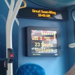

The clock has been shown on the Next Stop display for some time, but the display, showing how many spare seats are on the upper deck, is new.
Will it help to increase the loading of buses? The only problem, is that the system is not as attractive as a comely conductress calling politely for everybody to please move along the bus!
There’s more about the technology here on the IanVisits web site.
And Now We’ve Got A Blue Bus!
Adidas really know how to annoy Londoners, as they’ve now given us this disgusting blue bus.

And Now We’ve Got A Blue Bus!
The colour annoyed me so much, that I’ve decided to create the tag, Crap Marketing, in its honour.
A Road Death Database
The BBC has put together a database of all road deaths in the UK from 1999 to 2010.
I have looked at some areas and you can draw some interesting conclusions.
If I look at a typical London Borough like Hackney, the number of deaths is generally between 70 and 90. But some rural areas, despite less population have figures well over a hundred.
And then there’s the Oxford and Cambridge effect. Oxford has 34 deaths and Cambridge has just 16. Both these cities have extensive Park and Ride networks, good bus services and bikes are used quite a bit. But then Ipswich and Norwich also have low figures, but Colchester, Milton Keynes and Peterborough are higher.
So does a decent public transport network cut road deaths, as the drunks and the bad drivers are on the buses rather than in their cars?
If you look at the big northern cities like Liverpool, Leeds, Manchester and Newcastle, the figures would appear to be similar, but Newcastle is a lot less. Why?
Only by a serious analysis can we tell what is the reason!
Are Transport for London Doing Bit Of Route Proving?
I noticed this evening that London bus route 453 is to be Routemasterised next month.
I obviously don’t have the figures that TfL do, but is it a choice with a lot of implications for future public transport in the capital.
Route 453 has its Northern terminus at Marylebone, which is on the Bakerloo line. The route then calls at the following stations, which are also on that line.
- Baker Street
- Oxford Circus
- Piccadilly Circus
- Charing Cross
- Lambeth North
- Elephant and Castle
It then continues to New Cross, New Cross Gate and a couple of places mentioned as possible stops on the Bakerloo Line Extension.
As buses these days have extensive data collecting capabilities through Oyster, are TfL hoping to get specific traffic information, that might help in deciding where and when to extend the Bakerloo line? They might also be hoping that a quality bus route might flush out a few more passengers. The numbers using route 38, since the full Routemasterisation in May, certainly hasn’t decreased markedly, although in the summer there have been a few half-empty buses.
TfL obviously knows what to expect, as they have now converted several routes to New Routemasters.
But the only fact we know about traffic changes when New Routemasters take over a route, is that no statistics have been published.
I’d have loved to write a software system to analyse bus route performance.
It’ll be interesting to see how it all works through in the future.
If I take the route I know best, the 38, what would happen if the buses got to be very full?
I am drawn to the conclusion, that all TfL would do, would be to draft a few more buses on the route, which will be very easy, if there is only one type working the route.
Try doing that in a hurry with a tram route!
Inflated Balloons Are Allowed On Birmingham Buses
Unlike in Liverpool, inflated balloons are obviously allowed on Birmingham buses, as no-one objected to this group of people doing so.

Inflated Balloons Are Allowed On Birmingham Buses
Why should Liverpool have a ban, when no-one else seems to?
