Mini-Hollands
I wonder what the Dutch think of the naming of this project by Transport for London.
Walking From Harringay Station To Harringay Green Lanes Station
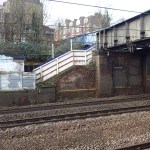
This is what Transport for London call an official out-of-station interchange and you can touch-out of one station and touch-in the other without getting charged.
So after visiting Palmers Green, I got on a train, which took me to Harringay station, from where I walked down the hill to Harringay Green Lanes station.

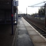


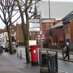


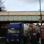
It was an easy walk and this could be a one-way interchange for some people, as the other way you’d walk up the hill.
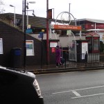
Harringay is a typical hole-in-the-wall station of which there are many over the UK.
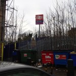
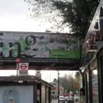
When I got onto Green Lanes, I saw the enormous mural on the bridge for the first time. It is promoting the Big Plan, which is all about improving the area.
As the Gospel Oak to Barking Line is being upgraded, do we have the classic stimulus for improvement of the area? The area has had all sorts of problems, that I can remember.
Bus Art
This is the first I’ve seen, but there are several over London.
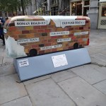
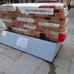

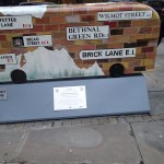
This one was by the Bank of England
There is more about the sculpture trails here.
The Spitalfields Snow Dome
Spitalfields have installed a snow dome for the season.


And it’s free to use.
Another Fare Free Friday
Last week’s Fare Free Friday was a success, as tube usage was a record.

Another Fare Free Friday
So they’re doing it again.
If doesn’t effect me, as I have a Freedom Pass, so every day is free. My Mastercard isn’t contactless either.
It’ll be interesting to see, who benefits most from this marketing exercise!
Can Any More Of London’s Smaller And Forgotten Railways Be Reused?
I ask this question, as last night and today, I got stuck in the City, because of monumental traffic jams due to roadworks and was thinking that perhaps the Waterloo and City Line might be extended North East from Bank to perhaps Liverpool Street and Shoreditch to create another route across the City. It would be good for me, as I would just go to Shoreditch High Street on the East London Line and then use the Waterloo and City to get to Waterloo.
Reading Wikipedia, I’m eighty years too late, as it says this under plans for the line in the 1930s.
In 1934 the London Passenger Transport Board (LPTB), operator of most of the London Underground system, proposed that the Waterloo & City should have a new intermediate station at Blackfriars, connecting with the District line station there. They further proposed that the Waterloo & City line should be extended to Liverpool Street station and Shoreditch, the trains there continuing over the East London Railway to New Cross and New Cross Gate. It is not clear whether the scheme had been costed, but nothing came of it.
It would probably be more difficult now to do anything sensible with this orphan line of the Underground.
A better plan would probably be to improve the trains and the station to a modern step-free standard and run at an increased frequency.
As the Central Line runs directly underneath the East London Line at Shoreditch High Street, it would seem logical that after Crossrail is completed, these two busy lines are connected.
But what of all the other smaller and forgotten railways in London. Can any be used to improve London’s transport system?
East London Line
The East London Line used to be a semi-detached part of the Metropolitan line, but is now been extended to be a very important part of the Overground.
It just shows how infrastructure can be reused successfully.
Transport for London are now talking about squeezing 24 trains per hour, up and down this line.
Greenford Branch Line
The Greenford Branch Line is one of the few remaining branch lines in the London area. Crossrail will see it cut back to a line from West Ealing to Greenford with four trains per hour.
Greenford itself is an unusual station, with two Central Line platforms on an island, that has a bay platform to accept the branch line trains. Platform sizes on the branch, mean that only two coach trains can be used.
According to Wikipedia, Ealoing council have proposed extending the line to West Ruislip in the North West and Clapham Junction in the South West.
I think it is true to say, that some very innovative thinking is needed to make something useful out of this line.
The only circumstances under which I can envisage anything radical happening, is if Chiltern Railways gets electrified and West Ruislip station gets rebuilt to allow the Greenford Branch to terminate there.
North London Line City Branch
Trains ran on the North London Line City Branch from Broad Street to Willesden Junction and onto Richmond.
Like the old East London Line the northern part of this line is part of the East London Line of the Overground.
I probably use the line at least half-a-dozen times a week.
Northern City Line
The Northern City Line used to be part of Underground, but since 1976 has been part of the suburban services to Welwyn Garden City, Letchworth and Hertford North.
The new franchise holder; Govia Thameslink Railway, has ambitious plans to replace the Class 313 trains on the line and extend the service hours. This document contains all the details on the new franchise.
Palace Gates Line
The Palace Gates Line ran from Seven Sisters to Palace Gates and I remember it well as a child, when I used to sit on ledgers in my father’s office in Station Road, Wood Green and watch the tank engines trundling up and down the line.
In my lifetime, it has probably never been viable as a working railway, but it seems that Crossrail 2 might run in tunnels along more or or less the same route, just as HS1 runs underneath the route of the North London Line. I suppose this might give construction advantages, if you want to sink something like a ventilation shaft down to the railway.
Romford to Upminster Line
The Romford to Upminster Line must be one of the smallest branch lines in the UK. It has just one track and three stations; Romford, Upminster and Emerson Park.
In some ways the surprising thing about the line, is that it has survived at all and has even been electrified.
But obviously, it is needed or has a very important politician living on the line, because it is being taken over by the London Overground in May 2015 and they’re even spending money on a brand-new train for the line.
After writing this I found that the Stourbridge Town branch line, is shorter with only two stations and claims to be the shortest branch line in Europe. But that line is not electrified and passengers are transported in Parry People Movers, which uniquely have flywheel drive!
As the operating speed on the Romford to Upminster line is just 30 mph, perhaps the company could come up with an appropriately-sized train for this line!
On the other hand if you read about the history of the line through Chafford Hundred Lakeside station, it says this.
The single track line through the area was opened in 1893 by the London, Tilbury and Southend Railway as part of a branch fromRomford to Grays via Upminster.
So perhaps, as the other part of the old branch serves the Lakeside Shopping Centre, it might be an idea to recreate the old branch line, as it would give this centre,Grays, Tilbury and possibly even London Gateway simple access to Crossrail. It would mean that the shopping centre would be just fifteen minutes away from Crossrail. The Shopping Line would get another attraction.
Conclusion
With the exception of the Greenford and Romford-Upminster branches, there doesn’t appear to be much scope for reusing any more of London’s old railway lines.
Buses In West London
I have taken quite a few buses in West London in recent days.

A Rather Tired West London Bus
But I can’t help feeling that the quality of some is not what we would put up with in the East.
The single-decker shown seemed rather tired with only an intermittently working information system and it seemed to struggle its way around. Luckily, I knew I wanted to get off at Ealing Hospital, which although it wasn’t announced by the bus, the hospital was obvious, as there wasn’t another large building with numerous ambulances in front.
Why Is London’s Transport So Well Mapped?
I’ve travelled all over the UK and a lot of Europe in recent years, and as I don’t drive, I have to use public transport.
What amazes me, is how poor mapping is in most cities and towns outside London.
There are exceptions like Munich, Glasgow and surprisingly, Ipswich, but most are pretty terrible. I’ve even had a letter in The Times complaining how bad the situation is in the UK.
So why is London so much more advanced with its maps, information and wayfinding?
In the 1920s and 1930s when the Underground was going through a major expansion, they probably had a problem with passengers not knowing where they could go!
So this led to Harry Beck‘s iconic Tube map, a version of which is still use today.
In the 1950s, when I started to explore London on my own, my mother told me that if I got lost to find a Tube station, as they had a tube map to me back to Oakwood and a local street map to find what I was looking for. It is still the same today, except that the tube map is more comprehensive and the local maps are generally larger and much better.
Over the last few years London has applied the pre-war principles to the buses, with bus route or spider maps that could have been designed by Harry himself and local walking maps at every bus stop with a shelter.
And then there’s Legible London and all its liths and fingerposts. Wikipedia sums it up like this.
Unlike other wayfinding projects, Legible London leaps over bureaucratic boundaries in order to provide one consistent visual language and wayfinding system across the city. This city–wide approach was implemented to help visitors and local residents to easily gain local geographic knowledge regardless of the area they are in.
In contrast if you go to the Manchester area, Manchester uses one design and Salford another.
London is different to other UK cities and most in Europe, in that it is so much larger.
Consequently, most Londoners are regularly a visitor in their own city, when they find themselves in a part of the city they don’t know.
And of course this applies to those who manage the city, so they appreciate the problem.
If you take a city like Nottingham or Liverpool, most of the locals probably have the city in their head, so they can’t see the point of providing consistent visitor information all over the area. And if it were to be installed, many locals would see it as a waste of money.
So I believe that London’s size is the main reason its information system is so good.
But you must add the tradition started by Harry Beck! He may not be lauded as a great artist, but surely the London Tube Map is one of the greatest examples of public art of all time.
Does London Need Devo Max?
In the Standard today, Labour politician, Margaret Hodge is asking this question and says that London needs it.
She says this about housing.
The capital’s population will be twice Scotland’s by 2030. Yet we already desperately lack the homes and infrastructure we need to meet the needs of 8.5 million Londoners. Our housing crisis dwarfs that of other parts of the country. Some 800,000 new homes are needed by 2020. Yet in the year to May, only 16,800 were built. Despite London’s great successes, we are becoming ever more grotesquely unequal. Inner London is increasingly only accessible to the very rich.
I would agree with some of what she says and go further to say that all cities and conurbations should have more powers.
The trouble is that it would change the political map of the UK for ever and think of all those bench warmers in Westminster, who would be out of a job.
But I do think that competition between cities would create jobs and better places to live. Some provincial cities need a real kicking to bring them into the twentieth century.
It would also be very good for London, if when they wanted to build something like Crossrail 2, they didn’t have to go cap-in-hand to the Government and compete with other necessary projects elsewhere.
If say London financed Crossrail 2 from its own resources and population, would anybody outside the capital have a right to complain? I don’t think so!
Could London’s Passenger Counting Technology Look For Non-Payers?
I took another trip on a crowded 141 bus today and it had the passenger counting technology on board.
Passengers were fascinated and obviously some were using it to determine whether to go upstairs.
It struck me that as those entering the bus have to touch-in, by correlating this with spaces, it might be possible to determine how many passengers hadn’t touched-in.
It wouldn’t actually identify them individually, but by simple arithmetic it could probably identify routes with the highest levels of non-payers.
So if a particular area on route XX showed a high-level of non-payers, that is obviously where you send your inspectors.
