Leading Transport Experts To Explore Innovative Options For The Watford To Croxley Link
The title of this post, is the same as that of this news item on the Watford Borough Council web site.
The news item starts with this sub-title.
A wide range of proposals to bring a long disused stretch of railway back to life as a key transport link between Watford and Croxley Green are to be explored…
These four paragraphs then outline what is to be done.
A wide range of proposals to bring a long disused stretch of railway back to life as a key transport link between Watford and Croxley Green are to be explored by three leading travel and transport consultancies.
Atkins, SYSTRA UK and Wood Group will work in partnership with Hertfordshire County Council, Watford Borough Council, Three Rivers District Council and Network Rail to provide innovative solutions to improve connectivity within the area.
The transport link will connect important areas of Watford like the town centre, hospital, Watford FC and Croxley Park with Croxley Green and Watford Junction and the travel network beyond.
Securing the right solution is an important part of the overall plans of the partnership and Network Rail for future cleaner, healthier and greener travel in the area for the benefit of residents, visitors and commuters.
Note.
SYSTRA UK and the Wood Group are respected consultancies.
The main railway station, town centre, football ground and the hospital should be connected together by decent public transport. In Watford, as in many towns, they currently are a long walk or a taxi.
Watford Junction and Croxley stations will be connected together.
These are my thoughts.
The Abbey Line
I believe that the Abbey Line, which links Watford Junction and St. Albans Abbey stations should be included in any proposals.
- It has a rather unusual timetable with trains running every forty-five minutes.
- Proposals exist for a passing loop, which would allow two trains per hour (tph)
- All stations only have a single platform.
If it were updated to a modern railway, it would be a valuable asset with charm.
Connecting St. Albans Abbey And St. Albans City Stations
This map from OpenRailwayMap shows the two stations.
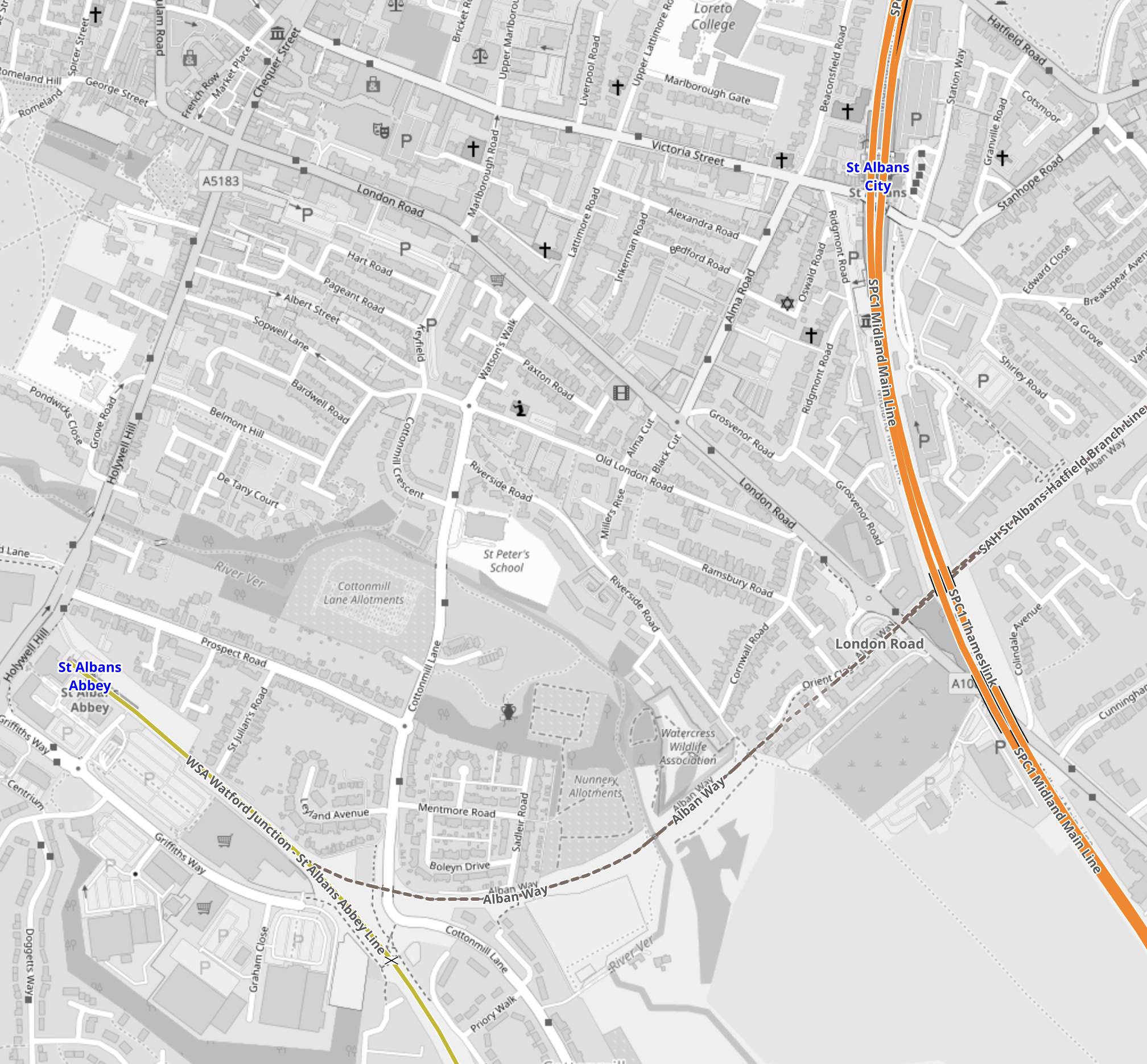
Note.
- The yellow line in the South-West corner is the Abbey Line that terminates in St. Albans Abbey station.
- The orange line is the Midland Main Line passes through St. Albans City station.
- The dotted line crossing the Midland Main Line and linking to the Abbey Line is a disused railway that has been converted into the St, Albans Way.
Tram-trains with a tight turning circle might be able to use the Abbey Line and with selected use of street running be able visit the City Centre and terminate at St. Albans City station.
Connecting The Abbey Line And The London Overground
This map from OpenRailwayMap, shows the track layout at Watford Junction station.
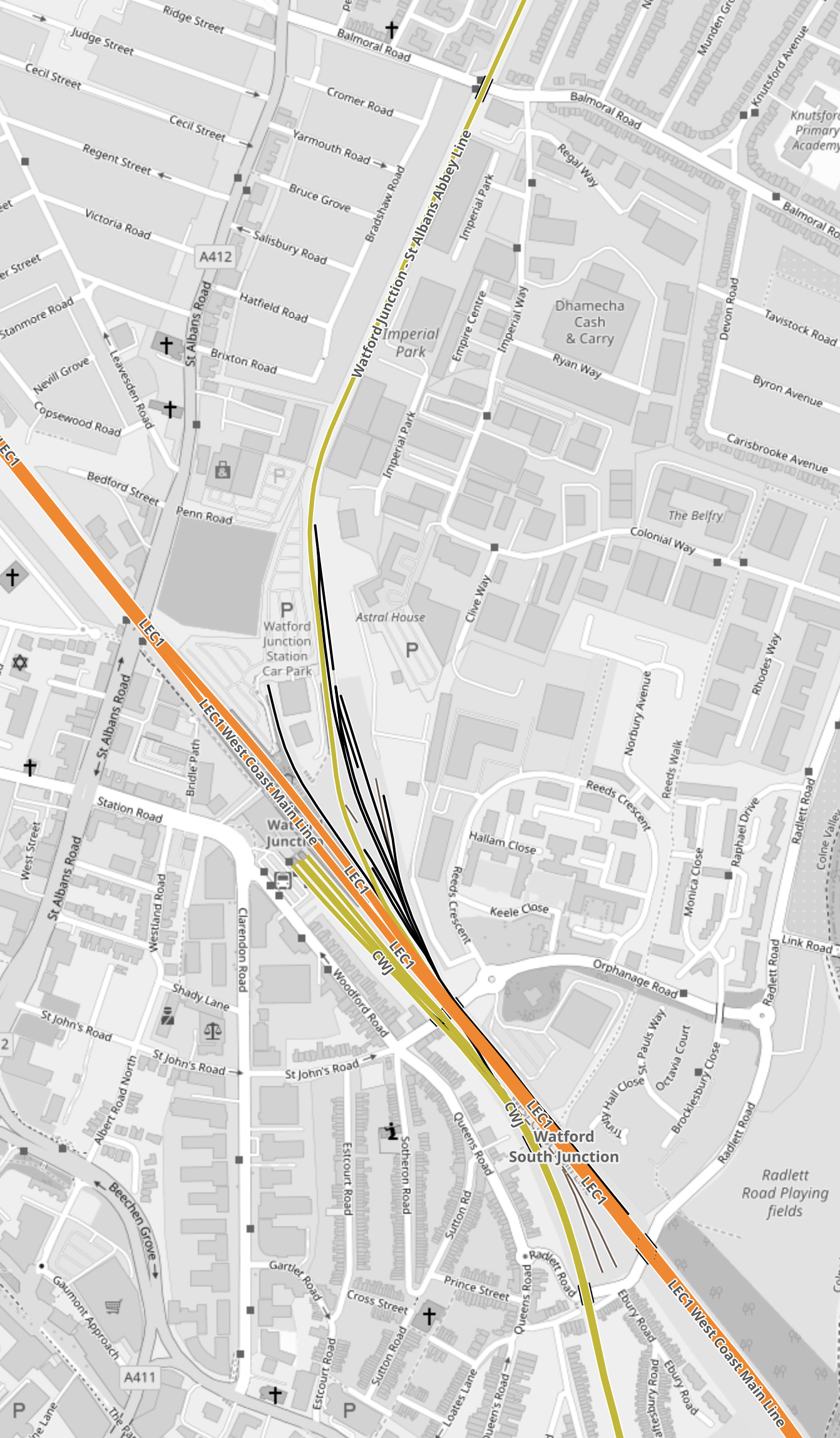
Note.
- The orange tracks are the West Coast Main Line.
- The yellow track to the North of the West Coast Main Line is the Abbey Line.
- The yellow track to the South of the West Coast Main Line is the Watford DC Line of the London Overground.
If you were using tram-trains, like the Class 399 tram-trains on the Abbey Line, I suspect a single-track dive-under could connect the Abbey Line with the Overground tracks to Watford High Street station.
Why Tram-Trains?
Tram-Trains have advantages in a scheme like this.
- They can run as trams on the streets.
- They can run as trains on railway tracks.
- They can use lightweight catenary, which is quicker and more affordable to erect.
- They are narrower and lighter than trains.
- They have a tighter turning circle than trains.
But most importantly, tram-trains have been running successfully in Sheffield for several years.
The Eastern Section Of The Croxley Rail Link
This map from OpenRailwayMap shows the Eastern section of the Croxley Rail Link.
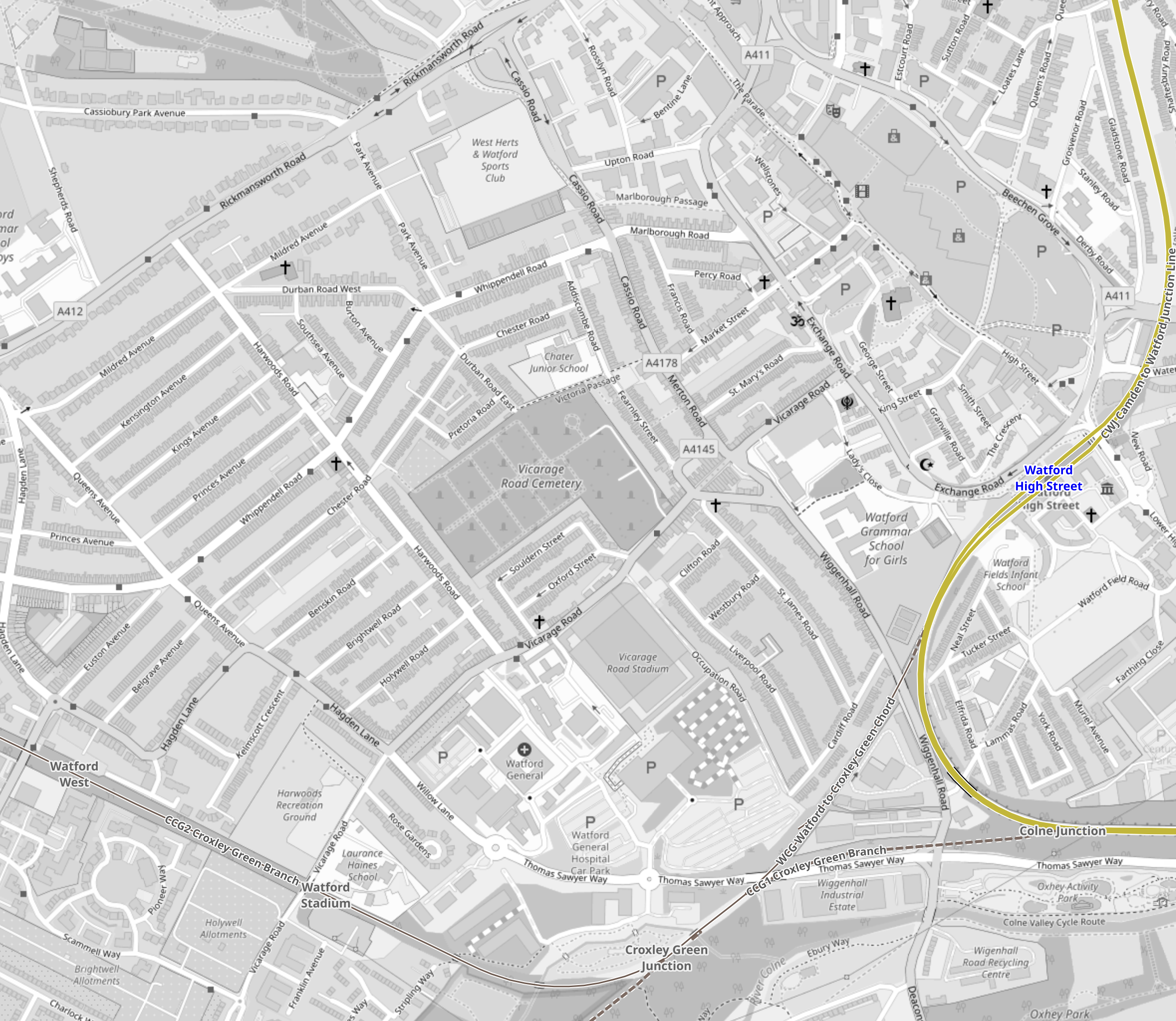
Note.
- The yellow track is the Watford DC Line, which goes through Watford High Street station.
- A disused line runs via the Croxley Green Chord to the disused stations of Croxley Green, Watford Stadium and Watford West.
- Vicarage Road and Watford General Hospital are to the North of the disused line.
The original plan for the Croxley Rail Link would have seen a double-track along the line of the old railway with stations at Vicarage Road and Watford General Hospital.
I don’t see why tram-trains could join the Watford DC Line to the South of Watford Junction station, go through Watford High Street station and then continue along the reinstated track.
The Western Section Of The Croxley Rail Link
This map from OpenRailwayMap shows the Western section of the Croxley Rail Link.
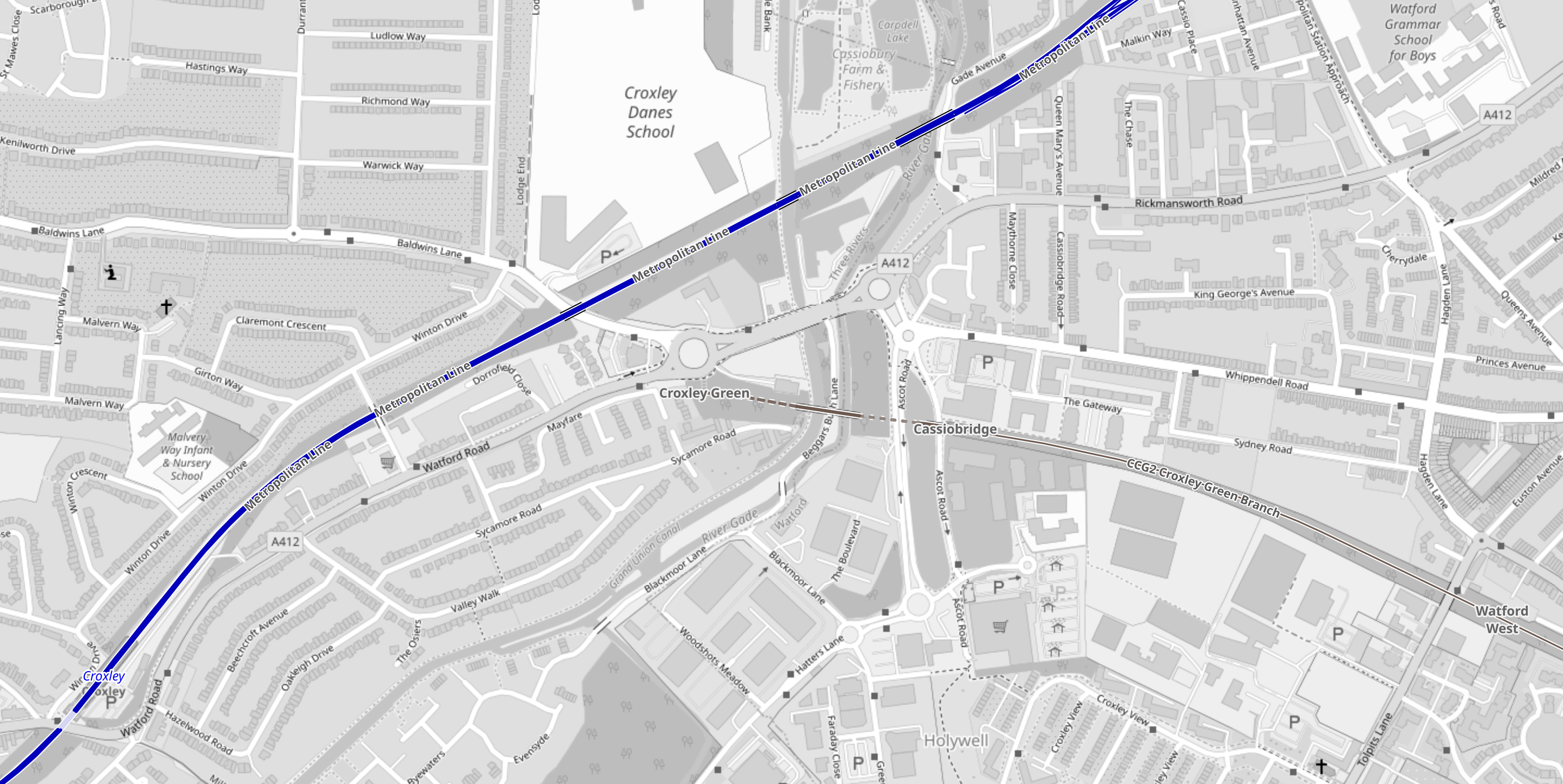
Note.
- The blue track is the Metropolitan Line, which runs to Watford station.
- The disused line runs West from the former Watford West station to the roundabout at Croxley Green on the A 412.
The original plan involved a large double-track viaduct, which is shown in this visualisation from the Watford Observer.

Note that the roundabout is the Croxley Green roundabout.
This Google Map shows the Croxley Green roundabout.
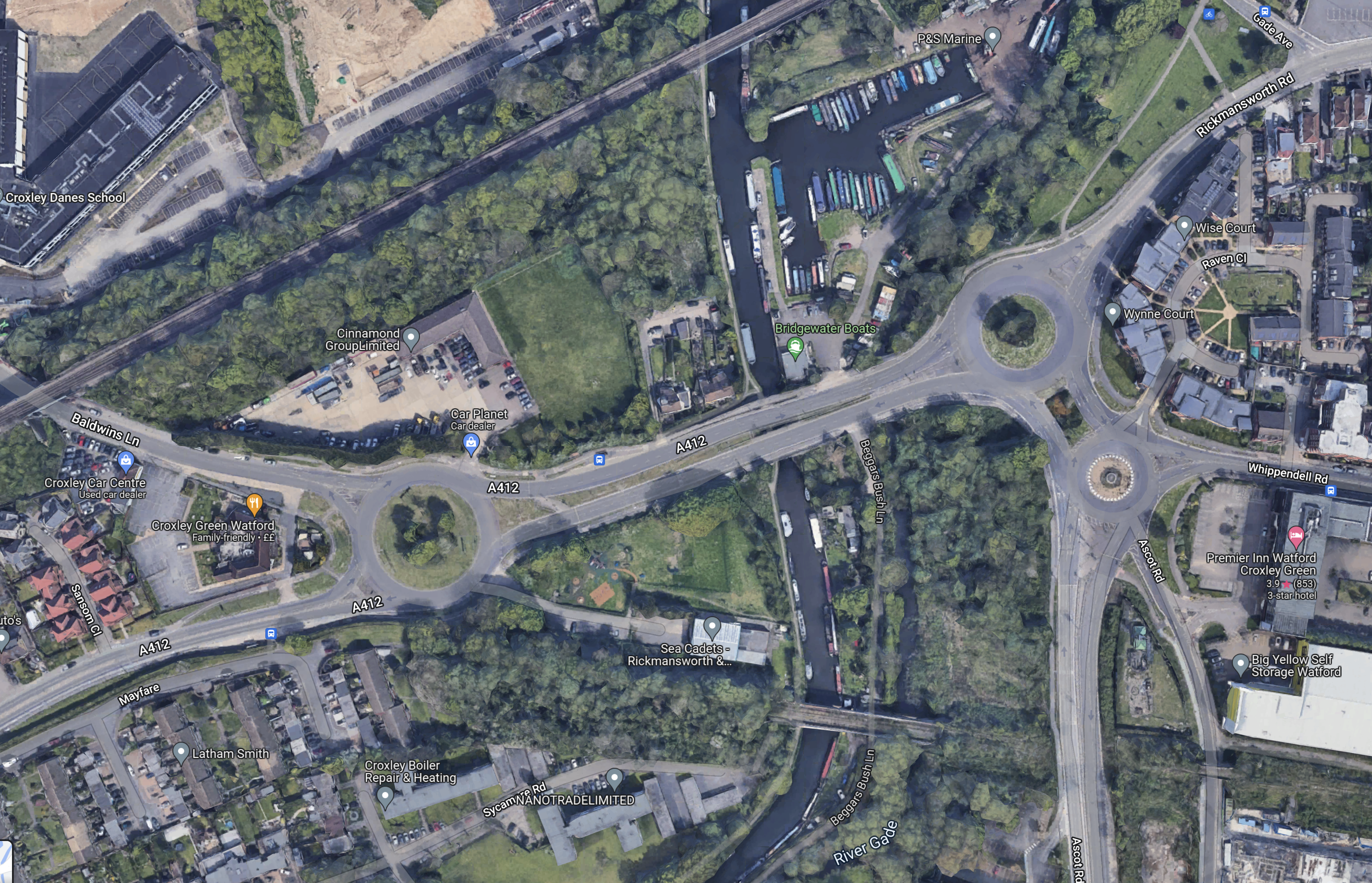
Note.
- The Metropolitan Line to Watford station runs across the North-West corner of the map.
- The Croxley Green roundabout is the roundabout in the West of the map.
- The disused railway runs from South of the roundabout to the South-East corner of the map.
- The proposed Cassiobridge station would be in the South-East corner of the map.
I wonder, if it would be possible to build a Croxley Green station to the South of the roundabout.
This would be an interim solution until it is worked out how to connect the Croxley Link to the Metropolitan Line.
Solutions could be.
- The original solution of a massive flyover, which would be very expensive and disruptive to build.
- Street-run the tram-train, which I feel are needed on the Croxley Link to Croxley station.
- Build a Croxley Green station on the Metropolitan Line to the North of the roundabout.
I think that experienced transport planners can find an acceptable solution.
Putin Burns $10m Of Gas A Day In Energy War With The West
The title of this post, is the same as that of this article in The Times.
This is the first paragraph.
Russia is burning off an estimated $10 million of natural gas a day from a single plant, leading to accusations that President Putin is deploying his country’s vast energy reserves as a weapon against Europe.
It just showed the sort of idiot we’re dealing with!
- He doesn’t care about the planet.
- He’s effectively burning his country’s cash reserves.
- He’s spurring Western engineers on, to on the one hand find ways to beat him and on the other to find ways to make our gas go further, so we don’t need to buy his bloodstained gas.
- If he thinks, that he might provoke a war with Finland, I suspect the Finns are too bright for that.
They’ll be waiting and if the Russian Army should invade, they’ll get the kicking of a lifetime, just like Stalin’s thugs did in the Winter War of 1939-1940.
I
