When Silvertown Opens, Blackwall Tolls Start Too
The title of this post, is the same as that of this article on the BBC.
This is the sub-heading.
In under a month, tolls will be introduced for drivers at the new Silvertown Tunnel and the existing Blackwall Tunnel in east London.
These four paragraphs add detail to the story.
For car drivers it will cost £8 a day in peak. These are huge changes to London’s transport network and awareness seems to be low.
The new highly controversial Silvertown Tunnel opens on 7 April.
Critics have dubbed the crossing a huge polluting white elephant that will do nothing to cut congestion and pollution with little or no business case.
Supporters say it will reduce congestion on the old, existing Blackwall Tunnel and improve resilience on the crossing that closes between 600-700 times a year. It will also provide more cross river bus routes as well as a bus that can carry bikes.
As a very experienced mathematical modeller, my gut feeling is that four new tolled lanes under the River Thames is not the solution.
These are my thoughts.
Transport for London Are Not Good Mathematical Modellers
As a non-driver, I rely heavily on the 141 bus for transport.
- It stops close to my house.
- It takes me to and from Moorgate, where I also pick up the Elizabeth Line.
- It takes me to and from Bank, where I also pick up the Central Line.
- It takes me to and from River Thames, from where I pick up the Thames Clippers.
- It takes me to and from London Bridge station, where I also pick up theThameslink.
- It takes me to and from Manor House station, where I pick up the Piccadilly Line.
- It takes me to and from Harringay Green Lanes station, where I pick up the Gospel Oak to Barking Line.
I must admit some of the reasons I like the bus route, are that it connects me to my childhood memories of WoodGreen, Southgate, Oakwood and Cockfosters.
When, I moved here, there were two North-South buses that ran within fifty metres of my house.
- The 21 bus ran between Newington Green and Lewisham.
- The 141 bus ran between Palmers Green and London Bridge station.
Then, two years ago the Elizabeth Line and the rebuilt Bank station both opened, followed a year later by an upgraded Old Street station.
These three improvements, added a lot more passengers to the North-South corridor, between London Bridge station and Newington Green roundabout.
I suspect a quality modelling of bus passengers North-South, through the city of London, would have shown, that more buses were needed on the combined 21/141 route.
So what did Sir SadIQ and Transport for London do? They rerouted the 21 bus away from the busiest section through De Beauvoir Town.
In their modelling, I suspect.
- They overestimated how many travellers used the Northern Line.
- They ignored the fact, that the Piccadilly Line doesn’t serve the City of London.
- They ignored the fact, that the Piccadilly Line doesn’t connect to the Elizabeth Line.
- They ignored the fact, that the 141 bus, is the only direct way between Palmers Green, Wood Green, Turnpike Lane and Manor House to the City of London.
- They felt De Beauvoir Town was a posh area and doesn’t need more buses, as residents can use their cars.
Halving the number of buses was a seriously bad decision.
I now have a damaged left knee due to constant standing on overcrowded buses.
It’s also got a lot worse lately due to constant bus diversions and cancellations, due to Islington’s LTNs and constant road works.
I’ve heard similar tales of bad bus planning from all over London.
So why should I trust Transport for London’s traffic modelling on the Silvertown and Blackwall Tunnels?
The Silvertown And Blackwall Tunnel Share Approach Routes
This map from the BBC article shows the layout of the two tunnels and their approach roads.
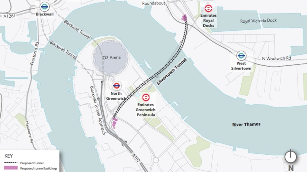
Note.
- The Blackwall Tunnel is two, two lane tunnels, one in each direction.
- The Silvertown Tunnel is one four lane tunnel, with two lanes in each direction.
- The O2 lies between the two tunnels.
The map shows the shared approach road for both tunnels.
What happens if there is an accident on the approach to the tunnels?
Tolling Problems
I feel that the tolling regime is overly complicated.
Hopefully, any problems this causes will lessen, as drivers know what to do.
The Sat-Nav Route Between The Tunnels And The M1
I’ve just looked one recommended route up, not that I have a Sat-Nav and I’ve never used one and the route is straightforward.
- Blackwall Tunnel Northern Approach to Hackney Wick.
- Wick Lane to Hackney Central.
- Graham Road and Dalston Lane to Dalston Junction
- Balls Pond Road to Southgate Road/Mildmay Park
- St. Paul’s Road to Highbury & Islington station.
- Holloway Road to Archway.
- Archway Road, Aylmer Road and Falloden Way to Henly’s Corner.
- North Circular Road and Great North Way to the M1.
I live just South of the Southgate Road/Mildmay Park junction and often these days it is jammed solid.
But there is another route from Hackney Wick.
- A12 to Redbridge Roundabout on the North Circular Road.
- North Circular Road to the M1.
I dread to see what happens, when the Dartford Crossing is closed and heavy trucks from the Channel Tunnel to the M1, decide to take the Silvertown Tunnel as an alternative route.
