The Bloomberg Building Revealed
The hoardings are now down on the Bloomberg Building.


I have read in today’s Sunday Times, that the free exhibition on the site of the Temple of Mithras and the antiquities found on the site will open on the 14th of November.
Banksy At The Barbican
These pictures show Banksy’s new art at the Barbican.


As it’s in a tunnel, that is probably owned by the City of London Corporation, I doubt it will be removed or stolen.
Is Banksy going upmarket choosing underneath the Barbican?
Between Bank And Cannon Street Station
The City of London is creating a new walking route between Bank and Cannon Street stations, along Walbrook.

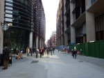

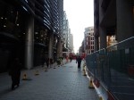
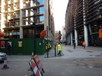
It doesn’t reach to the Thames yet, as there is some 1980s development and the dual-carriageway of Upper Thames Street in the way, but I suspect it will, at some point in the future.
On the Western side of the walk is Walbrook Square being developed by Bloomberg, which underneath which are both the London Mithraeum and the new step-free entrance to the Waterloo and City Line and Bank station.
On the Eastern side is the historic church of |St. Stephen Walbrook, where I once met Chad Varah; the founder of The Samaritans, who for personal and wider reasons, I nominated at Man of the Noughties.
This Google Map shows the area.
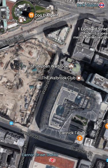
It looks like this walking and cycling route will come with a prestigious office development, an important Roman site and a transport interchange.
I have a feeling there’s a deep agenda in pedestrianising Walbrook in this way.
Commuters arriving in the City at Cannon Street station or the Waterloo and City Line will be able to come out of the stations onto the spacious thoroughfare of Walbrook , from where they could walk to their place of work. A pedestrianised Bank Junction would give a traffic free route for commuters to the East side of the junction.
Could we see other routes around Bank Junction also given over to pedestrians and cyclists? Roads like.
- Cannon |Street
- Cornhill
- Dowgate Hill
- King William Street
- Lombard Street
- Lothbury
- Old Jewry
- Prince’s Street
- St. Swithin’s Lane
and a few others, must all be being considered for full or partial pedestrianisation.
In addition, there will be beloe-ground routes through Bank station.
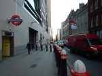
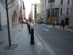
Bank Junction
These pictures show Bank Junction, at around mid-day.


Would banning of all vehicles except buses and cycles work?
The taxi-drivers think not! Thyey’ve been protesting all wek!
Bollards To Illegal Parkers
The City of London has its own distinctive way with street furniture.
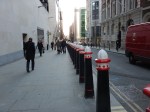
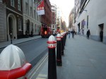

But it’s not just bollards.


A walk through the City of London is always rewarding.
Taxis And Bank Junction
The City pf London is proposing to make Bank Junction accessible to only buses and cyclists.
On a personal note, I’m in favour, as my normal route to and from the area of Bank station is to take a 21 or 141 bus. I also use the 141 bus to get to and from London Bridge station, as the terminal stop is on the staion forecourt. They are extremely convenient buses for me as the Northbound stop is perhaps fifty metres from my house over a zebra crossing. Going South, the walk is a little further, but it is no more than a hundred and fifty metres.
However, not everyone is in favour of restricting traffic at Bank Junction.
This article in the Standard is entitled Cycling campaign groups slam black cab protest over traffic ban at Bank station.
This is said.
Cycling campaign groups have slammed a taxi protest over plans to close Bank junction off to most traffic, saying drivers are supporting “the right to poison Londoners”.
Black Cab drivers brought traffic to a standstill on Monday evening as they protested plans to close off the notorious junction to all traffic apart from bikes and buses.
Union members have argued that the proposals to only allow cyclists and buses at the junction are an example of TfL dodging the problem of congestion.
So it would be cyclists on one side and black cabs on the other.
The RMT union blames Uber on their web site.
This is said in the article.
The union claims the congestion is caused by Uber cars which, in turn, leave people turning to cycling out of “desperation”.
RMT General Secretary, Mick Cash, said: “The decision to close Bank Junction to traffic is a comically inept one, made exceptionally bitter as the Mayor promised greater access to road space for black cabs.”
As I said earlier, all I want is this vital junction to run smoothly for buses.
I don’t use a taxi very often, except on say a busy, wet day to bring my shopping home, as the rank is outside Marks and Spencer, Waitrose and Sainsburys. How convenient is that?
The taxi drivers are not happy, but then London’s black cab drivers have rarely been happy in the years I’ve used them, since the 1960s.
- Getting to my house has caused a new moan, which is caused by the work that I wrote about in Why I’m In Favour Of Cycling Superhighways.
- Cyclists are always good for a moan.
- But their biggest ire is usually reserved for Uber and their lack of regulation.
Surprisingly, I’ve had no moans about moving to low-emission or electric vehicles.
So how do I think the situation will improve in the next few years?
Crossrail
Crossrail doesn’t serve Bank Junction directly, but I will be surprised if the massive double-ended Crossrail station at Liverpool Street and Moorgate, doesn’t attract a lot of passengers travelling to and from the City of London.
Bank Station Upgrade
Under Future Developments, Wikipedia says this.
- A new entrance on Walbrook, near Cannon Street station, will provide new escalators and lifts to the Waterloo and City line platforms.
- TfL is also consulting on retunnelling and widening the Northern line platforms.
- Adding lifts and new entrances on King William Street and Cannon Street.
- A new tunnel could be built to relocate the southbound Northern line platform.
The work could be completed by 2021 and will boost capacity by 40%, with 12 new escalators and 3 new lifts.
A well-designed Bank Underground station must relieve surface traffic of all types in the area.
Waterloo And City Line
When the new entry at Wallbrook to the Waterloo and City Line, opens hopefully in late 2017, it will dramatically improve the usefulness of the Waterloo and City Line.
But improvements are also needed at the Waterloo end of the line.
- Better connections to the new platforms 20-24 at Waterloo will be needed. Are they being provided in the current works.
- Better connection to Waterloo East station, so passengers can get access to Charing Cross services.
- Direct access to the street.
- Step-free access.
The line should at least run seven days a week, if not all the time under automatic control.
It could be a much more important line in London’s transport system.
It could even be renamed the City and South Bank Line.
The Northern City Line
The Northern City Line is London’s forgotten suburban line, as it terminates in a two-platform station under Moorgate station.
One of Crossrail’s collateral improvements will be to give the Northern City Line excellent connections to the following.
- Crossrail
- Liverpool Street station
- Central Line
The deep and dingy station will also have much better connection to the various walking routes in the area.
But connectivity would be nothing without trains and the Northern City Line is getting new Class 717 trains, which could run at up to twelve trains per hour all day.
The original plans for the Northern City Line envisaged the line running to Lothbury station, which would be just to the North of the Bank of England.
If this extension had been built, it would have surely proved to have been a valuable part of London’s railways. But it wasn’t and probably to build it now would be too expensive and impossible.
Walking Routes
The actual City of London is compact and this Google Map shows the Northern part of the City between Bank, Moorgate and Liverpool Street stations.
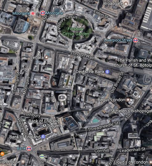
Note.
- How one of the three main stations is within reach of much of the area.
- I would reckon that the three stations are about eight hundred metres apart.
If you don’t fancy walking, there are bus routes between the stations and the Central and Northern Lines also provide connections.
Uber
Uber is the fox in the hen coup.
It is disruptive technology and I don’t like it for various reasons.
- I like to pick up my cab from a rank or by hailing it on the street.
- I feel that apps with credit card details in them will be the next big fraud opportunity.
- I like a properly trained and regulated driver, who understands the intricacies of London’s streets.
I took an Uber cab once from Walthamstow to home and the driver came from West London and managed to get lost twice. As I wasn’t paying, I didn’t bother.
I can’t help feeling that Uber is very inefficient for the driver and only works if they have a monopoly of taxis on the streets.
Conclusion
I have given alternatives to the use of taxis around Bank Junction.
Taxi drivers will protest, but that area is one, where for most people, public transport will increasingly be the best way to travel.
Could More Pedestrianisation And Better Public Transport Be A Weapon Against Terrorism?
Protecting against the sort of attack like the one in Nice last night , must be every policeman’s nightmare.
The City of London put a ring of steel around the Square Mile and there hasn’t been a serious attack since. But it caused lots of other problems.
I actually think, that we now have so many areas where large crowds congregate for work, shopping and sporting events, that we need more and more traffic restrictions like those proposed for Oxford Street.
Intriguingly, the City of London is going the same way and wants to remove a lot of traffic from the area around Bank.
So is this pedestrianisation, perhaps linked with better public transport, one of our best weapons against terrorism?
The Mind Of A Terrorist
I don’t know, as I’m at best, a poor amateur psychologist, but it strikes me there are two types of terrorist wanting to create mayhem and kill lots of people.
The first group, are those who want to leave a bomb or device and get safely away.The Bishopsgate and Baltic Exchange bombings which in today’s money together caused over a billion pounds of damage, are examples of this type, where no-one was ever prosecuted, or even publicly named.
The second group are the much-more suicide bombers, who generally strike without warning
Incidentally, I only think one Irish bomber was killed by his own bomb and we can all be thankful for that, as if suicide tactics had been employed, we would have seen many more deaths.
The City Of London’s Ring Of Steel
The City of London is protected by a so-called Ring of Steel, which is a network of barriers, check-points and 649 CCTV cameras.
It certainly seems to have protected the City from further bombings and made terrorists seek out alternative targets outside the Square Mile.
It has had one very positive effect, although at times that doesn’t seem to be as effective as it was. The City inside the ring, is now a very pleasant place to walk about and explore, as traffic is much-reduced.
Also, at weekends, the City is now a very quiet place for much of the year.
When I was still driving and needed perhaps to park a car for the evening or overnight, I would also park it prominently on a meter or legal parking space inside the ring, as I knew it would still be there in the morning.
The Future Of The City Of London
The City of London is pushing ahead with a policy of pedestrianisation, improved walking routes and better access to the Underground and rail network.
They have one great advantage compared to most other local authorities. Land is so expensive in the City and therefore fortunes are spent to create buildings that will earn billions, that if the City says to a developer, can you put an Underground entrance in your building, the answer is usually yes.
At the present time, Bloomberg are creating a new headquarters building called Walbrook Square, that will incorporate a second entrance to the Waterloo and City Line.
Other cities across the UK and the wider world are not so lucky!
Crossrail and the upgraded Thameslink will have their effects on the City, because of the positions of their stations and other factors.
- , Crossrail will have a massive double-ended station stretching from Liverpool Street in the East to Moorgate in the West.
- Thameslink will have a line of stations; Fasrringdon, City Thameslink and Blackfriars, down the West of the City.
- Crossrail and Thameslink will have their important interchange at Frarringdon.
- Crossrail will have a major interchange at Whitechapel serving the East of the City.
- Thameslink will also have a major interchange at London Bridge, just across the River from the City.
- Crossrail and Thameslink will be running two hundred metre long trains at a frequency of twenty-four trains per hour in both directions.
Add to that the existing services of the Central, Circle, District, Metropolitan and Waterloo and City Lines of the Underground and National Rail services out of Cannon Street, Fenchurch Street, Liverpool Street and Moorgate, all of which will be upgraded and I believe that at some point in the future, the City of London, will take the bold and very green step of making the whole area a pedestrian-only one, with the only vehicles allowed in the day, being approved electrical ones.
It would be a bold move, but it have several positive effects.
- Air quality would improve.
- The City would be the place to work!
- The City would become one of London’s major tourist attractions, with visitors able to walk all across from St. Pauls to the Tower and the River.
- Innovation would work to provide the services a city needed despite the restrictions.
Would terrorists realise that the sort of spectaculars they love, would be more difficult and go elsewhere?
We could see a return to suicide bombers on the Underground!
Conclusions
The City of London will reinvent itself, as it does periodically with great success.
Given that Oxford Street has said that it will pedestrianise by 2020, are we seeing a green transport revolution?
I can think of a few other cities and towns, that could follow London’s example.
Community Toilets In The City Of London
I saw this sign on the door of a pub near Liverpool Street station in the City of London.
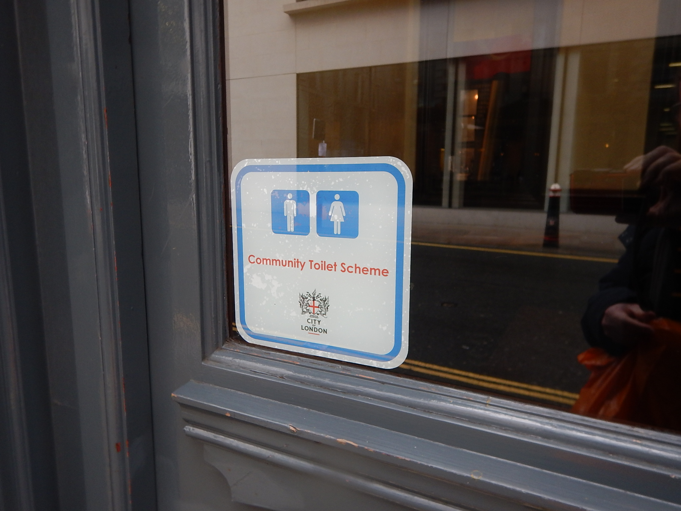
Community Toilets In The City Of London
Read more about it on this page on the City of London web site.
If you look at the page, you’ll see something rare on a web site – The author of the page is credited.
Does your council have community toilets?
The web page does say, that there is a payment from the council for providing the service.
London’s Bouncebackability
Some worry about the ability of the City of London to survive after Brexit.
I don’t and this picture gives a clue!
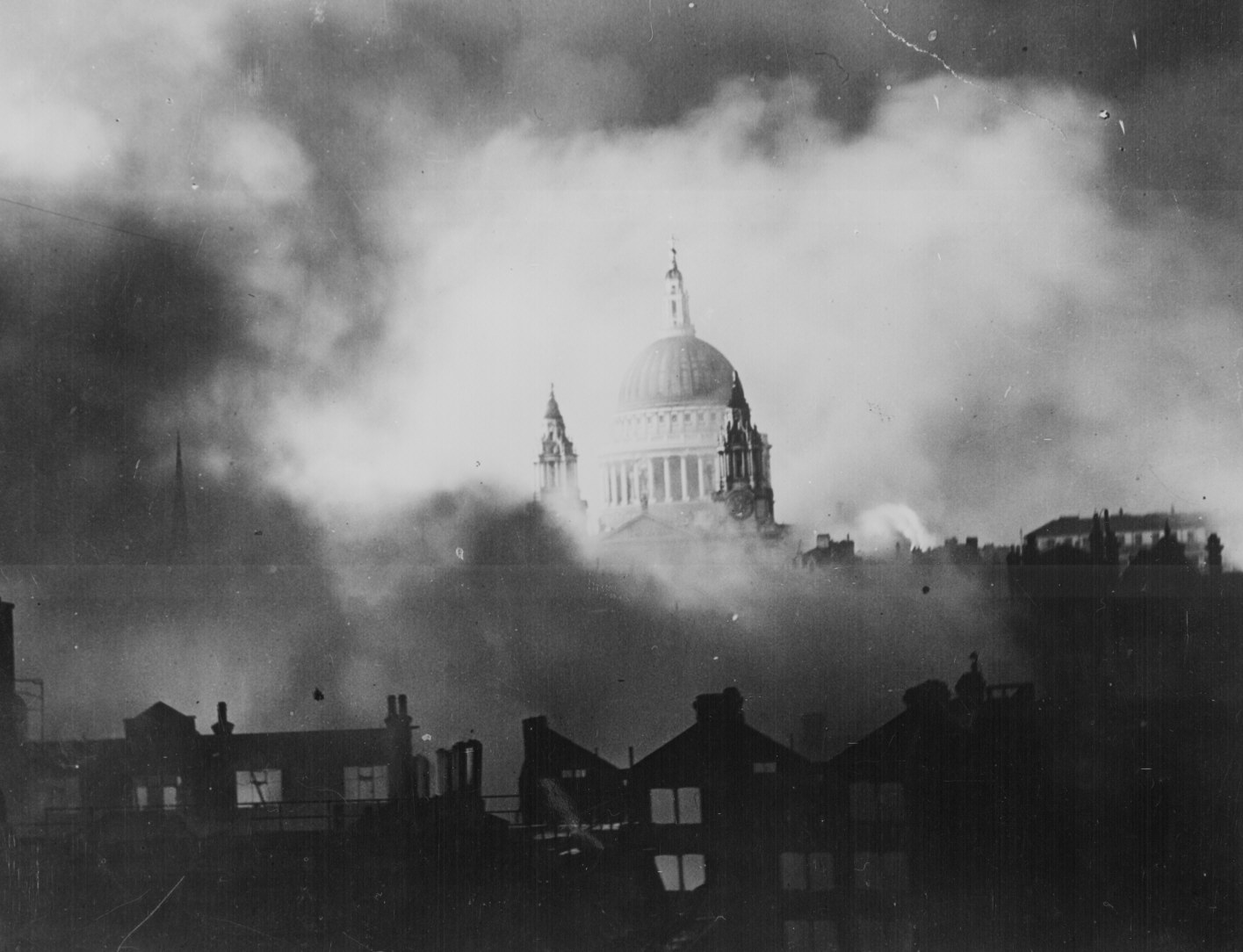
St. Pauls in the Blitz
London and the City periodically suffer disasters and annoyances.
- The Great Fire in 1666
- The Great Stink of the 1850s
- The Blitz of 1940
- The Great Smog of 1952
- The IRA Bombings in Bishopsgate and other London locations.
- The Tube Attacks of 7th July 2005
- The Financial Crisis of 2007-2008
After every one of these, London showed an impressive ability to bounce back from something that was unexpected. You coud argue that after all these events, London recovered to a higher level.
The first two, threw up two of London’s great creators; Christopher Wren and Joseph Bazalgette. Bazalgette was the grandson of a French Protestant immigrant.
Will London throw up another great creator and thinker because of Brexit?
I wouldn’t be surprised!
They might even be like Bazalgette and a descendent of a recent immigrant. London has always benefited from troubles in the rest of the world!
No-one can know what will happen to the City and its financial industry and expertise. A vindictive Europe could put in regulations to try to cut London’s market share.
But I doubt it will have much affect, as London has every expertise you could need, speaks English, is in the right time zone and quite frankly is London, where real and assimilated Londoners duck-and-dive for the best opportunity.
London will undoubtedly change, but is there any reason to suspect, that it won’t do things that make itself more successful and more powerful still?
London was the capital of the world in the Victorian Age and I can see this happening again!
Rail Lines In The City Of London Will Be Transformed
This map from carto.metro.free.fr shows the various rail lines in the City of London.
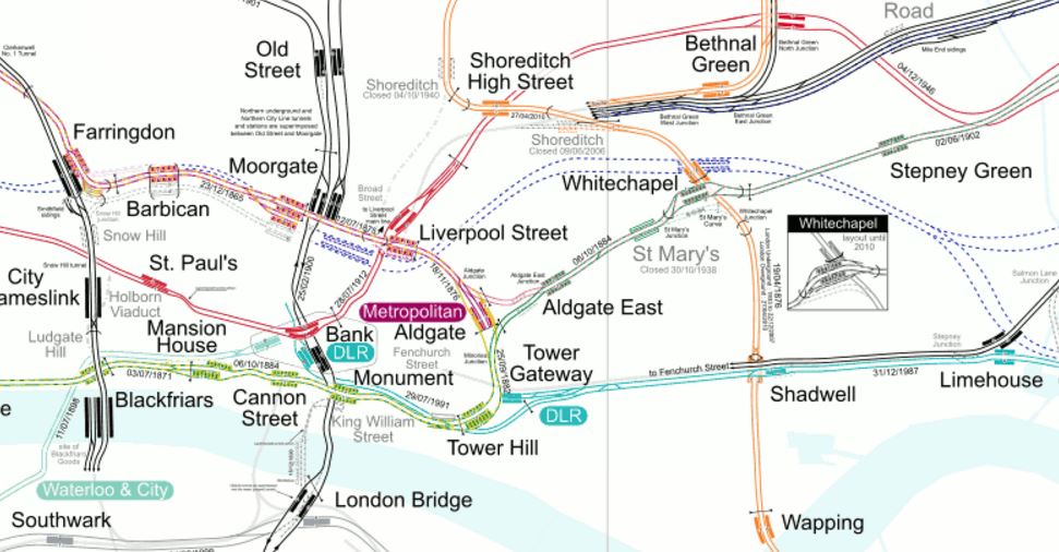
Lines In The City
Londoners and those who know the City well, will be able to pick out the lines in the map, but to help those who don’t, here’s a brief guide.
Note the North-South routes.
- Thameslink through Farringdon, City Thameslink and Blackfriars.
- Northern City Line through Old Street to terminate at Moorgate.
- Northern Line through Old Street, Moorgate, Bank and London Bridge
- East London Line through Shoreditch High Street, Whitechapel, Shadwell and Wapping.
And the East-West routes.
- Metropolitan Line through Farringdon, Barbican, Moorgate, Liverpool Street, Aldgate, Aldgate East and Whitechapel.
- Central Line through St. Paul’s, Bank, Liverpool Street and Bethnal Green.
- District Line through Blackfriars, Mansion House, Cannon Street, Monument, Tower Hill, Aldgate East and Whitechapel.
- DLR stretching east from Bank and Tower Gateway.
- Jubilee Line through Southwark and London Bridge.
There are also two lines that provide links out of the area.
- Circle Line through Farringdon, Barbican, Moorgate, Liverpool Street, Tower Hill and Blackfriars.
- Waterloo and City Line between Waterloo and Bank.
The biggest transport development London in recent years, is about to create a high-capacity link through the area.
Most people think of Crossrail, as just an east-west line across London.
Crossrail will connect Heathrow, Reading, Paddington and Bond Street in the West with Essex and Kent passing through Farringdon, Moorgate/Liverpool Street and Whitechapel.
But Crossrail will do a lot more for the City of London.
Bank
This map from carto.metro.free.fr shows the lines around Bank station.
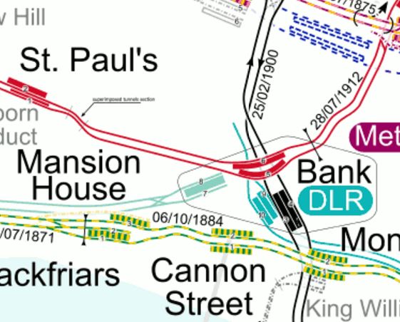
Lines Around Bank
Bank station is in desperate need of an upgrade.
In this press release on the TfL website entitled MAJOR UPGRADE OF BANK TUBE STATION GETS THE GREEN LIGHT FOR WORK TO BEGIN, this is said.
The £563m upgrade will increase the busy station’s capacity by 40 per cent, improving accessibility and reducing interchange times when it is completed in 2021. Now approved, the station becomes the latest in a series of major upgrades taking place across the Capital.
Bank is the third busiest station on the Tube network and is used by over 52 million passengers per year, with demand having risen by 50 per cent over the last 10 years. Improving the station is critical to keep London working and growing and is a key step in TfL’s future plan to increase frequency on the Northern line.
The plans for Bank station show the following.
- A new entrance to Bank station with lifts and escalators on Cannon Street at the junction of Nicholas Lane.
- This entrance will be about a hundred metres from Cannon Street station on the other side of the road.
- A new southbound running tunnel for the Northern Line, which will be to the west of the current platforms.
- Lots of cross passages and tunnels to link it all together.
The Liverpool Street/Moorgate Crossrail station, could take the pressure off Bank station during the expansion.
- As the Crossrail station, when it opens, should have good access to the Northern and Central Lines, will many walk the short distance?
- Many will use Crossrail/Thameslink to get to the Bank area, rather than a crowded Underground.
- Crossrail could be quicker to Canary Wharf from Bank than the DLR.
If the City of London took a bold step and pedestrianised much of the City, this would help make the Bank/Farringdon/Liverpool Street/Moorgate area a giant concourse for the rail lines underneath.
This Google Map shows the area from Moorgate and Liverpool Street in the North to Cannon Street and Bank in the South.

Bank To Liverpool Street
I reckon that from the Crossrail station to Bank will be about seven hundred metres of walking on the flat, as it took me less than ten minutes with plantar fasciitis.
Camberwell
Camberwell station is not in the City, but I’m including it here, as it looks like being the first positive consequence of Crossrail/Thameslink.
This press release on the Transport for London web site is entitled BAKERLOO LINE EXTENSION TO IMPROVE TRANSPORT LINKS IN SOUTH LONDON BY 2030. It says this about a new station at Camberwell.
The Mayor and TfL will be working closely with Network Rail and Southwark Council on plans for a new Thameslink station at Camberwell. This new station would reduce journey times into central London by up to 20 minutes, and by providing connections to the Underground and Crossrail, will improve access from Camberwell to locations across London.
It’s not definitely decided yet, but it looks hopeful.
I wonder if we’ll hear more before May.
This map from carto.metro.free.fr shows the lines south from Elephant and Castle.
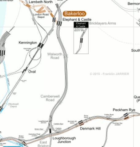
Camberwell Station
Will the new Camberwell Station be where Camberwell Road station is shown?
Cannon Street
Cannon Street station is a modern well-appointed station, but it isn’t connected directly to Crossrail or Thameslink, but all the work will benefit this station.
- The new entrance at Bank station will mean that Cannon Street will be better connected into the lines serving Bank station.
- There is also the new Walbrook Entrance To Bank Station, which opens in 2017 and will give more routes into Bank station.
- Improvements to the District and Circle Lines will mean that Cannnon Stret has better East-West connections.
- Due to the improved layout at London Bridge station, passengers will have greater flexibility in their choice of terminus.
I think that the number of passengers using Cannon Street will increase.
Farringdon
This map from carto.metro.free.fr shows the lines from Farringdon to Liverpool Street.

Farringdon To Liverpool Street
The Crossrail station at Farringdon is an immense double-ended one connecting to both Farringdon and Barbican stations.
I always think, that Crossrail and Thameslink should be treated together.
Once passengers learn how to navigate around Farringdon station, they will increasingly consider Crossrail and Thameslink as one system.
For myself, in Dalston, I suspect that my route to places South of the Thames could start at Farringdon. I could either get a 56 bus to near the station or use the East London Line and a five-minute hop on Crossrail,
Liverpool Street and Moorgate
Look closely at Liverpool Street and Moorgate on the Farringdon To Liverpool Street map and you can see the Crossrail station platforms lying between the two current stations. Several questions will be answered, when the station Crossrail station is fully revealed.
- Will connection be possible between the Northern and Central lines and easier than at the labyrinth at Bank?
- Will entrances from the Crossrail station be arranged to give direct access to the many buses?
- Will the Crossrail station create good access to Liverpool Street station from the Northern Line?
- Will access to the Northern City Line be better?
If they get the design right at the Liverpool Street/Moorgate Crossrail station, it could really take the pressure off Bank station, whilst it is extended.
London Bridge
London Bridge is a station that is being rebuilt at the moment.
It is part of this analysis, as the redesign of the station will make it easy for passengers to change easily between Thameslink and the various routes going to all over the South.
Hopefully, the new station will also make it easy to change between trains and the buses and Underground.
I sometimes think for selfish reasons, that a high-capacity surface link using a bus or tram is needed between London Bridge and Old Street, via Bank and Moorgate. I regularly use the 141 bus on this route, but it doesn’t have the required frequency or capacity.
It will be interesting to see how many passengers transfer to Thameslink, at or before London Bridge and then use Crossrail from Farringdon.
Shoreditch High Street
This map from carto.metro.free.fr shows the Central Line as it goes East from Liverpool Street to Stratford.

Central Line In East London
The Central Line is in red, with Liverpool Street station, just off the map at the left and Stratford station at the top right.
Look at the map and you’ll see that Shoreditch High Street on the East London Line is directly above one of the longer stretches of the Central Line without a station.
With all the development going on in the Shoreditch area, it could be a good idea to link the two lines here with a new Central Line station. Construction of the station would require breaking the Central Line into two halves for a couple of years, so it would be a great inconvenience.
But Crossrail connects the gap, as it serves Stratford and Liverpool Street, so it is a possibility this link will be created once Crossrail has opened.
As the London Overground stations at Bethnal Green and Cambridge Heath are very much not the best and are certainly not step-free, rebuilding them and connecting one of them to Bethnal Green tube station might be something at which to look.
This Google Map shows the rail lines between Shoreditch High Street and the two Bethnal Green stations.
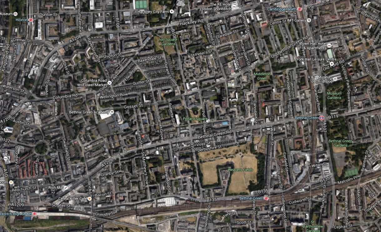
Shoreditch High Street And The Two Bethnal Green Stations
As Network Rail are thinking about some more terminal platforms in the area to ease overcrowding at Liverpool Street, we could see something innovative in this area.
Whitechapel Station
Look at Whitechapel on a tube map showing Crossrail and it appears to be just a handy interchange between Crossrail and the East London Line, and the District and Metropolitan Lines.
But it is much more than that!
- Whitechapel will be the station, where passengers going west from an Eastern branch, will walk across the platform to go back down the other branch. This will create a simple route between say Ilford and Abbey Wood stations, that avoids going further into the centre of London.
- The East London Line has a capacity of 24 trains per hour, but only runs sixteen at the moment. Once Crossrail is fully established, I believe the number of destinations on the East London Line, both North and South of the Thames, will increase.
- Whitechapel may well be the station, where travellers change to the south-east branch of Crossrail for Canary Wharf. I’ll probably do that by changing from the East London Line.
- The two platforms for the District and Metropolitan Lines will be combined into a single island platform, so on journeys like Barbican to Mansion House, passengers might take to going on a first train to Whitechapel and walking across the platform to get a district Line train, instead of waiting for a Circle Line train.
But you can’t predict how passengers will use a new station! As it’s the East End, where ducking and diving is the most popular sport, getting predictions right is even more difficult!
I shall certainly use Whitechapel station a lot, as it’s just a few stops down from Dalston Junction.
Conclusion
You ain’t seen nothing yet!
