The Hackney Downs/Central Link Is Not Small
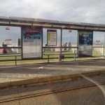
These pictures show the progress on the pedestrian link between Hackney Downs and Hackney Central stations.

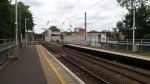
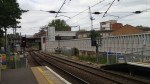
It certainly isn’t small, but once complete it will be a weatherproof way of getting between the two stations.
It should also be remembered that Hackney Downs station is not very step-free and I suspect that this walkway will only be the start of integrating these two stations to create a Hackney or Hackney Junction station. The new Tube Map for the end of May, shows the two stations connected.
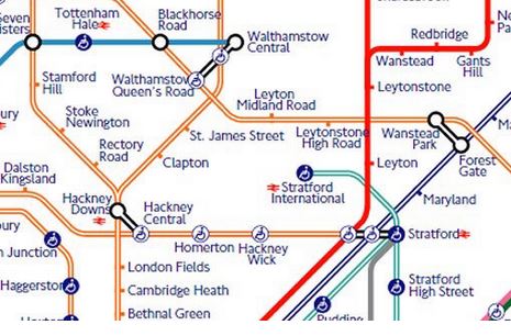
Hackney On The New Tube Map
I hope the ingenious individual who drew the new map, didn’t suffer too much mental anguish. Or did they go to Finchley Central station for divine inspiration?
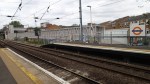
The new link between Hackney Downs and Hackney Central stations, illustrates how far steel design and construction has improved, if you compare the pictures in this post with one taken in 1928 of the original link, which was demolished in 1944, when Hackney Central station was closed.
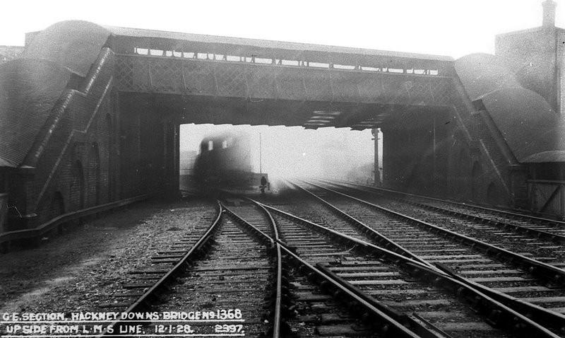
When I see terrible stations built in the last few years, like these in Kassel, with precipitous stairs and no lifts, I do wonder how architects and engineers manage to get it so bad. Perhaps they should fire the accountants and the politicians! After all, this bridge at Hackney from probably over a hundred years ago connects to both platforms at Hackney Central with a covered stairway and although it has no lifts, would probably have been considered state of the art in its time.
The West Midland’s Transport Map
I snipped this off the Network West Midlands web site.
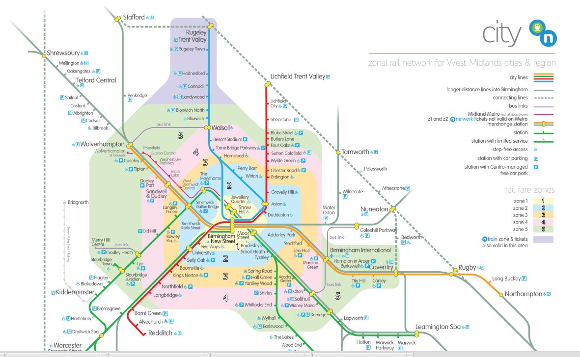
West Midlands Transport Map
Will it ever be as recognisable as the London map?
Transport for London Have A Small Problem
This year a the end of May, some of the Lea Valley Lines and the Shenfield Metro part of Crossrail come under the control of Transport for London.
But what are they going to do with the iconic Tube Map?
This reasoned article on The Londonist gives their ideas including starting again and imagining how Harry Beck would have drawn it now!
Whatever they do, millions will think it’s been done wrong.
Transport for London Drops An Interchange
I noticed this Tube map at Whitechapel station today.

Transport for London Drops An Interchange
The interchange at Embankment seems to be missing. It was certainly there when I went through the station this morning. Although for many months lately, the interchange wasn’t able to be used during escalator rebuilding.
There is a piece in Business Insider, which discusses the omission.
What would Harry Beck have thought?
Blackpool’s New Maps And Signs
I’ve criticised Blackpool in the past, as lacking maps and information. But they have at least got started on a visitor-friendly information system.


I think it is true to say, that most of the locals and visitors I talked to, said that the town had been getting better in the last couple of years.
These maps and signs should lead to fewer people getting lost.
But there were no signs pointing you to the trams at the station and the tram stops didn’t have any maps or even information about how you use the tram.
Across Manchester In The Sun
For one of the few times in my life in Manchester, it wasn’t raining, as I walked between Piccadilly and Victoria stations.


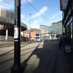

But it was still a trying walk, for someone whose eyesight isn’t the best, as it doesn’t seem to have the number of light-controlled crossings, that other cities have!
There were also no maps and only a few forlorn finger-posts.
Navigating The Docklands Light Railway
The Docklands Light Railway (DLR) or Topsy to her friends is one of London’s transport success stories, although in it’s early days a Glaswegian once called it a Disney railway. Why? “Because it disney work!”
Since its opening in the 1980s, Topsy has grown from a simple system with single-coach trains serving just fifteen stations, into the transport system that was one of the real stars of the Olympics in 2012. According to a Senior Manager at Transport for London, I met on the DLR, ridership during the Olympics on the system, outperformed all their expectations. And the system coped!
Topsy has developed a character of her own and is a friendly transport option in the area of London, East of the City to Stratford, Woolwich and Lewisham. The DLR is on the Tube Map, but it also has its own welcoming map on the platforms.

DLR Map At Shadwell Station
It could be a bit confusing to visitors, as I had to show a Frenchman how to hop to Canary Wharf, but generally it works.
The Cardiff Valley Lines, which although they are heavy rail has a surprisingly similar layout, so perhaps they should create a similar map to help visitors.
But whatever happens, long may Topsy continue to grow!
I doubt that the line will get to Dagenham Dock, although the area could be better connected to Stratford and Crossrail.
But I do think, the system could reach to Euston and St. Pancras or expand southwards from Lewisham.
Whatever happens London’s transport system will get overloaded and just as they have done a few times in the past, they’ll call again on Topsy!
A Big Lith In Cardiff
I was greeted by this large lith at Cardiff Station.

A Big Lith In Cardiff
Every main station and bus station should have one.
Why Is London’s Transport So Well Mapped?
I’ve travelled all over the UK and a lot of Europe in recent years, and as I don’t drive, I have to use public transport.
What amazes me, is how poor mapping is in most cities and towns outside London.
There are exceptions like Munich, Glasgow and surprisingly, Ipswich, but most are pretty terrible. I’ve even had a letter in The Times complaining how bad the situation is in the UK.
So why is London so much more advanced with its maps, information and wayfinding?
In the 1920s and 1930s when the Underground was going through a major expansion, they probably had a problem with passengers not knowing where they could go!
So this led to Harry Beck‘s iconic Tube map, a version of which is still use today.
In the 1950s, when I started to explore London on my own, my mother told me that if I got lost to find a Tube station, as they had a tube map to me back to Oakwood and a local street map to find what I was looking for. It is still the same today, except that the tube map is more comprehensive and the local maps are generally larger and much better.
Over the last few years London has applied the pre-war principles to the buses, with bus route or spider maps that could have been designed by Harry himself and local walking maps at every bus stop with a shelter.
And then there’s Legible London and all its liths and fingerposts. Wikipedia sums it up like this.
Unlike other wayfinding projects, Legible London leaps over bureaucratic boundaries in order to provide one consistent visual language and wayfinding system across the city. This city–wide approach was implemented to help visitors and local residents to easily gain local geographic knowledge regardless of the area they are in.
In contrast if you go to the Manchester area, Manchester uses one design and Salford another.
London is different to other UK cities and most in Europe, in that it is so much larger.
Consequently, most Londoners are regularly a visitor in their own city, when they find themselves in a part of the city they don’t know.
And of course this applies to those who manage the city, so they appreciate the problem.
If you take a city like Nottingham or Liverpool, most of the locals probably have the city in their head, so they can’t see the point of providing consistent visitor information all over the area. And if it were to be installed, many locals would see it as a waste of money.
So I believe that London’s size is the main reason its information system is so good.
But you must add the tradition started by Harry Beck! He may not be lauded as a great artist, but surely the London Tube Map is one of the greatest examples of public art of all time.
Sheffield’s Information-Free Buses And Trams
I chose the Leopold Hotel, as it was in the centre by a tram stop, which made it easy to get to and from the match at Hillsborough. It also meant that to get to the hotel from the train, I just went to the tram stop and used my Freedom Pass to go a few stops up the hill.
But when I arrived at the stop, all it had was details on the tram route. But there was no sign of any local map. As I’d spotted the hotel from the tram before it stopped, I just walked a few metres down the hill and round the corner.
I had planned to have an early supper with an old friend, at the new Carluccio’s on Ecclesall Road. He’d said I’d needed to get an eighty-something. So I walked and found this bus stop.

The World’s Most Useless Bus Stop
Note that is says “Buses Do Not Stop Here on the sign. It didn’t have any information that a visitor might like to use to get to the Ecclesall Road. There was no information and nobody around to answer my question.
I eventually walked a couple of hundred metres the other way and found a guy, who told me that any bus from a particular stop went down the Ecclesall Road. The queues incidentally at the stop was manic, mainly because the ticketing system required many to give money to the driver. As usual I had to put my Freedom Pass down and pick up a printed ticket.
And when I did get on a bus, there was no way, I could tell where I was, as it was a silent bus. Luckily, I knew roughly, where I was going and I knew there was a Waitrose on the corner of Ecclesall Road. But I still ended up walking further than I wanted.
At least I could read the name on the bus stops, but how do the visually-impaired manage?
The bus wasn’t that full for the rush hour and that helped me look out. But I still had to fight my way to the front to get out.
If ever a city needed London’s bus spider maps and cash free buses it is Sheffield. How many more passengers would they get, if the buses and trams were organised with the same objectives as London in mind?
But the worst thing about the buses, was coming back from Ecclesall Road was that the buses seemed to have stopped running.
In the end I had to pay £6 for a taxi.
How visitor-friendly is that?
At least when I need to go to Sheffield in the future, I now know that unless I’m going to somewhere near a tram stop, the best course of action will be to stay at home.
