Is The UK Developing Sea-Drones To Protect Wind Farms?
I asked Google AI the question in the title of this post and received this answer.
Yes, the UK is actively developing and utilizing sea-drones (and autonomous boats) for its offshore wind farms. This technology is being used to protect the farms by patrolling subsea infrastructure, inspecting underwater turbine foundations, and delivering heavy equipment to mitigate human risk.
Here is a look at how sea drones and autonomous systems are being developed and used for the UK’s offshore energy sector:
Subsea Security and Patrolling: The UK and NATO are highly focused on protecting critical subsea cables and wind networks from adversarial interference. Firms like Aberdeen-based Honuworx have been contracted to develop autonomous underwater vehicles capable of prolonged remote operation for defense and infrastructure surveillance.
Underwater Structure Inspection: Projects like the UNITE program (led by Heriot-Watt University and supported by the National Robotarium) are testing AI-controlled underwater robots to operate in turbulent seas and maintain offshore wind infrastructure. Meanwhile, Beam (an offshore wind services company) successfully deployed the world’s first AI-driven autonomous underwater drone at Scotland’s Seagreen wind farm, cutting inspection times in half.
Sailing Drones & Remote Operations: Energy companies like Vattenfall are controlling uncrewed surface vessels (USVs) and sailing drones from remote operation centers in Aberdeen to patrol and keep North Sea wind farms safe and efficient.
Heavy-Lift Cargo Drones: Beyond sea drones, energy giant Ørsted has utilized giant autonomous drones to deliver heavy equipment—like 70kg boxes of safety gear—directly to the tops of offshore wind turbines in the UK, removing the need for ships and cranes in rough seas
We should fight fire with innovation.
Support For Edinburgh Tram-Train Scheme
The title of this post, is the title of a third-of-a-page article in the June 2025 Edition of Modern Railways.
This is the first paragraph.
Final-Year civil engineering undergraduates at Heriot-Watt University’s Edinburgh campus have received warm support for a study in which they recommend reopening the city’s 7.5 mile South Suburban Railway, used for freight and diversions since 1962, using tram-trains.
It looks like they would start in the West at say Edinburgh Gateway or the Airport and would then turn South at Murrayfield to join the South Suburban Railway at Gorgie.
This OpenRailwayMap shows the tracks to the South of Murrayfield stadium.
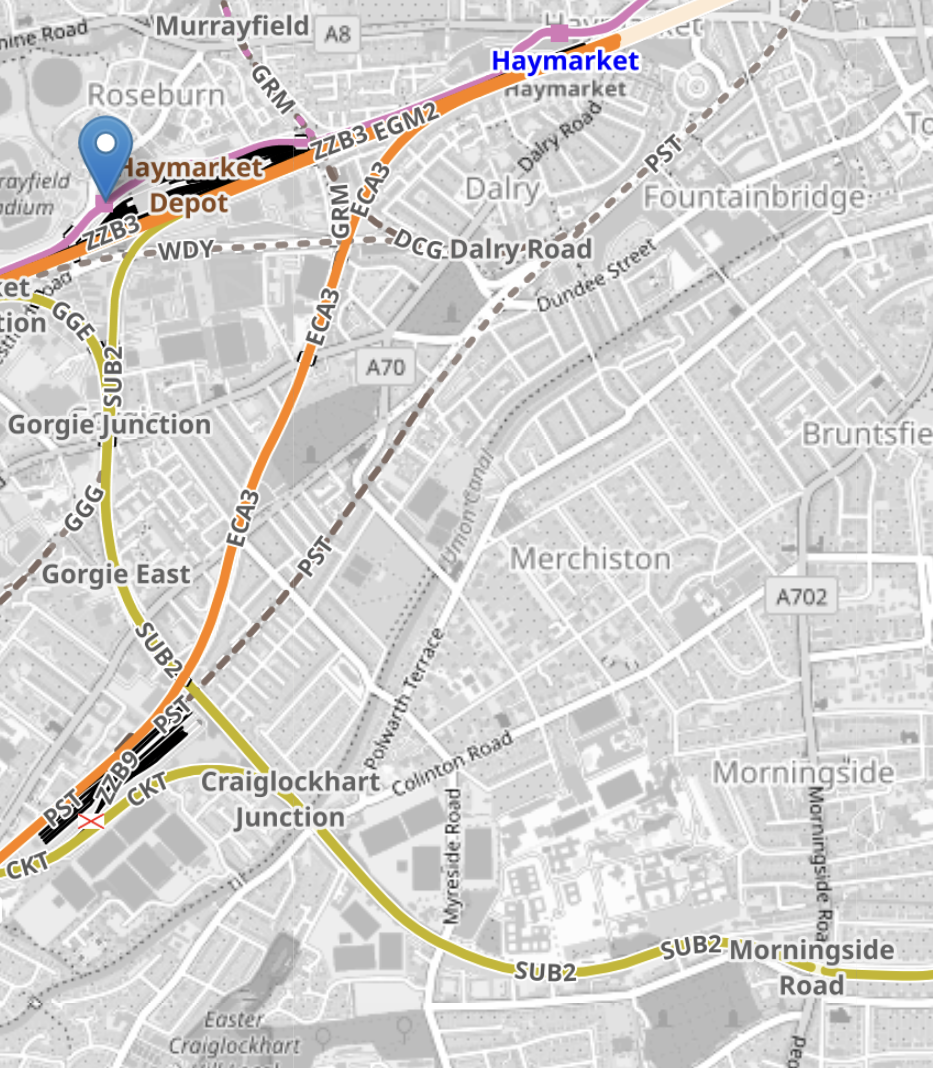
Note.
- The more Westerly-oriented orange tracks lead to Glasgow.
- The orange tracks running South-Westerly are the tracks to Carstairs.
- The yellow tracks are the South Suburban Railway.
- Tram-trains could then go all the way to Brunstane on the Borders Railway.
- The blue arrow indicates the tram-stop for Murrayfield.
- I would assume that the connection to the South Suburban Railway, is to the East of this stop.
- Gorgie East, Craiglockhart and Morningside Road were stations on the South Suburban Railway.
This map shows where the South Suburban and Borders Railways meet in a large triangular junction.
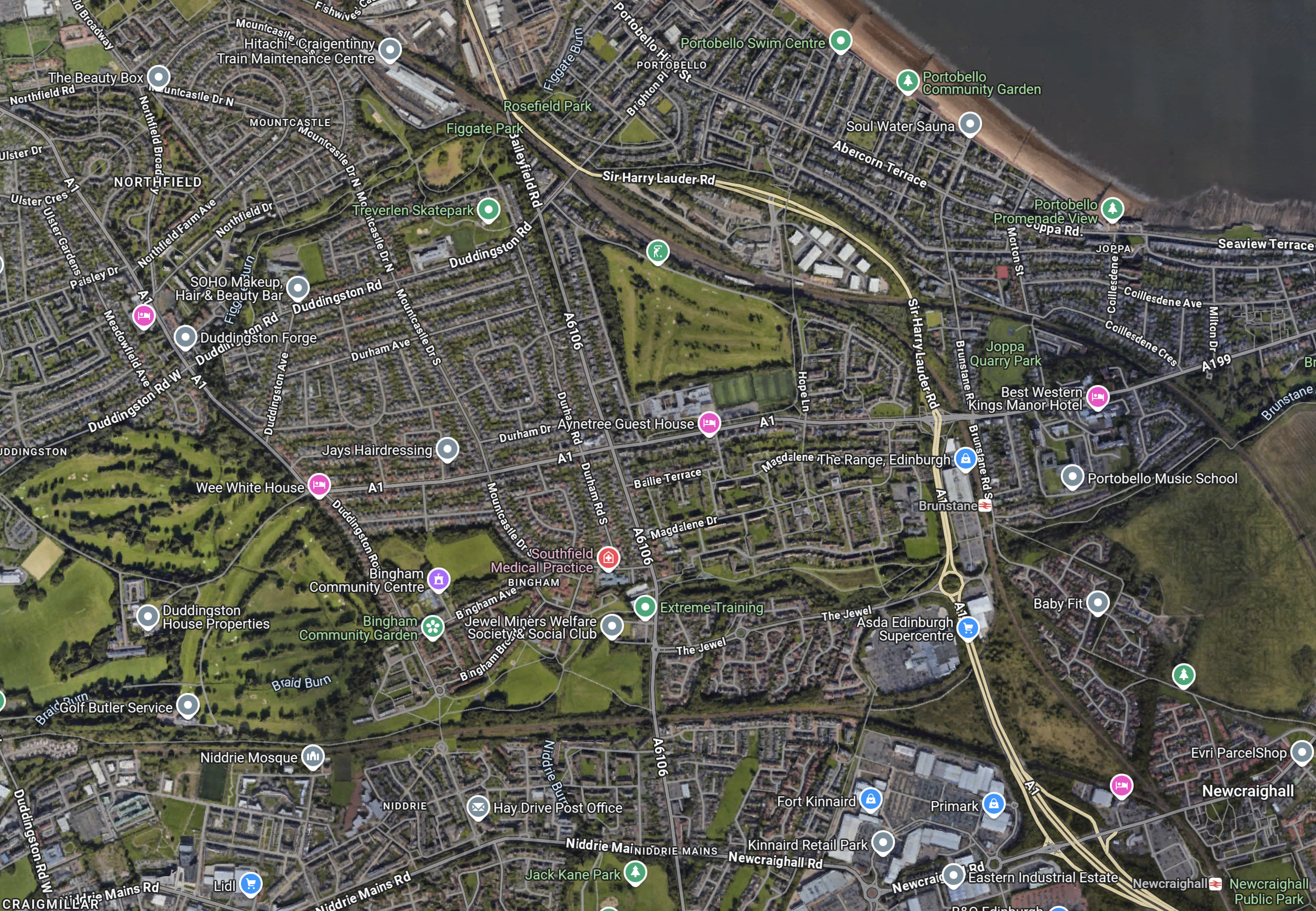
Note.
- Newcraighall station on the Borders Railway is in the South-East corner of the map.
- Brunstane station is to its North-West almost halfway up the map.
- The two stations are the North and South points of the triangular junction, where the South Suburban and Borders Railways meet.
- The South Suburban can be seen going West towards Gorgie and Murrayfield.
- Edinburgh’s beach at Portobello is in the North-East corner of the map.
- Between Murrayfield and Brunstane, there would be an appropriate number of tram stops and a tram-train every fifteen minutes.
Optionally, the route can be extended to Leith on a mothballed freight line.
This OpenRailwayMap shows the railways and tramways of Edinburgh between Brunstane, Edinburgh Waverley and Leith.
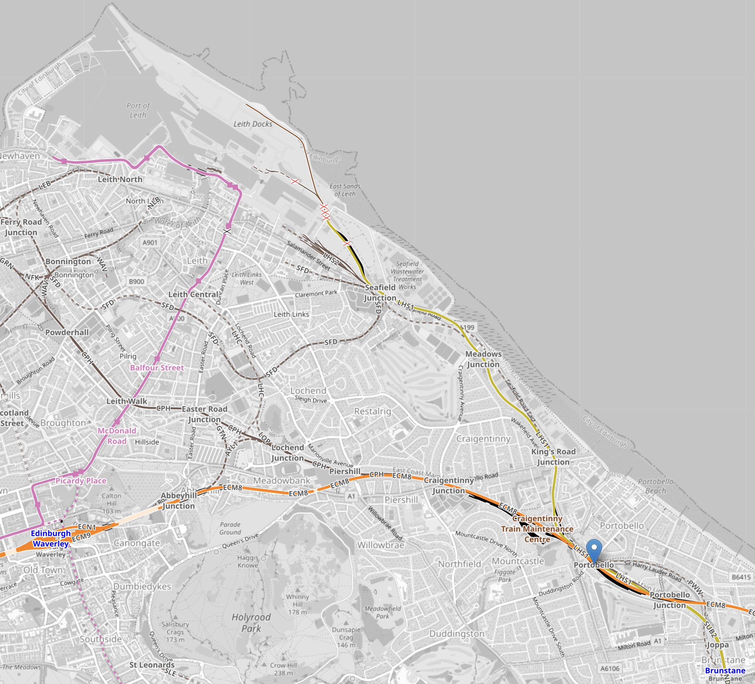
Note.
- The orange track running across the bottom of the map is the East Coast Main Line into Edinburgh Waverley station, which is clearly marked.
- The pink track is the Edinburgh tram to Newhaven.
- Brunstane station is in the South-East corner of the map.
- The site of the former Portobello station is marked by the blue arrow.
- The yellow track from Portolbello up the coast is a mothballed freight line to Leith Docks.
The proposal suggests that the tram-train route finishes at Leith Docks. One of the reasons, is that this part of Edinburgh, is not well served by public transport.
I have some extra thoughts.
Changing Between Borders Railway and the Tram-Train At Brunstane Station
Brunstane station, is a two-track station, with only one platform, so there may need to be track modifications.
Do Edinburgh’s Urbos Trams Have A Tram-Train Variant?
They do!
Do Edinburgh’s Urbos Trams Have A Battery Variant?
Battery tram-trains charged at either end of the route will be needed.
A battery-electric Urbos 3 tram, can be seen running through the City of Birmingham in England.
Conclusion
The proposal looks feasible to me. But the devil will be in the detail.
