Low Emission Buses On Hold
One of my Google Alerts has picked up this story on the London South East web site, which is entitled Torotrak Shifts Focus Following Delays In UK Low-Emission Bus Grants.
The report is on this web site, as these buses were trialled in Gillingham.
This is also said in the story.
This uncertainty, coupled with low fuel prices, has caused bus operators to postpone investing in low-emission technologies, Torotrak said. As a result, it and partner Wrightbus will delay further investment in the launch of Torotrak’s KERS technology for buses until the situation becomes clearer.
Torotrak will redeploy its cash resources on other, revenue-generating and near-term commercial opportunities in response to the delays.
Beyond this, Torotrak said its KERS off-highway technology has gained significant traction and said it has seen strong interest in its V-Charge technology from carmakers.
So what might all this mean?
Two Bus Stops On High Holborn
I went to visit one of my investments on Fetter Lane and I knew that if I could find the stop I could get a 341 bus from the area to Islington or my home.
There were two bus-stops and I knew I was on the right side of the road.

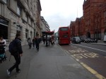
But which one do I go to? I had to walk to both of them to find the answer.
I don’t show it in the pictures, but there was a street sign between the two stops.
Wouldn’t it be nice to have a finger post to tell you where the stops are for various buses?
High Holborn is also one of those places, where there aren’t enough crossings.
Does London need a reporting system for poor street layouts or an army of elderly/disabled/teenage street walkers to collect possible simple improvements to the walking realm in the city?
Small Annoyances In Travel
I have some big things, that annoy me, but in my travels, I constantly come across small things that can be improved.
1. Beggars Selling Tissues
A complete pain and an annoyance to train companies too!
One day, an annoyed drunk, will tell one to get lost very forcibly!
2. Bi-Lingual Signs
If the Welsh want to have station signs in Welsh that’s for them to decide, but having everything in Welsh and English just clutters the station and makes doing simple things like finding toilets difficult.
3. Bus Information Outside London Is Mainly Useless
London’s bus maps and text Countdown system, sets a very high standard for bus information.
But why is it, that no area of the UK, or few in Europe for that matter, has a system that works as well for visitors?
4. Bus Pass Restriction In Other Countries Of The UK
Today, I was in Cardiff and had to buy a ticket. I had no small change, so I held everybody up and in the end a kind Welshman paid.
I believe that if all bus passes worked all over the UK, it would be a self-financing scheme, as more of us would travel to the other three countries and probably spend money which would generate VAT and other taxes.
Supposing too, we also allowed those from other countries over sixty-five or disabled to use buses for free. Would this encourage tourism and create revenue?
It certainly would be an experiment that would be worth trying.
5. Buses With Only One Door
All of London’s buses, except for the very smallest have two or more doors. It speeds loading and unloading, especially for those in wheelchairs or pushing buggies, so the buses go faster.
6. Cities And Towns With Two Disconnected Main Stations
Some cities and large towns have two main stations. Birmingham, Blackpool, Glasgow and Manchester come to mind.
If they can’t be connected by a proper rail connection, then at least there should be a ticketless way of getting between the stations.
Several times a year, I do journeys, where I have to go across Manchester between Victoria and Piccadilly stations. I have to buy a ticket on the tram, but if say I have a ticket from Euston to Burnley or Blackburn, the tram should be included.
It is not a system designed for the real needs of travellers.
7. East Croydon Station
East Croydon Station is the ideal changing point for journeys to Surrey and Sussex.
But despite the rail lines being in place, it is not easy to get there from East London. You use one of these routes.
- Bus or Bus/Tube to London Bridge station and then use Thameslink.
- Bus or Bus/Tube to Victoria station and then use a direct train.
- East London Line to West Croydon station and then a tram
The last method can’t be used coming north, as the trams don’t serve West Croydon when going west.
At present, you can take the East London Line to New Cross Gate or Norwood Junction stations and change, but this will be stopped, when the full Thameslink opens.
8. Ordsall Chord
I fear that due to the persistent opposition of one misguided and obstinate individual, that the Ordsall Chord will never be built.
9. Paddington Station
For those of us in East London, Paddington station is a very difficult station to get to. Unless you’re happy to crawl along the Hammersmith and City Line and walk a long way to your train.
10. Stations With No Information On How To Use Local Buses
Manchester Piccadilly station is particularly bad and in many cases you have to walk to Piccadilly Gardens to get the bus you need.
Some towns and cities like Sheffield have the main bus station by the train station.
If this is not possible, then at least have comprehensive information.
11, Stations Without A Marks & Spencer Simply Food
Paddington and Nottingham stations annoy me, as these two important stations don’t have a Marks & Spencer Simply Food store, which is the only one I trust for gluten-free sandwiches, snacks and ready meals.
12. Stations Without Ticket Machines
Most stations have them these days, but I’ve come across a couple recently which don’t.
They should also be as close to the platforms as possible, under a shelter from the weather.
13. Taxi Drivers That Are Incompetent
In London we’re spoilt as our black cab drivers know where they’re going and everything is on a meter.
I think because of this, all the mini-cabs seem to work to a very good standard of knowledge.
But I’ve had some very incompetent taxi drivers in parts of the UK! One was even a black cab!
14. Toilets That Need Money
I know that providing toilets is expensive and that there are other reasons to charge, but why can’t someone develop a toilet that can be entered using a contactless bank card.
15. Urban Area Ticketing
If I wasn’t old or infirm enough for my Freedom Pass, I could use any contactless bank card to pay my fare on all of London’s transport.
But why can’t I do this in places like Birmingham, Edinburgh, Glasgow, Leeds, Liverpool, Manchester and Newcastle?
Are these transport authorities worried that if passenger numbers rise like they have in London with contactless ticketing, that they couldn’t afford the extra buses, trains and trams?
Bolton Station
Bolton station was a surprise, as it is overflowing with lots of Victorian architectural details. Even if trains are a bit sparse.
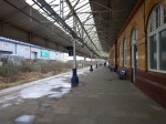


It is being linked to a new bus station and the whole will be called Bolton Interchange.
This Google Map shows the area around the station and Bolton Interchange.

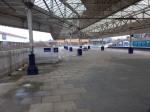
Bolton Interchange
Note how north of the station, the rail lines split with the Manchester to Preston Line going to the North West and the Ribble Valley Line going to the North.
The bus part of the interchange, is being built between the two rail lines. This is the architect’s visualisation.
Looking at the visualisation, I have a feeling that what is being created and linked to the existing station could be something of which Bolton could be proud.
All it will need is increased train services from Manchester to Blackburn, Blackpool, Clitheroe, Darwen, Preston and Wigan Wallgate.
Some or all will be electric and the others will be run by better or even new diesel trains.
I will be interested to see if Bolton’s profile in the economic scheme of things rises in the next few years.
Small-Scale Connectivity To Crossrail
I live about twenty-five minutes from my nearest Crossrail station at Moorgate on a 141 bus and as I walked around today, I just wondered what will be the best way to access London’s new East-West rail line when it opens in a few years time.
So what do I mean by small-scale connectivity?
I think it is best defined as any method that isn’t more than perhaps ten stations on heavy rail, light rail, the Underground or trams.
And of course, you might substitute Thameslink for Crossrail! Or if you don’t live in London, it could be your major cross-city line.
So in my case, the following would be small-scale connectivity to Crossrail.
- Walking
- Cycling
- Car
- Taxi
- Bus
I do have a heavy rail link to Crossrail in the form of the East London Line between Dalston Junction and Whitechapel, so that will be included as it is only a short stretch of line of four stations.
These are the methods available to me in Dalston.
Walking
For good connectivity, the walking routes around a station should be properly mapped and signposted on a physical wayfinding system, like Legible London used all over the capital.
I also think it is essential that a common format is used, along a line.
So this probably means that London will decide how walking maps and signposts at Crossrail stations in Essex and Berkshire will look.
Will that be acceptable to towns and cities, that have called in consultants to design their ideal wayfinding system?
One problem with wayfinding systems, is that in some places the locals who know the city or area well, say they don’t need the system and think it a waste of money.
You also have the problem in areas with more than one local authority, that each go their own way, rather than agree on a common system.
Remember too, that London is so large, that the average resident finds themselves regularly in an area of the city they don’t know. So Londoners on the whole are very pro-Legible London.
I feel that we need to impose the same wayfinding system all over the UK.
Cycling
Just as there should be good walking routes to a station, the cycling routes should be obvious and well-signposted.
And if bikes are provided for hire at the station, the payment system must be compatible with London’s.
Perhaps we need a nationwide bike hire system?
Car
Many people will want to drive to their local Crossrail station and park their car before they get the train.
i have a feeling that when Crossrail opens, the biggest complaint will be the lack of car parking at stations.
Taxi
For about the last three months, I’ve been suffering badly from plantar fasciitis and because of the limited mobility, it gives me at times, I now feel very strongly that every Crossrail station, should have a proper black taxi rank.
Recently Transport for London have announced that one of my local stations; Highbury and Islington, is going to have a taxi rank. I have yet to find a taxi driver who is against the idea and I believe this could be a winner for both passengers and black cab drivers.
Bus
Every London rail and tube station is a bus hub with its own spider map, which details all of the buses and their routes from the area. This is my lovcal bus spider map for Dalston.
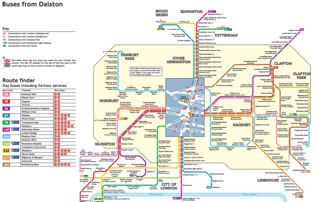
Dalston Bus Spider Map
Venture outside of London and in many places, bus mapping is often missing or very bad to give it the benefit of the doubt.
As with walking maps, local authorities outside of London with a Crossrail station, will have to adopt London’s system.
Other Rail Lines
Crossrail does connect to quite a number of heavy rail, Underground and Overground Lines.
- Bakerloo Line
- Central Line
- Circle Line
- District Line
- East London Line
- Great Eastern Main Line
- Great Western Main Line
- HS1 – After extension to Gravesend
- HS2 – After Old Oak Common
- Jubilee Line
- Metropolitan Line
- North Kent Line
- Northern Line
- Northern City Line
- North London Line
- Thameslink
- West Anglia Main Line
- West Coast Main Line – After extension to West Coast Main Line
- West London Line
I have included links to extensions to Gravesend and the West Coast Main Line and Old Oak Common in this list.
Small Branch Lines
But it also connects with several smaller branch lines or perhaps in the future, some tram and light rail lines.
- Abbey Line – After extension to West Coast Main Line
- Brentford Branch Line
- Croxley Rail Link – After extension to West Coast Main Line
- Greenford Branch Line
- Henley Branch Line
- Marlow Branch Line
- New North Main Line
- Reading to Basingstoke Line
- Romford to Upminster Line
- Shenfield to Southend Line
- Slough to Windsor and Eton Line
- Staines and West Drayton Railway
- Waterloo to Reading Line
I believe that Local Authorities will develop these smaller lines and create others to maximise their benefit from Crossrail,
A Metro In The East
The two lines that I think have the most likely chance of being developed, are the Romford to Upminster and Shenfield to Southend Lines.
- The main line rail company; c2c, is very ambitious.
- In the next couple of decades, South East Essex will be an important economic growth area.
- Better links are needed to Southend Airport and the London Gateway.
- There is substantial development of jobs, housing and leisure opportunities in the areas the lines serve.
- Give the people of Essex an opportunity and they embrace it fully.
I wouldn’t be surprised to see a substantial metro network created in the area, based on Billericay, Shenfield, Southend and Thurrock.
A Metro In The West
If a metro network can be successfully developed at the eastern end of Crossrail, is there the potential of creating something similar at the western end?
Consider.
- Heathrow dominates thinking in West London and feels that everybody should jump to its tune.
- Heathrow should wake up to the fact that it will never get a third runway, as London’s electorate will always vote to block this.
- There will always be a Heathrow, but in time, it will cease to dominate the air travel market in the UK, as it does now!
- Heathrow has very limited rail connections to Basingstoke, Reading and the West.
- If you look at the list of small branch lines, several are clustered around the western end of Crossrail, with its two hub stations of Slough and Reading.
A metro in the west could be developed based on hubs at Basingstoke, Heathrow, Slough and Reading. The Windsor Link Railway is surely thinking along those lines.
A Metro In The South East
Of all the stations on Crossrail, Abbey Wood is one of the most disappointing.
As a terminus for Crossrail, that connects to the North Kent Line and to services to South East London and the Dartford area, four platforms doesn’t seem enough, when you compare the station to the other terminals of Reading and Shenfield.
Transport for London have proposed that the Gospel Oak to Barking Line could cross the river to serve Abbey Wood and if this should happen, there must be opportunities to create another metro system based on Abbey Wood.
A Metro In The North
There are proposals to extend Crossrail to Milton Keynes from Old Oak Common.
This would surely, bring in the possibility of a network of local lines based on Watford.
- The Abbey Line is one of those difficult-to-run lines, that needs substantial improvement.
- The Croxley Rail Link could be expanded to serve Amersham.
- Local services on the West Coast Main Line and the Watford DC Line are very crowded.
This will only be developed once Crossrail serves Watford.
Conclusion
Crossrail in 2030, will be an entirely different line to that being created today.
Improving London’s Transport In Small Ways
I feel there are two ways of getting more out of London’s crowded transport system.
The first is the obvious ones of capital projects, which at the top end is Thameslink, Crossrail and Crossrail 2, and at the bottom end it is projects of the order of small numbers of millions, which might include.
- Remodelling major junctions like Archway, Elephant and Castle, Highbury Corner and Old Street.
- Reorganising bus routes around train and Underground stations, with more shelters and better information.
- New and rebuilt stations like Crystal Palace, Deptford and Lea Bridge
- Inclined lifts like that installed at Greenford.
- Step-free access at stations like Clapham Junction, Gospel Oak, Honor Oak Park, New Cross and South Tottenham.
I’m sure that new technology epitomised by the inclined lift at Greenford, will increasingly be seen.
But with any complex system, there is always improvements to be made in small ways.
The recent extension of contactless cards to Gatwick Airport, could be the sort of improvement, that increases ridership on the trains to the airport and is very much a win for the airport, the train companies and passengers alike.
We need more small improvements to London’s transport system to squeeze more capacity and improved efficiency out of the network.
1, London’s Airports And Other Places Should Have Contactless Ticketing
Heathrow, Luton and Southend Airports will join City and Gatwick in coming within London’s contactless ticketing network.
But why stop at just airports?
I feel that within a few years, the following will be within London’s contactless ticketing area.
- Chafford Hundred for the shopping at Lakeside.
- Ebbsfleet International for trains to Europe.
- Greenhithe for the shopping at Bluewater.
- Thorpe Park and other places for the fun!
- Windsor and other places for the tourists!
The benefits to residents, tourists, business and train companies won’t be small.
I suspect that as the contactless ticketing network grows, attractions and towns outside the area, will be enthusiastic to join and might even bribe Transport for London.
2. Buses Should Trial Entry Through All Doors
The bus journey I do most commonly is to get a 38 or 56 bus between my house and the Angel, where I tend to do my food shopping.
The 38 route uses New Routemasters with three doors, all of which can be used for entrance and exit, whereas on the 56 route, standard two door buses are used, where you enter through the front door and exit through the one in the middle.
There is no question that the Routemasters get through a typical stop quicker, as drivers and passengers use their brains to get on and off the bus as fast as possible. However, on the standard buses, threading a push-chair into the middle of the bus can be difficult and time consuming.
I think that an experiment should be trialled, where in perhaps areas, where there are a lot of Routemasters, passengers can board the standard buses from the middle door and touch-in on a convenient reader.
Obviously, it would be open to fraud, which is why an experiment would have to be performed first. But from several years of watching passengers on New Routemasters, I don’t think losses would be substantial. Many a time, I’ve seen passengers collectively stare at another passenger, who didn’t touch in! It’s East London peer pressure at work!
Remember too, that the doom-mongers of the left, felt cashless buses and contactless payments would be a disaster and discriminate against the poor. Try finding an incident, where someone was severely inconvenienced by London’s contactless ticketing system!
3. All Stations Should Indicate The Train Direction
On some stations this is obvious, or can be worked out, as on heavy rail routes, trains drive on the left.
But on many Underground stations, it is not obvious from which direction your train will arrive.
Often regular passengers will know that when going to a specific station, they will need to be in a particular carriage. If I am coming North to Angel on the Northern Line, I want to be in the first or second car, as this saves the effort of walking down the platform.
A simple arrow above the sdverts say, would orient you on the platform.
Hopefully, it would distribute passengers in a better manner along the platform.
4. Some Rail |And Underground Maps Could Be Larger
The standard maps are fine, but over the years, I’ve seen some really large transport maps around the world.
There’s no doubt in my mind that with maps, big is beautiful and the bigger the better.
In many stations there is a large tiled wall, for which no-one has really found a sensible use. Often you’ll come down an escalator into the bowels of an Underground station and face such a wall.
So why not put a really large map there?
It would be out of the way too and if passengers just wanted to stand in front of it and look, no-one would bother.
5. More First Train Indicators At Terminal Stations
Some terminal stations have more than one platform from which stations start their return journeys.
At Walthamstow Central on the Victoria Line, where there are two platforms, an indicator tells you, from which platform the first train will leave.
But at other stations like Stratford on the Overground, it is difficult to ascertain which will be the first train to travel west.
All terminal platforms should be fitted with First Train Indicators.
6. Better On Board Bus Information
London’s buses have a simple display, which gives a selection of the following information.
- The route and the destination.
- The name of the next stop
- Any customer information like delays, strikes or closures.
- The time.
I know the size of the display is limited, but it is poorly arranged and could be much better.
It should also show the five-number code of the next stop, so that passengers changing there could check out their next bus.
7. All Stations Should Have TfL-Standard Rail/Tube, Bus Spider And Walking Maps
When you arrive at a Transport for London (TfL) managed station, you find the following maps prominently displayed.
- The Rail and Tube version of the iconic Underground map.
- A bus spider map for all the routes serving the area.
- A comprehensive walking map.
At most TfL stations, there is increasingly a Legible London lith.
But this is not the case at some stations in London, that are managed directly by railway companies.
All stations should be made to adhere to London’s standards.
8. Below Ground Information Needs To Be Improved
Crossrail will bring some truly labyrinthine stations to London, to add to those difficult to navigate ones like Bank, Green Park, Kings Cross St. Pancras and Waterloo.
Transport for London needs to provide more bus and walking maps on the platforms and in the passageways, so that passengers can find their way to the entrance they need to continue their journey.
9. Rail And Tube Map On All London-Bound Platforms
The need for this was illustrated at Coventry station, where two tourists were asking the Virgin station-man, how to get to Ewell West from Euston. He told me, he had asked for a London Rail and Tube Map for the station, as this would have answered a large proportion of the questions he was asked.
The map could also have full details on how to use London’s contactless ticketing, which should reduce the queues at London terminals.
The only station outside London, I’ve seen such a map is Cardiff Central.
If it’s good enough for Wales, then the map should be displayed in Amsterdam, Brussels, Cologne, Lille, Marseilles and Paris.
Obviously, with information in the correct languages!
10. There Needs To Be More And Better Ticket Machines
Increasingly, I use the Internet less and less to buy tickets for travel out from London, unless it’s a longer journey and I want to reserve a seat.
I get the best Internet price from the latest ticket machines at Dalston Junction station, where I can buy the following tickets.
- Singles and returns, for today or a date in the near future between any two stations in the UK.
- Extension tickets from the Zone 6 boundary to certain stations close to London.
I get the best Internet price, without having to sign-up to be bombarded with spam by the train or ticket company.
The Zone 6 extension tickets are often a big money saver. Recently a return to Woking cost me just £5.15 with my Senior Railcard. The Standard Class Return Ticket costs £14.10, so the saving almost paid for my lunch in Woking.
These ticket machines need to be in a lot more places and not just on the Overground.
11. Ban Diesel Trains As Much As Possible From London
Despite lots of electrification on the lines into and through London, their are still quite a few noisy and smelly diesel trains to be found in London. They fall into the following categories.
- Long-distance trains like those to the West Country, Wales and Scotland.
- Freight trains on through routes, like the North London and Gospel Oak to Barking Lines.
- Commuter services using diesel multiple units.
- Engineering trains haled by diesel locomotives.
I believe that many of these can be replaced by trains hauled by quieter and greener electric traction.
Many residents of London, especially those who live on the feight routes of North London, would back this small improvement.
Conclusion
I have detailed ten small ideas, that might be used to improve London’s transport network.
I think that only the provision of more and better ticket machines will cost serious amounts of money, but from what I see as I travel around London, I suspect it’s already being done.
If I was the London Mayor, I would ask Londoners and regular travellers for simple ideas to improve the network.
Some would be bonkers, some would be so-so, but I believe that some would be brilliant.
I also believe that those good ideas, that were worthwhile implementing, should result in a reward to the proposer.
After all, London’s transport network belongs to London and Londoners, so why shouldn’t they have a say in its design?
Could IPEMU Trains Use KERS?
I have just read this article on The Business Desk, which is entitled Torotrak’s bus KERS system gets all-clear. The article starts like this.
Torotrak, a developer and supplier of emissions reduction and fuel efficiency technology in vehicles, and Wrightbus are celebrating the successful completion of the in-service trial of the Flybrid mechanical kinetic energy recovery system (KERS) for buses.
The trial was conducted with Arriva, one of the largest bus operators in the UK.
It must have been successful, as other reports say Torotrak shares have risen and the company is expected to start production of the Flybrid KERS in 2016.
I’m probably not the only engineer, who’s wondering, whether the technology can have applications with trains.
My one regret is that I only bought a thousand pounds worth of shares in the company.
Who Parked This Bus Here?
Yesterday, I needed to go between Waterloo and Victoria stations.
According to my mother’s ready reckoner that is four stations; Embankment, Westminster, St. James’s Park and Victoria and one interchange at Embankment.
So at two minutes a station and one interchange at five minutes that is a total of thirteen minutes.
But after a bit of difficulty locating a bus spider map for Waterloo, I found that I could get 507 bus direct to Victoria station, from the Cab Road, which is a very short level walk from the main station concourse.
I waited perhaps two minutes for the bus and it took fifteen minutes for the journey.
So my bus journey probably took just four minutes longer than the Underground, but there were no steps, escalators or changing trains.
The 507 bus also stopped in the forecourt of Victoria station, just a short level walk from the trains.
The forecourt at Victoria station is rather small, so why do they allow buses like these to take up valuable space?

Who Parked This Bus Here?
I think that tourist buses are an unnecessary curse on London’s traffic and they are part of a big industry that rips off visitors and puts them off the greatest city in the universe!
Hopefully, someone will write a guide and an app, which will mean that all the Routemasters can be used as tourist buses, which explore all parts of the City.
I live on the Routemaster-equipped 38 route from Victoria to the romantically-named Clapton Pond and know a lot of the interesting history you pass through from end-to-end of the route.
One decent audio-guide app, would help to consign tourist buses to the dustbin of stupid and unnecessary ideas.
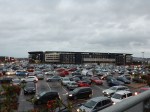
A Better Experience In Milton Keynes
Milton Keynes has never been my favourite place, since I used to take my late son; George, to his boarding school, which inevitably meant a trip round the endless roundabouts. I was then mugged in the city by the street furniture, that I wrote about in A Pedestrian-Unfriendly City.
So when Ipswich were playing MK Dons, I thought I’d give the city one more chance.


These are a few observations.
- The London Midland train was filthy and swimming in beer. I would assume it was supporters going to London.
- There is no information at Milton Keynes Central station, as to how you get to the ground.
- Bus 1 from Milton Keynes Central station, drops you just a rather cluttered short walk from Stadium MK.
- There are no signs or maps for Away supporters, as to what is the best route.
- Someone told me, that if you drive to the ground, parking costs £7 and you have to pay on-line.
- I’ve never been to a British stadium before, where burger vans and tea stalls outside the ground, were conspicuous by their absence.
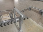
- Several of the larger restaurants outside serve gluten-free food.
- The stadium has some of the best handrails I’ve seen in a ground.
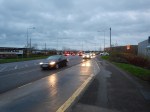
- Coming back I just missed a bus and had to wait half-an-hour for the next small but full bus in a freezing cold shelter. I’d have taken a taxi, but there was no sign of a taxi rank.
I’ve never seen a ground, where it is assumed that everyone comes by car or supporters coach before.
I would have been distinctly miserable if Ipswich hadn’t won!
Milton Keynes is going to have to improve the buses. The number one bus, that I caught links Stadiujm MK and Milton Keynes Hospital to the stations at Milton Keynes Central and Bletchley.
This Google Map shows the area of Milton Keynes.
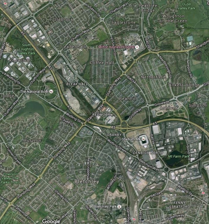
Milton Keynes Stations, Stadium MK And The Hospital
Milton Keynes Central station is in the North West corner, with Bletchley station st the bottom. The other station at the right is Fenny Stratford station on the Marston Vale Line, which will be incorporated into the East West Rail Link.
This map shows the route of the proposed line.

East West Rail Link
Wikipedia talks about extending the Marston Vale line to Milton Keynes Central, but although the track has been created, no trains have run.
Chiltern are also looking to extend their Aylesbury service to Milton Keynes Central via Bletchley, so hopefully this might prompt improvement in the bus services to Stdium MK and the Hospital.
I doubt it will, as Milton Keynes is one of those places where you’re a total loser, if you don’t have car and why should their taxes provide for better bus transport for the disabled, elderly and those that can’t drive.
I think we need a law in this country, that every hospital should have at least a four buses per hour direct service to the main railway and bus stations.
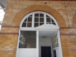
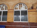
A First Glimpse Of The Planned Hackney Central Station
London Overground are planning an upgrade of Hackney Central station, as I reported in The Redevelopment Of Hackney Central Station.
I went to Hackney Central Library to get a first glimpse of the design.

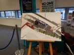


It’s certainly a big improvement on what’s there now. Some points.
- The station is to a modular design, so we’ll be seeing other similar stations.
- There is more space in the station, with the gate line turned through ninety degrees.
- The guys I met from Transport for London (TfL) were referring to the combined station as Hackney Interchange.
- TfL and Hackney Council are working together to get things right in the area.
- There is no entrance on the far side onto Graham Road, which is something I’d like to see.
- There may even be toilets.
- TfL are welcoming comments.
But TfL haven’t created the web site yet. I’ll point to it, when they do.
Improving Bus Connectivity
Like many in London, I don’t live on top of a Underground or mainline rail station. The nearest is Dalston Junction station on the Overground, which gives me good connections to mist the capital with one or more changes.
So I rely heavily on buses to get to and from stations like Angel, Highbury and Islington, Manor House and Moorgate for onward connections.
It is the same with Hackney Central and Hackney Downs stations, which could be united as Hackney Interchange.
The buses are rather chaotic around the two stations and if Hackney Council achieve their laudable aim of creating a proper public space between Hackney Central station, St. Augustine’s Tower and the Narrow Way, using the buses in the area will get more difficult.
Transport for London needs to take a good hard look at buses passing through the area of Mare Street and the proposed Hackney Interchange.
The Dalston Eastern Curve
The lack of an Eastern Curve at Dalston means that westbound passengers on the North London Line needing to go South from Dalston, must change at Canonbury.
I sometimes do this to get to Dalston Junction station, but I also take the 38 bus from Amhurst Road, after crossing the North London Line on the Hackney Central station footbridge.
In The Dalston Eastern Curve, I talked about the curve, but I don’t think it will be rebuilt in the next few years.
A Southern Entrance To Hackney Central Station
Because of its connections to the attractions at Stratford and Crossrail, I suspect that we’ll be seeing more passengers taking the North London Line to and from its Eastern terminus at Stratford station. Especially, when West Ham moves into the Olympic Stadium.
The proposed increase in size and facilities at Hackney Central will be very much needed, for all these passengers.
Many passengers though will need to go South from Hackney Central or along Graham Road, but will be frustrated in having to climb the footbridge to get out of the station on the wrong side of the line.
It is my view that a southern entrance to Hackney Central station would make travel easier for a great many travellers.
In an ideal world, a southern entrance would lead to a light-controlled crossing over Graham Road, to give easier access to the buses.
