A Station For Maltby And Other Villages
Maltby in South Yorkshire is a village of around 17,000 people, with transport links, based on buses and private cars.
This Google Map shows the village, which shares a mini-connurbation with Hellaby and Bramley, as you go West.
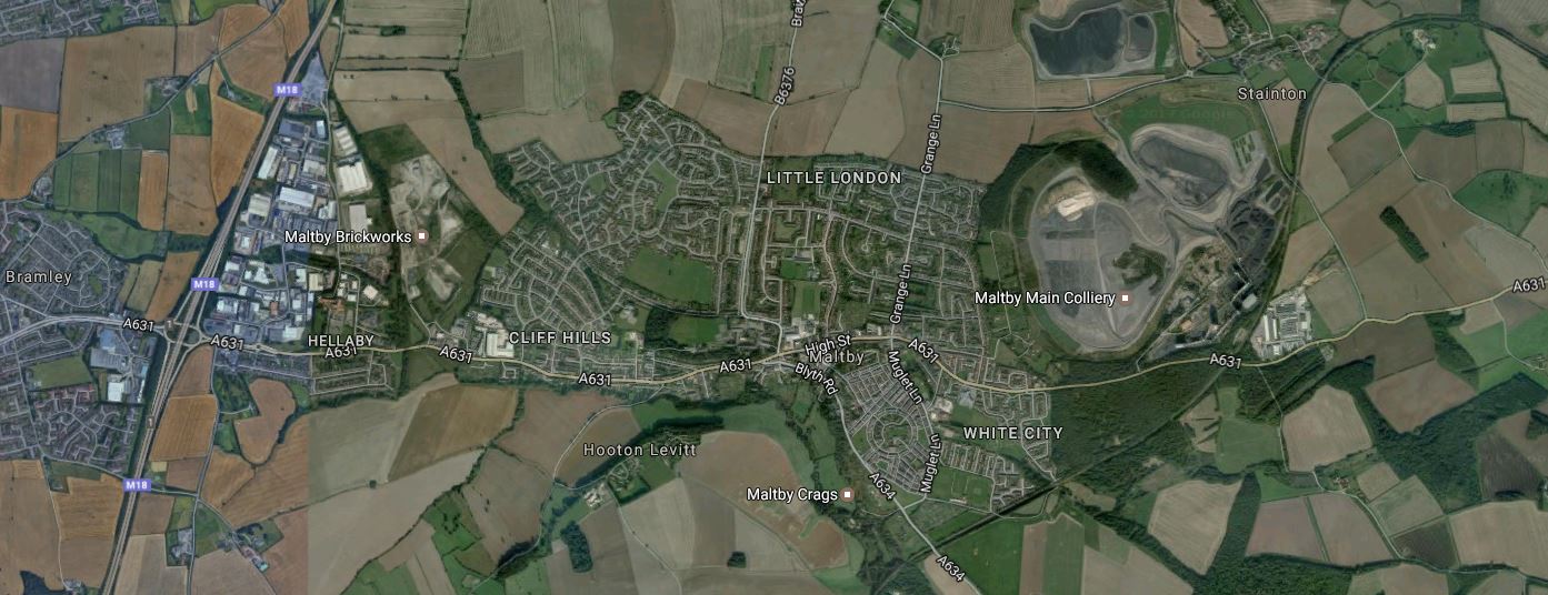
Bramley, Hellaby And Maltby
Note the massive Maltby Main Colliery, which thankfully closed in 2013. Curving round this scar on the face of Yorkshire is a railway, which starts in the North East corner and disappears South-Westerly out of the bottom of the map.
This railway is the South Yorkshire Joint Railway, which is described in this page in Grace’s Guide.
The line ran from Kirk Sandall Junction on the Great Central’s Doncaster-Cleethorpes line to a junction with the Great Central and Midland Joint Railway, just south of Dinnington. The N.E.R. had access over the G.C.R. from Hull, the M.R. had access from the Nottingham-Worksop line, over G.C.R. metals from Shireoaks, the L&Y joined at St. Catherine’s Junction from their Dearne Valley Railway and the G.N.R. had connections to the south of Doncaster. As opened the S.Y.J.R. was 21.25 miles (34km) in length, including its colliery branch lines and connections to the several lines it crossed in its path. It opened to freight on 1 January 1909, and to passengers on 1 December 1910.
Wikipedia says this about services on the line.
Passenger trains on the line ended in 1929; freight work continued on the line, with eight collieries served at peak. Most of the collieries closed by the 1990s; as of 2011, the line remains an important freight line for coal transportation both north and southwards to the Trent and Aire Valley power stations.
So now that coal is virtually in the dustbin of history, except in Trummkopf’s mind, perhaps it is time to do something positive with this railway.
The route between Doncaster and the Sheffield-Lincoln Line would appear to have the following characteristics.
- It is single-track and looks intact.
- There is no trace of any station.
- The line passes through several large villages including Anston and Dinnington.
- The line passes through the town of Doncaster and even goes close to the racecourse.
- The Northern end joins the South Humberside Main Line just to the West of Hatfield and Stainforth station.
- The Southern end joins the Sheffield-Lincoln Line at a partially-closed triangular junction between Kiveton Park and Shireoaks stations.
But the biggest factor in developing the line is that the South Yorkshire Joint Railway goes straight through the site of the proposed Doncaster Inland Port or Doncaster iPort. This is Wikipedia’s introduction for the iPort.
Doncaster iPort or Doncaster Inland Port is an intermodal rail terminal; a Strategic Rail Freight Interchange,[note 1] under construction west of Rossington and south of Doncaster at junction 3 of the M18 motorway in England. It is to be connected to the rail network via the line of the former South Yorkshire Joint Railway, and from an extension of the former Rossington Colliery branch from the East Coast Main Line.
The development includes a 171 hectares (420 acres) intermodal rail terminal to be built on green belt land, of which over 50 hectares (120 acres) was to be developed into warehousing, making it the largest rail terminal in Yorkshire; the development also included over 150 hectares (370 acres) of countryside, the majority of which was to remain in agricultural use, with other parts used for landscaping, and habitat creation as part of environment mitigation measures.
This Google Map shows the location of the Doncaster iPort.
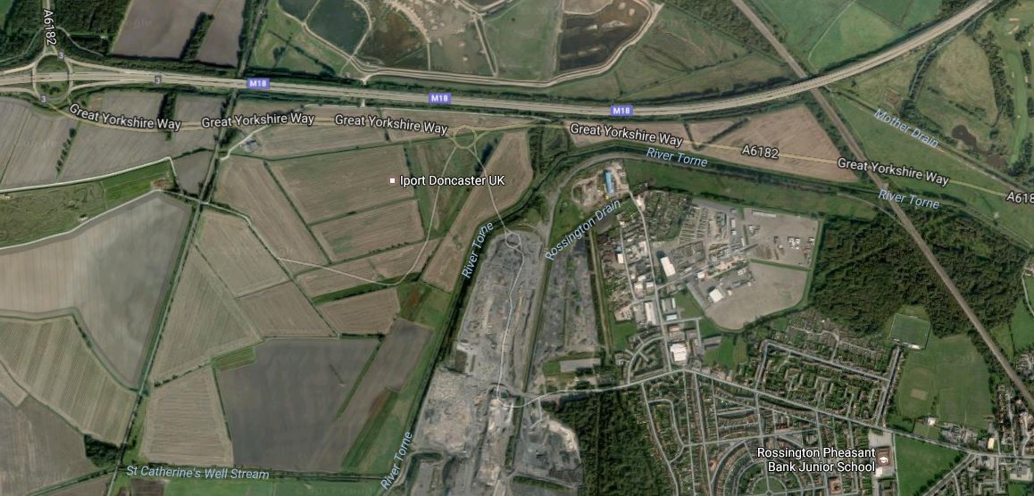
Note.
- Junction 3 of the M18 in the North-West corner of the map.
- The South Yorkshire Joint Railway crossing the site from North to South.
- The under-construction A6182 or Great Yorkshire Way, which is described in this news article on the BBC, with a headline of New £56m Robin Hood Airport to M18 link road opens.
- The scar of Rossington colliery, to the North of the village of Rossington.
- The East Coast Main Line to the East of the village.
The only thing that missing is a way to get large container ships to the iPort. Air freight will be sorted, as I wrote in A Station At Doncaster Sheffield Airport, with a choice of road or rail links between the iPort and Doncaster Sheffield Airport.
Some questions come to mind.
- Will the Rossington Colliery Branch, when extended to the iPort have a junction with the East Coast Main Line that enables traffic to arrive at and leave from the iPort in both directions?
- Will the Rossington Branch have a connection to the Joint Railway to give a route for passenger trains between Doncaster and the Joint Railway?
- How will freight trains get from the iPort to the Great Northern Great Eastern Joint Line to go South for Felixstowe?
But it does seem that Maltby and all those villages will be getting a busy railway through their midst.
It would surely be sensible to add in a few passenger services, that connect Maltby and all the other villages to perhaps Doncaster, Sheffield and Worksop.
.
A Reopened Levenmouth Rail Link
This article in Global Rail News has a title a title of Levenmouth – Scotland’s next railway?.
According to the article, the figures look good, for the reopening of the Levenouth Rail Link, with a Benefit Cost Ration of 1.3, which compares well with a figure of 0.96 for the successful Borders Railway.
It would be a five mile extension from the Fife Circle Line and would serve a station at Leven and a large Disgeo distillery.
The Robin Hood Line In Nottingham
This Google Map shows the Southern end of the Robin Hood Line as it connects to Nottingham station.
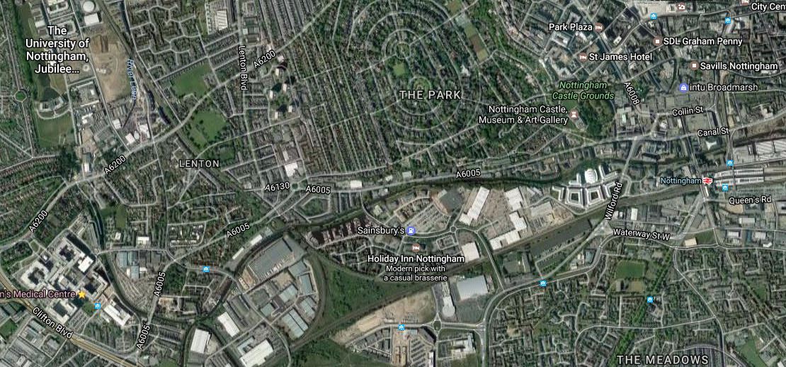
Note the triangular junction towards the bottom of the map.
- The line to the East goes into Nottingham station.
- The line to the West goes to Beeston and eventually to London. In a few years time, it will go to the East Midland Hub station for HS2.
- The line to the North is the Robin Hood Line and the Erewash Valley Line.
The \Erewash Valley Line splits to the West, from the Robin Hood Line just off the top of the map to the North of Nottingham University’s Jubilee Campus.
It is worth looking at services that go between these two branches and Nottingham station.
Langley Mill station on the Erewash Valley Line has the following services.
- One train per hour (tph) between Nottingham and Leeds.
- A few trains per day between Liverpool and Nottingham.
- Some trains between Sheffield and London stop.
Passengers though are expected to take the infrequent service to Nottingham for onward trains.
On the 2nd of April, Ilkeston station will open on the Erewash Valley Line between Nottingham and Langley Mill.
Hucknall station on the Robin Hood Line has two hourly services.
- Between Nottingham and Mansfield Woodhouse
- Between Nottingham and Worksop.
Plans also exist for a branch to Ollerton, so this might change the service pattern. But there is no more than a total of four or five trains per hour in both directions.
All of these services go round the North-East chord of the junction and thus connect Nottingham University’s Jubilee Campus and Nottingham station
But there are no stations along this line, although there used to be one at Radford.
In A Look At New Station Projects, I came across references to stations at Faraday Road and Lenton.
Both locations are on this section of line and it would seem logical that the more Northerly location would be ideal to serve the Jubilee Campus.
If only the local trains stopped, it would have the following services.
- 1-2 tph to Ilkeston, Langley Mill and Alfreton
- 2 tph to Hucknall, Kirkby-in-Ashfield and Mansfield
- 3-4 tph to Nottingham.
Other questions and issues are raised.
- Would a second station to the South nearer to the triangular junction be worthwhile?
- Could the Nottingham Express Transit. have an interchange with the trains the Robin Hood Line?
- Could the Nottingham Express Transit call both campuses of the University of Nottingham?
- In future could 1-2 tph go to the HS2 station at East Midland Hub?
It does appear that there is scope for improving connectivity in the Western Part of the City Centre.
A Station For Leiston
The Aldeburgh Branch Line is still intact, as far as Sizewell nuclear power station.
Past Sizewell, it would appear that the original route and track-bed is not obstructed and can be seen on the Google Maps all the way to Aldeburgh.
This Google Map shows the route, where it enters Aldeburgh.
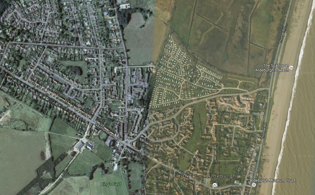
The prominent road that runs diagonally across the map in a North-West/South-East direction is Saxmundham Road and it goes all the way to the sea.
Reaching to this road is the dark scar of the railway, which runs parallel to the coast. Aldeburgh station was somewhere, where the two features meet.
Sizewell C
If Sizewell C is built, then I could envisage sets of circumstances, which meant that the line was reopened to passengers, at least as far as Leiston station.
Providing a service on the line to Ipswich would not be a problem, once Ipswich station had been rebuilt with a new platform 0 and an extended platform 1, which I believe is necessary to provide better services to Lowestoft and Felixstowe.
But whether the service would generate sufficient traffic to be viable and profitable in the long term, would be very much open to doubt.
Doubling Frequency From Ipswich To Saxmundham
If we assume that the main East Suffolk Line has a one train per hour (tph) service between Ipswich and Lowestoft, I wonder if an Ipswich to Aldeburgh Branch Line service could be used to double the frequency at the Southern end of the East Suffolk Line.
Ipswich to Saxmundham currently takes thirty seven minutes., so on a crude estimate, Ipswich to Aldeburgh could certainly be done within the hour.
I suspect that this would mean that it would not be difficult to run the Aldeburgh Branch Line trains on a one tph basis to fit in between the Ipswich-Lowestoft trains.
As at least one platform would need to be built somewhere on the single-track branch to reverse the trains, it could be built at Leiston, Thorpeness or Aldeburgh provided the track went that far.
So by reinstating the Aldeburgh Branch Line and giving it an hourly service from Ipswich would also give Saxmundham to Ipswich a 2 tph service.
Leiston Station
This increase of frequency at the Southern end of the East Suffolk Line and the needs of any future nuclear power station at Sizewell, will be the only possible reasons that passenger services will resume on the Aldeburgh Branch Line.
If trains ventured onto the Aldeburgh Branch Line, surely they would call at Leiston station.
A Modern Branch Line For Leigh
There is a group called the Lowton East Neighbourhood Development Forum or LENDF, who are proposing to reinstate part of the Bolton and Leigh Railway, to create a branch line to from a reopened Kenyon Junction station on the electrified Liverpool and Manchester Railway to a reopened Leigh station.
This Google Map shows the Southern part of the route, where it connects to the Liverpool and Manchester Railway at the former Kenyon Junction station.
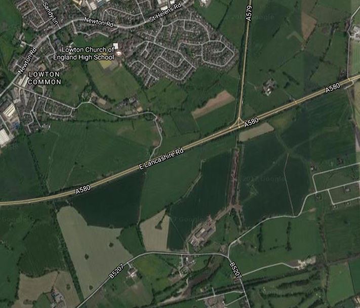
Note.
- The scar of the Bolton and Leigh Railway is clearly visible in line with the A579, which was built alongside the railway North of the A580.
- The Kenyon Junction station site can also be spotted and was recently used as a work site for the electrification of the line.
There is certainly enough space on the former station site to create a two platform station, with perhaps a bay platform to handle a shuttle train to Leigh.
This Google Map shows, where the line goes at the Northern end.
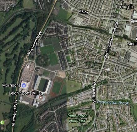
I would think that Amberleigh Way follows the route of the Bolton and Leigh Railway.
One major factor defines how far the line could go.
It would probably be prudent to restrict the length, so that the chosen train could do a round trip in under thirty minutes, thus giving a two trains per hour (tph) service with just one train and no passing loops or complicated operation.
Four tph would probably require two trains, a passing loop and some clever train scheduling.
And then you mustn’t blow the budget!
Building The Line
I would build the line as simply as possible.
- Single-track.
- Single-platform tram-style stations with no footbridges, as at say Galashiels station.
- Step-free access to the train.
- No electrification.
- No passing loop, as not needed with one train and 2 tph.
- One set of points to connect the branch to the main line for rolling stock transfer.
Kenyon Junction station would be more complicated, as it would need.
- Two long platforms for Liverpool and Manchester trains.
- A bay platform for the Leigh branch.
- A footbridge and other necessary facilities.
- Appropriate car parking.
Kenyon Junction station would be the most expensive part of the project.
Train Operation
Train operation would be under rules called One Train Working, bur probably also applying the sort of rules under which trams work.
- Lower speed.
- Warning systems
- Very visible trains
- Driver keeping a good look-out.
This picture shows a two-car diesel multiple unit working under similar rules at its terminus in the centre of the German town of Zwickau.
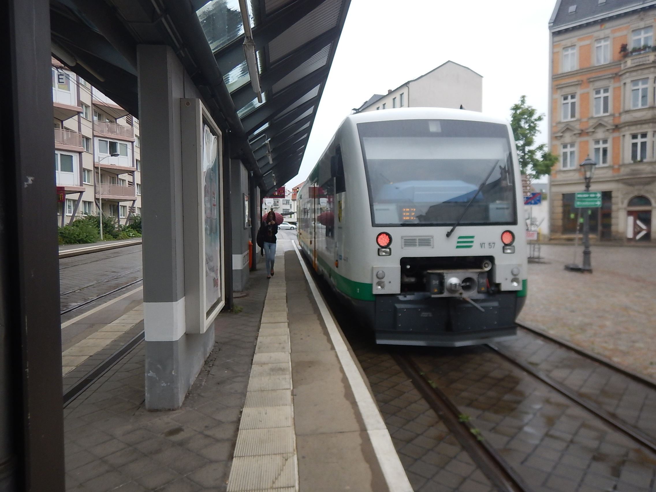
Note these points about the train and the infrastructure in the Zwickau Zentrum terminus of the Vogtlandbahn
- The train is more-or-less standard.
- The good driver visibility.
- The orange warning lights.
- The track laid like a tram track into the street.
- No electrification.
- The tram-style stop, designed to fit the trains using it.
- Pedestrians and cyclists cross the track in designated places after a good visual check for a train.
As this train goes about a hundred kilometres from this terminus, it still has visible couplings and other railway paraphernalia. These could probably be faired-in for safety and only exposed for recovery of a failed train.
Wikipedia calls this type of operation the Zwickau model, but I prefer to think of it as train-tram, as the train works as a train and then reverts to tram operation on the streets or perhaps through somewhere like parkland or moorland.
Note that in Zwickau, although the trains and the local trams have different gauges, they share tracks, using a unique three-rail track.
As there are no trams in Leigh and if they were, they would be the same gauge as the train, this is not a problem in Lancashire.
The Train
Any suitable and available self-powered train could be used.
- A diesel multiple unit like a Class 172 train.
- A fully developed Class 230 train
- A simple bi-mode train like a Class 319 Flex train.
- A train with onboard storage, perhaps charging using electrification in the bay platform at Kenyou Junction.
- One of Merseyrail’s new Stadler trains fitted with a pantograph and onboard energy storage.
I always think, that the train should be a quality unit to attract passengers.
Whatever train is chosen, the bay platform at Kenyon Junction station and all the other platforms on the branch must be sized to fit the train to ensure level access.
Conclusion
It is certainly possible to create a 2 tph service for this new branch line at an affordable cost using a standard train, working to the same rules as the Vogtlandbahn in Zwickau.
A Station At Leicester Forest East
Leicester Forest East is known to most, as a services on the M1, but as this Google Map shows, it is more than that.

Note the Park-and-Ride site at Meynell’s Gorse.
The Leicester and Burton-on-Trent Line runs past the North of the site.
Two Options For East Leeds Parkway Station
The proposed East Leeds Parkway station is a little bit more than your average parkway station.
The Wikipedia entry starts like this.
It will be served by trains from the west of Leeds which would normally terminate at Leeds station; by continuing eastwards to this station, it is hoped that extra capacity for through trains would be created at Leeds. The station would also form the first phase of electrifying the railway line to the east of Leeds. As a parkway station, the intention would be to allow for a park-and-ride service and the plans include parking for 500 cars.
It also adds these points about the station.
- The station will be on the Selby Line.
- It will have two long platforms for Inter City trains and a bay platform for terminating services.
- Proposed Ilkley/Bradford to London services could stop at the station.
- Most importantly, the Local Authorities seem to be prepared to back the station with funds.
Wikipedia also says there are two possible locations for the station.
This Google Map shows East Leeds.

Note the string of stations on the Selby Line running from West to East.
The original location was to put the parkway station at Micklefield, which is in the East, where the line crosses the A1M close to Micklefield station.
Newer plans suggest that the station should be in the region of Thorpe Park, which is close to the major interchange, to the west of where the Selby Line crosses the M1.
I suspect both locations have their merits, but that the Thorpe Park location may have a lot more space and a convenient brownfield site, as this Google Map shows.

The Selby Line runs from West to East at the top of the map.
The site is cetainly well-served by the roads in the area.
A Station For Leeds/Bradford Airport
When I wrote The Glasgow Airport Rail Link Will Be A Tram-Train, I put in a section about the rail link to Leeds/Bradford Airport.
I had just read this article on the BBC is entitled Leeds Bradford Airport railway station one of three planned.
This is said.
The proposed new station about one mile (1.6km) from the airport would also act as a park and ride for commuters to Leeds and Harrogate.
I wonder if the trains at Leeds/Bradford Airport will go the last mile?
Even if the link is not electrified, why can’t we imitate the train/trams in Zwickau, that I wrote about in Riding The Vogtlandbahn.
A diesel multiple unit like a Class 172 train, refurbished for Airport and Park-and-Ride duties could leave the Harrogate Line at the Park-and-Ride and then proceed under tram rules on a dedicated track to a tram-like station at the Airport.
The needed infrastructure would be simple, with no electrification and stations built like the simple affairs on the London Tramlink, with no bridges.
Why not?
Obviously, the ideal solution would be to electrify the Harrogate Line and have trains run into the airport using onboard energy storage.
My only worry about the concept is that of an Airport Link doubling as a Park-and-Ride.
It would need careful capacity planning and be designed so that more frequent and longer trains could be accommodated if the need for more capacity arose.
After all, we don’t know if Yorkshire will vote to exit England!
A Nation Of Shopkeepers
The phrase a nation of shopkeepers, has often been said about the British or the English in a derogatory manner by the French and others.
The Fort Kinnaird Retail Park in Edinburgh is according to Wikipedia, the second largest in the UK.
This Google Map shows the layout of Fort Kinnaird.
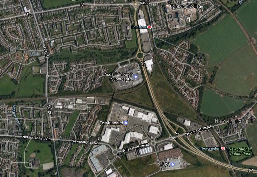
Note the two Borders Railway stations of Brunstane and Newcraighall to the East of the Park, where lines lead to to Waverley station and the Borders .respectively.
But there are other railways in the area.
- The East Coast Main Line runs North-South, just off the map to the East.
- Leading away to the West is the Edinburgh Suburban and Southside Junction Railway, which is now a freight-only link across the city.
- Links exist between the East Coast Main Line and the Junction Railway.
So it could be said that a lot of trains pass Fort Kinnaird.
Plans are in development to open up the Junction Railway to either heavy rail or trams.
Surely, it would be sensible if there were a station at Ford Kinnaird to tie it all together.
If I’m right, the Scots are surely a nation of rail-connected shopkeepers.
Looking For Holmes Chapel Road Station
In my list of stations, there is a Holmes Chapel Road station, which try as I could, I couldn’t find.
In the UK, there are two types of enthusiastic amateurs, who get involved with trains.
The first group are those, who want to drive, repair, rebuild and clean old engines and other rolling stock. Now I’m not against looking and riding behind old steam engines, but getting my hands dirty is not for me anymore. If it ever was!
The second group are in some ways the more interesting and are epitomised by those, who fought for the rebuilding of the Borders Railway, where through their efforts, cynical politicians and civil servants were convinced to rebuild a railway from Edinburgh to the Borders, that has been to the benefit of residents, visitors and business between Edinburgh and the Borders.
Another campaigning group is the Mid Cheshire Rail Users Association, which I discovered by finding their web site by accident.
One of their ambitions is to reopen The Sandbach – Middlewich – Northwich Railway Line. this page on their web site explains their aims.
The re-opening of this railway line to passenger traffic and construction of a new station has been a long-standing ambition of Middlewich residents, Middlewich Town Council, the Mid Cheshire Rail Link Campaign and the Mid Cheshire Rail Users’ Association.
Middlewich (population 13,600) is the largest town in Cheshire without a railway station. More than 50% of the working population of the town commute out of Middlewich by car and the majority of these work in Greater Manchester.
Back in November 2008 the Middlewich Railway Steering Group engaged The Railway Consultancy to investigate the costs and benefits of reopening the line to passengers along with the building of a new station in Middlewich. The recently published report findings show that the industry threshold required to take the project further have been achieved.
My elusive station is actually Middlewich station.
This Google Map shows, what I take to be the site of the station, which was closed in 1960.

Note that the station is on Holmes Chapel Road.
There’s more about the project under Proposed Services in the Wikipedia entry for the Mid-Cheshire Line.
I wish the group lots of luck in getting their dreams fulfilled.
