Crossrail 2 October 2015 – Tooting Broadway Or Balham
In Crossrail 2 Changes its Mind under Tooting Broadway Or Balham, I wrote this.
Both Tooting Broadway and Balham stations are on the Northern Line, but I think Balham is being preferred as it is also a busy main line station.
As some of the main line services through Balham, are duplicated by Crossrail 2, the new line now offers opportunities to release the pressure off the lines through Balham.
If you look at a map of the railway lines in the area, it may be that Crossrail 2 will send the new tunnels in a wide circle from Balham to Wimbledon under Tooting and Haydons Road stations, so that the tunnels are dug totally under existing railway land.
Using Balham rather than Tooting Broadway seems a good idea.
I don’t live in |South London, or even know it too well, so I’ll accept that what I said could have been a comment in haste.
This report from This is South London is entitled Sadiq Khan demands answers as Balham is proposed instead of Tooting Broadway in Crossrail and says this.
It comes after ground faults near Tooting were discovered, meaning work there would take two years longer than originally estimated and cost more.
The news was met with frustration as many said Tooting needed the station more than Balham.
I know he’s the local MP, so he will stick up for his constituents.
Let’s look at the two stations.
This Crossrail 2 document is entitled Wimbledon To Clapham Junction and I’ve used it for information.
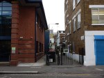
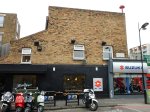
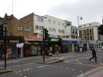
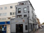
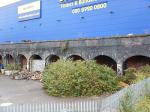
Tooting Broadway
These pictures show the area around Tooting Broadway station.


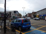

Tooting Broadway station is a typical Underground station on a busy surburban shopping street, that appears to be ruined by heavy traffic. I certainly wouldn’t go there to shop.
Tooting Broadway station is in the London Borough of Wandsworth
It is on the Northern Line
The Crossrail 2 document says this about a station at Tooting Broadway.
To relieve crowding on the Northern line, we had proposed a station at Tooting Broadway. Land for this was safeguarded earlier this year and further work on the station design has been completed to inform this consultation. Recent assessments have identified that ground conditions in the Tooting area would make it significantly more difficult to build a station at Tooting Broadway than originally thought. As a result of these challenges, we are looking at an alternative station location at Balham.
Work to date has suggested that a station at Balham could be built with significantly less disruption and would still provide many of the same transport benefits as a station at Tooting Broadway.
A station at Tooting Broadway would take up to two years longer to build, would require much larger worksites and thousands more lorry movements. This is because a station there would have to be built from the surface with more material removed by road. This would mean it would be more disruptive and cost nearly twice as much to build than a station at Balham.
I also think that even the world’s greatest architect, would have problems creating a decent station for the area.
If I lived in Tooting, I’d think that all those lorry movements would say that Balham can have the station and I’ll go there for shopping and entertainment.
Perhaps the only reason to build a station at Tooting Broadway, would be that it would make it easy to get away from the place.
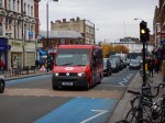
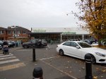
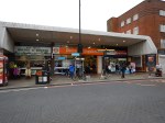
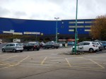
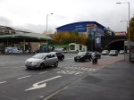
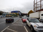
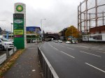
Balham
These pictures show both the Tube and main line station at Balham.


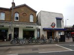


I have a feeling that Balham is a very rare design for a Tube station in that it has two buildings on either side of the road and I can imagine that Crossrail 2 could serve Balham with a double-ended station with entrances on both sides of the High Road.
A good architect could create a world-class station here, that could act as a magnet for visitors and businesses to the area.
Balham station is in the London Borough of Wandsworth
It is on the Northern Line and also a busy station, through which the Brighton Main Line passes.
There are three trains an hour from Victoria to Epsom via Balham, which is a route duplicated by Crossrail 2. Could there be scope for cutting a few services?
This Google Map shows Balham station.
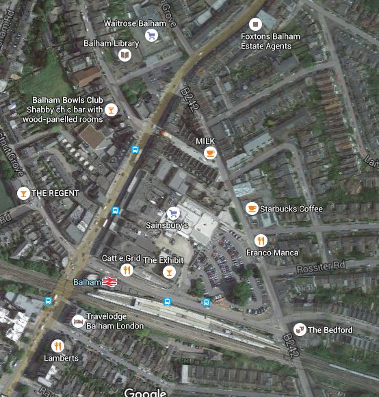
BalhamStation
The Northern Line crosses the main line at virtually a right angle following Balham High Road. The Crossrail 2 line will be built on the Western side of and parallel to the Northern Line.
The two lines would be linked by dedicated passenger tunnels, effectively creating a four platform underground station.
This link means that Crossrail 2 will go some way to meeting a secondary objective of relieving capacity on the Northern line.
It also enables anybody coming from or going to stations south of Balham, like Tooting Broadway for instance, will have a faster route to Central London.
Two work-sites would be used to sink shafts to the new line and Crossrail 2 station.
- Site B – A Northern one on the site of Balham Waitrose.
- Site A – A Southern one just south of where the Northern Line crosses the main rail lines.
It is worthwhile looking at the main lines through Balham on this Google Map.
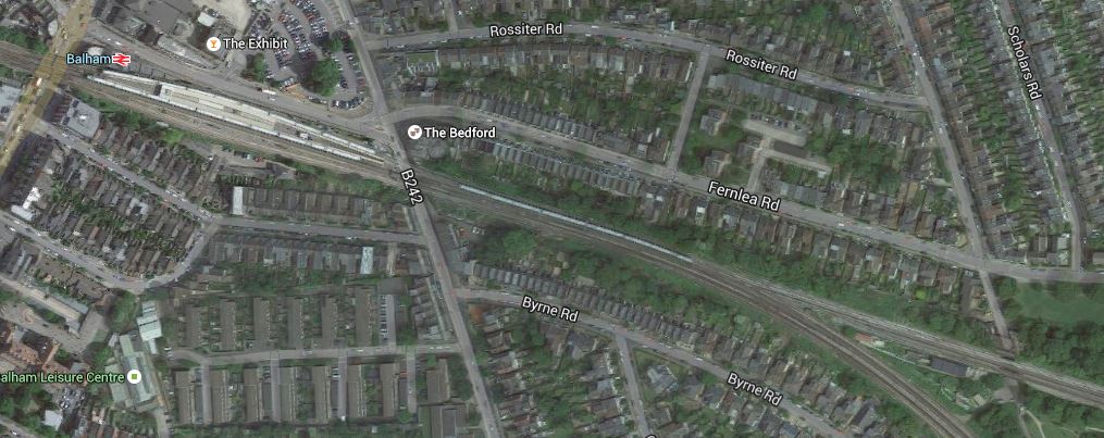
Lines Through Balham Station
Note how the lines split to the East of Balham station, with the Brighton Main Line going south.
If you’re building a new Crossrail 2 station at Balham, you should probably rebuild and extend Balham station if that is required to improve services on the Brighton Main Line.
You’ve certainly got a lot of space!
Balham and its new Crossrail 2 station looks an excellent solution, especially as the link between the Northern Line and Crossrail 2 could be made so simple and totally step-free.
Making The Decision
So on a quick look, it would appear that Balham offers the better connectivity and Tooting has ground faults and would be much more difficult, expensive and disruptive to build.
Let’s face it, Tooting does not have any of the charm and space of Balham and save for complete demolition, Tooting Broadway is probably beyond redemption.
In some ways, it gives Sadiq Khan a difficult problem if he is elected Mayor next year. Should he insist as Mayors possibly can, that Crossrail 2 call at Tooting Broadway in his current constituency?
On what I have written here, I think it would be a seriously wrong decision to chose Tooting Broadway.
Atlantic Superconnection Features In The Sunday Times
I am an electrical engineer by training and although possibly the only work I’ve done in the power field directly is to wire a plug, I know the technology of power generation fairly well.
Ever since I went to Iceland last year and first heard about IceLink, I’ve followed the project with interest.
Today there is an article in The Sunday Times entitled Cameron wants sea cable to bring lava power from Iceland.
It talks about the involvement of a company called Atlantic Superconnection
Read the article and follow the company!
Crossrail 2 October 2015 – Capacity On The West Anglia Main Line
The West Anglia Main Line is an overcrowded line from Liverpool Street to Cambridge, Ely and Stansted Airport.
This Crossrail 2 document is entitled Services at Broxbourne, Cheshunt and Waltham Cross.
It says this about creating more capacity.
To create the extra capacity needed to run more services along the West Anglia Main Line, Crossrail 2 would require the addition of more tracks along the route from south of Tottenham Hale station to north of Broxbourne station. This would also allow for a further four trains per hour from all stations on the line to Stratford, in addition to Crossrail 2. In addition, the new tracks could also enable an increase in the number of faster longer-distance services between Liverpool Street, Bishop’s Stortford and Cambridge. We are still at a very early stage in the development of our proposals for the new tracks. We will carry out further consultation in the local areas about these proposals as they develop.
This is the first time, I’ve read that services all Lea Valley stations like Brimsdown, Cheshunt and Broxbourne will have a four trains per hour service to Stratford.
At present there are just a few trains per hour from Stratford to Bishops Stortford, but with the opening of the new Lea Bridge station next year, this may be turned into a more frequent service.
There is also talk of a service called STAR that links Stratford to Angel Road station.
There is a lot of circumstantial evidence on the Internet that mainly because of the need for more and faster longer distance services, whether Crossrail 2 is built or not, that the West Anglia Main Line will be given extra tracks from South of Tottenham Hale station to North of Broxbourne station.
If four tracks were provided this would allow the separation of slow and faster services.
But it would not be a trivial project as all the stations from Tottenham Hale to Cheshunt would need to substantially modified, with most given one or more extra platforms.
Although once it was finished, it would have created the tracks andreadied the station sites for the buildimng of the North-Eastern branch of Crossrail 2.
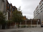
Crossrail 2 October 2015 – Tottenham Hale Tunnelling Site
This Crossrail document is entitled Tunnelling Worksite At Tottenham Hale.
This is said.
A new Crossrail 2 portal at Tottenham Hale would include the following:
A retained cutting approximately 300 metres long where the surface railway gradually descends to the tunnel entrance
The tunnel entrance, where the surface railway enters the tunnel and the tunnel boring machines would start from during construction
A worksite for building and equipping the tunnels
It’s all quite simple really and this Google Map shows the area.
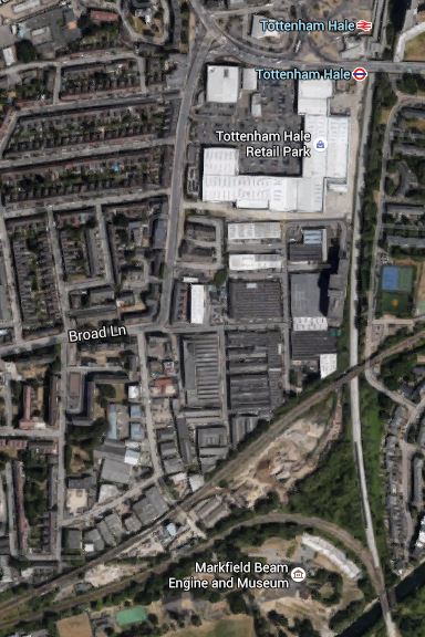
Tottenham Hale Tunnelling Worksite
The worksite is the triangular area, bounded by rail lines, north of the Markfield Beam Engine and Museum. The rail lines are.
- The North-South West Anglia Main Line.
- The East-West Gospel Oak to Barking Line.
- The curve that allows trains to pass between the two other lines.
You can get a good view of the site from both of the first two lines.
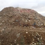

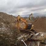
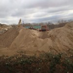
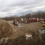
The site seems to be mainly a site that collects London’s demolition rubbish. Some of the pictures came from Could This Be Where Crossrail 2 Is Dug?
In addition to the tunnel portal here, it may also be the starting point of the four-tracking of the West Anglia Main Line to increase capacity.
I have always assumed that the two new slow lines that are being built alongside the West Anglia Main Line will be built on the Eastern side of the current two tracks. I could have made a wrong assumption, but if this is the case, there will need to be tunnels under the main lines so that Crossrail 2 can join up with the slow lines.
Crossrail 2 October 2015 – Stations
This Crossrail 2 document is entitled A Typical Station.
Read the document and you’ll see that a typical station has the following.
- Two 250 metre long platform tunnels with platform edge doors.
- Several cross tunnels
- Shafts at each end of the platforms for ventilation and evacuation.
It does look as if they’ve gone for the simplest design possible, that meets all needs and regulations.
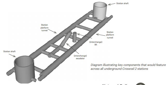
I’ve been in two Crossrail stations and it does seem that this design is simpler.
Good News For Redcar
I have a Google Alert set for “York Potash”, as contrary to the media who are ignoring the story, I believe that the new potash mine at Whitby being developed by York Potash could be economically valuable to the area around Middlesbrough.
The Alert found this article on a web site called Engineering and Mining Journal entitled Sirius Minerals Receives Approval For York Potash.
The article gives a positive report on the mine. I liked this bit.
The project lies between Whitby and Scarborough, extending about 16 km inland from the coast and up to 14 km offshore. According to the company, York potash will be a deep-shaft mine of unprecedented design. Within this area lies the thickest and highest grade polyhalite ore reserve in the world. Development of the 20-million-metric-ton-per-year (mt/y) operation would take place in two phases. The first phase is designed provide 10 million mt/y before scaling up to full capacity over a number of years.
That is serious engineering and a hell of a lot of potash.
Hopefully, it’ll give an upturn to the workers and residents of Teeside.
A quick estimate gives that the full capacity of the mine, is equivalent to about the weight of nine hundred HMS Invincibles, give or take a Harrier or two.
Dutch Leave Passengers In The Cold
This article on Global Rail News is entitled Dutch Minister Resigns Over Fyra Failures.
The first paragraph sums up the article.
Dutch infrastructure minister Wilma Mansveld has resigned following the publication of a highly critical report on the failings of the Fyra high-speed rail fiasco.
The report, which was led by CDA parliamentarian Madeleine van Toorenburg, said that passengers had been “left out in the cold” by the HSL-Zuid project.
The second paragraph gave me the title for this post.
But as I effectively said in Back From The Hague, the Dutch, Belgians and Germans couldn’t organise a piss-up in a brewery!
So no wonder there’s frozen passengers all the way from Amsterdam to Brussels.
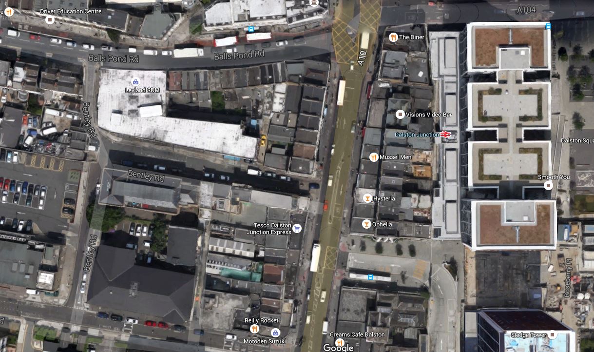
Crossrail 2 October 2015 – Dalston Station
Are us plebs in humble Dalston going to get one of the best and busiest stations on Crossrail 2?
I wrote that opening statement in jest, but think about the proposed combined Dalston station’s position in London’s rail network.
- It is the most Northerly station before the two branches to New Southgate and Broxbourne link under Stamford Hill.
- Dalston Junction (Or is it Dalston South?) gives an escalator connection between Crossrail 2 and an up to twenty-four trains an hour to South-East London on the East London Line.
- Dalston Kingsland (Or is it Dalston North?) gives an escalator connection between Crossrail 2 and all those trains on the North London Line.
So Dalston will become the important interchange for a large number of cross-London journeys. Raynes Park to New Southgate may well be direct, but so many journeys like Norwood Junction to Brimsdown will just be a single change at Dalston.
Crossrail 2 will put Dalston in one of the most important places on the map of London’s rail network.
Crossrail 2’s proposal for Dalston Station
This Crossrail document is entitled Dalston Station.
The proposal in the document starts like this.
The Crossrail 2 station at Dalston would be a double-ended station, with an interchange at Dalston Junction at the southern end, and an interchange with Dalston Kingsland at the Northern end.
So we get three stations in one, which also means that at last there will be a true dry interchange between Dalston Kingsland station on the North London Line and Dalston Junction station on the East London Line.
This map from the document shows the layout of the two existing stations and their connection by means of two two-hundred and fifty metre long underground Crossrail 2 platforms.

Crossrail 2 Dalston Station
It would appear that two shafts will be sunk to the Crossrail 2 tunnels.
- The Southern one would be in the Tesco Express or the bar next door,
- The Northern one would be just to the north of Ridley Road in the block containing the NatWest Bank.
Note how much of the route of the Crossrail 2 tunnels, runs on the East side of Kingsland High Street, under the Shopping Centre and the new flats. The tunnels will be at least twenty metres down just to get past High Speed One, which runs under the North London Line and Dalston Kingsland station, so any older buildings will be well above any Crossrail 2 construction.
I would also suspect that High Speed One also makes designing and construction of the Kingsland end of the station challenging.
The Work Sites
The Crossrail 2 proposal for Dalston station is nothing but ambitious and to build it there will be no less than five work sites.
- Site A – Would be used as the main site for construction of the station tunnels and southern station shaft
- Site B – Would be used for construction of a new Crossrail 2 station entrance and ticket hall. The site includes properties on the southern side of Bradbury Street.
- Site C – Would be used for construction of the northern station shaft and escalator connection to the Crossrail 2 platforms
- Site D – Would be used for construction of a new bridge providing access from the new ticket hall to the westbound platform at Dalston Kingsland
- Site E – Would be used for construction of a station entrance and ticket hall, for interchange with Dalston Junction station.
But I would be very surprised if the work wasn’t phased so that the work-load in Dalston was spread and work is performed in a logical order.
Dalston Kingsland station is a dump compared to Dalston Junction station, with all the charm, access problems and convenience of a Victorian tube station.
In a reasonable world, it would be replaced now, whether Crossrail 2 is built soon or postponed to the Twenty-Second Century.
The need for a Site D indicates that a new bridge will be built across the station to give access. As Site D is currently in the construction site for new flats called Fifty Seven East and Dalston Kingland station desperately needs step-free access, then surely this bridge should be built now!
To further assess the work-sites, I walked along Tottenham Road to Site A, then crossed to Site E, before walking up Kingsland High Street to look at Sites B, C and D.


There is certainly, a lot going on and if everybody gets it right, it can become one of London’s more important High Streets.
What Is Already Happening In Kingsland High Street?
Before I come to my conclusions, I’ll say a little about what is already happening.
- Plans may have been published to rebuild Dalston Kingsland station.
- There are more projects to build flats in the area. London needs housing and as these will be designed so they don’t affect Crossrail 2, they will go ahead.
- The Dalston Kingsland Shopping Centre is supposed to be being rebuilt.
- There are also plans to improve the pedestrian flows on what is a very congested road for walkers.
- There will be other changes due to the Cycle Superhighway passing about fifty metres to the west of Kingsland High Street.
So in say four or five years time, we should have a better High Street and Kingsland station, whether Crossrail 2 is coming or not!
Conclusions
So what are my initial conclusions?
- Because of the station design, there will need to be some demolition at both current stations.
- Site A needs a full rebuild, as it has very little property of merit and I certainly wouldn’t miss the Subway, Tesco and the bar on the end. The shaft to access the new platforms, will probably be in the middle of the current Tesco.
- Site B is in a bad state with much of the property locked up. Some of the properties on Bradbury Street will need to be demolished to rebuild Dalston Kingsland station, let alone build the Crossrail 2 station. Will anybody mourn?
- Site C is where the Northern shaft will be. There will be some demolishion.
- Site D is a curious one in that it is inside a site that is being developed.
- Site E is where the new entrance to |Dalston Junction and the Crossrail 2 station is going to be built. I’d have hoped that the Crossrail 2 passages would have been laid out in the redesign of the Overground station. What’s been published gives me doubts!
- How much of the demolition will be of properties worth keeping? Those that I photographed didn’t shout save me!
There are three sites on the High Street, which will be very much affected by the rebuilding of Dalston Kingsland station and building of Crossrail 2.
- Site A, where the Southern shaft for the station is located.
- Site B, where the Northern entrance to the new station is proposed, is substantially closed at present.
- Site C, opposite Dalston Kingsland station that will contain the Northern shaft for the station and escalator connection to the Crossrail 2 platforms.
All could be developed with new residential or commercial properties on top.
I believe that the proposed plan for the new Crossrail 2 station should be treated as what it is, just a proposal.
Or at least as far as the above ground presence is concerned.
All three sites could be developed as welcoming portals to enhance the public transport system as it serves the area around Dalston.
I would apply the principle, that access to the Crossrail 2 station, should be available from both sides of Kingsland High Street at both the Northern and Southern ends.
I will now look at each site in detail.
Site A
This is a Google Map showing Dalston Junction station and Site A.
Dalston Junction Station And Site A
Note the station and its towers above in the East and Bentley Road Car Park in the West. You should be able to pick out the Tesco Express on the Kingsland Road.
I walk to Dalston Junction station most days to get the Overground. But it is not a good walking route.
- The pavements along the Balls Pond Road and Kingsland Road are very narrow and you are squashed between traffic and large numbers of walkers.
- It is easier to walk up Tottenham Road, but as with the other route crossing Kingsland Road can be difficult.
- If you live to the South West of Dalston Junction station, it is probably easier to walk to Haggerston station, as I do sometimes.
- It is particularly difficult to cross at the cross roads where the Balls Pond Road meets the Kingsland Road.
As the frontage of Site A on the Kingsland Road will have to be substantially demolished, in an ideal world, provision would be made to access the escalator and lift connection to the Crossrail 2 station from the West side of Kingsland Road.
Perhaps when the frontage of Site A on Kingsland Road is rebuilt after Crossrail 2 works have finished, it should provide a subway under the road to the station and the sort of shops and cafes, that passengers like in their stations.
It would welcome those, who live to the South West of Dalston Junction station to the area, just as Dalston Square on the other side of the station welcomes those from the South East.
Site B
This is a Google Map showing Dalston Kingsland station and Sites B and C.

Dalston Kingsland Station And Sites B And C
Site B is to the North of Dalston Kingsland station, on the West side of Kingsland High Street.
Note that this map was made before the construction of Fifty Seven East started, as Peacocks is still on the West side of Kingsland High Street.
I feel that if they rebuild Dalston Kingsland properly, then then are possibilities to not only build residential or commercial development on top of Site B, but over the railway and the station as well.
Land is expensive and the station occupies almost as much space as Fifty Seven East, so surely a similar sized development over the station would be a welcome addition to London’s housing stock.
I would also hope that the design of the station includes the following.
- A step-free subway under Kingsland High Street to Ridley Road Market. This is probably a given, as the escalators to Crossrail 2 go down from Site C.
- As the station is close to the Cycling Superhighway, I suspect that it will be heavily used by cyclists, who would need lots of secure bike parking.
- Personally, I would like easy walking access along Bradbury Street as I regularly walk to Dalston Kingsland station along that route.
There are certainly lots of possibilities to make the existing Dalston Kingsland station a welcoming North West gateway to Crossrail 2 and Kingsland High Street.
Site C
This is a Google Map showing Dalston Kingsland station and Sites B and C.
Dalston Kingsland Station And Sites B And C
Site C is to the North of Dalston Kingsland station, on the East side of Kingsland High Street. The NatWest bank, which is at the Northend of Site C is indicated.
Any development on this site must enhance the Ridley Road Market and provide that gateway for those travelling to and from the North East of the station.
It is essential that there is an entrance to the station on the East side of Kingsland High street, to give good connections to the market and the Shopping Centre.
My Ultimate Test Of The New Station
My ultimate test of the new Dalton station would be on a cold and wet day, to have the ability to arrive at Dalston Kingsland station on the North London Line, go down an escalator to Crossrail 2, where I can walk along to the Southern End, go up the escalator and exit the station on the West side through a rebuilt Site A.
And do it pushing my yet-to-be-born great-grandchild in a buggy! The spirit of my grandmother, who was born opposite Dalston Junction station would be very pleased!
Crossrail 2 October 2015 – Tunnels, Shafts And Head-Houses
Crossrail 2’s underground structures will be very similar to those of Crossrail.
Tunnels
The tunnels will be built in the same way to those of Crossrail, using tunnel boring machines or TBMs.
But I believe there will be slight differences.
- The tunnels of High Speed One, which Crossrail 2 has to cross at Dalston, are at a depth of 34 to 50 metres, so will we see Crossrail 2 bored across London below all the other foundations and infrastructure?
- Crossrail 2 will be built some years after Crossrail and tunnelling technology is improving by leaps and bounds.
- Because Crossrail 2 tunnels will be going through similar terrain to Crossrail, I wouldn’t be surprised to see a much faster process, simply because everything is easier, the second time around.
- Tunnel spoil will probably be taken away by rail, as only the Tottenham Hale site has access to water.
These tunnels under London are getting very much a routine task.
Shafts
There is a Crossrail 2 document entitled Crossrail 2 Shafts.
This is said about the need for shafts.
Shafts would connect the underground Crossrail 2 tunnels with the surface. During everyday operations, the motion of trains would push air out of the tunnels and pull air into them from the atmosphere. As the air pushed out is usually warmer than the air pulled in, the shafts would help to provide a more comfortable temperature for passengers and staff. During periods of disturbed service, when trains could be held in Crossrail 2’s tunnels for an extended period of time, the shaft’s ventilation system would deliver cooler air from the atmosphere to the tunnels and to stationary trains. In the unlikely event of a fire, the shafts would control smoke, provide access for the fire and rescue services and provide a safe evacuation route for passengers.
The document also describes what a shaft might look like.
Most of the shaft would be underground with an aboveground structure known as a ‘head-house’. This would provide access to the shaft itself, the equipment within it and the tunnels below. A head-house is ideally located directly above the shaft and tunnels, except in some cases where they can be located separately and connected by a short underground passage. A street-level entrance would provide access for the fire and rescue services, for the safe evacuation of passengers in an emergency as well as for maintenance. Direct access to the head-house is required for emergency and maintenance vehicles.
A typical head-house is also described.
At stations the head-house would typically be integrated with the overall station structure. At locations between stations the head-house would be separate. At this early stage of Crossrail 2 design, we expect a typical headhouse to occupy an area of around 25 metres by 25 metres and to be at least two storeys high – although the size of each head-house would be influenced by local factors including the depth of the tunnels and the height of surrounding buildings at each site. Further design work would be required to determine our requirements at each individual location.
As the Crossrail 2 scheme develops further, we would engage with the relevant local authority, interested stakeholders and local communities to inform the designs for each head-house.
But although the head-houses for the Channel Tunnel Rail Link were all very similar, it is true to say that there is nothing like a standard shaft and head house.
The Ventilation Shafts For Crossrail And The Channel Tunnel Rail Link
It is worthwhile looking at the shafts and head-house designs for Crossrail, which I described in The Ventilation Shafts For Crossrail.
Every one seems different, although I suspect that there lots of similarities in the equipment used.
But compare those with those of the Channel Tunnel Rail Link.
The only certainty about the shafts and head-houses of Crossrail 2, is that they will be smaller, more elegant and better designed.
Crossrail 2 October 2015 – New Southgate Station
This post looks at the works around New Southgate station.
I’ve known this area for over sixty years, as when my father used to take me to his printing works in Wood Green, he would drive past New Southgate and Alexandra Palace stations. Some parts have hardly changed in that time.
In my mind Alexandra Palace station will always be Wood Green station, whereas the Piccadilly Line one will always be Wood Green Tube station.
This Google Map show the area.
Crossrail 2 In New Southgate
New Southgate station is in the top left (North East) and Alexandra Park is at the bottom.
Note the following.
- The Hertford Loop Line branches off North of Alexandra Palace station to the North East.
- The station on this line is Bowes Park.
- To the right (East) of this junction is Bounds Green Depot, where the long distance expresses to the North are stabled and serviced.Bounds Green Depot is due to be upgraded for the new Hitachi trains that will run the services in the next few years.
- There is a tunnel between New Southgate and Alexandra Palace stations
In this document on the TfL website entitled New Southgate Station, details are given of how Crossrail 2 will be fitted into the area and connected to the East Coast Main Line. This Google Map shows the area North and South of New Southgate station.
Crossrail 2 Sites At New Southgate
There are three main areas of work-sites, all of which are to the East of the railway. Because of the amount of concrete and industrial roofs, they show up white on the map.
- The top site alongside Oakleigh Road South (A109) is shown on old maps as being railway sidings, is a proposed site for the train depot and stabling, Crossrail 2 and tnnelling support.
- The second site squeezed between the railway and North of the A406, will be the station site, where new Crossrail 2 platforms will be built.
- The third site to the South of the A406, which is now part of the Bounds Green Industrial Estate, will be the actual tunnel portal.
One by-product of all this work could be that the North Circular Road (A406) at this point could be opened out. This Google Map shows the area, where the Crossrail 2 station will go, the bridge over the A406 and the area around the proposed Crossrail 2 tunnel portal.
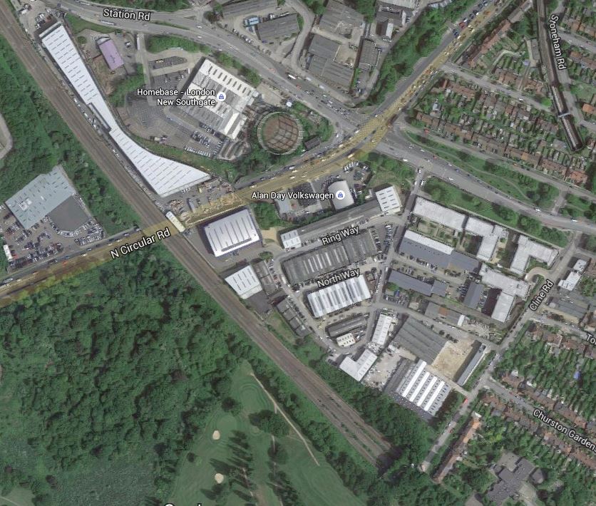
Crossrail 2 Over The A406
Note the following.
- The map shows most of the two southern work sites for Crossrail 2.
- Looking at this it would appear that the Crossrail 2 tunnel portals will be on that green space alongside the portals of the existing tunnels.
- The white almost boot-shaped building will be replaced with Crossrail 2 platforms.
- The bridge appears to extend far enough to take the extra Crossrail 2 tracks over the A406. It looks like it is used for truck parking at the moment.
- Could the condition and size of the bridge, mean that there would be little disruption to traffic durin construction?
- There doesn’t appear to be an demolition of residential property.
I just wonder if a top class architect could give New Southgate a spectacular station above the A406.
I’ve driven under that bridge so many times and can see some form of sculptured steel, brick and glass building with a giant Crossrail roundel advertising its presence.
These pictures were taken as I walked down past New Southgate station and crossed the A406.
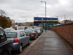
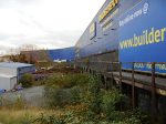
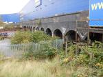
The Builder Depot is the boot-shaped building and it looks as if it was built on an old railway embankment.
The North Circular Road was certainly very busy.
