East Midlands Commuter Programme
The East Midlands Commuter Programme has been launched.
It has its own web site, with this mission statement.
Working Towards A Sustainable/Healthy/Prosperous East Midlands By Investing In Rail
And this more expansive statement.
East Midlands Commuter Programme is a scheme to introduce a high-frequency and high-quality rail service across the East Midlands with as little new infrastructure as possible, as well as lobbying for the extension of NET trams into Derby, East Midlands Airport and more.
So what is the flesh on the bones?
Four Stages
These are.
- Stage One – Building the Core
- Stage Two – Trams and Stations
- Stage Three – A Vital Stage For Heavy Rail
- Stage Four – Achieving Twenty trams per hour Through Toton
It looks to me, that there is the start of good things there, but full information is not on the web site yet.
Every plan put forward must be capable of being built.
I shall not comment further until the plan has been completed, published and handed to the Government.
Liverpool’s Vision For Rail was published by the region in July 2021 and it is a complete and well-thought out plan.
In October 2021, I was able to write Chancellor To Fund £710m Merseyrail Expansion.
Work has already started on the first extension to Headbolt Lane station.
At a very much smaller level, look what happened in Devon with the Dartmoor Line, where a small scheme was delivered quickly.
We now also have two further smaller well-planned schemes underway; the Northumberland Line and the Levenmouth Rail Link in Scotland.
Conclusion
I would suspect, that if the East Midlands can write a plan that is complete, fully-costed and deliverable, then they will get the same result as the Liverpool City Region.
Is A High Capacity Freight Route Being Created On The Midland Main Line?
In the January 2022 Edition of Modern Railways, there is a section, which is entitled Mixed Fortunes For Freight In IRP, where IRP is short for Integrated Rail Plan For The North And Midlands.
In the section, this is said about freight on the Midland Main Line.
Whilst HS2 does relieve the MML, electrification of the route north from Kettering via Derby to Sheffield is of relatively limited use to freight, which is generally routed via Corby and Toton to Chesterfield and Rotherham. That said, assuming electrification of the passenger route includes the slow lines from Leicester to Trent and through Chesterfield, it does provide a base on which freight electrification can be built.
This would involve wiring Corby to Syston Junction (north of Leicester), Trent Junction to Clay Cross (south of Chesterfield) and Tapton Junction (north of Chesterfield) to Rotherham Masborough and Doncaster.
As with the ECML, this ‘freight’ electrification would provide a diversionary route and thus greater resilience for East Midlands Railway services.
In addition, gauge clearance throughout from Corby as part of this package would also be highly beneficial in creating a direct route from the ‘Golden Triangle of Logistics’ in the East Midlands to the North East and Scotland for consumer goods supply chains, boosting modal shift to rail and decarbonisation.
It does seem to be a cunning plan worthy of Baldrick at his best.
So is it feasible?
Which Routes Do Freight Trains Use Now?
Christmas in a pandemic, is not a particularly good time to look at the routes freight trains take.
But by looking at Real Time Trains, I can say this.
- Many trains take the route via Corby and Syston Junction, rather than the direct route via Market Harborough and Leicester.
- Leicester is quite busy with freight as trains between Felixstowe and places on the West Coast Main Line, go through the station.
- Very few freight trains seem to take the route via Derby and the Derwent Valley Mills.
- Most freight trains between East Midlands Parkway and Chesterfield seem to take the Erewash Valley Line via Toton and Ilkeston.
I don’t think the pattern will change much, if I look at the trains around the end of January.
What Do I Mean By European-Size Freight Trains?
The Wikipedia entry for loading gauge says this about about the route through the Channel Tunnel and up the Midland Main Line.
UIC GC: Channel Tunnel and Channel Tunnel Rail Link to London; with proposals to enable GB+ northwards from London via an upgraded Midland Main Line.
Note.
- . GC is 3.15 metres wide by 4.65 metres high.
- GB+ is 3.15 metres wide by 4.32 metres high.
- GB+ is intended to be a pan-European standard, that allows piggy-back services.
- British gauging is so complicated, it isn’t specified in standard units. It must be a nightmare for rolling stock designers.
I’ll take an easy way out and assume that by European-Size Freight Trains, I mean that the route must be cleared for GB+ gauge.
Could Kettering and Syston Junction Via Corby Be Cleared For European-Size Freight Trains?
According to a Network Rail Map from February 2010, the current clearance is as follows.
- Kettering and Oakham – W7
- Oakham and Syston Junction – W8
Note.
- Oakham and Peterborough is also W8
- The main problem seems to be that between Corby and Oakham, there are five tunnels; Corby, Glaston, Manton, Seaton and Wing.
- There are also a few overbridges and several level crossings, but they don’t look too challenging.
- Between Corby and Oakham, there is the magnificent Welland viaduct, which has eighty-two arches and is Grade II Listed.
- Ideally, freight operators would like to run European gauge piggy-back services, with road trailers travelling on flat wagons, as they do in CargoBeamer services.
It would be a tough call to satisfy my last point, but if it can be done it would allow all Midland Main Line freight trains to take the Corby diversion and this would remove the problems of running European gauge trains through Leicester station.
This Google Map shows a section of the Welland viaduct.
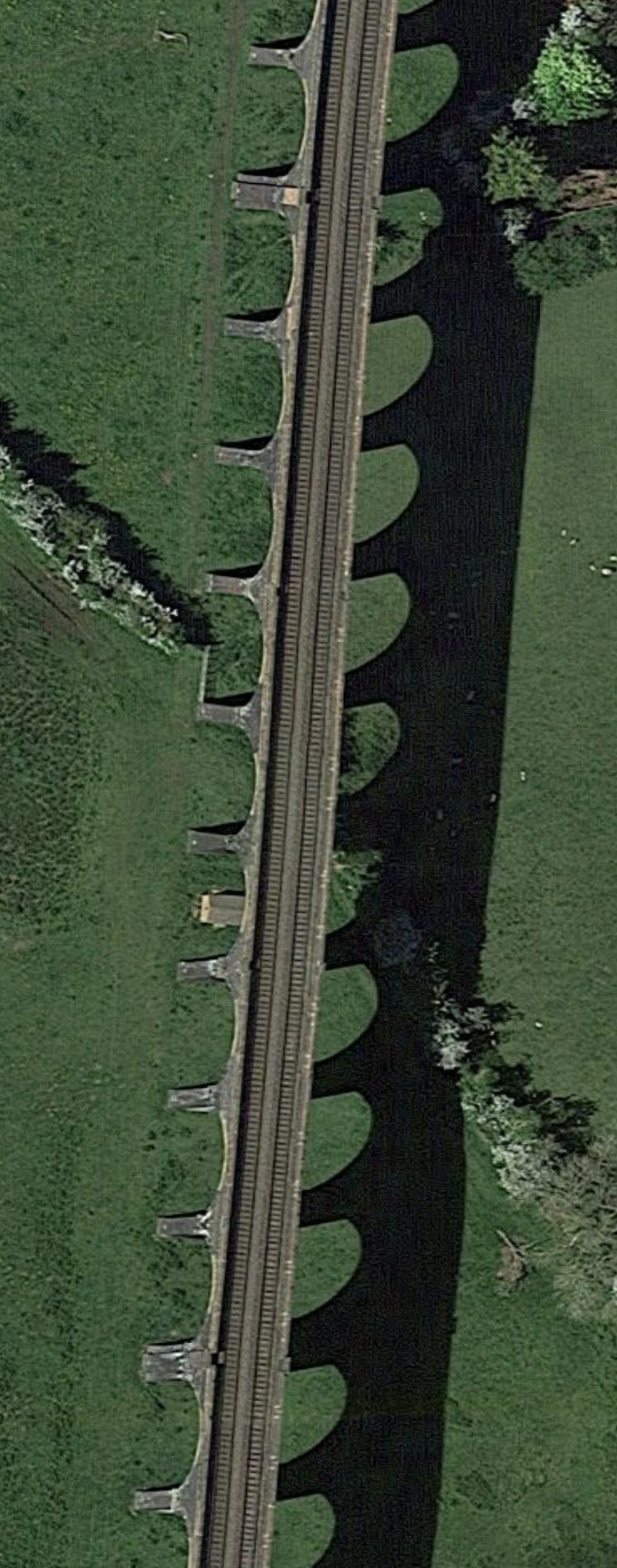
It could be key, as it is fully double-track.
But could it support two heavy freight trains at the same time?
But it would be some sight to see, long European-sized freight trains running over the viaduct.
Could The Midland Main Line Between Syston And Trent Junctions Be Cleared For European-Size Freight Trains?
The route is cleared to W7 or W8 between the two junctions and on inspection with my virtual helicopter, I suspect it wouldn’t be that challenging to upgrade.
It would also be sensible to clear the Castle Donnington Line for European-size freight trains, so that they could reach the East Midlands Gateway freight terminal.
This Google Map shows the location of the East Midlands Gateway.
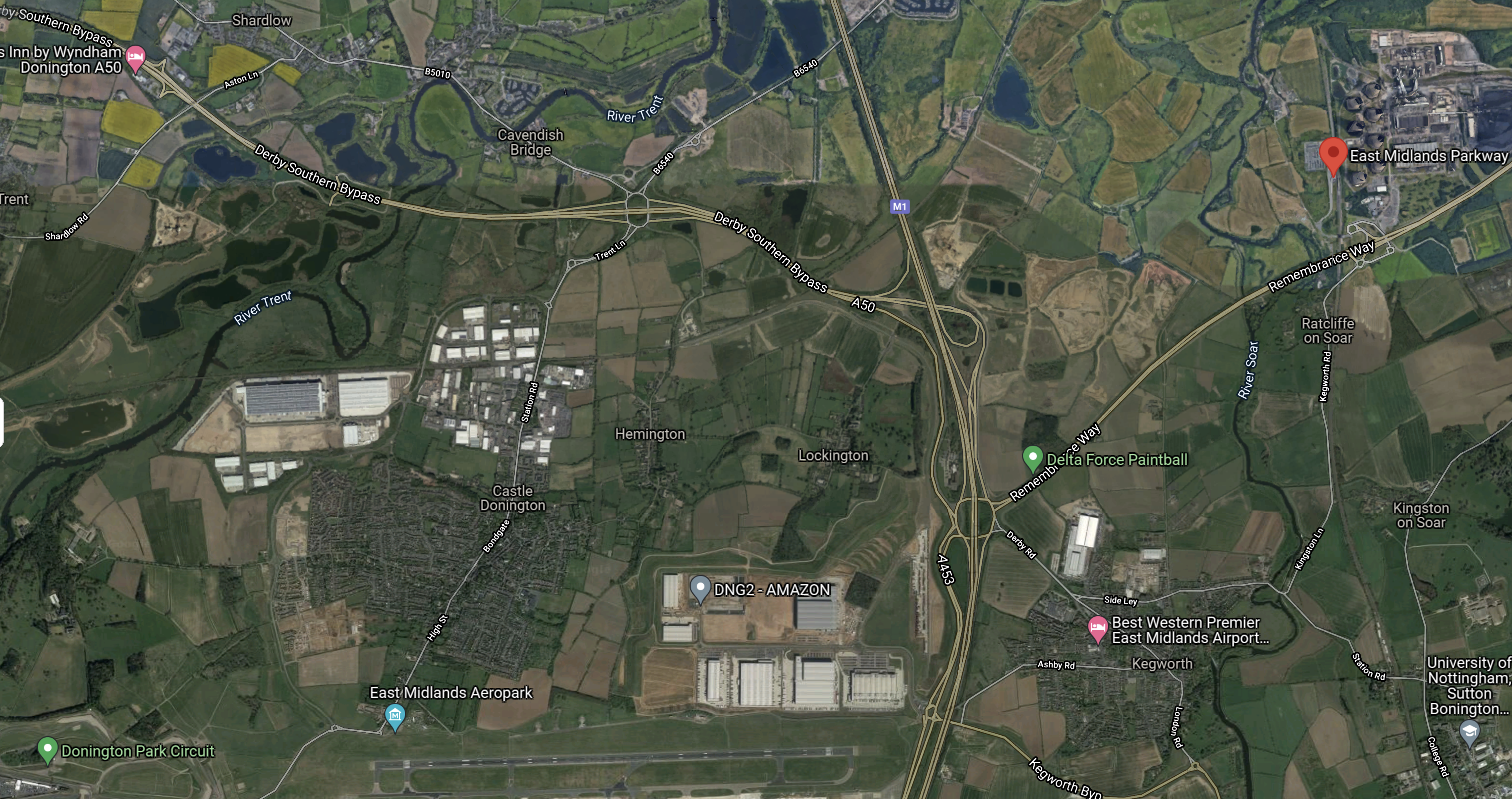
Note.
- East Midlands Parkway station is marked by the red arrow in the North-East corner of the map.
- Castle Donnington circuit is in the South West corner of the map.
- The long East-West runway of East Midlands Airport is clearly visible.
- East Midlands Gateway is to the North of the airport.
This second Google Map shows East Midlands Gateway in more detail.
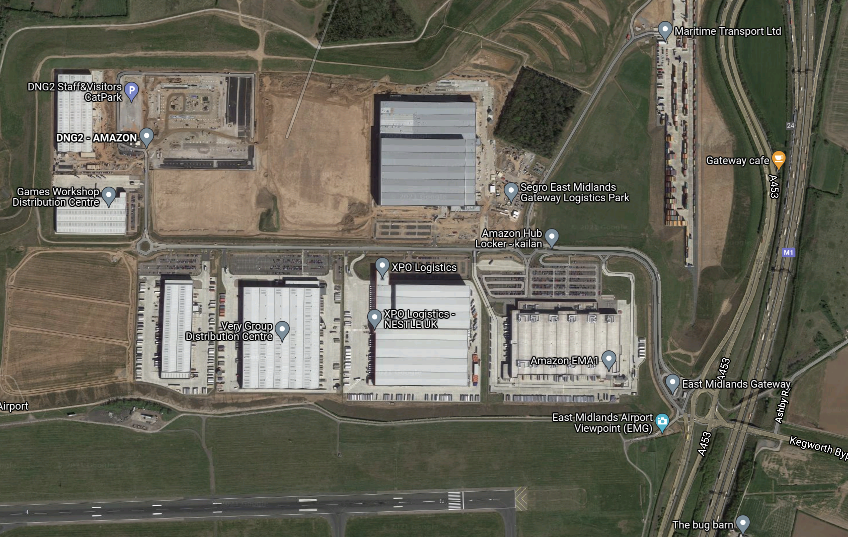
Note.
- In the North-East corner is Maritime Transport’s rail freight terminal.
- The M1 runs North-South at the Eastern edge of the map.
- East Midlands Gateway Logistics Park with two Amazon sheds is in the middle.
- The runway at East Midlands Airport is clearly visible.
The Integrated Rail Plan for the North And Midlands has already announced that High Speed Two will join the Midland Main Line to the South of East Midlands Parkway station to serve Derby, Nottingham and Sheffield.
- This new line will have to go past the airport, either to the North of the Logistics Park or South of the Airport.
- Could there be a station here, both for passengers and the workers at a very busy freight airport and Logistics Park?
- Currently, trains between the rail terminal and London, London Gateway and the Port of Felixstowe have to reverse North of the rail terminal to access the terminal.
- All the rail links between the Midland Main Line and East Midlands Gateway would need to be built to accept European-size freight trains, to ensure maximum flexibility.
It strikes me, that there are a lot of extra features that could be added to the rail network between the Midland Main Line and East Midlands Gateway.
Could The Erewash Valley Line Via Ilkeston Be Cleared For European-Size Freight Trains?
Consider.
- According to a Network Rail Map from February 2010, the Erewash Valley Line is cleared to W8.
- According to Wikipedia, it is the second busiest freight route in the East Midlands.
- Network Rail have spent £250 million on the line in recent years to improve junctions and improve signalling.
- The route doesn’t have a large number of passenger services.
These pictures show Ilkeston station on the Erewash Valley Line.
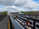
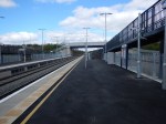

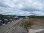
Note.
- The recently rebuilt bridge and the separate avoiding line.
- The Class 158 train under the bridge is 3.81 metres high.
As the European gauge; GB+ is 4.32 metres high, I would feel that Ilkeston station can handle European-size freight trains.
I have flown my virtual helicopter all the way over the Erewash Valley Line from Toton to Clay Cross North junction.
- It looks as if most of the not many bridges are either recent or could be updated to handle the large European-sized freight trains.
- It should also be noted that in many places there is a third track or space for them.
- There are three stations and the Alfreton tunnel.
After this quick look, I feel that the Erewash Valley Line will be able to handle European-size freight trains.
Could Tapton Junction to Rotherham Masborough and Doncaster Be Cleared For European-Size Freight Trains?
This route has very few bridges and I doubt updating wouldn’t cause too many problems.
CargoBeamer
Would it be possible for one of CargoBeamer’s piggy-back trains carrying trailers to run between the Channel Tunnel and the rail terminal at East Midlands Gateway Logistics Park or perhaps another terminal further up the Midland Main Line?
If they could use the Gospel Oak and Barking Line to access the Midland Main Line, I don’t see why not!
Conclusion
It appears that it should be possible to allow European-size freight trains to run between the North of England and the Channel Tunnel.
New ‘HS3’ Link To Yorkshire Proposed By Thinktank After Region’s HS2 Axe
The title of this post, is the same as this article in the Yorkshire Post.
This is the introductory paragraph.
A new “HS3” high-speed rail line between Yorkshire and the Nottinghamshire town of Newark could help make up for the loss of the HS2 eastern leg from Yorkshire, a report by transport think-tank; Greengauge 21 has suggested.
There is also this map from Greengauge 21.
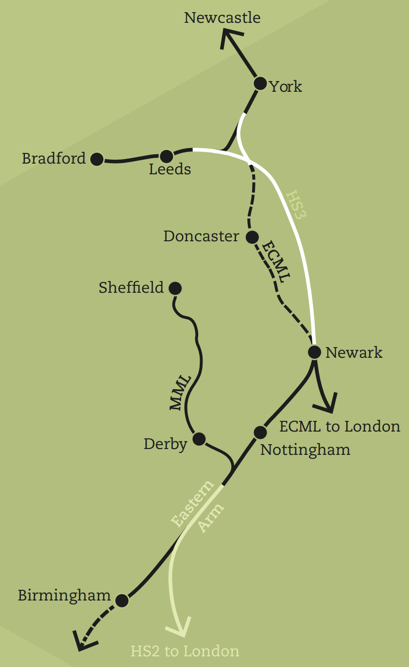
I clipped my copy of the map from this report on Greengauge 21, which is entitled East, West, North And South.
Note.
- As in the Integrated Plan For The North And Midlands, Derby, Nottingham and Sheffield have direct connections to London via High Speed Two.
- The Derby leg is extended to Sheffield via the existing Midland Main Line.
- The Nottingham leg is extended to Newark, where it joins the East Coast Main Line.
- A new High Speed Line, which is shown in white and labelled HS3 links Newark to the East Coast Main Line and the line between Leeds and York at a new triangular junction South of Colton Junction.
- Part of the current route between Doncaster and Colton Junction is the Selby Diversion, which according to Wikipedia was built for speeds upward of 140 mph.
- The route splits in the region of Colton Junction with the Western leg going to Leeds and Bradford and he Northern leg going to York and Newcastle.
I feel this is a better plan than the previous one from High Speed Two.
- It adds Bradford, Derby and Nottingham to the High Speed Two network.
- There is a connection to Birmingham and possibly the South West and Wales.
- The East Coast Main Line is effectively four-tracked between Newark North Gate and York.
I have a few thoughts.
Colton Junction
This junction will feature a lot in this post, so I had better explain where it is.
The Selby Diversion was built in the 1980s to create a new route, which avoided the newly-discovered Selby coalfield.
Colton Junction is about six miles South of York and is at the Northern end of the Selby Diversion.
This Google Map shows the junction.
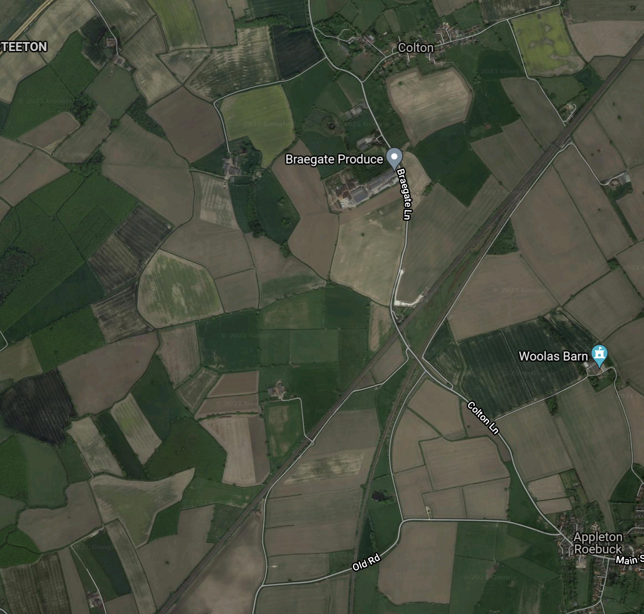
Note.
- The East Coast Main Line going between South-West and North-East across the map.
- The railway going North-East leads to York.
- The village of Colton is at the top of the map.
- Colton Junction is South of the village, where the East Coast Main Line splits.
- The line going South-West is the route without electrification to Leeds, used by TransPennine Express and others.
The line going South is the Selby Diversion, used by all trains on the East Coast Main Line.
East Midlands Hub Or East Midlands Parkway
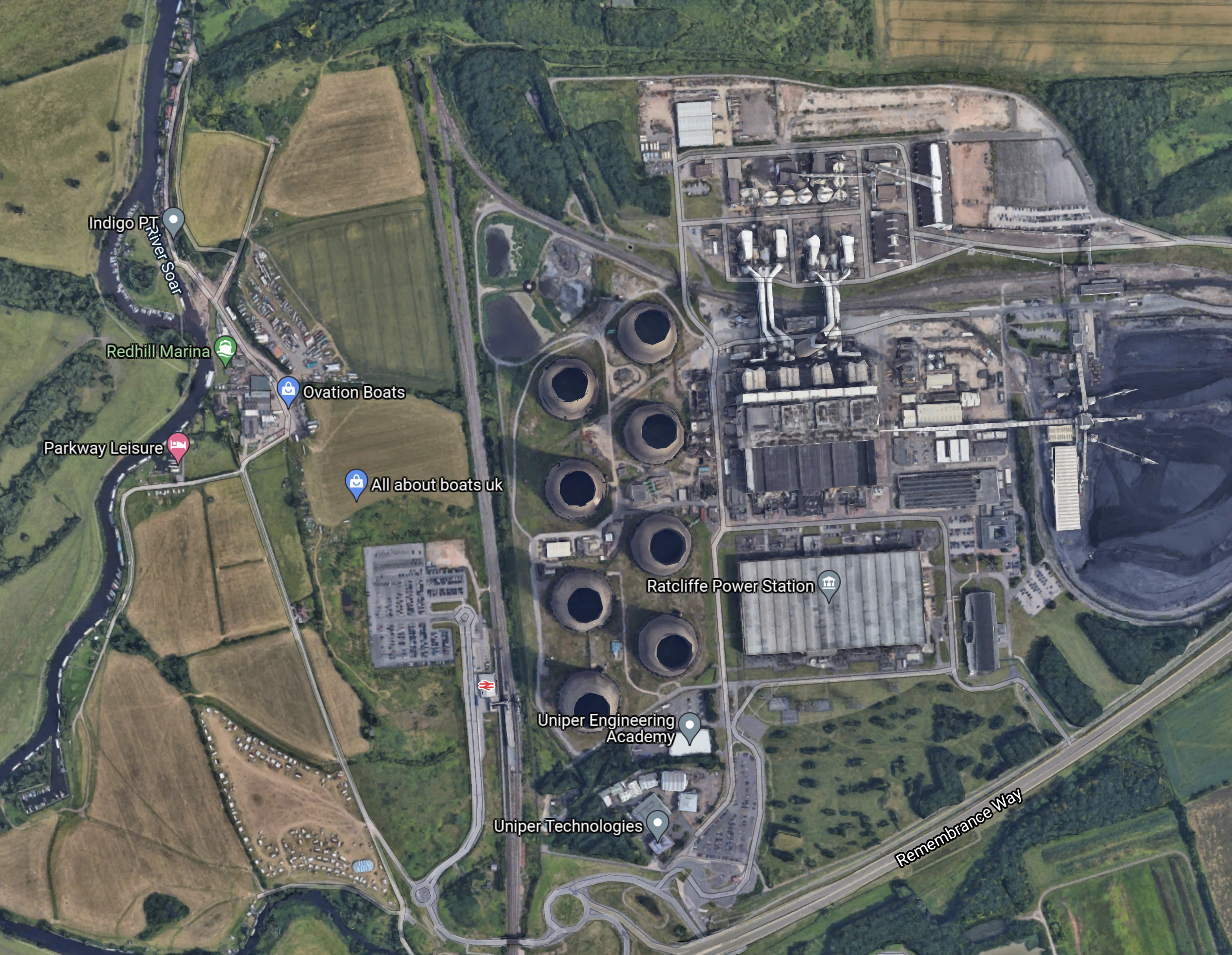
Some reports indicate that a new Birmingham and Nottingham High Speed Line will go via East Midland Parkway station.
- East Midland Parkway is a fully-functioning four-platform station.
- It is already operating.
- There will soon be a large brownfield site next door, when the coal-fired Radcliffe-on-Soar power-station is demolished.
- It has connections to Nottingham and Sheffield via Derby and Chesterfield.
- Platforms are probably long enough to handle splitting and joining.
- An advanced passenger shuttle could be built to East Midlands Airport.
This map from High Speed Two shows the route of the Eastern leg of High Speed Two, where it passes East Midland Parkway station and Radcliffe-on-Soar power-station.
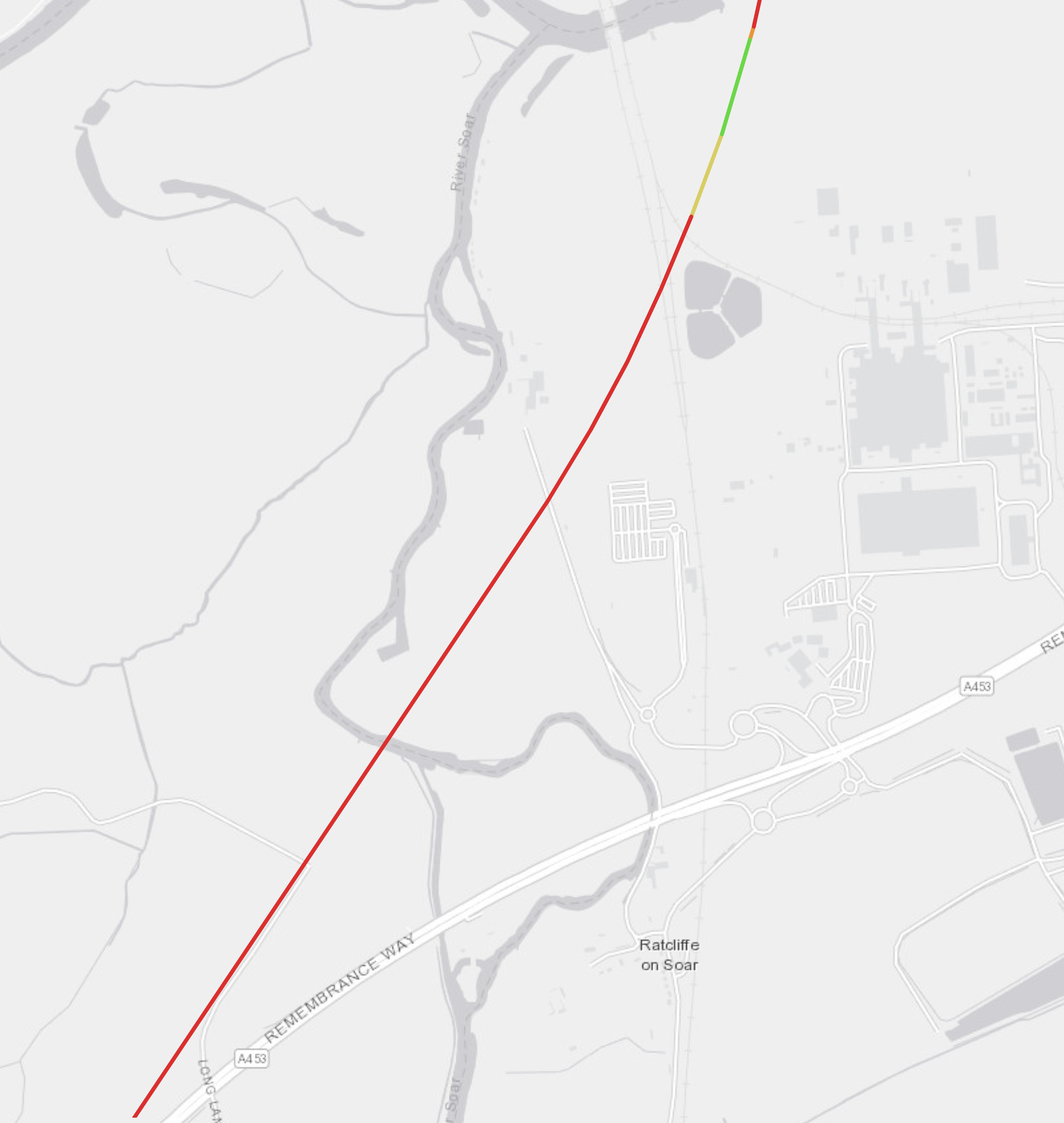
Note.
- The coloured line is the route of High Speed Two.
- Red indicates viaduct
- Yellow indicates cutting.
- Green indicates green tunnel.
- There is a curious clover-leaf shape to the East of High Speed Two.
This Google Map shows the same area.
Note
- The River Soar and Remembrance Way can be picked out on both maps.
- The Midland Main Line runs North-South in the Google Map and passes through East Midlands Parkway station.
- It is possible to pick out the curious clover leaf shape to the North of the railway station, where the rail line goes into the power station.
- Returning to the High Speed Two map it is possible to pick out the railway and power stations.
This map from High Speed Two shows the route of the Eastern leg of High Speed Two, to the South-West of East Midlands Parkway station.
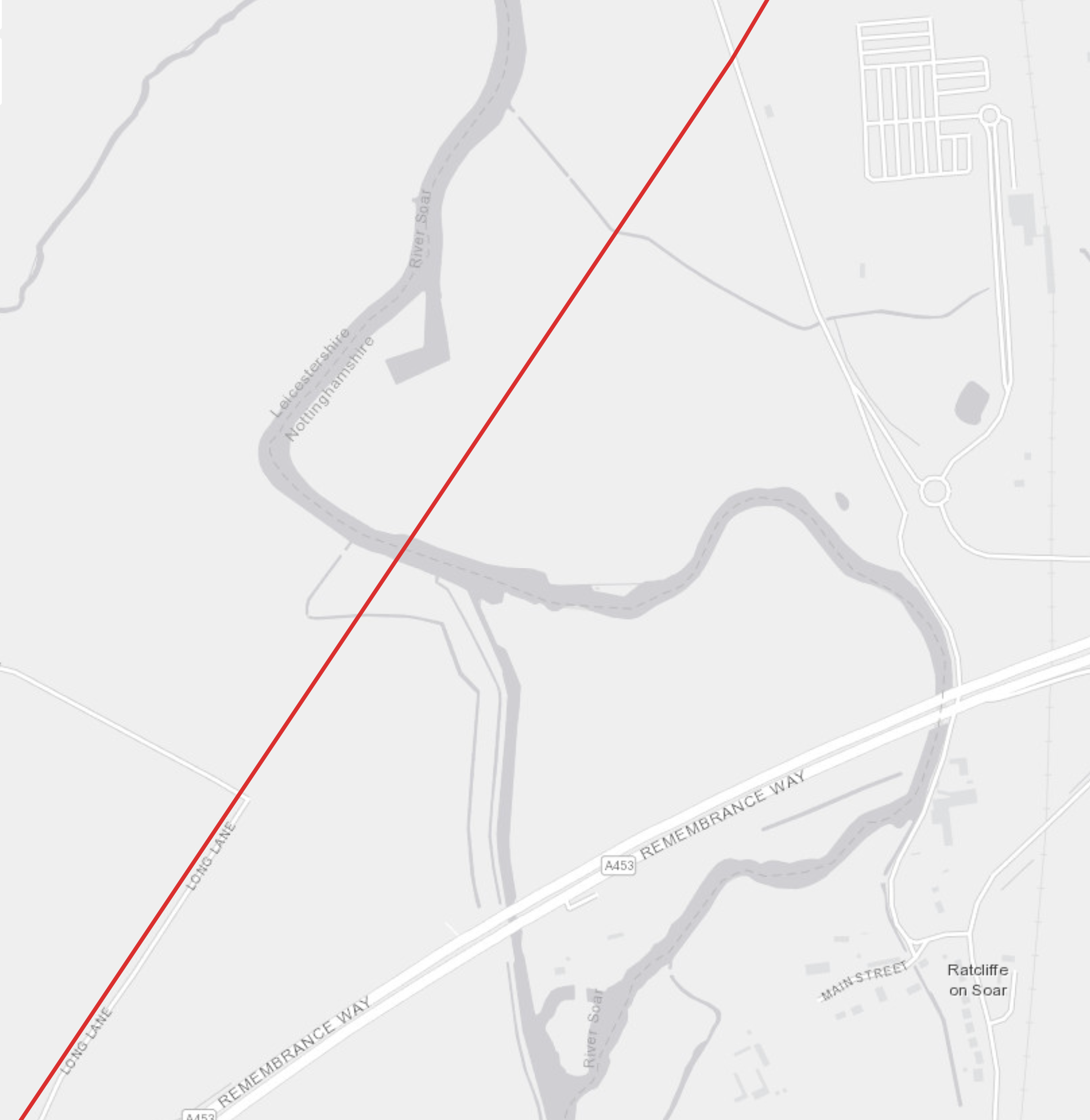
Note.
- The coloured line is the route of High Speed Two.
- Red indicates viaduct.
- East Midlands Parkway station is in the North-East corner of the map.
- The Midland Main Line runs North-South down the Eastern side of the map.
Could the route of High Speed Two be adjusted so that it runs through East Midlands Parkway station?
This Google Map shows a similar area as the second High Speed Two map.
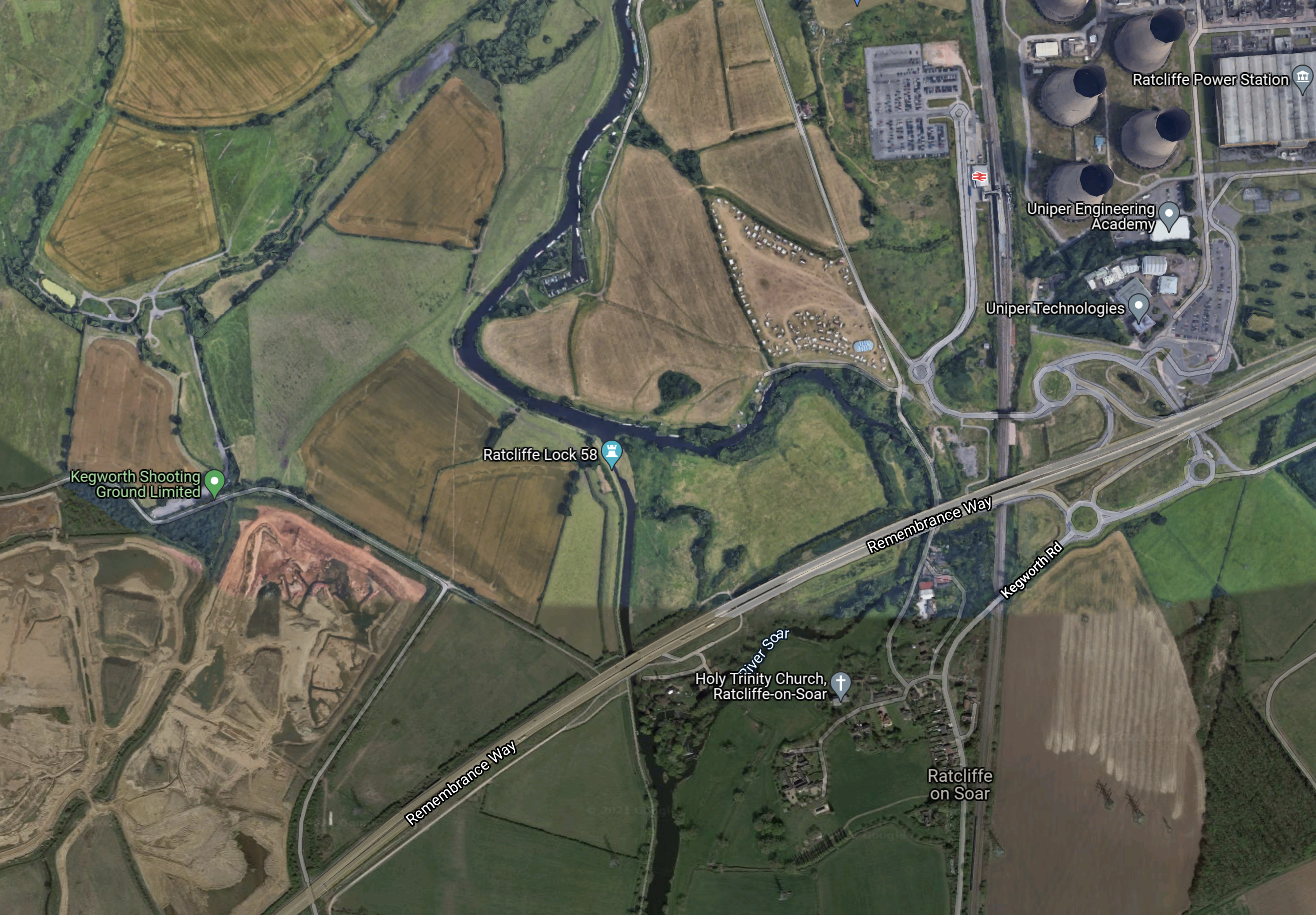
With the exception of the village of Radcliffe-on-Soar, there aren’t many, who would get in the way of the development of a connection between High Speed Two and the Midland Main Line to the South of East Midlands Parkway station.
- High Speed Two crosses Remembrance Way in the South West corner of the map, where there is a junction with the M1 and runs diagonally across the map.
- High Speed Two could probably sneak up the North side of Remembrance Way.
- The station might need to be moved to the North a bit to give space.
- The map also shows the space to the East, that will be created with the demolishing of the power station.
Developing East Midlands Parkway instead of East Midlands Hub could be the more affordable option.
High Speed Two’s Eastern Leg Services
This graphic shows High Speed Two’s services before the Eastern Leg was deleted.
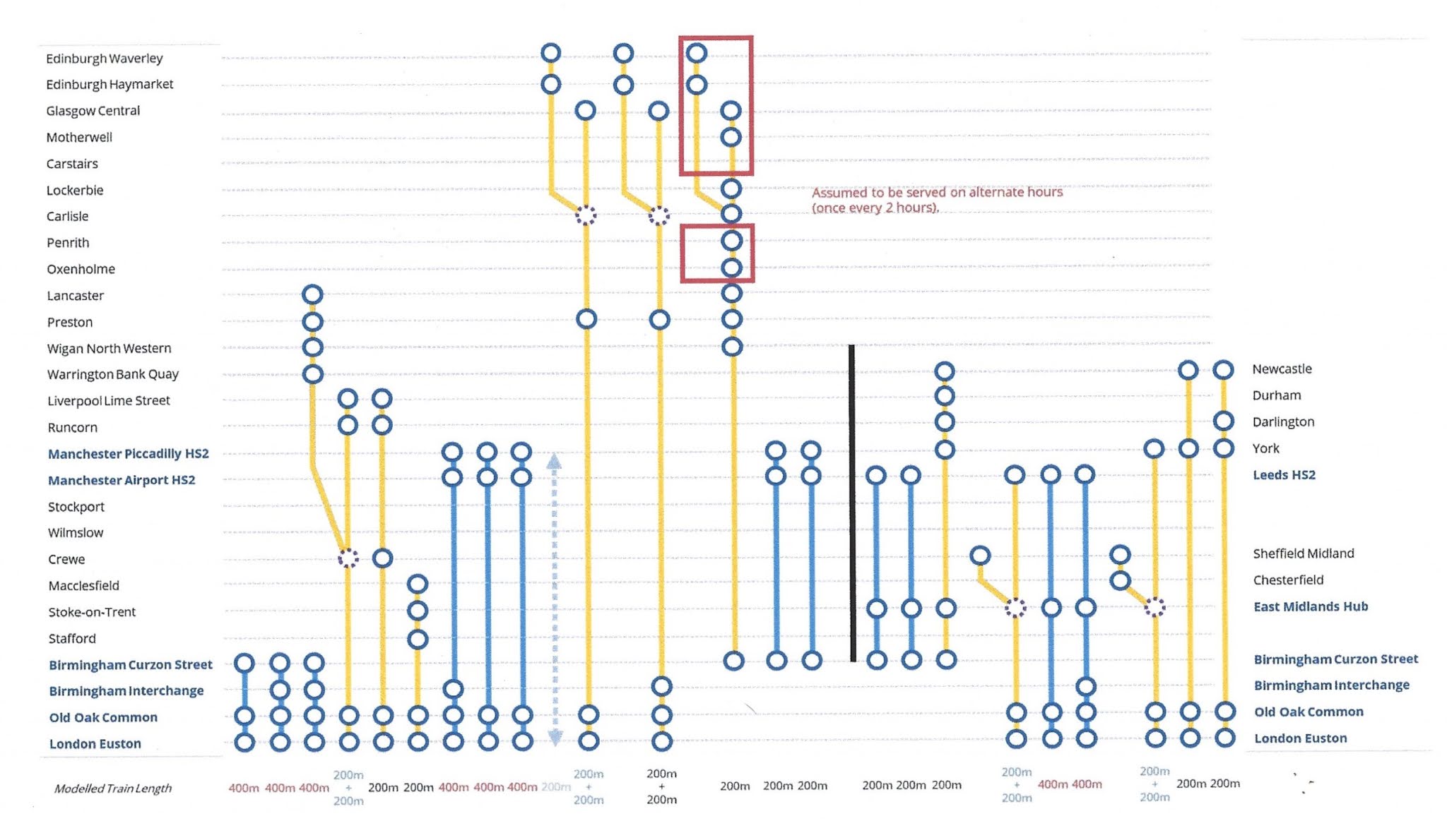
Note.
- Western Leg services are to the left of the vertical black line.
- Eastern Leg services are to the right of the vertical black line.
- Blue indicates a full-size service.
- Yellow indicates a Classic-Compatible service.
Destinations on the former Eastern Leg get the following services.
- Chesterfield – 1 tph
- Darlington – 2 tph
- Durham – 1 tph
- East Midlands Hub – 7 tph
- Leeds – 5 tph
- Newcastle – 3 tph
- Sheffield – 2 tph
- York – 6 tph
Note.
- Two trains will split and join at East Midlands Hub or East Midlands Parkway. But given what I said earlier, the split will take place at East Midlands Parkway.
- Derby, Chesterfield and Sheffield could get two tph.
- If the pattern of the currently proposed High Speed Two service is followed, that would mean that 5tph to Leeds and four tph to York and further North would go through Nottingham.
I suspect that there could be a reduction in either High Speed Services on the Eastern Leg or on the East Coast Main Line.
Splitting And Joining At East Midlands Parkway
Consider.
- All Northbound services on High Speed Two and the Midland Main Line pass through East Midlands Parkway station in the same direction.
- All Southbound services on High Speed Two and the Midland Main Line pass through East Midlands Parkway station in the same direction.
- The four platforms at East Midlands Parkway station will give a lot of flexibility.
If trains split and joined at East Midlands Parkway, there would be no need to reverse to serve Derby, Chesterfield and Sheffield. I can’t see how this could be performed at East Midlands Hub without the Sheffield train reversing. This probably explains why in the original plans for High Speed Two, Sheffield and Chesterfield had their own spur and Derby was not served directly by High Speed Two.
The redesign in the Integrated Rail Plan For The North And Midlands, which abandons the Sheffield spur, probably reduces the costs significantly.
Nottingham
Nottingham will be an extremely busy station with these services running through.
- High Speed Two – 2 tph – Birmingham Curzon Street and Leeds HS2 via Nottingham – Full-Size – 200 metres
- High Speed Two – 1 tph – Birmingham Curzon Street and Newcastle via Nottingham, York, Darlington and Durham – Classic-Compatible – 200 metres
- High Speed Two – 1 tph – London and Leeds HS2 via Nottingham – Classic-Compatible – 200 metres
- High Speed Two – 1 tph – London and Leeds HS2 via Nottingham – Full-Size – 400 metres
- High Speed Two – 1 tph – London and Leeds HS2 via Birmingham Interchange and Nottingham – Full-Size – 400 metres
- High Speed Two – 1 tph – London and York via Nottingham – Classic-Compatible – 200 metres
- High Speed Two – 1 tph – London and Newcastle via Nottingham and York – Classic-Compatible – 200 metres
- High Speed Two – 1 tph – London and Newcastle via Nottingham, York and Darlington – Classic-Compatible – 200 metres
- East Midlands Railway – 1 tph – London St. Pancras and Nottingham via Kettering, Market Harborough and Leicester – Class 810
- East Midlands Railway – 1 tph – London St. Pancras and Nottingham via Kettering, Market Harborough, Leicester, Loughborough, East Midlands Parkway and Beeston – Class 810
- East Midlands Railway – 1 tph – Liverpool Lime Street and Norwich via Chesterfield, Alfreton, Nottingham, Grantham, Peterborough and several other stations – Class 158/170
- East Midlands Railway – 1 tph – Crewe and Newark Castle via Nottingham and several other stations – Class 158/170
- East Midlands Railway – 1 tph – Leicester and Lincoln via East Midlands Parkway, Attenborough, Beeston, Nottingham, Carlton and several other stations – Class 158/170
- CrossCountry – 1 tph – Cardiff Central and Nottingham via Derby, Spondon, Long Eaton, Beeston and several other stations – Class 170
- CrossCountry – 1 tph – Birmingham New Street and Nottingham via Derby – Class 170
- Midlands Connect – 1 tph – Leeds and Bedford via Nottingham and Leicester – Classic-Compatible – 200 metres
Note.
- With High Speed Two services London means London Euston and Old Oak Common.
- Two High Speed Two services do not stop in Nottingham
- With several of these routes I have only put in a few intermediate stations to show the routing of the train at Nottingham.
These services total up to twelve tph going through Nottingham and four tph terminating at Nottingham from London St. Pancras and Birmingham New Street.
Nottingham station would need to be able to handle the following with respect to through trains.
- A train every five minutes.
- Some trains would be 400 metres long.
But there is plenty of space in Nottingham station and High Speed Two’s digital signalling will be able to handle 18 tph.
Nottingham And Newark
The Nottingham and Lincoln Line between Nottingham and Newark appears from my helicopter to be fairly straight.
- The line is double track.
- There are eight stations between Nottingham and the East Coast Main Line.
- The maximum speed of the line is 70 mph.
- It is 18.1 miles between Nottingham and the East Coast Main Line.
- I suspect that it could be upgraded to a 100 mph between Nottingham and the East Coast Main Line.
Typical services in tph will be the same as at Nottingham, which is 12 tph. But there are also occasional freight trains and Peak services to and from London St. Pancras.
With digital signalling on this relatively-simple section, if it were to be fitted with High Speed Two digital signalling, that will have to be able to handle 18 tph, what would you do with the other six tph?
- Some paths would be used to handle the occasional freight trains and Peak services to and from London St. Pancras.
- Some of the capacity could also be used by the stopping trains.
The amount of traffic would probably be less than on the Great Eastern Main Line, which is capable of 100 mph running.
Newark
Newark has the notorious flat crossing, where the Nottingham and Lincoln Line crosses the East Coast Main Line.
This Google Map shows the track layout at Newark.
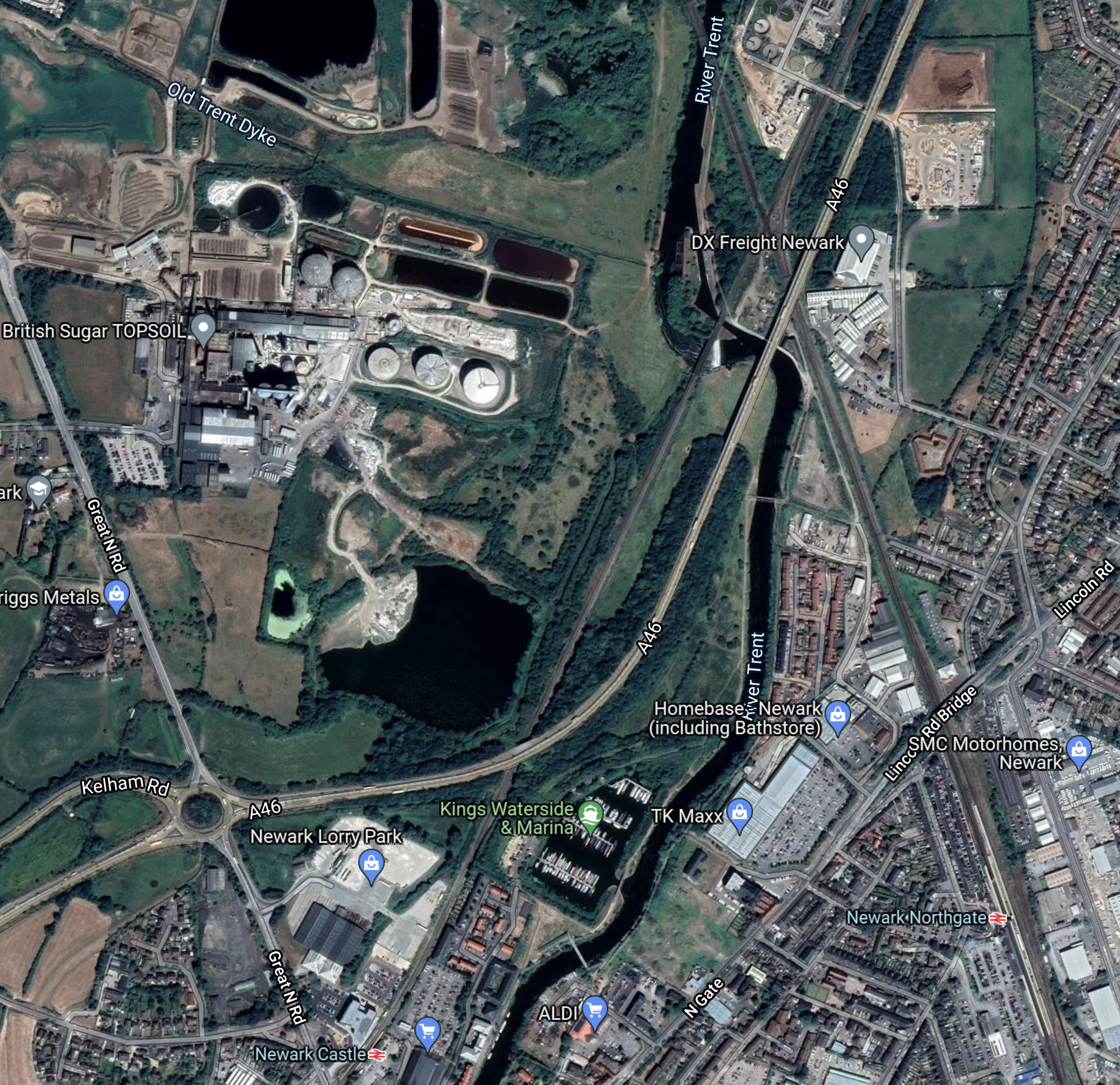
Note.
- Newark Castle station is on the Nottingham and Lincoln Line and is in the South-West corner of the map.
- Newark North Gate station is on the East Coast Main Line and is in the South-East corner of the map.
- The two rail lines run diagonally across the map and cross near the top of the map towards the right.
- Nottingham lies in a South-Westerly direction from this map.
- Lincoln lies in a North-Easterly direction from this map.
- Doncaster, Leeds and York lie in a North-Westerly direction from this map.
- Grantham, Peterborough and London lie in a South-Easterly direction from this map.
Under the Greengauge 21 plan, trains will need to run in the following directions.
- In both directions on the East Coast Main Line.
- In both directions on the Nottingham and Lincoln Line.
- Coming South on the East Coast Main Line, trains will need to be able to go towards Nottingham on the Notting and Lincoln Line.
- Coming from Nottingham on the Nottingham and Lincoln Line, trains will need to be able to go Leeds and York on the East Coast Main Line.
It would be a complicated set of junctions and flyovers for a railway, but not impossible to design and build.
Newark North Gate And Colton Junction
I’ll repeat the map I showed earlier, that shows the routes between Newark North Gate and Colton Junction.
Note.
- The current East Coast Main Line via Doncaster is shown dotted in black.
- The proposed new route, which is called HS3 is shown in white.
- Colton Junction is at the Northern end of the new track.
I suspect that the new route would be built to the same operating standards as High Speed Two.
- Operating speed of 205 mph.
- High specification electrification.
- Signalling capable of handling 18 tph.
- All classic and Classic-Compatible high speed trains would be able to take both routes, but would be limited to 125 mph or 140 mph with in-cab digital signalling on the East Coast Main Line.
- Trains needing to call at Doncaster and freight trains, would use the East Coast Main Line.
- Full-Size High Speed Two trains would generally use the new high speed line.
It looks to be a good way to increase capacity between Newark and Leeds and York.
Timings Between Newark North Gate And Colton Junction
Consider.
- Newark North Gate and Colton Junction are 63 miles apart.
- Trains take 39 minutes.
- There is a stop at Doncaster.
This is an average speed of 97 mph.
If trains went non-stop on the new ‘HS3’ route, there would be these timings at different average speeds.
- 100 mph – 37.8 minutes
- 125 mph – 30.2 minutes
- 140 mph – 27 minutes
- 160 mph – 23.6 minutes
- 180 mph – 22.2 minutes
- 200 mph – 18.9 minutes
Note.
- I have assumed the distance is the same as via the East Coast Main Line.
- I have made no allowance for longer acceleration and deceleration times to and from higher line speeds.
- High Speed Two Classic Compatible Trains could handle up to 205 mph if the track could support it.
It does appear that savings of upwards of fifteen minutes could be possible on all services that could use the new route.
Both East Coast Main Line and High Speed Two services would get time savings.
Colton Junction And York
As I saw and wrote about in London To Edinburgh On Lumo, the route between Leeds and York is being fully electrified.
The East Coast Main Line is already fully electrified, so I doubt the connection between ‘HS3’ and York will be difficult.
Trains will just exchange a 205 mph track for the East Coast Main Line’s 125 mph or 140 mph with in-cab digital signalling.
Colton Junction And Leeds
This High Speed Two Map shows the original planned track layout for High Speed Two to the East of Leeds.
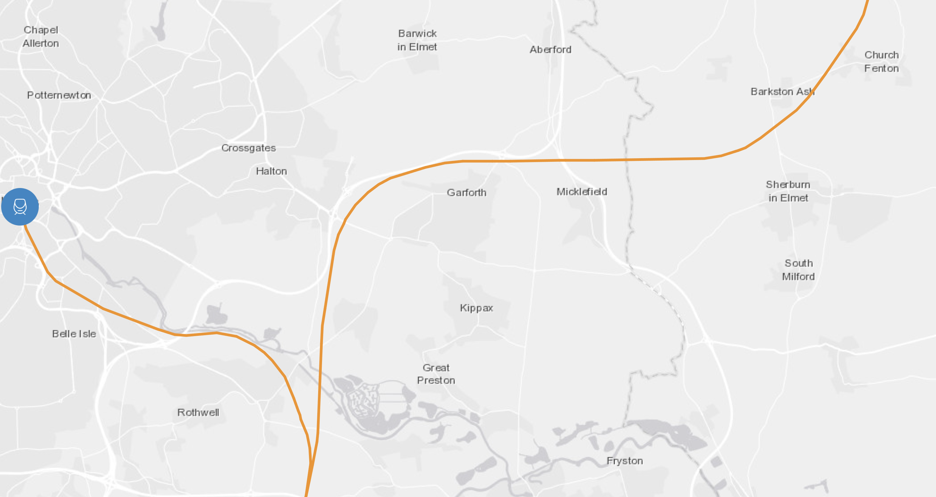
Note.
- The large blue dot indicates Leeds HS2 station.
- The orange lines indicate the new high speed tracks for High Speed Two.
- The track going North-East is High Speed Two’s connection to the East Coast Main Line in the area of Colton Junction.
- The track going South is the Eastern Leg of High Speed Two to East Midlands Hub station, which has now been deleted.
Would it be possible to modify the route of High Speed Two to create a link between the Norther end of Newark and Colton Junction High Speed Line, which Greengauge 21 called HS3 and the proposed Leeds HS2 station?
This map from High Speed Two shows the area, where the High Speed Two Lines were originally proposed to run.

Note.
- The village of Swillington to the East of the proposed route of the Eastern Leg of High Speed Two.
- Junction 45 of the M1 in the North-West corner of the map.
- The River Aire and the Aire and Calder Navigation Canal on the route of High Speed Two to Leeds HS2 station.
This Google Map shows the same area.
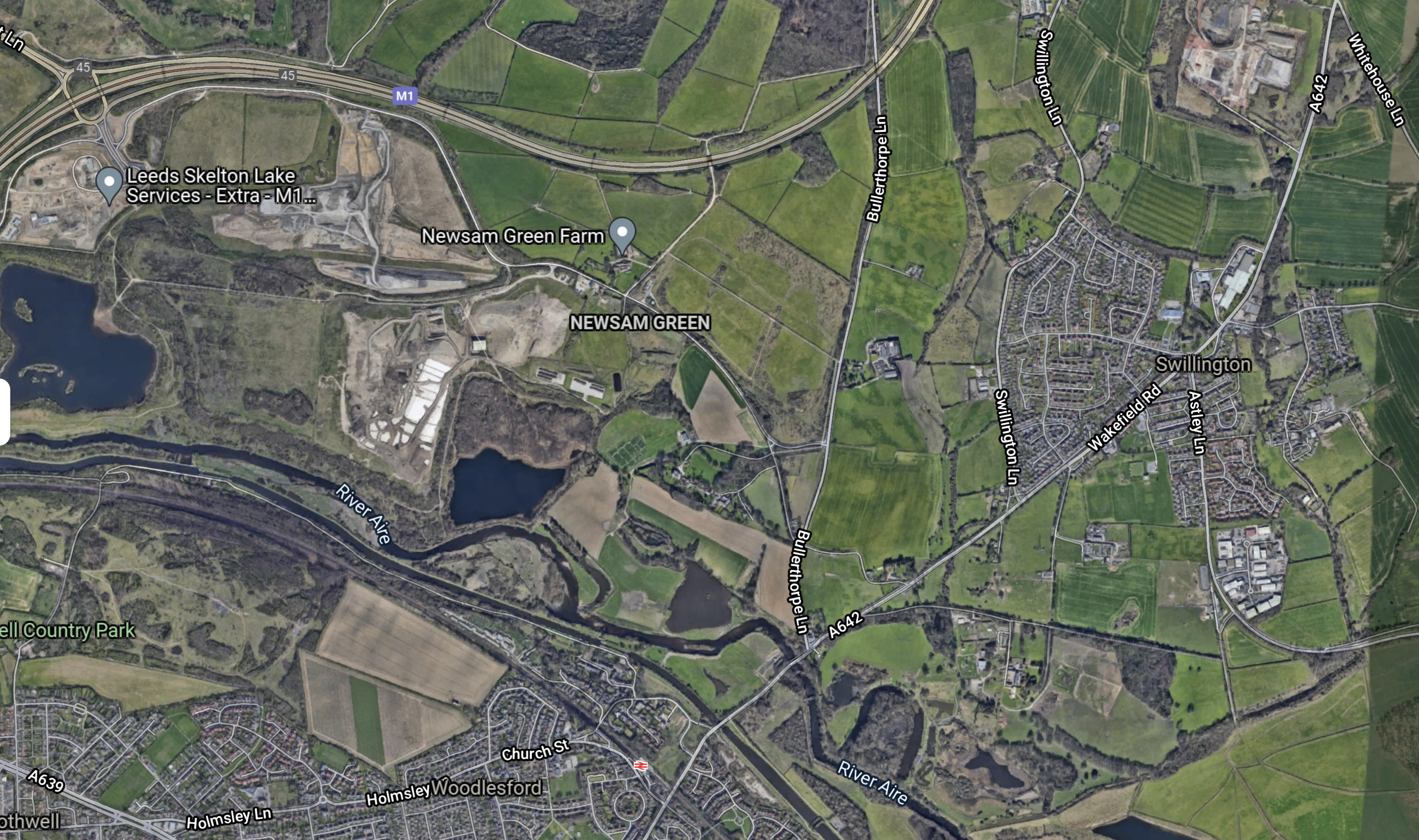
I’m no expert, but I do believe that it would be possible to create a chord to allow trains to access Leeds HS2 station from the York direction.
I would suspect that High Speed Two looked seriously at this chord, as it would enable the proposed Leeds HS2 station to have services to York, Newcastle and Edinburgh using the East Coast Main Line.
But there is one problem with this route – It doesn’t allow and easy solution to serve Bradford.
This map from High Speed Two, shows the Leeds HS2 station and the last bit of the approach from the East.
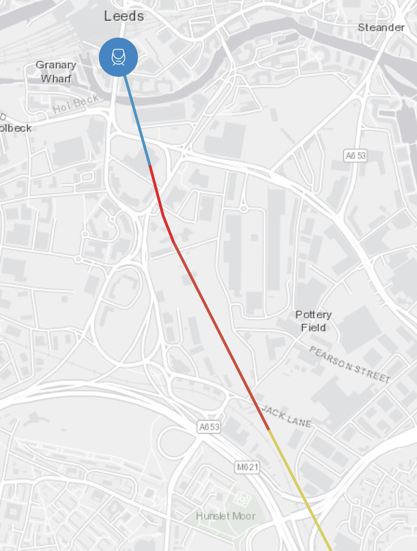
This article on the Architects Journal is entitled Foster + Partners behind designs for Leeds HS2 Station. The article shows.
- Leeds HS2 station is being designed as a terminal station.
- It shares a common concourse with the current Leeds station.
It appears from the pictures in the Architects Journal article, that passengers would have to change trains to get to Bradford.
The alternative would be for trains into Leeds to take the route used by Northern’s service between York and Blackpool North, which goes via Church Fenton, Micklefield, East Garforth, Garforth, Leeds, Bramley, New Pudsey and Bradford Interchange.
But judging by the times of other services, Colton Junction and Leeds would take over twenty minutes and it would be a further twenty minutes to Bradford Interchange.
I can’t think that this is a viable alternative.
Conclusion
I am led to the conclusion, that to get a decent service into Leeds from the East using Greengaige 21’s ‘HS3’ between Newark and Colton junction, would necessitate the building of a new Leeds HS2 station and a new route between the new station and Colton junction.
Eight New Freeports Set To Open In The UK
Today, in his 2021 Budget, Rishi Sunak announced eight new freeports.
This article on the BBC, which is entitled Freeports: What Are They And Where Will They Be?, gives a brief guide to the freeports.
This links link to the nearest I can find to an official web site for each of the freeports.
The Government has said that the freeports will start their operations late this year.
East Midlands Airport Offers £2.5m Fund To Boost Station Connections
The title of this post is the same as an article on Rail Technology Magazine.
If not desperation, there is an air of We Must Do Better about the title.
So I went to the Rail page on the EastMidlands Airport web site.
This is said.
With a choice of stations, it’s never been easier to travel by train to East Midlands Airport. Connections are available to the north and south of the country from Derby, Nottingham and Long Eaton, with bus services to each station possible through regular Skylink bus services to and from the airport.
It is possible to connect at East Midlands Parkway for journeys to and from destinations outside the East Midlands region. This station is now served by a Parkway Railink – a scheduled 6-seater operating every day from 6am to 7pm hourly.
I certainly haven’t seen many airports with worse rail access than that, so I can understand their £2.5million offer.
Their demands outlined in Rail Technology Magazine aren’t unreasonable, but they are short of direct access.
This Google Map shows East Midlands Airport.
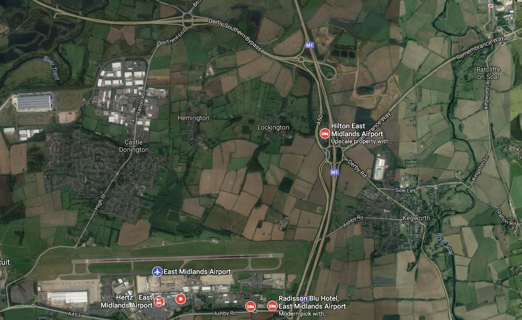
Note East Midlands Parkway station is in the North-East corner of the map.
Note that the runway at the airport is 2,893 metres long.
I think it’s true to say, unless your destination could only be reached from East Midlands Airport, those without cars, wouldn’t go near the place.
