Lost In Clapham
Yesterday, I had to deliver something to an address in Battersea. I found the address easily after taking a 35 bus to just round the corner. But then I tried to walk through the area to Clapham Junction station to get the Overground home. There were none of the usual bus stop maps and no Legible London signs.

A Useless Bus Stop
The picture shows a typical bus stop on I think Lavender Hill. It may have had an information display, but that is not very useful, if you don’t know the routes of the buses.
I should say that I did see several night bus route maps, but I wanted to get home now, not wait until late at night.
In the end I took the first bus and got off, when it told me it was at Wandsworth Road station. I finally found a lone Legible London lith.

A Solitary Lith
But it was unnecessary for me, as I had arrived at a station, where I could get a train home.
Perhaps people only go to South London to get lost.
Walking In Birmingham
I knew where I was going today, as I was going to Carluccio’s in Brindley Place. The new station entrances actually made it easier, as it seemed to me, that there wasn’t such an uphill climb, as the station seemed to slope in the right direction.
But I didn’t see a map anywhere! So if you are a first time visitor, what do you do? I know the station isn’t complete but surely in the main shopping centre, there should be something to help, non-Brummies! i suppose in some ways, you get spoilt in London, which can be almost over-mapped at times.
I have also started to not where a watch, as it irritates my arm and shoulder. And I didn’t see a clock anywhere!
Birmingham needs to implement its own version of Legible London.
But like two door buses, most cities don’t like to even trial something that works well in London.
No Maps At Hamburg Station
There were no maps at Hamburg station. But there were cigarette adverts.

No Maps At Hamburg Station
In fact, there were cigarette adverts all over the city.
Welcome To Stockholm
I took the train into Stockholm from the airport at Arlanda and then walked to the hotel. I know cycling is good for you, but why do cyclists park their bikes everywhere, so that walking is virtually impossible?

Welcome To Stockholm
In fairness to Stockholm, a lot of building work was going on at the station and the walking path will probably be better in the future. There was the odd map along the route, but not as many as we now have in London. But some might say that London is overmapped. I wouldn’t!
A Visit To The World’s Best Therapist
I had a bit of a shock this morning, as the news said that somebody I might know had died in tragic circumstances.
So I decided that I needed to explore some parts of the London Underground. I intended to have breakfast at Leon in Kings Cross station and then I intended to see if I could find the Underground maps in Lego.
I then visited all the maps before I finished up at Stratford, from where I took the Overground home.
As I often do, I met some interesting people, including a young lady accompanied by her charming baby, who with her partner had taken a train all the way back from Istanbul and soon were going to Denmark overland. Where do I find a lady of a compatible age to myself, who likes trains, architecture and football? Especially, to accompany me to Odessa to see the Potemkin Steps, watch England in Kiev and then come home via Warsaw and Berlin.
i certainly felt a lot better, as I say down to watch the cricket. But I still don’t know if I knew the person, who died.
Chaos At Richmond
The reception was at Ham House and to get there the Transport for London journey planner, said go to Richmond Station and then get a 371 bus from stop E to Ham Street and walk.
Unfortunately, the finding of a 371 bus wasn’t easy, as south West Trains didn’t seem to have provided any of TfL’s useful bus spider maps at the station. So I couldn’t locate stop E. as I was early, I had a tea in the Carluccio’s by the station and the waitress told me that I got the bus to Ham House from outside the station.
So I got the 371 bus, when it turned up a few minutes later, at the temporary stop, which partly explained my problem. But I didn’t find a bus route map anywhere.
It is an area I don’t know well and it didn’t help that the information system on the bus wasn’t working. But I got there without delay.
Coming back, I was a bit worried about buses late at night, but the stop was covered by the SMS message system that tracks most of London’s buses and I got back home without further trouble.
Checking this morning, it would appear that the 371 actually starts now from stop D at Richmond, so TfL has got a touch of the misinformations.
Busways And Sat-Navs Don’t Mix
This story from Cambridge on the BBC’s web site, shows an idiot, who got his lorry onto the Cambridge Busway.
The driver is apparently blaming his sat-nav. It should be part of the driving test and especially for those, who drive heavy lorries, that you have the ability to read a map and road signs.
On the subject of sat-navs, some couriers and others seem to have difficulty finding my house using them, as they get directed round the back to the mews. So in this case, it probably isn’t the sat-nav, but the data it’s loaded with.
Reading’s Style Before Substance Maps
On my trip today, I’d planned to have lunch in Carluccio’s, so before I left, I looked up the address and the walking route from Reading station.
So after taking the photos of the station, I walked into the town centre and traced the way my mind told me to go. I had hoped to get help from a map, but all I had were ones like this.
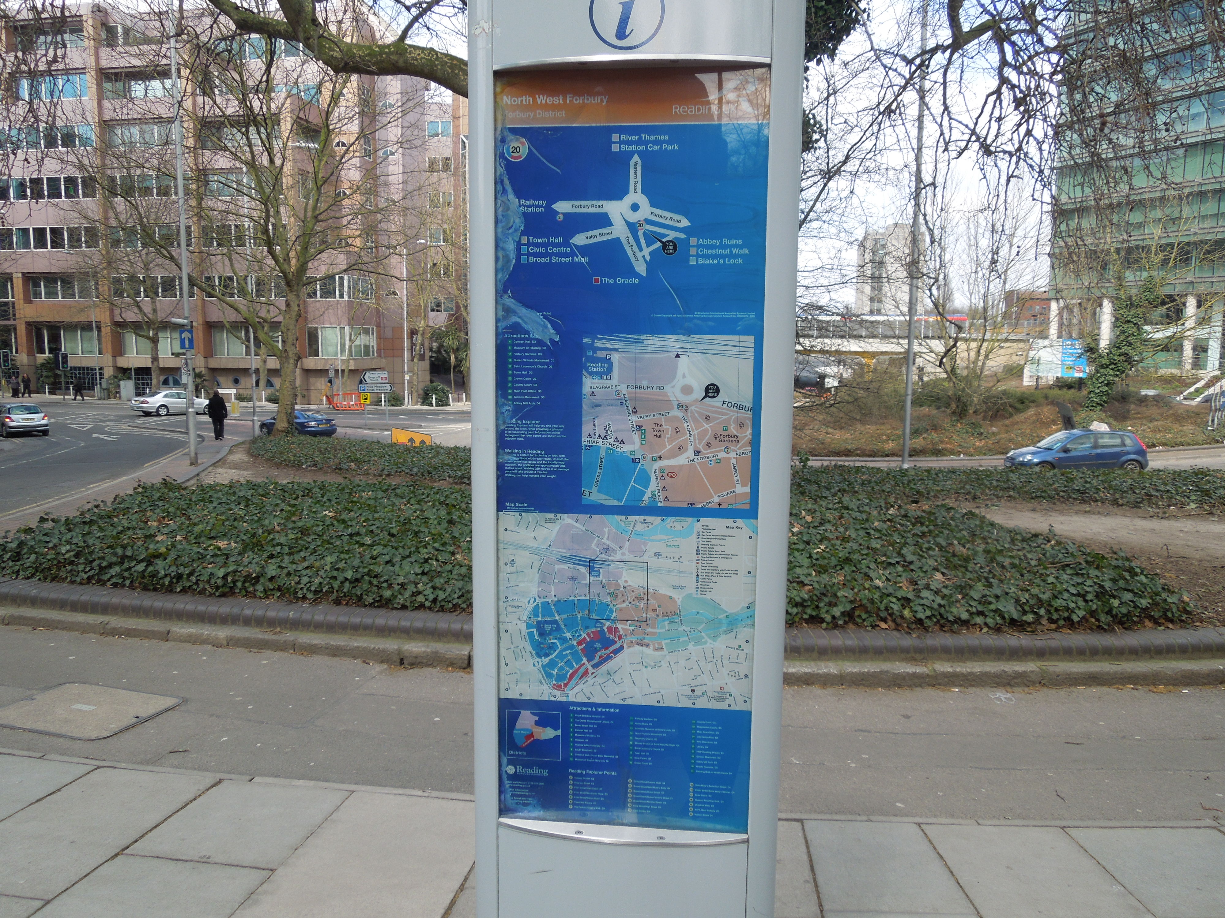
Reading’s Style Before Substance Maps
Stylish they may be, but they aren’t the best, if you want to find a street, you’ve looked up previously, as there isn’t enough detail and no street index.
Luckily in the end, I found a local who knew where Carluccio’s was and I walked there and had an excellent lunch.
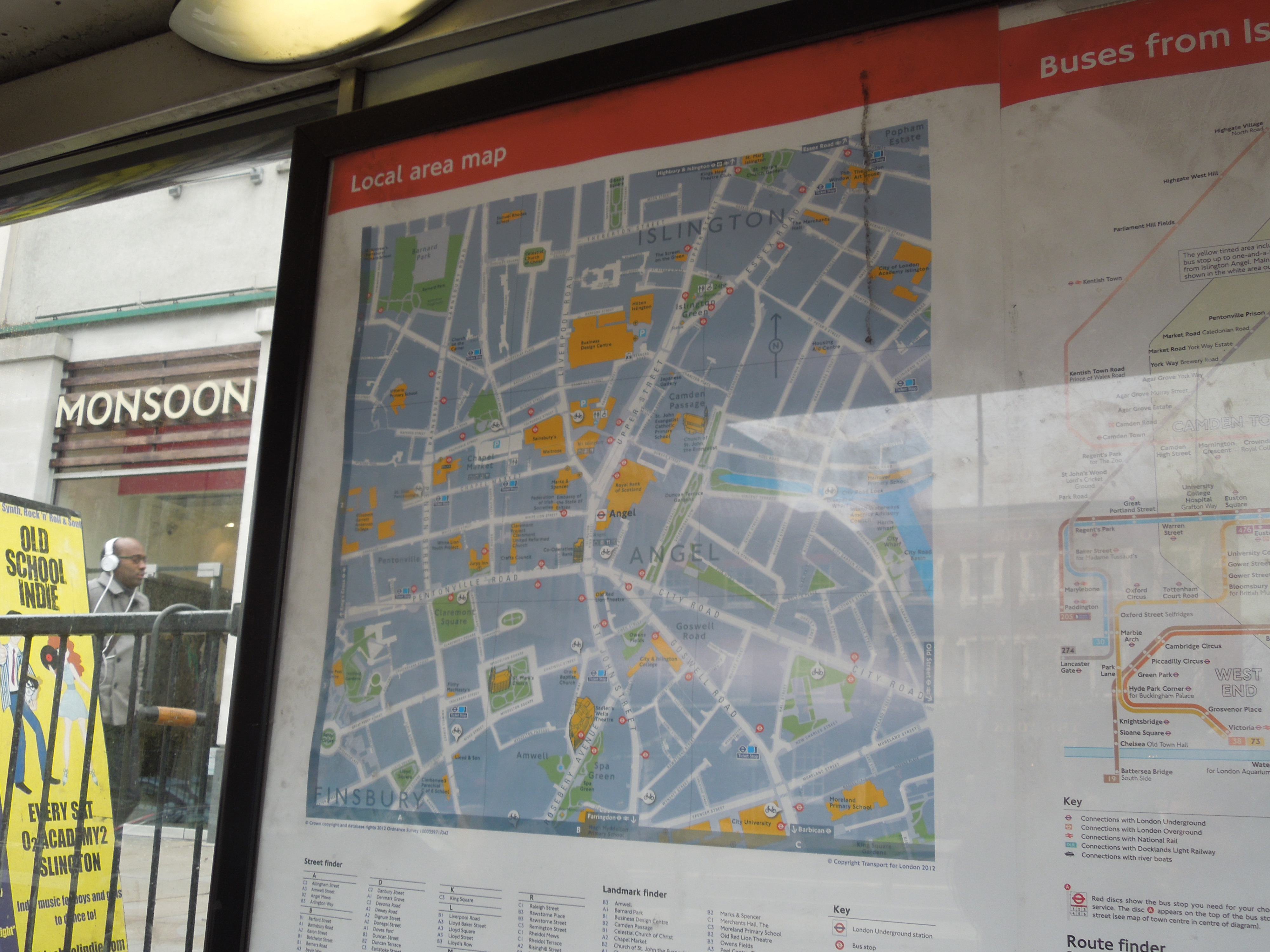
Londoners like me, are very used to good maps, as I can always remember them from my childhood, when every Tube station had a local map. Now every bus stop does, like this one at the Angel.
Local Street Map At The Angel
At the Angel too, there are also informational maps of the area, with all of the major buildings and landmarks indicated.
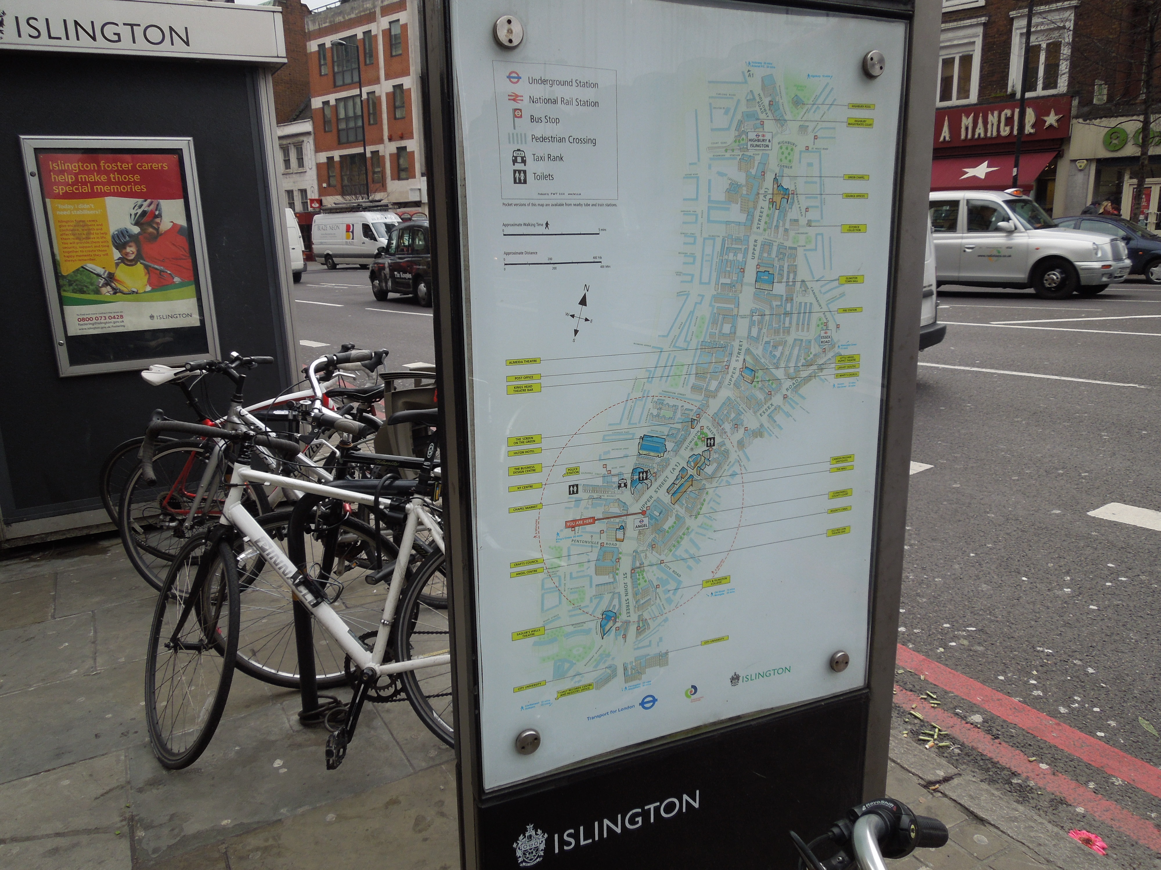
informational Map At The Angel
Reading’s maps may be stylish, but they are useless if you’re not a local and don’t use a smart phone.
But say you want to find Carluccio’s at Islington, you would just say
The restaurant is by St. Mary’s Church, opposite the Almeida Theatre.
Both places are mentioned on Islington’s informational map.
Perhaps the maps in Reading, were designed, by trendy smart phone freaks, who don’t realise how a lot of people think and operate.
The problem was made worse at Reading, because there was no local information or map at the station. This was probably due to the rebuilding. I didn’t even notice the finger posts, I saw the last time I was in the town. Have they been replaced by the maps?
The Best Of British In Gibraltar
Gibraltar has lots of things that we would recognise as some of the best of British icons, standards and design.


I also liked the main shopping street, which was tidy and neat and reminded me of some of those shopping centres in seaside towns. It was even a bit like how I remember Hamilton Road in Felixstowe in the 1960s.
It was certainly, a well signposted place and I must have counted six or more of the large street maps. To contrast, I’ve never seen one in Blackpool.
The Royal Gibraltar Police incidentally, are the second oldest force in the Commonwealth.
