Repurposing The Great Glen Hydro-Electric Scheme
The Great Glen hydro-electric scheme was built in the 1950s and early 1960s, by the North of Scotland Hydroelectric Board.
- The scheme is now owned by SSE Renewables and has a page on their web site.
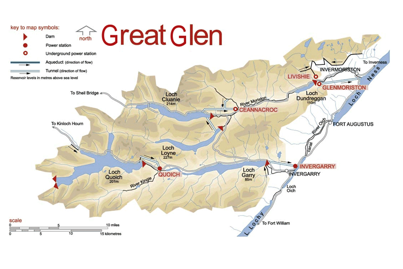
- There are six individual power stations; Ceannacroc, Livishie, Glenmoriston, Quoich, Invergarry and Mucomir.
- There are five dams; Cluanie, Loyne, Dundreggan, Quoich and Invergarry.
This map from the SSE Renewables web site shows the layout of the dams and power stations.
The sizes of the power stations in the scheme are as follows.
- Ceannacroc – 20 MW
- Livishie – 15 MW
- Glenmoriston- 37 MW
- Quoich – 18 MW
- Invergarry – 20 MW
- Mucomir – 1.7 MW
This gives a total power of 112.7 MW.
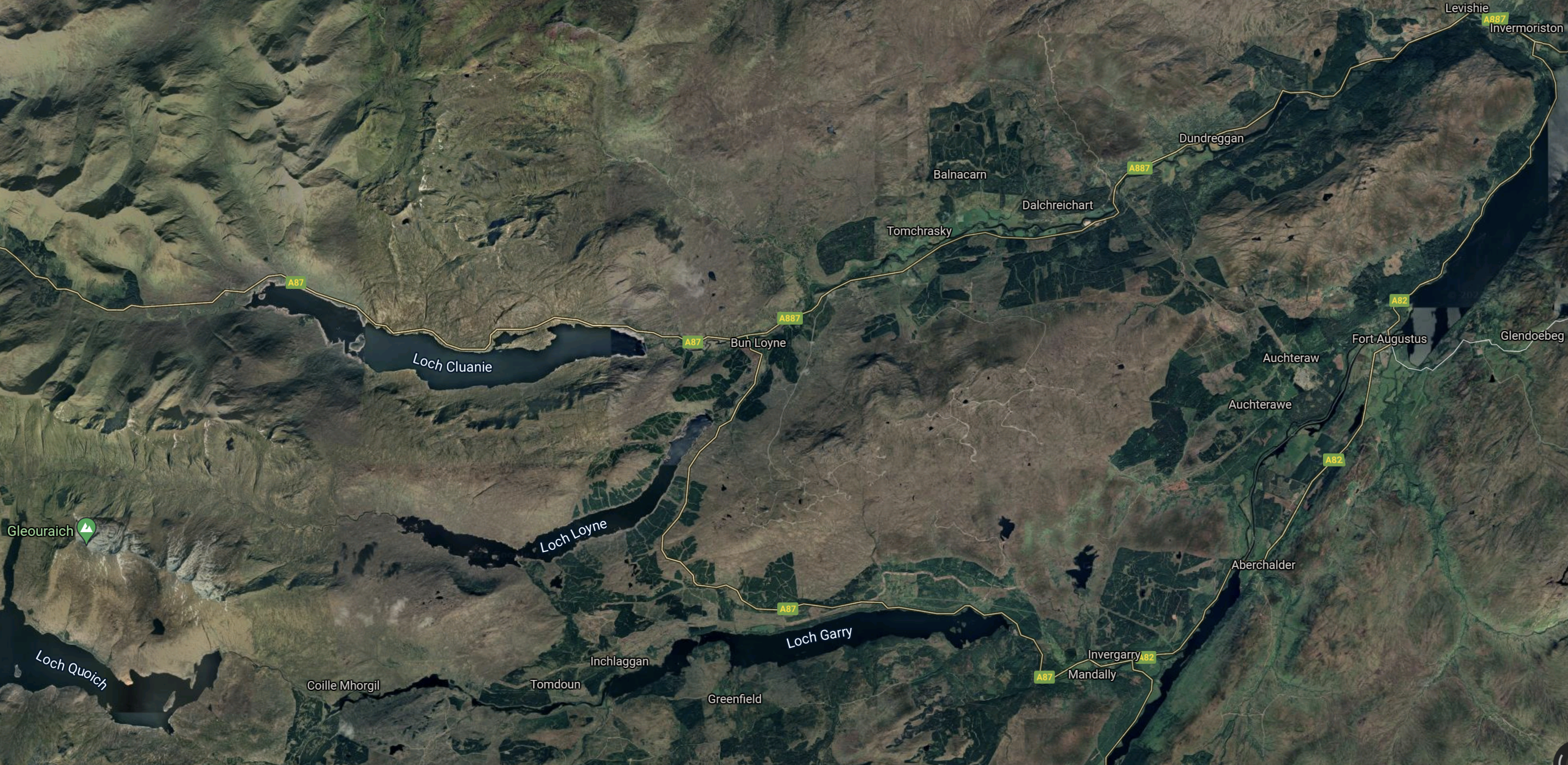
This Google Map shows the same area as the SSE Renewables Map.
Note.
- Loch Quoich is in the South-West corner.
- To the East of Loch Quoich is Loch Garry and to the North-East is Loch Loyne.
- Loch Cluanie is to the North.
- Invermoriston is in the North-East corner.
The scheme also includes three underground power stations and several miles of tunnels.
Strathclyde University And Pumped Storage Power For Scotland
This page on the Strathclyde University gives a list of the pumped storage potential for Scottish hydrogen-electric dams and power stations.
These figures are given for the dams and lochs in the Great Glen scheme.
- Invergarry – 22 GWh
- Glenmoriston- 41 GWh
- Quoich – 27 GWh
It would appear that based on research from Strathclyde University, that the Great Glen scheme could support up to 90 GWh of pumped storage.
Water Flows In The Great Glen Scheme
Looking at the SSE Renewables map of the Great Glen scheme, water flows appear to be as follows.
- Loch Quoich to Loch Garry via Quoich power station.
- Loch Garry to Loch Oich via Invergarry power station.
- Loch Loyne to Loch Dundreggan via River Moriston.
- Loch Cluanie to Loch Dundreggan via Ceannacroc power station and River Moriston.
- Loch Dundreggan to Loch Ness via Glenmoriston power station.
All the water eventually flows into the sea at Inverness.
Refurbishing And Repurposing The Great Glen Scheme
Perhaps as the power stations are now over fifty years old, one simple way to increase the generating capacity of the Great Glen scheme, might be to selectively replace the turbines, with modern turbines, that can generate electricity more efficiently.
I suspect that SSE Renewables have an ongoing program of improvements and replacements for all of their hydro-electric stations in Scotland. Some turbines at Sloy power station have already been replaced with larger ones.
Adding Pumped Storage To The Great Glen Scheme
I would assume that the water to pump uphill at night or when there is a surplus of electricity will come from Loch Oich or Loch Ness.
Some power stations like Glenmoriston and Invergarry might be updated to both generate electricity or pump water up hill, as is required.
Conclusion
There would appear to be up to three schemes, that could each add around 30 GWh of pumped storage.
One advantage is that the waters of Loch Ness can be used for the lower reservoir.
Repurposing The Affric/Beauly Hydro-Electric Scheme
The Affric/Beauly hydro-electric scheme was built in the 1950s and early 1960s, by the North of Scotland Hydroelectric Board.
- The scheme is now owned by SSE Renewables and has a page on their web site.
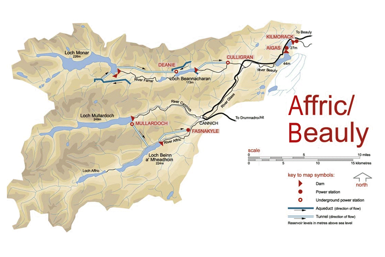
- There are six individual power stations; Mullardoch, Fasnakyle, Deanie, Culligran, Aigas and Kilmorack.
- There are seven dams; Mullardoch, Benevean, Monar, Loichel, Beannacharan, Aigas and Kilmorack.
This map from the SSE Renewables web site shows the layout of the dams and power stations.
This description of the scheme is from Wikipedia.
The Affric / Beauly hydro-electric power scheme for the generation of hydro-electric power is located in the western Highlands of Scotland. It is based around Glen Strathfarrar, Glen Cannich and Glen Affric, and Strathglass further downstream.
The scheme was developed by the North of Scotland Hydro-Electric Board, with plans being approved in 1947.
The largest dam of the scheme is at Loch Mullardoch, at the head of Glen Cannich. From there, a tunnel takes water to Loch Beinn a’ Mheadhoinn (Loch Benevean) in Glen Affric, via a small underground power station near Mullardoch dam. Loch Benevean is also dammed, with a tunnel taking water to the main power station of Fasnakyle, near Cannich.
To the north in Glen Strathfarrar, Loch Monar is dammed, and a 9 km tunnel carries water to an underground power station at Deanie. Further down the glen, the River Farrar is dammed just below Loch Beannacharan, with a tunnel to take water to Culligran power station (also underground).
The River Farrar joins with the River Glass near Struy to form the River Beauly. Downstream on the River Beauly, dams and power stations have been built in gorges at Aigas and Kilmorack.
As the rivers in this scheme are important for Atlantic salmon, flow in the rivers is kept above agreed levels. The dams at Kilmorack, Aigas and Beannacharn contain Borland fish lifts to allow salmon to pass.
Note
- Culligran, Deanie and Mullardoch power stations are underground.
- Loch Beannacharan is the English name for Loch Beinn a’ Mheadhoin.
- The salmon impose a constraint on water levels.
The sizes of the power stations in the scheme are as follows.
- Mullardoch – 2.4 MW
- Fasnakyle – 69 MW
- Deanie – 38 MW
- Culligran – 19 MW
- Aigas – 20 MW
- Kilmorack – 20 MW
This gives a total power of 168.4 MW.
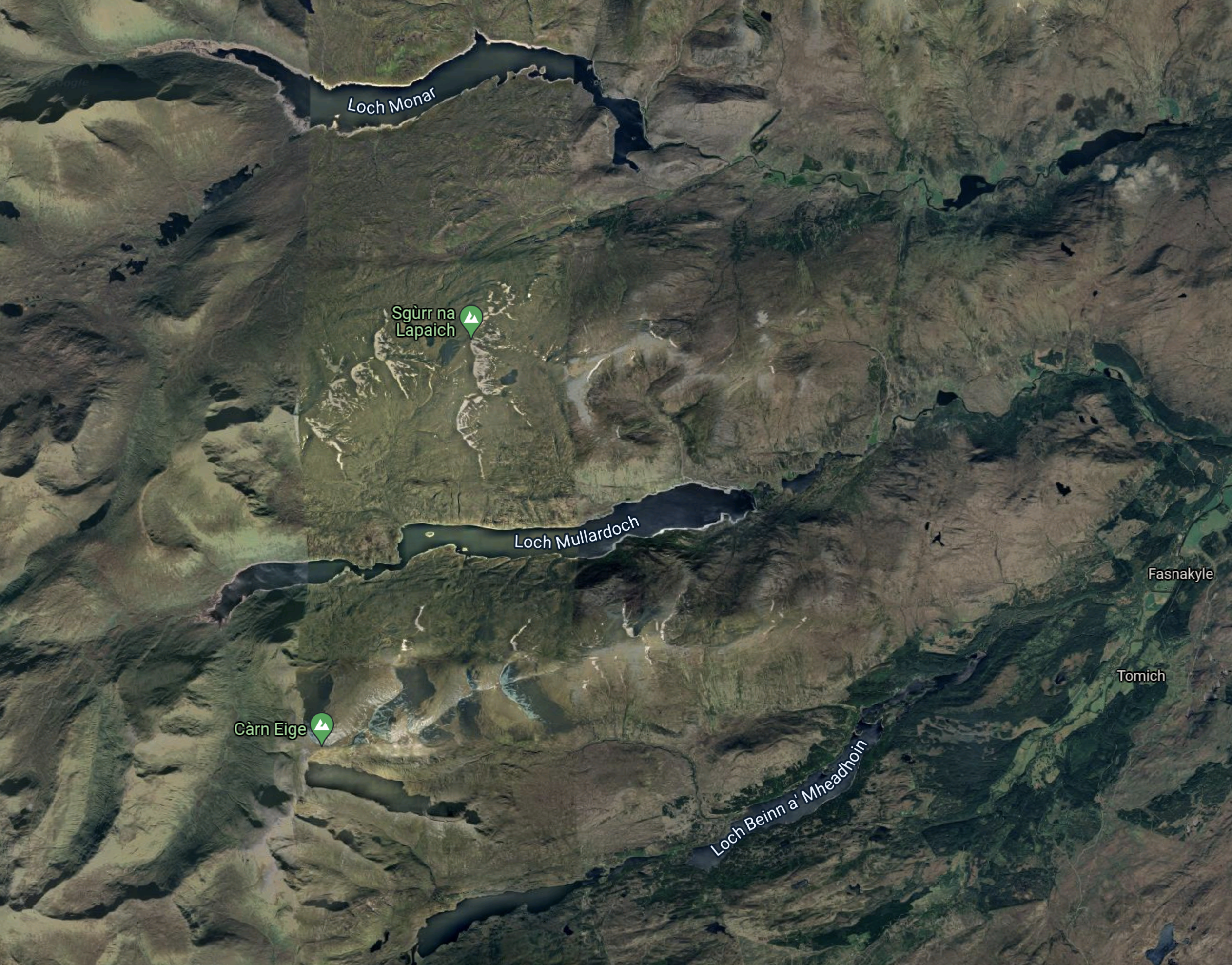
This Google Map shows the Western area of the SSE Renewables Map.
Note.
- The three lochs; Monar, Mullardoch and Beinn a’ Mheadhoin can be picked out on both maps.
- Fasnakyle, where the largest of the hydro-electric power stations in the Affric/Beauly scheme, is at the Eastern edge of the map about half-way up.
- The area doesn’t seem to have a large population.
This Google Map shows the location of Fasnakyle power station in more detail.
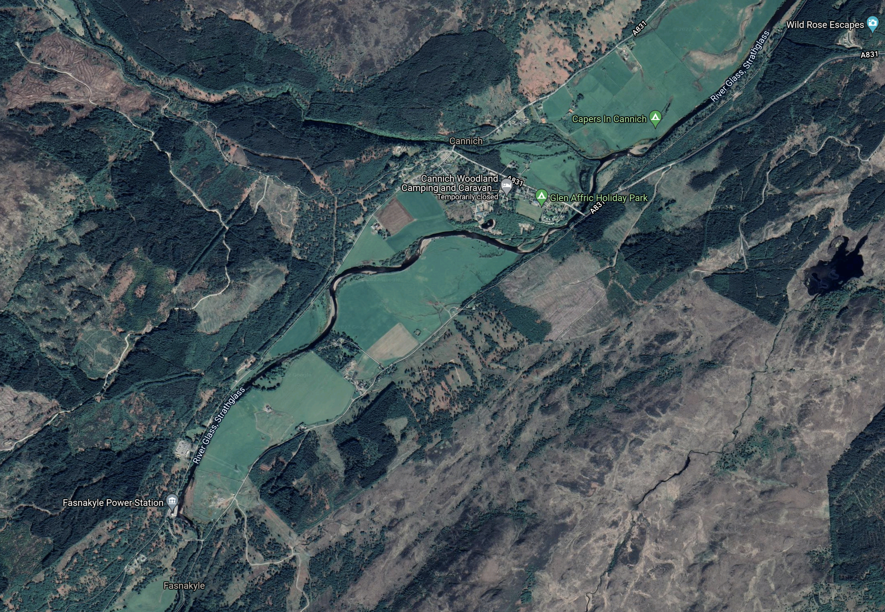
Note.
- Fasnakyle power station is in the South-West corner of the map. marked by a grey flag.
- It appears that all of the water that goes through the power station flows into the River Glass, Strathglass, which meanders its way towards Inverness on the bottom of what appears to be a broad valley.
This Google Map shows the next section of the river.
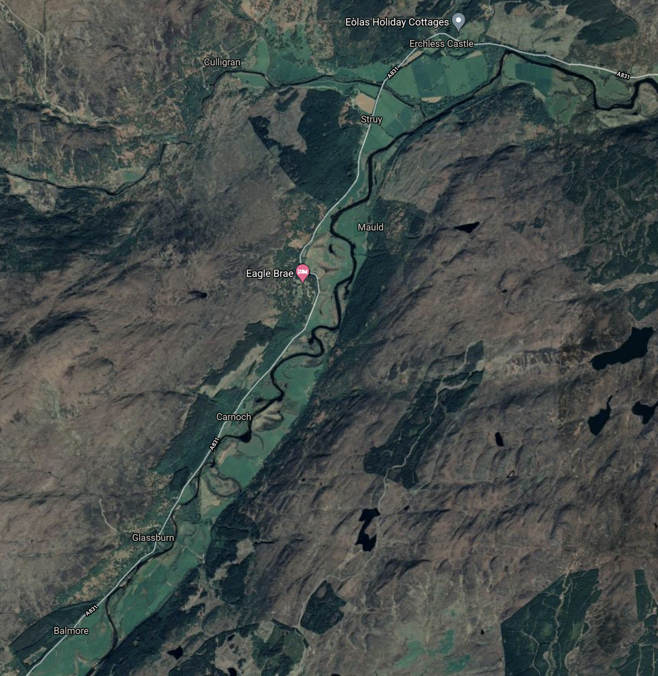
The River Glass, Strathglass joins the River Farrar near the top of the map an becomes the River Beauly.
This Google Map the River Beauly to Kilmorack.
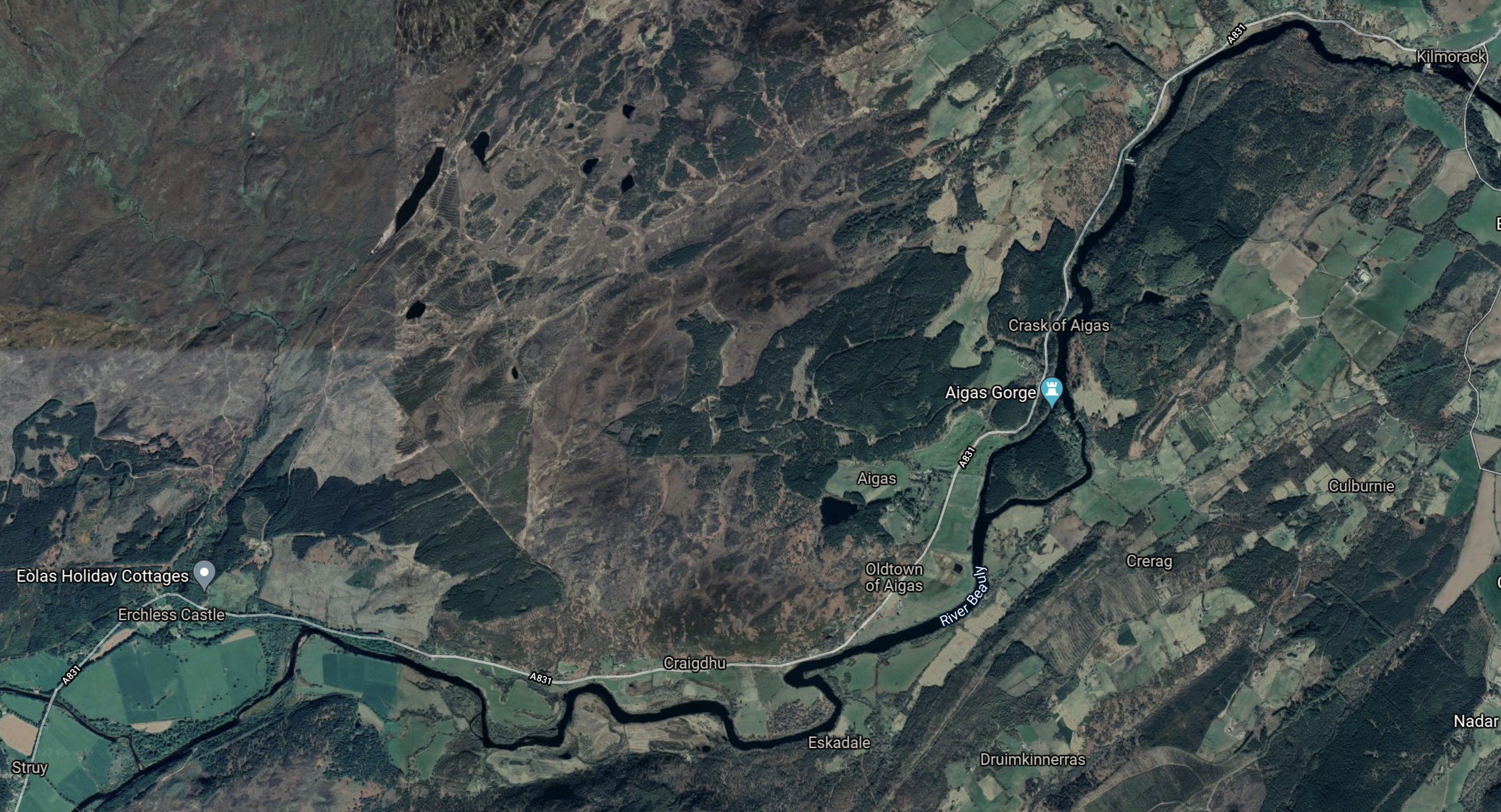
Wikipedia says this about this section of the River Beauly.
The river is part of the Affric-Beauly hydro-electric power scheme, with dams and power stations at Aigas and Kilmorack. Both have 20MW generators and include fish ladders to allow salmon to pass, the Aigas fish ladder is open to visitors in the summer.
This last Google Map shows the Beauly Firth.
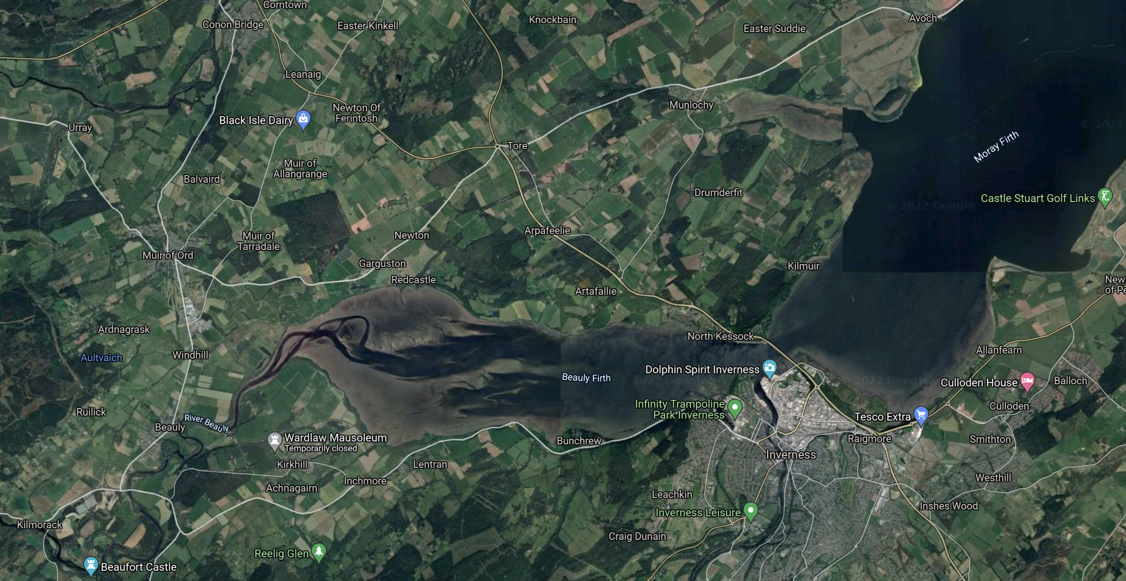
Note.
- Kilmorack is in the South-West corner of the map.
- The River Beauly flows into the Beauly Firth and ultimately out to see in the Moray Firth.
- The water flows past Inverness to the North.
It does strike me, that a lot of the water collected in the dams to the West of Fasnakyle, flows out to sea.
Strathclyde University And Pumped Storage Power For Scotland
This page on the Strathclyde University gives a list of the pumped storage potential for Scottish hydrogen-electric dams and power stations.
A figure is given for only one dam or power station in the Affric/Beauly scheme.
- Fasnakyle – 78 GWh
That would be a lot of pumped storage.
Water Flows In The Affric/Beauly Scheme
Looking at the SSE Renewables map of the Conon scheme, water flows appear to be as follows.
- Loch Monar to Loch Beannacharan via Deanie power station
- Loch Beannacharan to River Beauly via Culligran power station
- Lochs Mullardoch and Beinn a’ Mheadhoin both supply water to the Fasnakyle power station
- Fasnakyle power station to River Beauly via the River Glass, Strathglass.
- River Beauly to Beauly Firth via Aigas and Kilmorack power stations.
Note.
- Water from Loch Moray goes via Deanie , Culligran, Aigas and Kilmorack power stations on its journey to the sea.
- Water from Loch Mullardoch goes via Mullardoch , Fasnakyle, Aigas and Kilmorack power stations on its journey to the sea.
- Water from Loch Beinn a’ Mheadhoin goes via Fasnakyle, Aigas and Kilmorack power stations on its journey to the sea.
Fasnakyle, Aigas and Kilmorack power stations must work very hard.
Refurbishing And Repurposing The Affric/Beauly Scheme
Perhaps as the power stations are now over fifty years old, one simple way to increase the generating capacity of the Affric/Beauly scheme might be to selectively replace the turbines, with modern turbines, that can generate electricity more efficiently.
I suspect that SSE Renewables have an ongoing program of improvements and replacements for all of their hydro-electric stations in Scotland. Some turbines at Sloy power station have already been replaced with larger ones.
I also suspect that the whole scheme has a very sophisticated control system.
Consider.
- There is a need to control water levels to agreed minimum levels for the Atlantic salmon.
- Hydro-electric power stations have the ability to get to full power quickly, to cover sudden demands for more electricity.
- Electricity only needs to be generated if it can be used.
- Water might be held in Lochs Mullardoch and Beinn a’ Mheadhoin, as a reserve, as it goes through three or four power stations when it is released.
Over the years, SSE Renewables will have developed very sophisticated control philosophies.
Adding Pumped Storage To The Affric/Beauly Scheme
To do this a source of fresh-water must be pumped into Loch Mullardoch or Beinn a’ Mheadhoin, when there is a surplus of electricity.
It looks from Google Maps, that the river system between Fasnakyle and Aigas power stations has been effectively turned into a canal.
- I wonder, if it is deep enough to contain enough water to act as the lower level reservoir of a pumped-storage system.
- The higher level reservoir would be Loch Mullardoch.
- There would be a height difference of 200 metres.
- Calculations show around 1850 cubic metres of water would need to be pumped into Loch Mullardoch to store one MWh.
So long as enough water is left for the salmon, I suspect that if a way of pumping water from the River Glass to Loch Mullardoch, that an amount of pumped-storage can be added.
Conclusion
There would appear to be only one scheme, but if it was built it could add over 50 GWh of pumped storage.
Fracking Has a Bad Rep, but Its Tech Is Powering A Clean Energy Shift
The title of this post, is the same as that of this article on Texas Monthly.
It shows how former frackers are developing their techniques to do the following.
- Extract heat and energy from shale using water.
- Store energy safely underground.
- Drill deeper and better geothermal wells.
One of the companies; Quidnet has been backed by Bill Gates and his friends. I wrote about Quidnet Energy a couple of years ago in How Do You Save Clean Energy? This Company Plans To Pump It Underground.
And all in environmentally-friendly ways, that would get a seal-of-approval from a committed anti-fracker.
It’s the best article I’ve read this week.
A Possible Balmacaan Pumped Storage System
This article on Power Technology is entitled SSE Proposes Loch Ness Hydro Power Plant.
These are the first three paragraphs.
Scottish and Southern Energy (SSE) has begun consultations to develop a 600MW hydro electric power plant on the shores of Loch Ness in Scotland.
SSE proposes to build a pumped storage scheme on the Balmacaan Estate between Invermoriston and Drumnadrochit.
The plan also includes construction of a dam and a new reservoir at Loch nam Breac Dearga, north-east of Invermoriston, according to Inverness-courier.co.uk.
This Google Map shows the location of Loch nam Breac Darga.
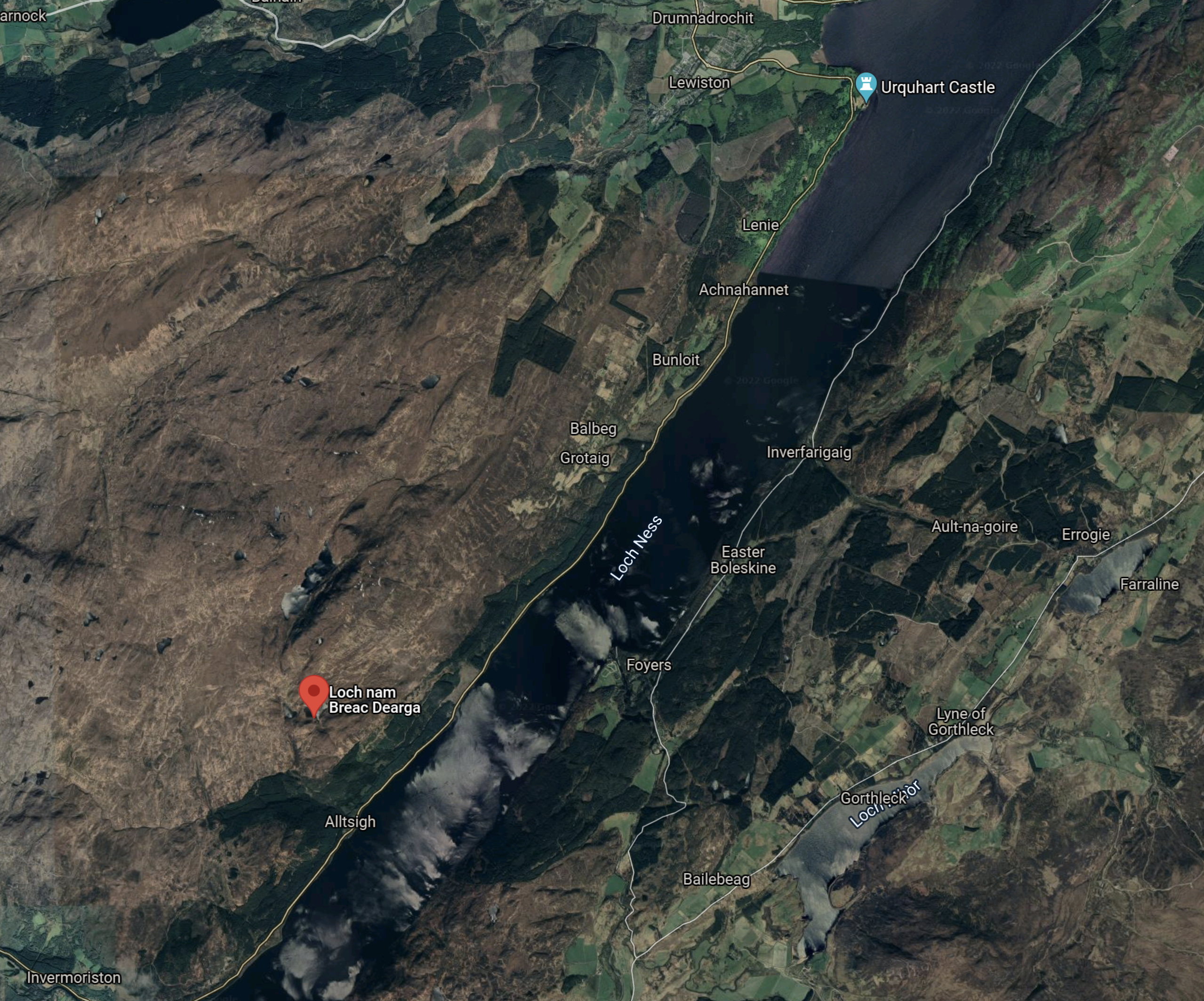
Note.
- Loch Ness runs diagonally across the map.
- Invermoriston is in the South-West corner of the map.
- Loch nam Breac Darga is marked by the red arrow and is 452 metres above sea level.
- Drumnadrochit is at the North of the map, just to the West of Urquhart Castle.
- The Foyers Pumped Hydro scheme, which I wrote about in The Development Of The Foyers Pumped Storage Scheme is on the opposite bank of Loch Ness from Loch nam Breac Darga.
This could be Scotland’s largest hydro-electric plant.
I can’t find a value for the amount of energy that can be stored, but I suspect it could be in the order of 15-20 GWh.
The stories about this project seem to be thin on the ground, so could it be that this project has been placed on the back burner by SSE.
Errochty Hydro-Electric Power Station
The Errochty hydro-electric power station is one of the stations in the Tummel hydro-electric power scheme.
This Google Map shows the relative locations of Lochs Errochty, Rannoch and Tummel.
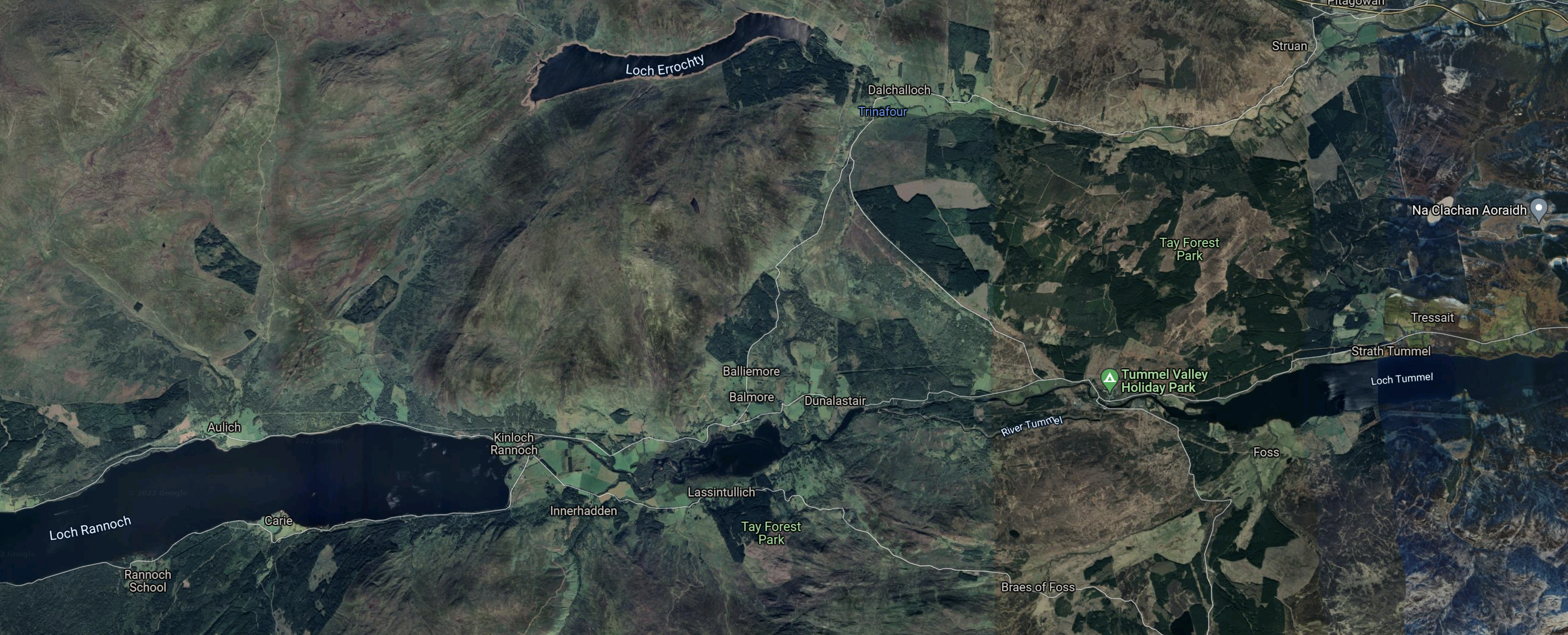
Note.
- Loch Errochty is at the top in the middle.
- Loch Rannoch is in the West.
- Loch Tummel is in the East.
This Google Map shows the Eastern end of Loch Errochty.
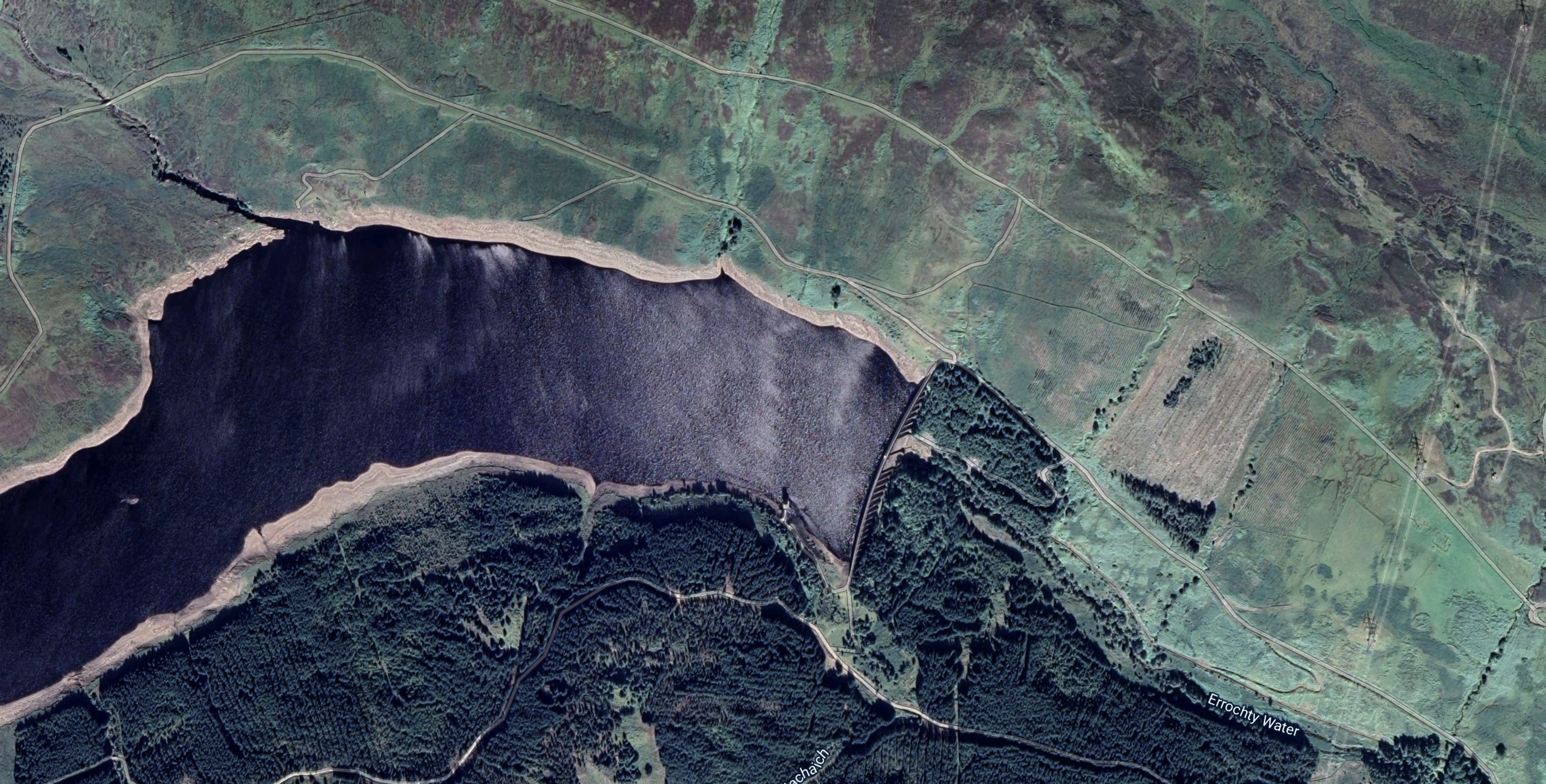
Note the dam at the Eastern end of the loch.
- The dam is 354 metres long by 49 metres high.
- The dam was built in 1957 and the lake is man-made.
- The loch stands at 330 metres above sea level.
- Water flows from the loch to the Errochty power station at the Western end of Loch Tummel, through a ten kilometre long tunnel.
This Google Map shows Errochty power station and Loch Tummel.
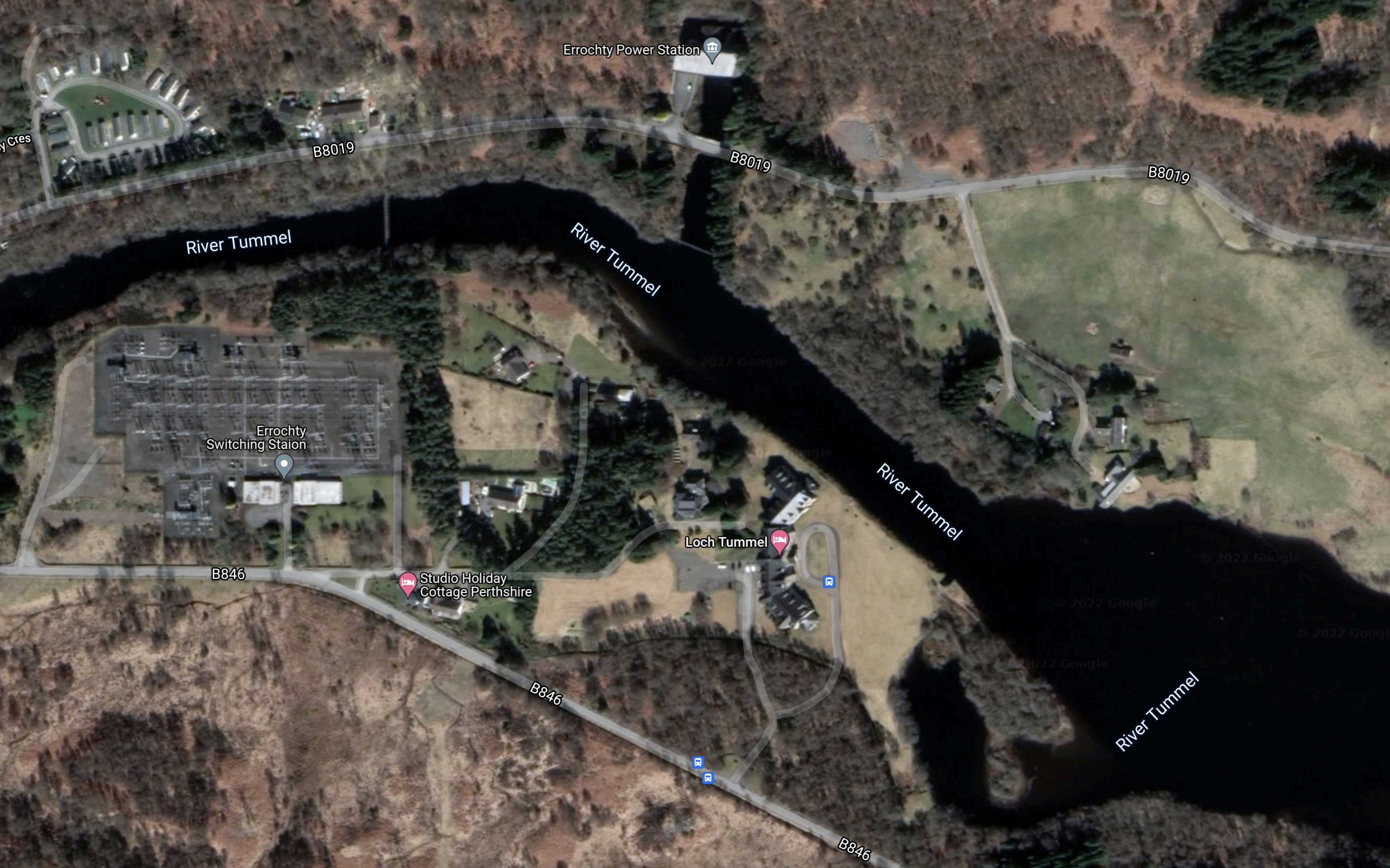
Note.
- Errochty power station is at the top of the map in the middle on the channel connecting it to the River Tummel.
- Errochty power station has two turbines and a maximum output of 75 MW.
- There is what appears to be a large switching station at the Western side of the map.
This page on the Strathclyde University gives a list the pumped storage potential for the Scottish hydrogen-electric power stations.
It states that the Errochty power station and Loch Errochty have a potential to be upgraded into a 16 GWh pumped storage scheme.
I obviously don’t know for sure, but I suspect this could be an easier scheme to convert, if the current turbines could be replaced with pump/turbines.
Water Supply To The Loch
There is a section with this title in the Wikipedia entry for Loch Errochty.
This is said.
Loch Errochty’s main feeder streams are the Allt Sléibh and the Allt Ruighe nan Saorach which both rise in the high ground to the west of the head of the loch. Other small streams flow directly off the 892-metre-high (2,927 ft) mountain of Beinn a’ Chuallaich which stands just to the south. Supplementary water is diverted into the loch from the east by the Errochty catchwater, a system of tunnels and surface pipelines at a height of approximately 380 metres which redirects water from five small tributary streams of the River Garry, and the Garry itself. The catchwater then goes through a tunnel in the hill which separates the Garry and Errochty valleys to join the loch. This method of re-directing water allows it to be used more often to generate electricity. Some of the water within the Tummel scheme passes through five of the power stations and thus generates electricity five times.
That strikes me as being very sophisticated for the 1950s and if the engineering and tunnels are up to a high standard, it might be that conversion of this power station to a 75 MW power station with 16 GWh pumped storage is a distinct possibility.
It might even be possible to increase the generating capacity of the power station.
Onshore And Offshore Wind Energy Capacity Predicted To Increase By 230% By 2030
The title of this post, is the same as that of this article on insider.
The report was commissioned by Scottish Renewables to assess the effects on the supply chain in Scotland.
But it does show that Scotland is on the way to be able to supply a lot of its electricity from wind farms, which would be backed up by some of another of pumped storage schemes under development.
Up To 24GW Of Long Duration Storage Needed For 2035 Net Zero Electricity System – Aurora
The title of this post, is the same as that of this article on Current News.
This the first three paragraphs.
Deploying large quantities of long duration electricity storage (LDES) could reduce system costs and reliance on gas, but greater policy support is needed to enable this, Aurora Energy Research has found.
In a new report, Aurora detailed how up to 24GW of LDES – defined as that with a duration of four hours or above – could be needed to effectively manage the intermittency of renewable generation in line with goals of operating a net zero electricity system by 2035. This is equivalent to eight times the current installed capacity.
Additionally, introducing large quantities of LDES in the UK could reduce system costs by £1.13 billion a year in 2035, cutting household bills by £26 – a hot topic with energy bills on the rise as a result of high wholesale power prices.
The report also says that long duration storage could cut carbon emissions by ten million tonnes of carbon dioxide per year.
I feel strongly, that this is a target we will achieve, given that there are at least four schemes under development or proposed in Scotland.
- Balliemeanoch – 45 GWh
- Coire Glas – 30 GWh
- Corrievarkie – 14.5 GWh
- Loch Sloy – 14 GWh
- Red John – 2.8 GWh
It certainly looks like the Scots will be OK, especially as there are other sites that could be developed according to SSE and Strathclyde University.
We probably need more interconnectors as I wrote about in New Electricity ‘Superhighways’ Needed To Cope With Surge In Wind Power.
There are also smaller long duration storage systems under development, that will help the situation in the generally flatter lands of England.
One of them; ReEnergise, even managed to sneak their advert into the article.

Their high density hydro could be a good way to store 100 MWh or so in the hills of England. As they could be designed to fit into and under the landscape, I doubt their schemes would cause the controversy of other schemes.
Conclusion
I think we’ll meet the energy storage target by a wide margin.
A Lower-Cost Pumped Hydro Storage System
Whilst writing some of the posts recently about pumped storage I came across the Loch Sloy Hydro-Electric Scheme.
This is the introductory sentence in Wikipedia.
The Sloy/Awe Hydro-Electric Scheme is a hydro-electric facility situated between Loch Sloy and Inveruglas on the west bank of Loch Lomond in Scotland.
This page on the Greenage web site gives comprehensive details of the power station and is well worth a read.
This Google Map shows the Lochs Sloy and Lomond.
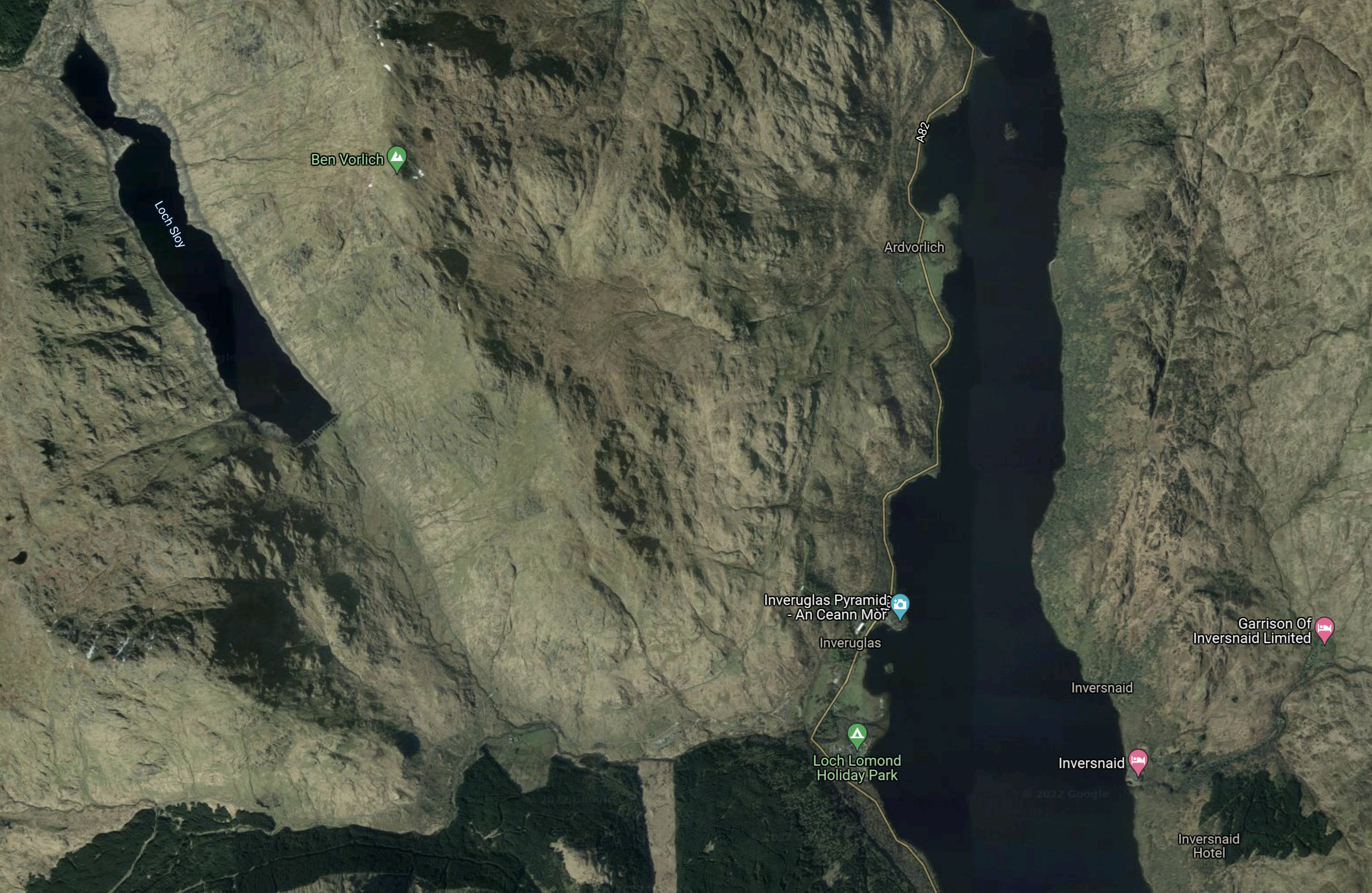
Note.
- Loch Sloy is in the North-West corner of the map.
- The page on Greenage says that Loch Sloy can store 14 GWh of electricity
- Loch Lomond is the body of water towards the Eastern side of the map.
- Inverglas is on the West bank of Loch Lomond to the North of the Loch Lomond Holiday Park, which is indicated by the green arrow with a tent.
This second Google Map shows the power station and Inverglas.
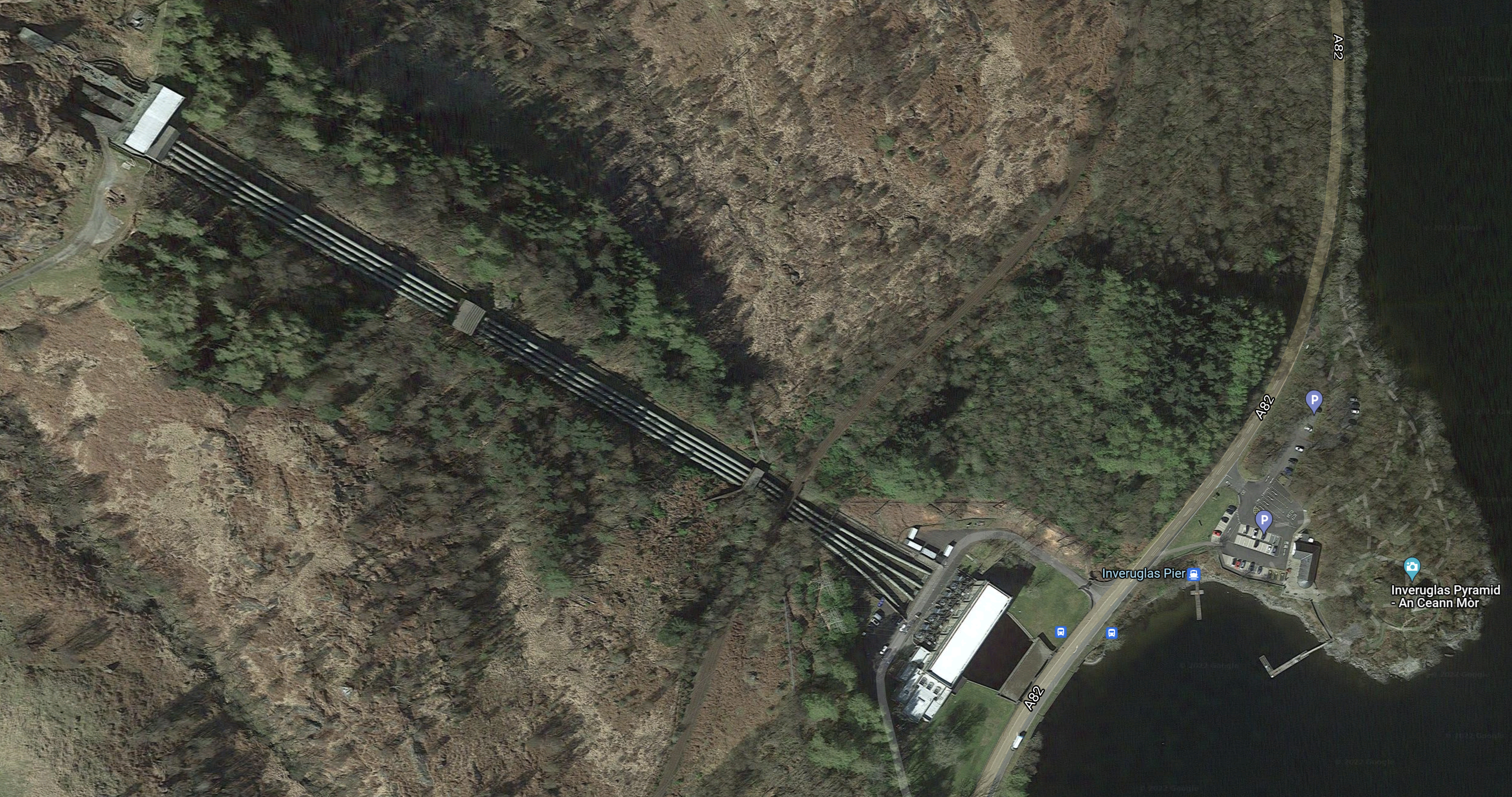
Note.
- It is a classic layout for a hydro-electric power station.
- In the North West corner of the map is the valve house, which is connected to Loch Sloy by a three kilometre tunnel.
- The valve house controls the water flows to the power station by Loch Lomond.
- There are four two-metre pipes running down the hill, one for each of the four turbines.
- According to the page on Greenage, the power station has three 40 MW turbines and one 32 MW turbine, which gives a total output of 152 MW.
- The water discharges into Loch Lomond after doing its work in the power station.
Loch Sloy is the largest conventional hydroelectric power plant in the UK.
Extending The Loch Sloy Hydro-Electric Scheme
This page on Hydro Review, which is dated the 10th of November 2010, is entitled SSE Gets Government Consent For Sloy Pumped-Storage Hydropower Project.
These are the first paragraph.
SSE Generation Ltd., the wholly owned generation business of Scottish and Southern Energy, has received consent from the Scottish Government to develop a 60-MW pumped-storage hydro project at its existing Sloy hydropower station at Loch Lomond, SSE reported.
Note.
- Two 30 MW pumps will be added to the power station to pump water up the hill from Loch Lomond to Loch Sloy.
- According to the page on Greenage, if the two pumps worked together for six hours, they would transfer 432,000 m3 of water. Note that a cubic metre of water weighs a tonne.
- Water would be transferred, when there was a surplus of energy being generated over the demand.
It would appear to be a simple scheme, as it is just adding two pumps to pump the water up the hill.
- As pumps rather than pump/turbines as at Foyers are used, there is no corresponding increase in generating capacity.
- Water also appears to be pumped up to the valve house in the existing pipes.
- Loch Sloy and Loch Lomond would not need major works to enable the scheme..
The page on Greenage gives the cost at just £40 million.
Originally, the project was supposed to have started in 2012, but as there are environmental problems with the fish, the work has not started.
These problems are detailed on the page on Greenage.
Conclusion
For £40 million, 14 GWh of pumped storage can be created at Sloy.
- But it could be bigger than 14 GWh, as this page on the Strathclyde University web site, says 20.4 GWh is possible.
- This would surely, be a project that could be first in the queue, once the environmental problems are solved.
20 GWh of pumped storage would be nice to have reasonably quickly.
ILI Group Announces New 1.5GW Pumped Storage Hydro Project
The title of this post is the same as that of this article on Insider.
This is the body of the article.
Intelligent Land Investments Group (ILI) has commenced the initial planning phase for its new 1.5 GigaWatt (GW) pumped storage hydro (PSH) project, Balliemeanoch, at Loch Awe in Argyll & Bute.
This is ILI’s third and largest PSH project. Its other PSH projects include ‘Red John’ at Loch Ness, which was awarded planning consent from Scottish Ministers in June Last year, and ‘Corrievarkie’ at Loch Ericht for which they aim to submit a Section 36 planning application in August.
The new project would be able to supply 1.5GW of power for up to 30 hours, enough to power 4.5 million homes.
The project will create a new head pond in the hills above Loch Awe capable of holding 58 million cubic metres of water when full and it is estimated the project will offset more than 200 million tonnes of CO2 emissions over its lifetime.
I would assume that this will be a privately-financed project and at 45 GWh it will be one of the largest pumped storage systems in the world.
But it must show that if it is privately-financed that the big boys in infrastructure finance, see pumped storage as a safe place to put insurance and pension funds to earn a worthwhile return.
- No-one’s going to steal one of these systems.
- They are a job-creating asset when built.
- Hydro-electric power seems very safe, when well-built.
- You don’t see media reports of schemes like Cruachan, Electric Mountain and Foyers breaking down.
In World’s Largest Wind Farm Attracts Huge Backing From Insurance Giant, I talked about Aviva’s funding for wind farms. If Aviva wukk fund those, surely they’ll fund schemes like this, as it could be argued that they make wind farms a better investment and more valuable, as they won’t have to shut down so often, when there’s too much power.
The Development Of The Foyers Pumped Storage Scheme
This leaflet from SSE Renewables probably gives as good a record as any others about the development of the Foyers Pumped Storage Scheme.
This is the introduction.
The Foyers Scheme is a 300 Megawatt (MW) combined conventional hydro and pumped storage scheme. 1896 saw the British Aluminium Company commission Foyers for the smelting of aluminium. The plant was in continuous operation for 70 years until it’s closure in 1967. The scheme was promoted by NOSHEB in February 1968 and after receiving statutory approval in April 1969 work started that autumn and was commissioned in 1975 . The high level reservoir is Loch Mhor which was formed under the original development by enlarging and joining Loch Garth and Loch Farraline.
The full catchment area of Loch Mhòr today is now 207 sq km.
Note that NOSHEB stands for North of Scotland Hydro Electric Board.
This Google Map shows Loch Mhòr.
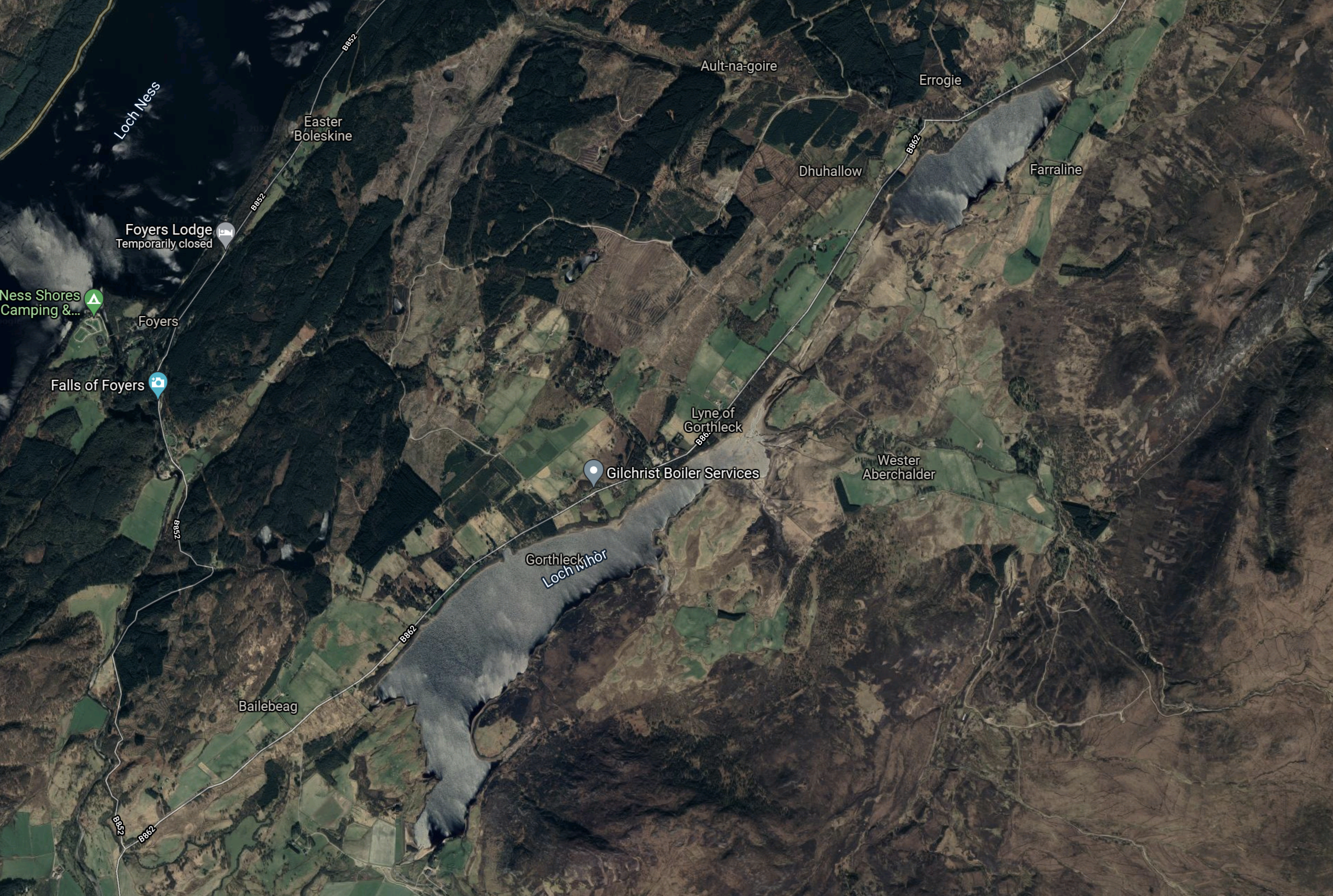
Note.
- Loch Ness is in the North West corner of the map.
- Loch Mhòr is the loch running diagonally across the map.
- Loch Mhòr was originally two separate lochs; Loch Garth in the South-West and Loch Farraline in the North-East.
- The power station is on the shores of Loch Ness.
I have found a document on the Internet, that says that the current storage capacity of Loch Mhòr is 10 GWh. That figure, if it is correct, would make the Foyers pumped storage scheme a small amount bigger than Electric Mountain.
The Original Scheme
The original scheme appears to have been a straight hydro-electric scheme with the water running from Loch Mhòr into Loch Ness through turbines. I don’t know how big it was and if anybody does, the figure needs to be inserted in this post. So if you know it, please tell me!
This gazetteer gives the figure at 3750 kW and also this history.
The British Aluminum Company development at Foyers was the first large-scale use of hydropower in Scotland. The scheme was highly influential, proving not only the viability of the technology to produce electricity with water driven turbines, but also that the power could be successfully applied to industrial processes. The British Aluminum Company went on to develop two large smelters in Scotland at Kinlochleven and Lochaber.
The original scheme generated electricity for seventy years.
The Current Scheme
There are effectively two parts of the current scheme, which was created in the early 1970s.
- The original 3.7 MW turbines have been replaced by a 5 MW turbine in the old power station.
- A new separate pumped storage power station has been built with two 150 MW pump/turbines.
This paragraph from the leaflet from SSE Renewables, gives brief details of the engineering.
When the station is generating, water flows from Loch Mhor through 2 miles of tunnels and shafts to the power station. When pumping, energy is drawn from the main transmission system at times of low load to drive the two 150 megawatt machines in the reverse direction and pump water from Loch Ness up to Loch Mhor. The existing gravity dam at the outlet of Loch Mhor (231.7m long and 9.14m high) was retained by NOSHEB . Remedial work was carried out on subsidiary earth embankment dams. The waters of the River Fechlin are diverted into Loch Mhor by a tunnel and the channel of the river.
From the complete description in the leaflet, it looks to be sound engineering.
Did Modern Project Management Enable This Scheme?
As someone, who was involved in writing project management software from about 1972, I do wonder if the arrival of ,odern project management around the mid-1960s was one of factors that prompted NOSHEB to carry out this scheme.
Other factors would have been.
- The original turbines were on their last legs after seventy years of generating electricity.
- There was a need for more pumped storage.
- This scheme was feasible.
I would very much like to meet one of the engineers and talk the scheme through.
Conclusion
This power station and its rebuilding as a pumped storage scheme has been carried out to an excellent standard and I wonder if similar techniques can be used to create new pumped storage systems around the world.
