New Fast Bus Service To Link London’s Outer Boroughs
The title of this post is the same as that of this article on the BBC.
This is the sub-heading.
A new fast service bus network has been announced for London’s outer boroughs.
These three paragraphs outline the concept.
Six new routes will be created and four incorporated into the ‘Superloop’ network, complete with distinct branding.
The plans propose a fast service to make more stops linking many of the peripheral boroughs.
The network is part of London Mayor Sadiq Khan’s effort to compensate for the impact of the ultra-low emission zone expansion, due to start in August.
This draft map from TfL illustrates the concept.
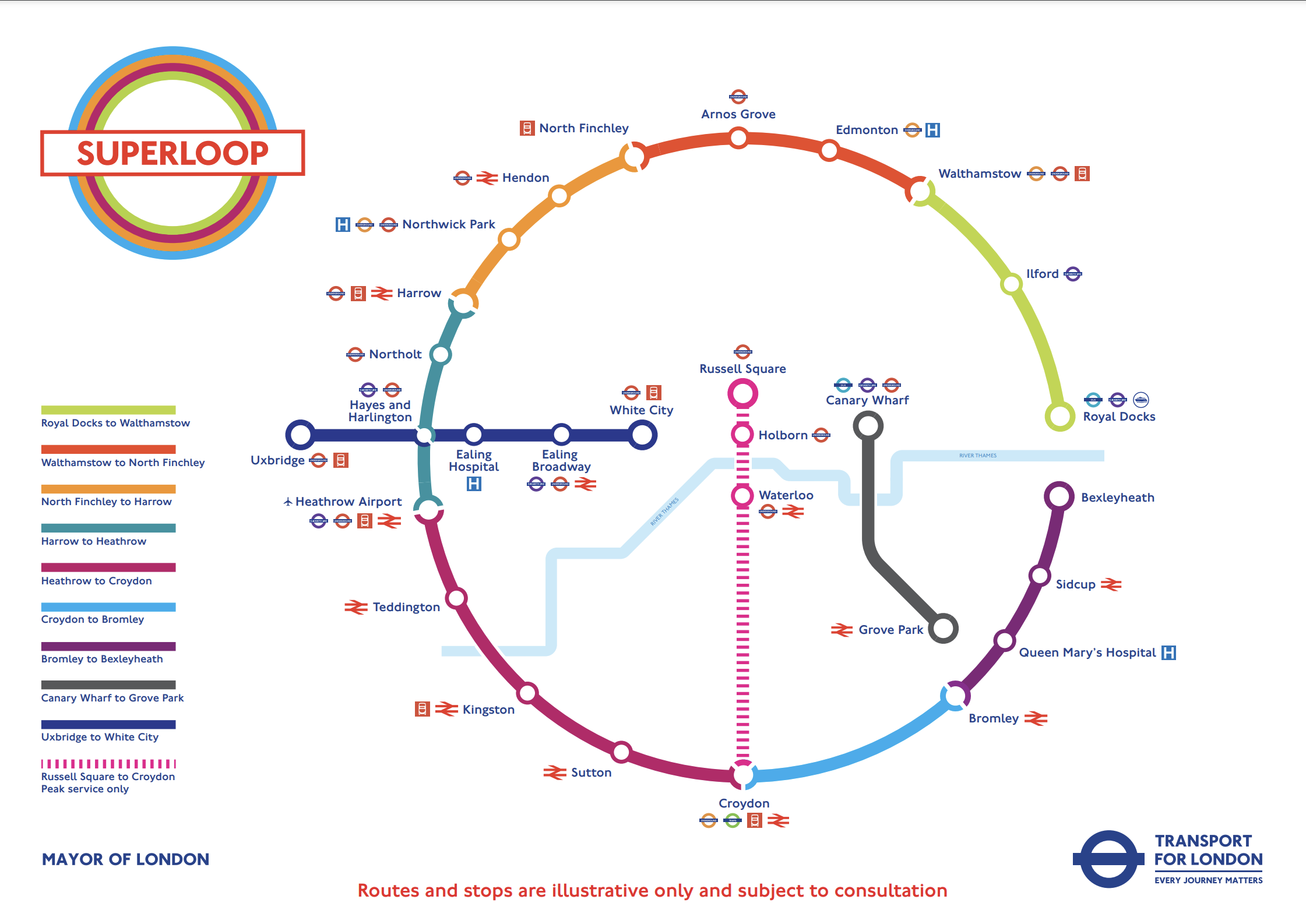
In the draft map, the following can be discerned.
- Arnos Grove station is in the North.
- West Croydon station is in the South.
- Royal Docks and Bexleyheath are in the East.
- Uxbridge and Hayes & Harlington stations are in the West.
- Elizabeth Line stations on the route include Ilford, Custom House, Heathrow Airport and Hayes & Harlington.
The plan may work well, as in the 1950s and 1960s, I used the 107 bus route very regularly, as it cut a circular path between Queensbury in the West and Enfield in the East.
I have some thoughts.
Royal Docks And Bexleyheath
This Google Map shows the Royal Docks.

Note.
- The dotted red line indicates the Royal Docks.
- The runway of the London City Airport can be seen.
- Custom House station on the Elizabeth Line is served by the Elizabeth Line and the Docklands Light Railway.
This second Google Map shows the Western end of the Royal Victoria Dock.

Note.
- Custom House station is in the North-East corner of the map.
- The Excel is on the East end of the map.
- London City Hall is at the Western end of the Royal Victoria Dock.
- The cable-car to Greenwich connects to the area.
I would suspect that the bus from Walthamstow will terminate close to City Hall and the cable-car.
This Google Map shows the Royal Docks and Bexleyheath.
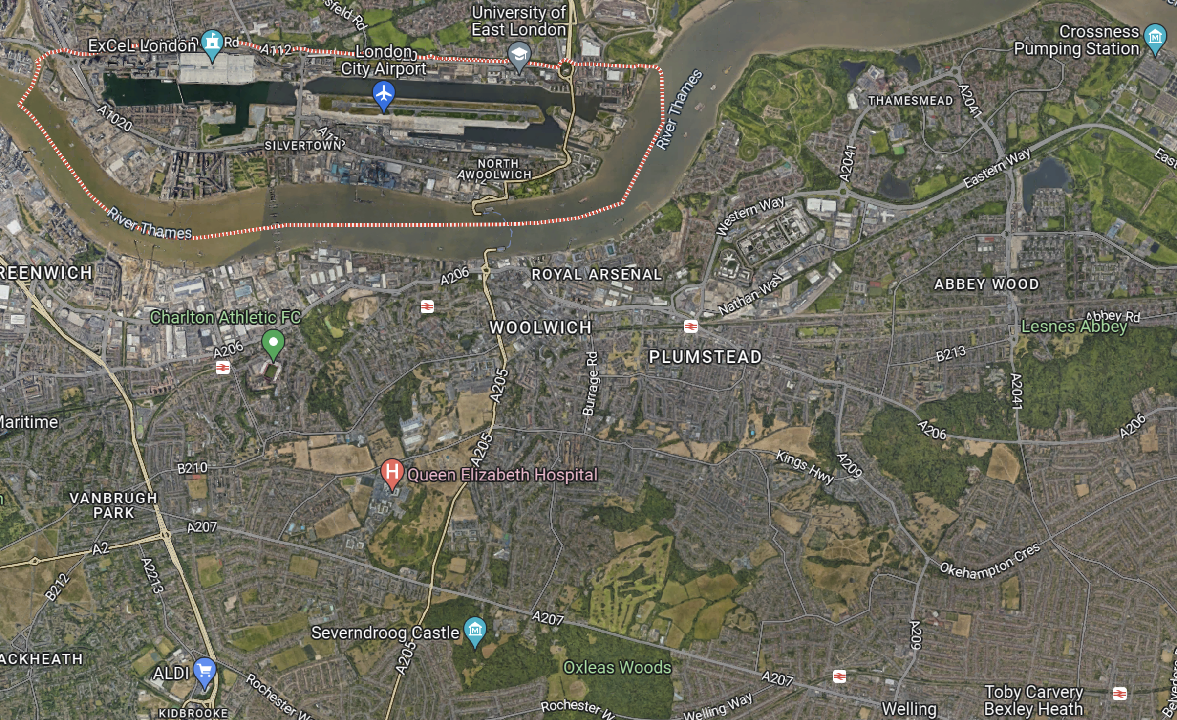
Note.
- The dotted red line indicates the Royal Docks.
- Bexleyheath station is in the South-East corner of the map.
I wouldn’t be surprised to see the Mayor organise a bus, through his new pet project; the Silvertown Tunnel.
Electric Or Hydrogen
Ideally, the buses will need to be zero-carbon; which means battery-electric or some form of hydrogen power.
Birmingham has a similar series of express routes, that run across the city, which I wrote about in Riding Birmingham’s New Hydrogen-Powered Buses.
I feel that long routes like some of these are should be run with hydrogen-powered buses, because of there longer range.

When you look at this Green line map you can see the origins of the orbital routes that are being re-marketted as Superloop

I well remember the 725 bus from Gravesend to Windsor, the cross capital 715 from Guildford to Hertford and the 712/713 from Dorking to Luton/Dunstable.
Comment by fammorris | March 28, 2023 |
It’s a good idea and I think parts of the outer bus circle may work well at certain times, but given London’s poor and distinctly non-radial road infrastructure and chronic traffic congestion, it’s very unlikely to work as well as it might have done in the 1950s. What we really need is London’s equivalent of the Paris Grand Express project, ie a new, fast, electrified railway network around the capital. Although some portions of existing rail routes do exist, it’s likely that it would need to be independent of as much of the existing rail network as possible, to avoid operational conflicts.
But no one in Britain has the vision for such a scheme, and no political party would commit to the serious investment needed.
Comment by Stephen Spark | March 28, 2023 |
Something must happen, as my journey on the X26, which I still have to write about was slow on congested roads.
The solutions proposed like air taxis won’t work, despite what their proposers say.
We’ve also got a housing stock of which much is not fit for purpose.
Comment by AnonW | March 28, 2023 |