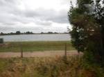
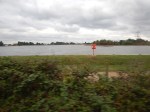
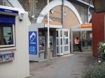
Between South Tottenham And Crouch Hill Stations
The stretch of the Gospel Oak to Barking Line between South Tottenham and Crouch Hill stations is almost rural, as the pictures show.


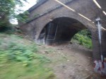


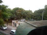
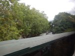

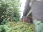
Note the pictures where the line passes over the junction of Seven Sisters and St. Ann’s Road, which was the site of the former St. Ann’s Road station. This Google Map shows most of the route of the line.
The GOBlin In North London
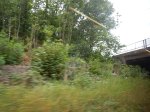
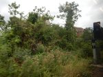
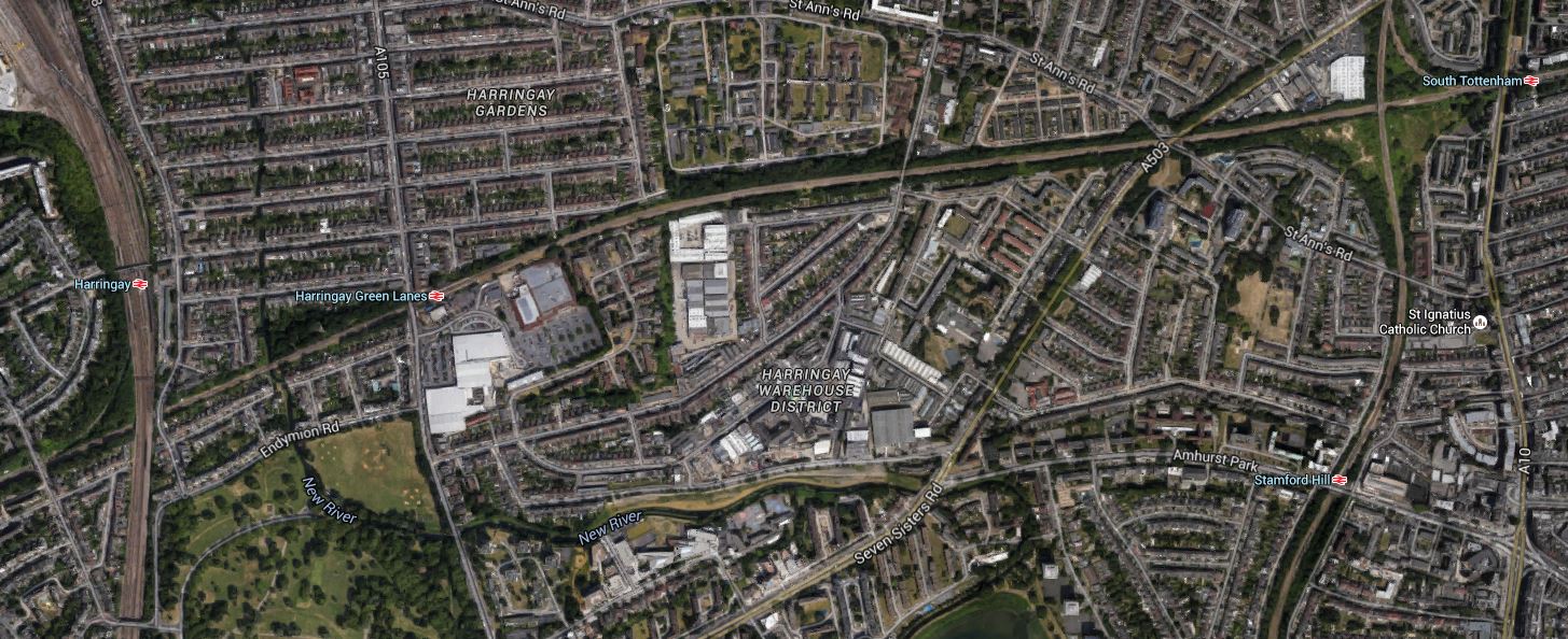
The area between St.Ann’s Road and South Tottenham stations, has been mentioned for a possible Seven Sisters station on the GOBlin, in Transport for London’s Plan for 2050.
The only things there at present is a lot of overgrown land and a Wickes store. It must be ripe for development as much-needed housing with a station on the GOBlin and a walking connection to the current Seven Sisters station for the Lea Valley Lines, the Victoria Line and in the future Crossrail 2.
Properly developers could make a lot of money here and the only complainers will probably be the low life who use the scrubland for nefarious purposes.
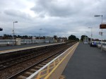
Before GOBlin Electrification – Crouch Hill
I’d never been to Crouch Hill station before, but I went to take these pictures.


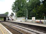


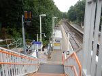

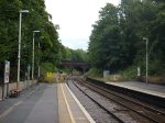


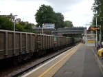
It is another tidy station with fairly long platforms, steep staircases and no lifts. Although unlike Leyton Midland Road, the station is in a cutting, rather than on a viaduct.
My pictures were as you can see interrupted by a dreaded Class 66 locomotive, with all its noise and smell passing through. After electrification, hopefully we’ll see something more environmentally-friendly like an elderly Class 90 or a brand new Class 88 locomotive. Unfortunately, I think we’ll see mainly Class 66s pulling freight trains for some years, as there are so many of them and they seem to be pretty reliable, although unloved by the drivers.
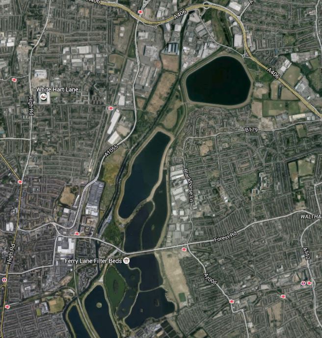
Across The North Of The Walthamstow Reservoirs
Between Blackhorse Road and South Tottenham stations, the Gospel Oak to Barking Line (GOBlin) passes between the large reservoirs of the Lea Valley that provide East London with most of its water.

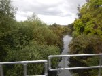

This area to the south of the GOBlin is being developed into the Walthamstow Wetlands. Incidentally, I was once on one of these trains and there was a grandfather (?) with serious binoculars showing a boy of about ten, the various water birds that were visible. Today, all I could identify was a few swans.
Because of the layout of the line, I wouldn’t bet against there being a station called Walthamstow Wetlands or River Lea at the western end of this journey, just before it crosses the West Anglia Main Line.
Is there a Bird or Nature Reserve in the UK with its own rail station?
Before GOBlin Electrification – Leyton Midland Road
Leyton Midland Road station is a tidy station, but it has steep stairs and no lifts.


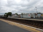
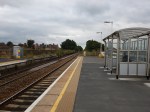
As the pictures show, the platforms are probably long enough for the new four-car trains.
Could The Gospel Oak to Barking Line Transform East London?
Two reports on the web prompted me to write this post.
The first was an article on CityMetric entitled Forget Road Bridges. TfL Should Extend The Overground To Thamesmead And Abbey Wood, which prompted me to write No To Silvertown Tunnel.
The second report was on various web sites with headlines like Enfield Council Shortlists Developers For Meridian Water.
Enfield Council is planning to build substantial numbers of new homes at a 85 ha site called Meridian Water near Lee Valley Regional Park over the next couple of dcades.
To help the development at Meridian Water, the station at Angel Road is to be improved and this page on the Meridian Water web site gives details. This extract details the development of the station and the related rail line and transport interchange.
The station will be a thriving new hub that combines rail and bus services to provide better access to Meridian Water for future residents and businesses. Meridian Water is a new £1.5 billion, 85 hectare, eco-development which will provide up to 5,000 new homes and up to 3,000 new jobs. The improvements, which will be completed in the next five years, will bring benefits for those that currently live and work in the area, as well as the new residents of the Meridian Water development. The project is being funded with £2.5 million from the Greater London Authority with a further £1 million from Enfield Council. This new station combined with additional investment in three tracking the railway, will bring forth a four trains per hour service at Angel Road Station.
All good stuff and very much about motherhood and apple pie in the manner of the way that the Metropolitan Railway used to sell Metroland.
But let’s not knock it for that, as London needs lots of new housing and the current station, Angel Road, which will be renamed Meridian Water, is one of the worst transport interchanges in the UK,. They’ve probably got better stations in many of the worst slums in The Third World.
Angel Road is just two platforms and a bridge as Before Crossrail 2 – Angel Road shows, whereas the average station in deepest Africa or South America, probably has at least someone, who’ll help you or sell you a tasty local morsel or a bottle of fizzy drink.
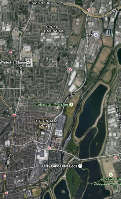
Whilst looking at developments in this area, it is worth looking at the wider area and investigate how transport links might develop. This Google Map shows the Lower Lea Valley from Angel Road and Meridian Water in the North to Lea Bridge Road in the South.
Lower Lea Valley
In addition to the housing developments at Meridian Water, more housing is being developed around Tottenham Hale station and other places in the area. But the development that will have the biggest impact on the area is not these developments but Thames Water and Waltham Forest’s massive plan to create the Walthamstow Wetlands. The project web site has this strap-line.
Transforming Walthamstow Reservoirs into a new urban wetland reserve for London
I have written about the Walthamstow Wetlands before in Before Crossrail 2 – Walthamstow Wetlands and now the project has its own web-site, I shall be following this exciting project a lot more. I believe the project has a lot going for it, but also it could be very important for Thames Water, who over the last few years haven’t exactly had the best of publicity at all times, what with our water bills and the Thames Tideway Scheme.
Because so much of London’s water is stored in the Lea Valley, it is very much in their interest to be good neighbours to the people and wildlife of the area.
The map also shows the rail links through the area.
1. The Lea Valley Lines
The Lea Valley Lines go northwards from Liverpool Street, Stratford and Hackney going up to Broxbourne, Hertford, Cambridge and Stansted Airport and as indicated earlier, extra tracks are being added and stations like Angel Road are being upgraded. A new station at Lea Bridge is also being built.
2. The Victoria Line
The Victoria Line goes underneath the area and links Central London to Tottenham Hale and Walthamstow. The line was built on the cheap in the 1960s and I have dreamed of what might have been. This August the line is closed to rectify one of its shortcomings, which will increase the capacity of the line.
3. The Chingford Branch Line
The Chingford Branch line crosses the Lea Valley Lines and the Walthamstow Wetlands as it links Chingford to Hackney and Liverpool Street. It is a line that can’t be extended, but there are plans to link it to the Lea Valley Lines by reinstating the Hall Farm Curve to allow trains to run from Stratford and Lea Bridge to Walthamstow and Chingford.
4. The Gospel Oak to Barking Line
The Gospel Oak to Barking Line (GOBlin) is the forgotten and down-trodden Cinderella, who could gatecrash the party in the Lea Valley and be a star of East London’s transport system.
Over the next few years, the following will or may happen to the line.
- Electrification
- Extension to Barking Riverside
- New four-car electric trains
- Smaller numbers of day-time freight trains.
- Increased passenger train frequency
The first three are hopefully cast in stone, as to cancel them now, would probably cost more than doing them. Especially, as the new trains have been ordered.
I am hopeful, that once the line is upgraded and electrified, this will enable freight operators to switch to electric traction, that could mean quieter services that might possibly run through at night.
As an aside, if I was standing for London Mayor, I would say I would put a limit of perhaps two non-electric trains a day on both the GOBlin and the North London Line. The freight operators would protest, but Class 66 locomotives have no business going through residential areas and crowded stations. Especially, when environmentally acceptable locomotives are available.
If the number of day-time freight trains could be reduced, this would allow more passenger services.
5. Crossrail 2
Crossrail 2 will have a big impact, when and if it arrives, as it will serve Tottenham Hale, Northumberland Park and Angel Road.
Before I finish this post, I have to ask, if we are doing enough with our transport network to serve large developments like Meridian Water, the Walthamstow Wetlands and Barking Riverside.
So what would I look at?
1. Crossrail 2
Politicians of all colours and tendencies are putting their faith in Crossrail 2.
But, I believe that the line, although surveys show it is much-needed, is a bit like the US Cavalry in a 1950s film, arriving in force after the poor settlers or ranchers have virtually been wiped out by the Indians.
We should prepare for Crossrail 2, so that all the engineering and architectural connections are there and all surface stations are upgraded over the next few years. This would mean that building Crossrail 2 would be just a matter of accurately threading the needles and then linking the tunnels to the existing stations.
Perhaps we should think of Crossrail 2 as a series of closely-related projects, rather than one huge mega-project.
- The main tunnels from Walthamstow Marshes to Wimbledon.
- The rebuilding of Central London stations to make them Crossrail 2-ready. Tottenham Court Road is already awaiting the tunnellers.
- The upgrading and rebuilding of the surface stations and rail infrastructure.
The great advantage of this, is that political responsibility for a lot of the work like the upgrading of surface stations, can be shared with the relevant Local Authority.
This post started with Enfield Borough Council and the Meridian Waters project and wandered into rail infrastructure, because Angel Road station is an important part of that project.
I doubt I’ll ever live long enough to see the opening of Crossrail 2. But I live in hope!
2. Improving Connectivity On The Gospel Oak to Barking Line
The Gospel Oak to Barking Line hasn’t got the best connectivity to other lines and it is also blessed with some difficult out of station interchanges for even strong walkers.
Walthamstow is an example, where the walk between Queen’s Road and Central isn’t that long but it is tortuous. This Google Map shows the area.
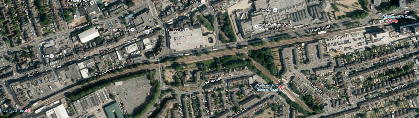
Walthamstow Stations
The East-West line is the Chingford Branch, with St. James Street station in the West and Central in the East. Croosing this line is the GOBlin with its station at Queen’s Road.
Surely something better could be done in Walthamstow. Interchange for someone pushing themselves in a wheelchair would be very difficult.
There is also an out of station interchange between Wansted Park on the GOBlin and Forest Gate on the lines out of Liverpool Street, which in a few years time will be Crossrail. This map shows the area.

Wanstead Park And Forest Gate
It is an area, where some selected development could be of value, especially as the GOBlin passes over the Liverpool Street Lines. I’ve walked this interchange a couple of times and the following would help.
- Step-free access at both stations. Forest Gate is getting this with Crossrail.
- A light-controlled crossing at Wansted Park station
- A minor rerouting of the buses so that some passing through the area stop at both stations.
This would mean that someone pushing themselves in a wheelchair could use the interchange.
One station that needs to be improved is Blackhorse Road, which connects the GOBlin to directly to the Victoria Line. This Google Map shows the area.
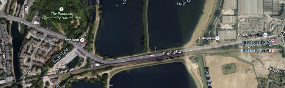
Blackhorse Road Stations
Note that the station site is not particularly cramped and it would be a not-to-difficult walk to the Walthamstow Wetlands, especially if you could hop on a bus for a couple of stops.
There is also the possibility of an improved station at Harringay Green Lanes, where a large amount of property development is possible according to this document on the Harringey Council web site. I talked about the possibilities in The Piccadilly And Victoria Lines, Manor House Station And Harringay Green Lanes Station, where I believe a flagship station could be built across Green Lanes.
This section in the Wikipedia entry for the GOBlin, lists other ideas for extra connectivity for the line.
But I believe there are three other important interchanges that will or may happen and I describe them in the next three sections.
3. Seven Sisters Interchange With Gospel Oak to Barking Line
Transport for London’s Plan for 2050, has a section in an Appendix with the heading of News links and/or Stations for Strategic Interchange. In a list of places where this might be done are the words Seven Sisters (GOB). Seven Sisters station is currently a valid out of station interchange with South Tottenham station on the Gospel Oak to Barking Line. In Crossrail 2 At South Tottenham/Sevens Sisters, I speculated as to how the two stations could be linked by a large double-ended Crossrail 2 station. This Google Map shows the two stations.
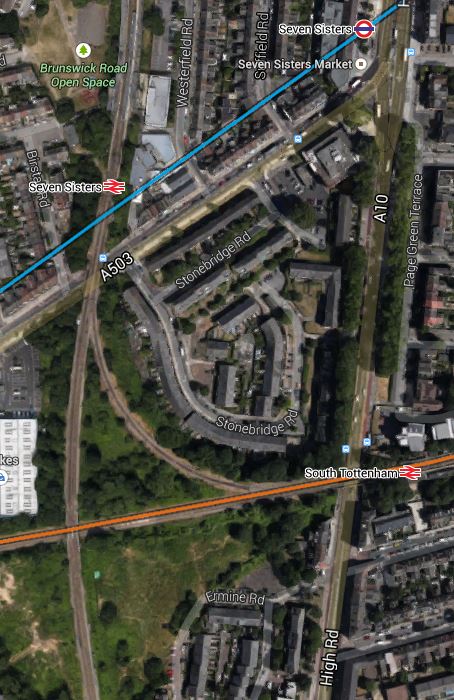
South Tottenham And Seven Sisters
There are also other possibilities here, like building a new station, housing or commercial development or allowing trains to link from the Northbound Lea Valley Lines through Seven Sisters to the Eastbound GOBlin. But whatever happens here, the GOBlin will eventually be linked to the Victoria Line and Crossrail 2.
Search the Internet and You’ll find little about this project, which is just two words buried in a TfL report.
4. Extending The GOBlin To Angel Road
This is speculation on my part, but the Meridian Water development will need more than just the one station at Angel Road. As the GOBlin goes across the southern part of the development site, is there an opportunity for an innovative connection through the development to Angel Road? This is a Google Map of the area from Angel Road in the North to Blackhorse Road in the East.
Blackhorse Road To Angel Road
The connection might be difficult for a train, but use a Class 399 tram-train and it could twist and turn its way between Blackhorse Road and Angel Road stations amongst the reservoirs and the developments to serve both those developments and the Walthamstow Wetlands.
5. Extending The GOBlin To Thamesmead And Abbey Wood
In No To Silvertown Tunnel, I examined the possibilities of extending the GOBlin from Barking Riverside over or under the Thames to Thamesmead and Abbey Wood station, where it would join up with Crossrail.
I felt that this would best be done using Class 299 tram-trains as they could go walk-about on both sides of the river giving much needed connectivity to the housing on both sides of the river. If it could be done, I felt that a bridge shared with pedestrians and cyclists would be the best way to join the two banks of the Thames.
6. The Hall Farm Curve, High Meads Loop and Dalston Eastern Curve
These three curves, if reinstated for passenger trains would create routes between the Chingford Branch and Lea Bridge, Stratford and any desirable station to the West. Reopening the Dalston Eastern Curve would give access to the East London Line for Crossrail at Whitechapel and South of the Thames.
As there could be spare capacity on the East London Line, which has been designed for twenty-four trains per hour, there could be a myriad of ways it can be used to increase the services under the Thames, so what Transport for London might do would be pure speculation on my part.
But I think they will eventually use these three curves to improve services in the Lea Valley.
7. Tram-Trains On The GOBlin
This may seem a bizarre idea, but having seen these hybrid vehicles all over Germany, I believe tram-trains are the way to add extra destinations to core electrified lines. On the Gospel Oak to Barking Line, in addition to being used to connect to Angel Road, as I showed previously, they could also be used with a tunnel or a bridge to extend the line from Barking Riverside under or over the river to Thamesmead and Abbey Wood.
People might worry that when running as trains, they may need different stations to the other trains, but the Germans seem to be able to design stations that accept both vehicles and I suspect the planned Rotherham extension of the Sheffield Supertram, will come up with solutions applicable to our standards. As to the required overhead lines, the Class 399 tram-trains can run using any of the voltages used for trams and trains in the UK.
There may be other places on the GOBlin and the other rail lines in East London, where tram-trains could be used effectively.
This will obviously be up to the planners, but I will be very surprised if tram-trains don’t infiltrate there way into many places all over the UK. At the moment transport planners, haven’t the experience of seeing a well-designed tram-train system working in the UK, but after what I believe will be a successful trial in Rotherham, I think we’ll see planners embracing the technology with open arms.
Conclusion
The GOBlin won’t be Cinderella any more!
Two Solutions To Make Crossing A Railway Safe
On the way to football tonight in Ipswich, I went to have a drink with a friend, who lives near Thurston station on the Ipswich to Ely Line, where there is a good real ale and cyder pub. Crossing the tracks at Thurston is via a simple walk across controlled by traffic lights between the two platforms.


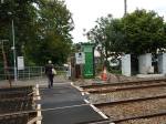
Of all the stations I use regularly, this is the only place where such a system is in use. Unless of course you count the trams at Ampere Road by the Croydon Ikea. A few hundred metres to the west of the station a bridle way and cycle path crosses the railway and Network Rail have built this bridge.


There have been reports like this one in the East Anglian Daily Times, which has a headline of Poll: £1.5m ‘monster’ railway bridge at Thurston is dubbed a ‘total waste of money’
This bridge is an interesting case of what to do where there are gated crossings of railway lines.
I think before being too critical of Network Rail we should bare these points in mind.
1. Suicide
This article on the BBC web site talks of a death at a crossing in the Thurston area. Network Rail get far too many deaths on the railway and it is a sad fact, that stepping in front of a train, is a common method of suicide.
2. The East-West Rail Link
The East-West Rail Link will use this line to get from Ipswich and Felixstowe to Cambridge and Ely. This link will be an electrified 100 mph railway that will run trains between East Anglia and the Midlands and the West. So although the line carries perhaps a couple of trains every hour each way, in perhaps ten years time, this will probably be a few times more. And as the line is pretty straight as the pictures show, the operating speed could be a lot higher.
3, Horses
If you read all the comments about the bridge no-one mentions taking a horse over the railway.
Horses are flight animals and if spooked will run fast away from the perceived danger.
Many horses too, don’t like going under high-voltage cables. Whether it is because they can sense the magnetic field generated by the electricity or they don’t like the whistling sound,I don’t know. But if the crossing is going to be used by horses, it will have to be of the size it has been built.
I’m not sure, but I think this is the only way to get a horse from one side of the railway to the other, unless you go all the way and go under the bridge by Thurston station.
4. Getting The Design Right
This bridge illustrates that getting the design right and satisfying all users and critics who never use the bridge is an almost impossible task.
Aesthetically, I don’t like the bridge, but unless they dig a subway under the railway, there is nothing else that can be done to satisfy all users and critics of the design.
Note that when the railway is upgraded to be part of the East-West Rail Link, Thurston station will have to be rebuilt and I suspect it will have a bridge over the railway, probably with lifts and a price tag well upwards of £2million.
There will be some serious discussions.
Crossrail Works In Front Of Liverpool Street Station
The archaeologists at Liverpool Street station have departed and work is getting on with the Crossrail works.


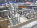
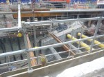
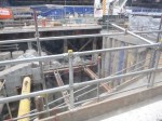
I’m glad to see that Crossrail have left the observation gallery.
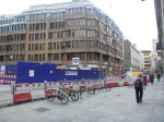
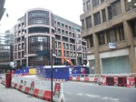
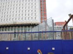
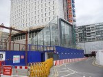
The Southern Entrance To Tottenham Court Road Station Takes Shape
One of the consequences of the building of Crossrail has been the need to virtually completely rebuild Tottenham Court Road station. The rebuild is not small as the station is future-proofed for the building of Crossrail 2, which will also call at the station. Wikipedia says this about future developments at the station.
If the proposed Chelsea-Hackney line, now known as Crossrail 2 when built, it will have a station at Tottenham Court Road, and the development plans include facilities to take account of this. This would be the only planned interchange between Crossrail 1 and Crossrail 2. A massive boost in capacity to the existing station will be needed to host both lines. The station was safeguarded as part of the route in 1991 and 2007. Redevelopment of the station will include space for platforms on the line.
The station is being rebuilt with a large ticket hall under the forecourt of Centre Point, which has a new northern exit on the corner of Oxford Street and Tottenham Court Road. These pictures show the new southern exit for the station taking shape.


It certainly looks like it will be dramatic. This page on the Stanton Williams web site has a picture of new entrances in front of Centre Point.
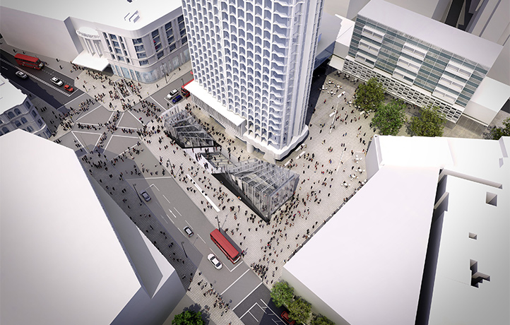
It certainly isn’t ordinary! It also looks like London is getting a new plaza.
I think the entrances open later this year, together with the reopening of the Central Line platforms. I took some of the pictures from the top deck of a 38 bus, which gives good views into the site as you go towards Islington from Piccadilly Circus.
It does look that the grubby end of Oxford Street is getting a major improvement.
Working Around The Victoria Line Closure
Today, I wanted to go to IKEA and a decent B & Q, so as both are close to Tottenham Hale station, it required a trip to that station or thereabouts.
The problem is that the Victoria Line is closed past Seven Sisters in August, so they can remove the bottleneck at Walthamstow Central that was part of the cheapskate design of the 1960s. Click here for the full story.
So I couldn’t take my usual route of an Undrground train to Tottenham Hale and a 192 bus.
I decided to go to IKEA first, which is just an easy trip all the way on a 341 bus from perhaps a hundred metres from my house. But as I got to the stop, the 341 whizzed past. Luckily it was followed by a 476 bus, which joins up with the 341 at Northumberland Park and hopefully because of the route it takes will get there first.
So I got the 476 and sat upstairs. I was watching to see if the 341 was behind us as we turned off Tottenham High Road and saw the 341 appear behind.
At the next stop I got off the bus to get the 341, only to see that bus go straight past. Luckily, I was able to get back on the 476, so in the end, I went all the way to Northumberland Park, a couple of stops short of IKEA. The bus information saif I’d haveto wait twenty minutes for a 341, so I walked over the level crossing to the Marigold Road stop for the 192. Again my luck was in, as a 192 had just turned up and they were changing drivers.
Coming back, I was carrying a full IKEA bag, and wanted to get to B & Q at Tottenham Hale for a couple of small bits, so I needed a 192 bus. Unfortunately, there was a bit of a gap in the service, but after about twenty minutes, I’d done my hopping and needed to get home.
So I walked back to Tottenham Hale station, hoping that there was a Hackney Downs train due.
Remarkably there was one in a couple of minutes and I just had time to climb over the bridge to catch it.
At Hackney Downs, the train dropped me on Platform 1, so I could either go down into Hackney Downs station and get a 56 or 38 bus, or use the new walkway to Hackney Central, from where I could get a more numerous 38 bus.
As it was a warm day and there was a lift in the walkway, I decided to take the newly-opened route.
I’m glad I did, as it turned out that due to the wire mesh at the top of the sides of the walkway, it was remarkably cool.

I’d surmised it would have been good in wet weather, but I’d never thought I’d be pleased to use it because of the heat.
According to one of the staff to whom I spoke, the walkway is staring to be increasingly well-used as passengers discover it.
I think that we’ll see this type of walkway in other places on the UK rail network.
One thing that helped this morning to get around the Victoria Line closure, which removes a bit chunk of my usual routes to Tottenham and Walthamstow, was London’s superb text message-based bus information system, which like any good system is designed to work on any device that can send and receive text messages.
And it does it all without using any dreaded app.
