Mini-Hollands
I wonder what the Dutch think of the naming of this project by Transport for London.
How Thameslink Sorts Out London’s Trains
After taking the pictures of the new viaduct at London Bridge yesterday, I thought it would be good to post a map, which showed how it all fits together.

Stations Along The Thames
The picture shows most of the stations along the river that serve the South. And of course the North if they’re connected to Thameslink.
The main stations from left to right (west to east) follow.
Charing Cross is at the far left of the image, where it sits at the end of the Hungerford bridge, by which all trains enter and leave the station. The station is marked by the red British Rail double-arrow symbol, with the London Underground roundel showing the related Embankment tube station.
Waterloo is opposite Charing Cross at the other side of the Thames, although there is no direct rail connection between the stations.
Waterloo East is to the east of Waterloo and this station does have a rail connection to both Charing Cross and London Bridge.
This picture shows the position of the three stations and the rail lines to a larger scale.

Charing Cross, Waterloo and Waterloo East Stations
Note the rail lines going across Hungerford Bridge between Charing Cross and Waterloo East. I’ve never been to Waterloo East or even stopped at it on a train, but you can walk between the two Waterloo stations.
In this image the domed circular roof of the Waterloo IMAX cinema and Nelson’s Column can be clearly seen.
Blackfriars is the next station and its unique position across the river is shown in the middle of the main picture. It is the right one of the pair of bridges and the British Rail symbol indicates the main station entrance on the North Bank of the Rover. This picture shows its position in more detail.

Blackfriars and Thameslink
Note how the Thameslink lines from Blackfriars to the south go in two directions.
One line goes to the East for London Bridge, after joining with the lines from Charing Cross and Waterloo East, at the bottom right of the picture.
The other line goes directly South to Elephant and Castle.
The Temple area is at the top left of this picture, where there is a tube station. London’s new Garden Bridge will between here and the Southbank area, when it is built.
Cannon Street on the North Bank is the next station and like Charing Cross, all trains access the station by a bridge over the Thames.

Cannon Street and London Bridge
Note the triangular junction South of the Thames, that gives access to both Charing Cross and London Bridge from Cannon Street.
London Bridge station is shown in more detail in this picture.

London Bridge Detail
The detail would be a lot better, if it wasn’t for the shadow from The Shard, which is visible at the bottom right.
The pattern of the lines to and through London Bridge that will be in operation with the full Thameslink scheme is beginning to emerge.
1. The number of through platforms at London Bridge, for services on Thameslink and to/from Charing Cross and Cannon Street is being increased from six to nine.
2. The extra viaduct over Borough High Street and the Market can be seen.But it doesn’t have any tracks in this image.
3. London Bridge station itself, appears to be a big building site, with trains going through.
Incidentally, I’m not sure of the date of the Google Earth view.
The Thameslink program is vast and will add a hundred stations to the existing network. Wikipedia sums it up like this.
The Thameslink Programme, is a £6 billion project in south-east England to upgrade and expand Thameslink to provide new and longer trains between a wider range of stations to the north and to the south of London without requiring passengers to change trains in London. Work includes platform lengthening, station remodelling, new railway infrastructure, and additional rolling stock.
In this post, I have traced it south of the Thames and shown how it interfaces with the lines into Charing Cross and Cannon Street. If the architects have got the design of London Bridge station right, this alone should unlock a myriad of new routes for all those millions of Londoners and those that come into the City.
A couple of years after the new London Bridge is completed, Crossrail with its connection to Thameslink at Farringdon will open, adding even more travel possibilities.
Some months ago, I wrote a post called A Divided City.
Hopefully, the enlarged Thameslink, will help to cross the great divide of the Thames, that without which London wouldn’t even exist.
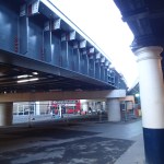
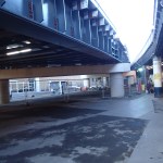
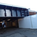
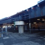
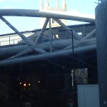
Steelwork At London Bridge
I took these pictures of the new steelwork at London Bridge station, that will carry the extra through tracks over Borough High Street and then to and from Charing Cross.
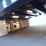
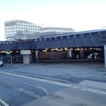

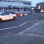
I had never used the mainline London Bridge station, until I moved to Dalston. But now, I use it regularly, as I just get a 141 bus through the City to and from the bus station by The Shard.
But don’t wait too long in the bus station, as there are sometimes down-draughts generated by the building.
What Is Happening At Highbury Corner?
Highbury Corner is a notorious junction, which I used to avoid when I drove, as it could often cause a lot of delay.
These pictures show barriers going up and the crossing outside Highbury and Islington station.


It would also appear that a new crossing is being built about fifty metres up Holloway Road. The guy in the paper shop told me that the main crossing will be closed and that the old Post Office will be demolished. I found this summary of the works here on the TfL web site. All the work is to replace a weak bridge and it says this about the old Post Office in particular.
The empty Post Office building needs to be demolished, and we expect to start work in the week beginning Monday 5 January 2015. The demolition work will be completed by March 2015.
We will make every effort to minimise the impact of noise and dust during the demolition.
The footpaths next to the old Post Office will remain open, although hoardings around the demolition site will make the footpaths narrower. This might create some crowding at busy times, impacting journeys in and out of the station.
In 2015, the main works to replace the bridge will begin.
I think it will be a good idea for pedestrians and drivers to avoid the area until 2017, when the article says that the bridge works will be complete.
The station is at a location where development would surely be worthwhile. Especially, if it put right all of the mistakes of the 1960s, which produced a Victoria Line station for the fit, agile and young. Below ground it’s a dump!
At least though it would appear that the western side of the roundabout will have reduced traffic levels and bus/Underground/Overground connections will be easier. The centre of the roundabout with its trees would also be opened up to the public.
My hopes for the bus/train interchange would include.
1. The 277 bus go right around to terminate in front of the station, ready to pick up passengers arriving at the station.
2. Easy interchange at the station from the 277 to either the 43 or the 271 to go north up Holloway Road towards Archway, Highgate and Barnet. At present you need to use two light-controlled crossings to cross two busy main roads, to affect the change.
3. The reverse journey on a southbound 43 or 271 to catch a 277 eastwards is probably more difficult, unless the buses cut through the western side of the roundabout.
But I think, I’m asking for too much!
I doubt though the development will be as grand as the original.

The Old Highbury and Islington Station
The entry on Wikipedia says this about the history of the station building.
The NLR station was damaged by a V-1 flying bomb on 27 June 1944, however, its main building remained in use until it was demolished in the 1960s during the building of the Victoria line. The original westbound platform buildings remain, as does a small part of the original entrance to the left of the present station entrance.
The Victoria Line might have had world leading automatic train operation when it opened, but most of the architecture and building of the stations, was some of the worst in the UK in the 1960s.
An Impressive Visualisation
The Croxley Rail Link is a major project to improve the links of the Metropolitan line into Watford and connect the line to Watford Junction station.
Out of curiosity I looked at this 3d visualisation of the new link.
I found it very impressive.
Note the following.
1. After Croxley station, the line bends away to the right on a viaduct.
2. At present the line goes straight on at this point to the current Watford station. This line will become a siding, when the Croxley Rail Link is built.
3. As the Grand Union Canal is crossed, this is in the area of this post.
4. Ascot Road station shown in the visualisation is now to be called Cassiobridge station.
5. The next station is Watford Vicarage Road, which serves the football ground and the hospital.
6. The existing Watford DC Line of the London Overground joins before Watford High Street station, from where the two lines share the same track to Watford Junction.
Hopefully, I’ll still be here and can try this route for real to get to the football ground in 2017.
But I don’t think that the project will be implemented as is currently planned. The Watford Observer is reporting that London Underground is taking over the responsibility for the project and I think this will result bin some changes, most likely for the better.
1. Some parties want Watford station to stay open. As it will be possible to run trains from the Croxley Rail Link through Rickmansworth and on to Amersham, could a shuttle be introduced between Amersham and Watford stations? There is a precedent for this type of arrangement in that there is a shuttle between Dalston Junction and New Cross stations on the East London Line. The main purpose is to increase the service frequency on the core of the line through the Thames Tunnel.
2. Both Amersham and Chalfont & Latimer stations are served by Chiltern Railways, who may want to put their view forward.
3. Could the changes mean that costs rise further and a delay is introduced into the project?
Two Nose-To-Nose Turtles
Turtle seems to be becoming the nickname for the new Class 68 locomotives.

Two Nose-To-Nose Turtles
I spotted these two in the sidings alongside the Chiltern Line. There will be a total of twenty-five delivered to the UK in the current order and they will be followed by the Class 88, which is a locomotive than can either use electrical or diesel power.
The purpose of the unusual power arrangement of the Class 88, is so that on a journey say from Felixstowe to Acton, it can use electrical power for most of the journey with short runs using the diesel engine at the start and finish. In passenger duty they could be used on a run like London to Norwich under electrical power and then under diesel power to Great Yarmouth.
The politicians may have dithered over electrification, so engineers have come up with an electric locomotive, that can jump the gaps.
Merry Christmas From Chiltern Trains
I photographed this at Marylebone.

Merry Christmas From Chiltern Trains
I’m surprised I haven’t seen this before as the Class 165 trains were built twenty years ago and have been refurbished since.
Would Extending The Gospel Oak to Barking Line Unlock Land For Development?
If the Gospel Oak To Barking Line (GOBlin) is extended to Hounslow, it looks like it will branch off the current line at Junction Road, to join the Midland Main Line through West Hampstead Thameslink and on to the Dudding Hill Line for Old Oak Common and Acton.
This map shows the lines to the east of Gospel Oak station towards Kentish Town.

Railways Between Gospel Oak and Kentish Town
The GOBlin runs across the top, with the other orange line being the North London Line. Across the bottom of the picture there is the Midland Main Line. The link between the GOBlin and the Midland Main Line is clearly shown., but note that the area to the east of this link is industrial. It is the headquarters and main London site of the Murphy Group.
Think about the area in the triangle defined by the railways to the east of Gospel Oak station and further east towards Kentish Town.
1. In my A-Z, the area is a big white space.
2. When Thameslink is complete, there will probably some release of land near Kentish Town station.
3. An extended and electrified GOBlin could have a station in this area, giving any new developments better transport links. This station could also give an interchange to the North London Line. This would be a better interchange than the current one at Gospel Oak station.
4. One of the reasons given for linking the GOBlin at Junction Road to the Northern Line at Turnell Park tube station, is to link the GOBlin to a North-South route. But an extended GOBlin going through a properly sorted West Hampstead Interchange, gives passengers access to a multiplicity of North-South routes, including Thameslink, Chiltern, North London line and the Underground.
5. Unless it is needed for freight trains, the stub of the line to Gospel Oak might be closed.
6. The northern part of the site could be linked in a sympathetic way to Parliament Hill Fields. There could even be a green walk to the new station, if one is built.
7. There used to be a link to allow trains coming west on the GOBlin to go South on the Midland Main Line. If there was a need for it, then it could be reinstated.
There is every reason to believe in the next few years, Transport for London will extend the GOBlin and if they do, this site’s development potential could be fully unlocked.
Would Reorganising Cross-Channel Freight Cut Illegal Migration?
People can argue about the advantages and disadvantages of migration into the UK.
But in my view one of the reasons for the high level of illegal immigration into the UK, is that it is a rich source of income for criminal gangs and probably money lenders in countries like Syria, Ethiopia and Somalia, which transport these migrants to the French ports. Never underestimate the role of money-lenders in these sort of enterprises!
Once in the ports, they probably only have one reliable way to get into the UK and that is to sneak or be welcomed aboard a truck. I have only heard very occasionally of an illegal immigrant trying to get into the UK in someone’s car.
So could we reorganise cross-channel freight to cut illegal migration?
It would be a good exercise to analyse truck movements through the Channel Tunnel and see how many could be replaced by a direct rail container transfer. It could be argued that jumping on to a train going at over a hundred kilometres per hour is not easy and this alone would cut the number who try to enter the UK illegally.
Could we also run the truck-shuttles from a dedicated truck terminal at a remote location perhaps fifty kilometres from the tunnel itself? I’ve heard drivers complain of bad facilities and not being able to stop before the tunnel, so this could be a lot better for the drivers. I’m sure the French have a really isolated spot close to the autoroutes. If someone thought about this sort of terminal, it could be made into a very secure and comfortable facility.
Obviously, we’d need a similar facility on the UK side! Manston?
Match Twenty-Two – Ipswich 2 – Middlesbrough 0
At one point, I thought I might miss this match.
But as luck would have it, I was on the 13:00 rather than the 13:30 train out of London, so the delay induced by signalling problems in the Shenfield area only meant I missed the first ten minutes or so of the match.
I’ll put in this quote from the Middlesbrough manager; Aitor Karanka, as it sums up what happened well.
Ipswich wanted it more than us. Murphy was first to the rebound for their first goal, Teddy Bishop at 18 years old was the best player on the pitch and Jay Tabb, at 5ft 5ins, scored with his head.
With a bit of luck, we’d have had a third, but a two-nil victory keeps us near the top of the Championship.
