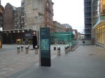
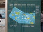
A Well-Mapped City Centre
Peterborough city centre is well provided with maps.
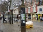
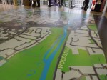
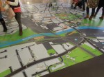
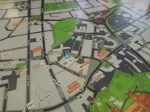

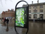
Some are typical of other cities, but in all my travels, I’ve never seen a map of virtually a whole city centre laid out on the floor, as the big map was in the Queensgate shopping centre.
One of the sections of the big map, shows the area, where my paternal grandmother was born in Whitsed Street.
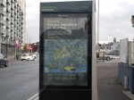
TfL’s Big Problem For 2015
look at this map for the London Overground.

TfL’s Big Problem For 2015
When the Lea Valley Lines come under the control of TfL in 2015, it’s going to give them a terrible problem about how they incorporate them into the maps.
But that’s only the start, as Crossrail will appear in 2018. But that has already shown on a map.

The picture shows the short-lived Lego version at Kings Cross station, this summer.
they’ve also got the problem of what to call Crossrail, if they do change the name. there has been some talk of calling it the Queen Elizabeth line, by such as Boris Johnson. I suspect, it’ll be called Crossrail or something similar like Across or EastWest line, if Boris doesn’t get his way.
If we called it Across, then Crossrail 2 could be called the Diagnonal line!
Of all the wonderful feats I have performed, I think yesterday I performed the most wonderful. I produced unanimity among 15 men who were all quarrelling about that most ticklish subject — taste
I think Brunel would have loved this problem, judging by this quote from the engineer.
It’s not a problem, I would like to have to solve.
Bordeaux’s Trams
Bordeaux has three tram lines that cross in various places in the city centre.


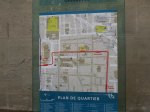


They are larger beasts than typically and in the city centre they run using a ground current collection system, so that there are no unsightly wires.
Every tram stop seems to havce a local map, but these could show a larger area, as two or three times, the place I needed was just off the map.
Greeted By A Map In Bordeaux
Virtually without exception at any London station, you get greeted by a map on a lith.

Greeted By A Map In Bordeaux
It was a surprise to be greeted in the same manner as I exited Bordeaux station.
Unfortunately, the detail was a bit fine and I couldn’t find the road, where my hotel was located.
But I was put right by the girls in the Tourist Office nearby and quickly bought a ticket for the trams and was on one to Quinconces near to the hotel.
Bilbao’s Heritage Signs
I would assume that this is a sign, which gives information about Bilbao’s heritage.
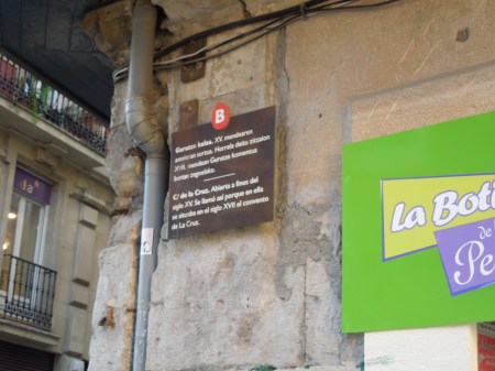
I can make a guess at reading Spanish, although the only thing I can read here, is that it is about a convent from the seventeenth century.
But then if Bilbao wants to attract more visitors, it really must improve its maps and information.
I know it’s all very political, but how many foreign visitors to the area, can speak the local language?
Walking Around Glasgow City Centre
I had an hour or so before I needed to get to Glasgow Central station, so as it was fine, I walked around looking at the buildings.
Glasgow is easy to navigate, as it has lots of wayfinding liths, just like London.


As you can see, some are megaliths and have a lot more than just a simple map and a few words.
Without doubt liths are the way to go.
This was illustrated, when I came across a group of students and a local, who were discussing in detail, the direction the students needed to go.
In my view, Glasgow’s liths may only have one problem, except for the misplaced Tourist Office.
And that is on Friday, with all the rain, they didn’t stand out, as the colours were too subtle. Perhaps, that is why London’s liths have yellow tops.
Welcomed To Glasgow By A Lith
On arriving at Glasgow Queen Street station, I was met by this obvious lith.

Welcomed To Glasgow By A Lith
From the map, I was able to locate the tourist office for more information.
A Solitary Edinburgh Lith
Walking along Princes Street in the rain, I came across this solitary lith called an Edinburgh Navigator.

A Solitary Edinburgh Lith
They are described here on the website of the company that designed them. For systems like this to be truly useful, there needs to be lots of them and they need to be all over a city and not just in the places, where visitors go. This is the opening paragraph from the web page.
Although Edinburgh has a number of renowned landmarks, research revealed that visitors still found some difficulty finding their way around. Our review of existing visitor navigation illustrated a lack of clear and integrated signage. The solution was to develop an entirely new visitor orientation system – Edinburgh Navigator.
It could be said of so many cities, all over the world.
Liverpool Tries Scrapping Bus Lanes
It is being reported on both BBC Breakfast and their web site, that Liverpool is scrapping bus lanes in a nine month experiment to see if it reduces congestion.
What Liverpool really needs is better information on how to use the buses and walk around the city, as I said here in this post. I didn’t get a reply. Unlike from Birmingham after this post.
Closer to home, I’m being seriously inconvenienced by road works in a bus lane, which has resulted in the closest stop to my house being closed. This means that when I return from the Angel with my shopping, I have to walk several hundred metres further. In a couple of cases, I’ve taken taxis home, to avoid the walk.
Hopefully, in a few days, we’ll be back to normal!
A Welcoming Lith In Geneva
This excellent lith with a map and information, was placed just out of Geneva station on the way to the lake.

A Welcoming Lith In Geneva
Every station exit in the world should have one!
I can’t find anything about these liths and their maps on the Internet.
