Offshore Drone Challenge Takes Off
The title of this post, is the same as that of this article on offshoreWIND.biz.
This is the sub-heading.
German energy company EnBW and its project partner, the German Aerospace Center (DLR), have published the conditions of entry and the specific flight tasks for the Offshore Drone Challenge (ODC) for the first time.
This is the first paragraph.
As part of the Offshore Drone Challenge, drone manufacturers and service providers are invited to demonstrate their technologies for transporting maintenance equipment to offshore wind farms.
It’s an interesting idea and would make a good television program.
But I suspect, that the winner will be a Ukrainian company, as recently, they’ve had a lot of practice delivering cargoes with a high level of precision into confined and difficult places.
Vattenfall Selects Norfolk Offshore Wind Zone O&M Base
The title of this post, is the same as that of this article on offshoreWIND.biz.
This is the sub-heading.
Vattenfall has selected Peel Ports as the preferred bidder, and its port at Great Yarmouth as the location for the operations and maintenance base of the Norfolk Offshore Wind Zone in the UK.
This was said about the competition to host the facility.
Vattenfall said that the competition was fierce to secure the agreement with an excellent bid from Lowestoft and Associated British Ports. With both ports offering excellent services it is clear that East Anglia’s potential as a superpower of offshore wind is secure.
I have a few thoughts.
Lowestoft In Suffolk And Great Yarmouth In Norfolk Must Work Together
This Google Map shows the coast between the two ports.
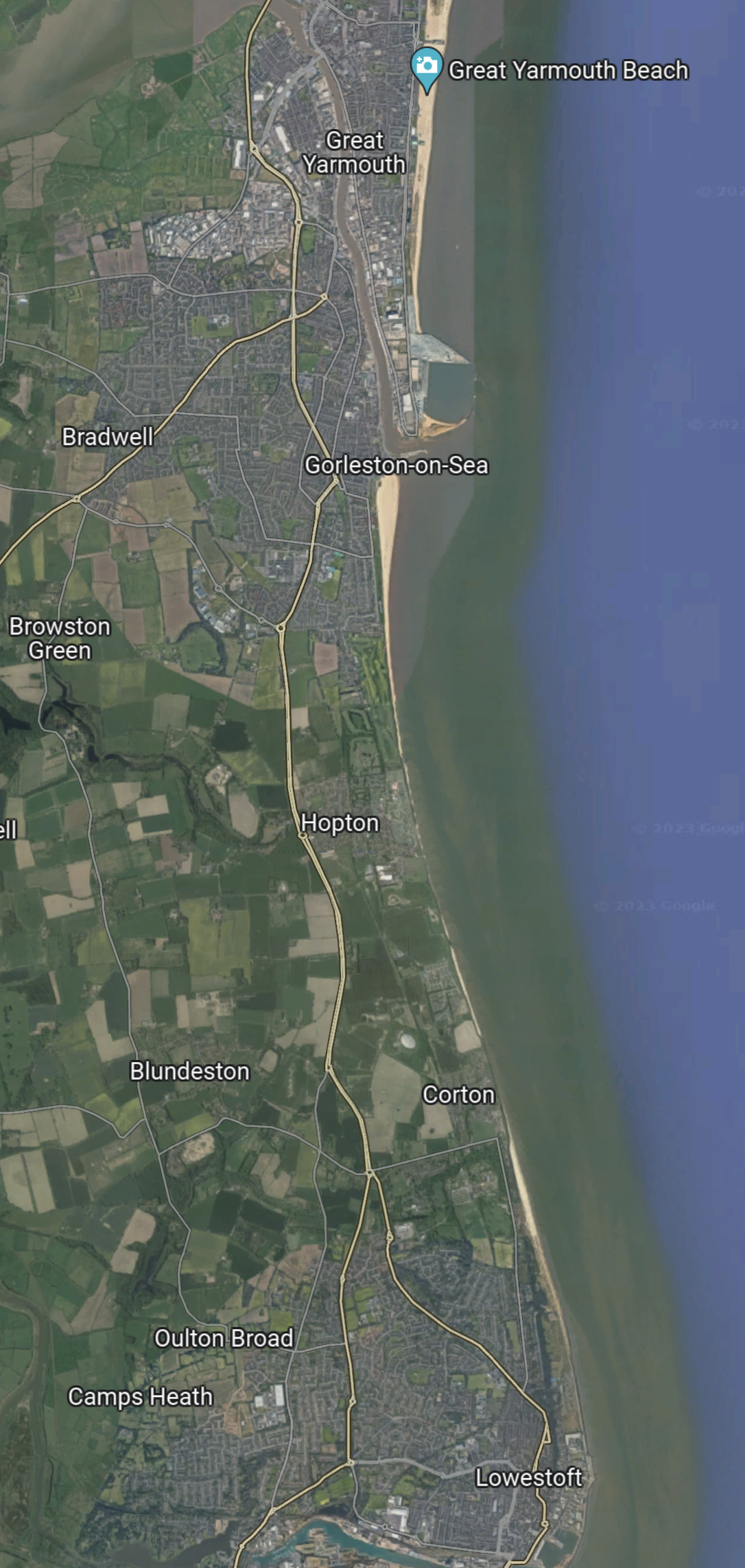
Note.
- Great Yarmouth is at the top of the map.
- Lowestoft is at the bottom of the map.
- The two towns are less than twelve miles apart.
- The Great Yarmouth Outer Harbour, is towards the top of the map.
The Google Map shows the port in more detail.
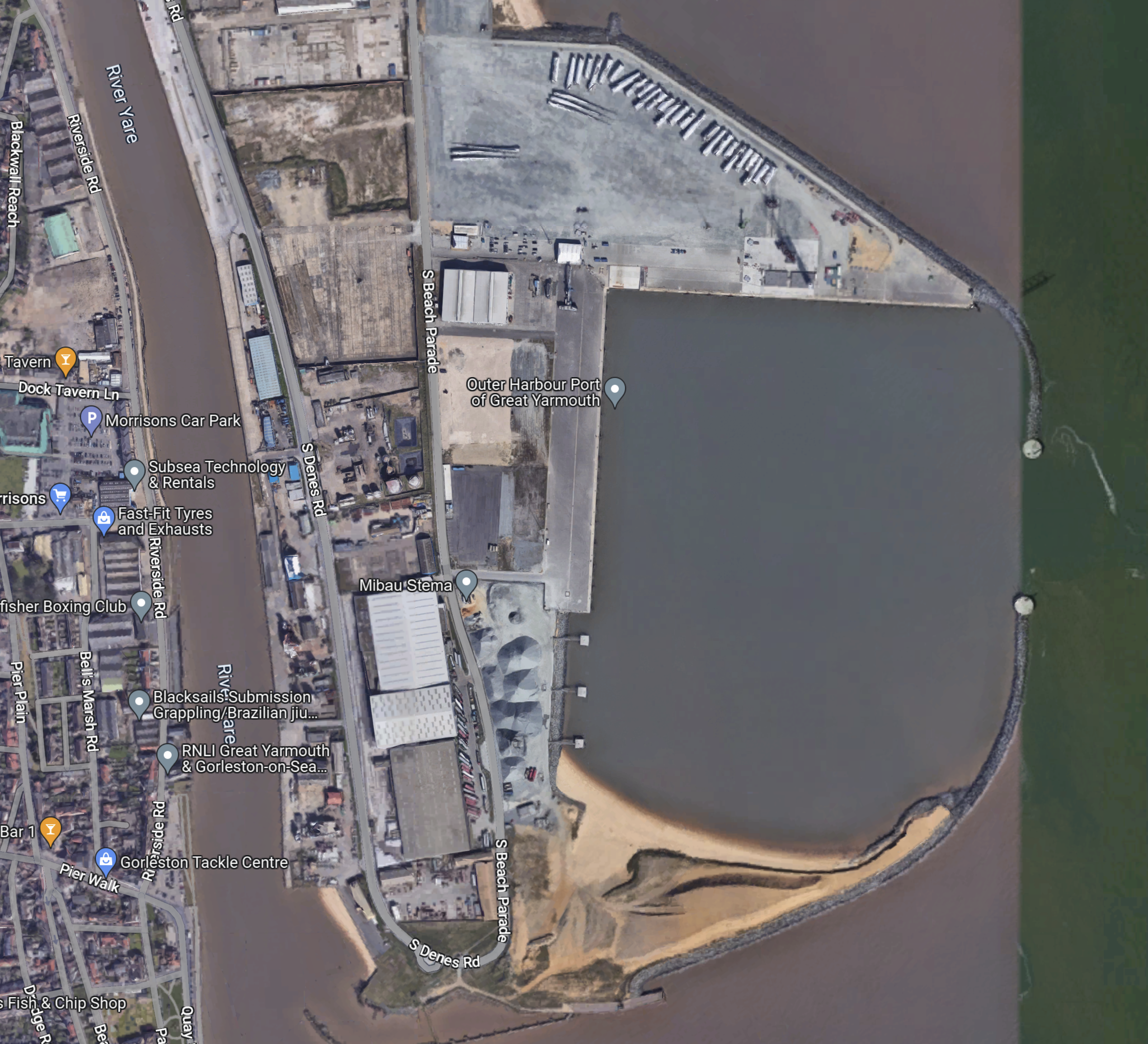
Note.
- Great Yarmouth Outer Harbour only opened in 2009.
- It has an average depth of 10 metres.
- It was planned as a container port, but the ships didn’t materialise.
- Some consider it to be a bit of a white elephant.
Could the Outer Harbour be used to assemble floating wind turbines?
I think it could but at present, there are no plans to use floating wind turbines off the coast of Norfolk.
I suspect though, if someone decided to build floating wind farms to the East of the Vattenfall’s Norfolk Zone fields, that Great Yarmouth Outer Harbour could be used to assemble the floating wind turbines.
This Google Map shows the Port of Lowestoft.
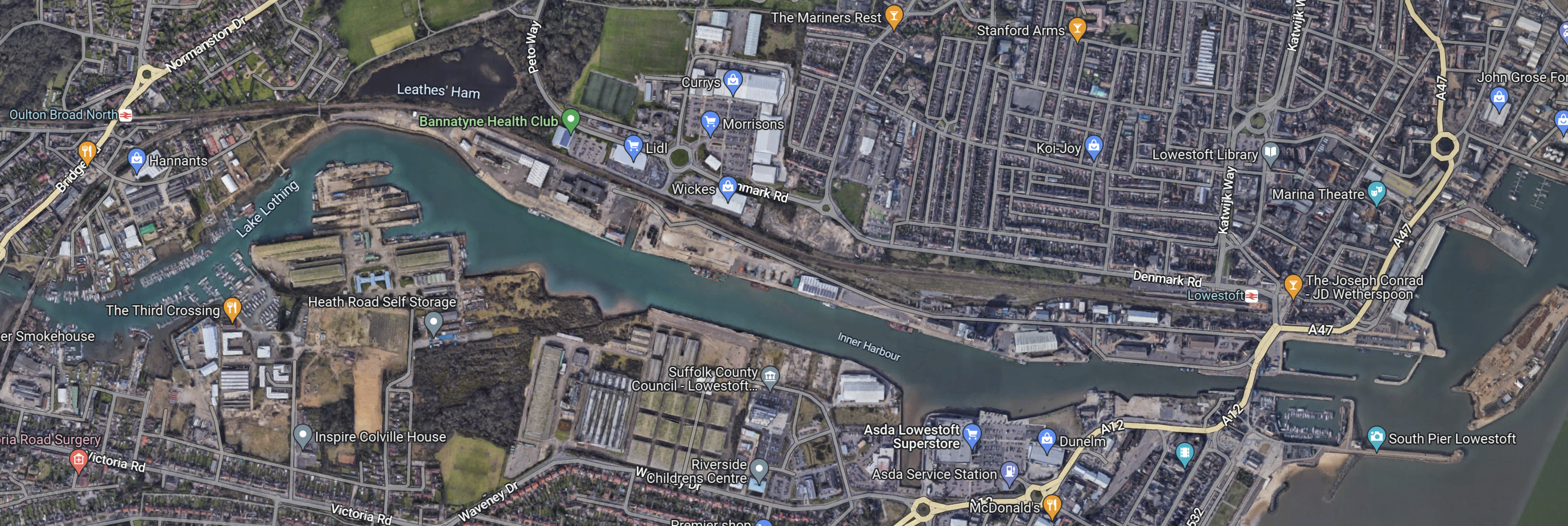
Note.
- There is over a kilometre of quays.
- It doesn’t have the water depth of Great Yarmouth.
- There is a lot of brownfield sites along the River Waveney.
- The East Anglia One wind farm is managed from Lowestoft.
Both harbours have their good and bad points.
- Both have good rail connections to Norwich.
- Lowestoft has a rail connection to Ipswich and has been promised a London service.
- Road connections to Ipswich and Norwich need improvement.
I suspect that it was a close contest, as to the port that got the Vattenfall contract.
A Lowestoft And Great Yarmouth Rail Connection
This map from Open RailwayMap between the two towns.
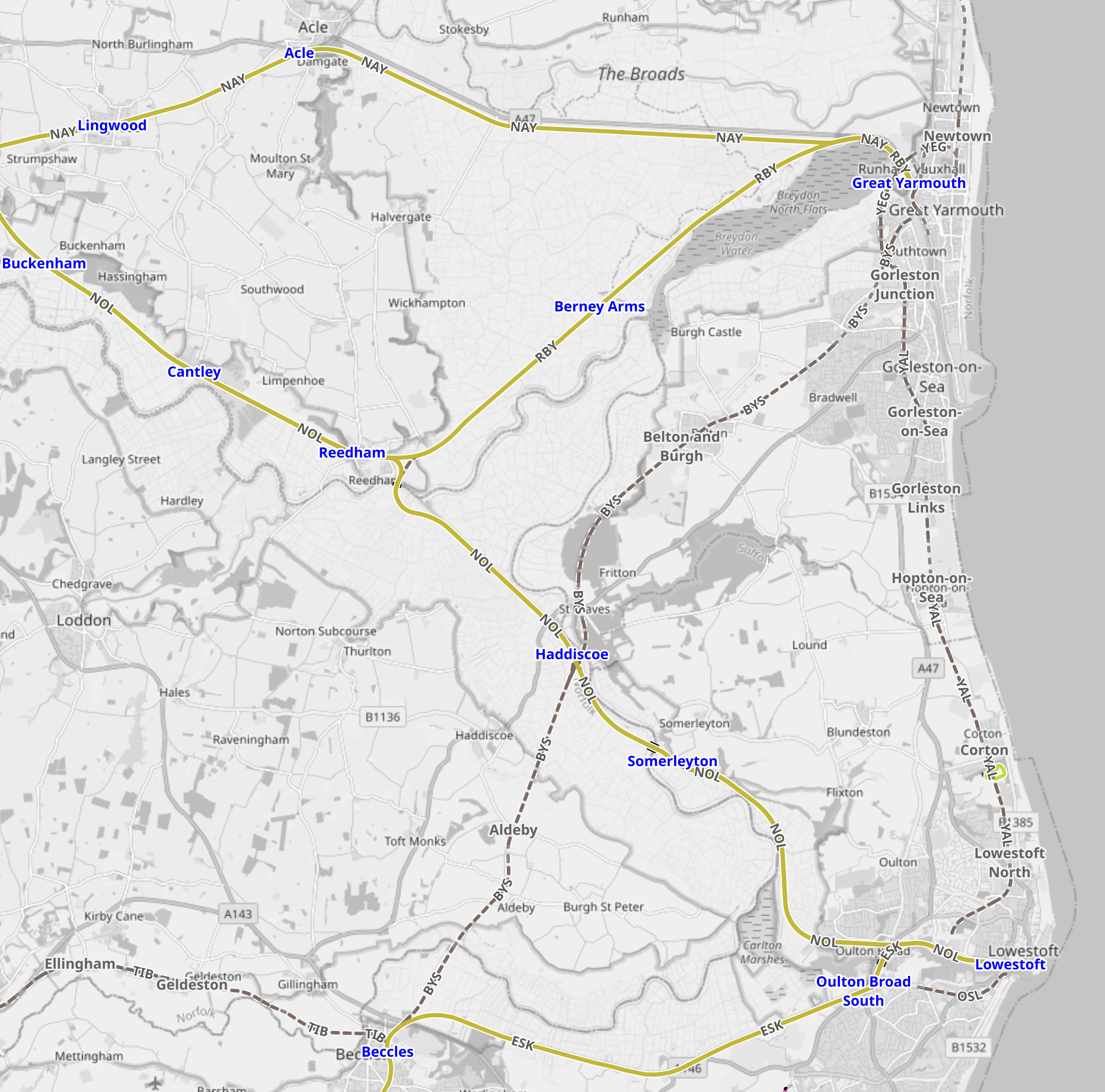
Note.
- The existing railways are shown in yellow.
- Former railways are shown in black dotted lines.
- There was even a railway along the coast.
The only rail connection between the ports is via Reedham, where the track layout is shown on this second OpenRailwayMap.
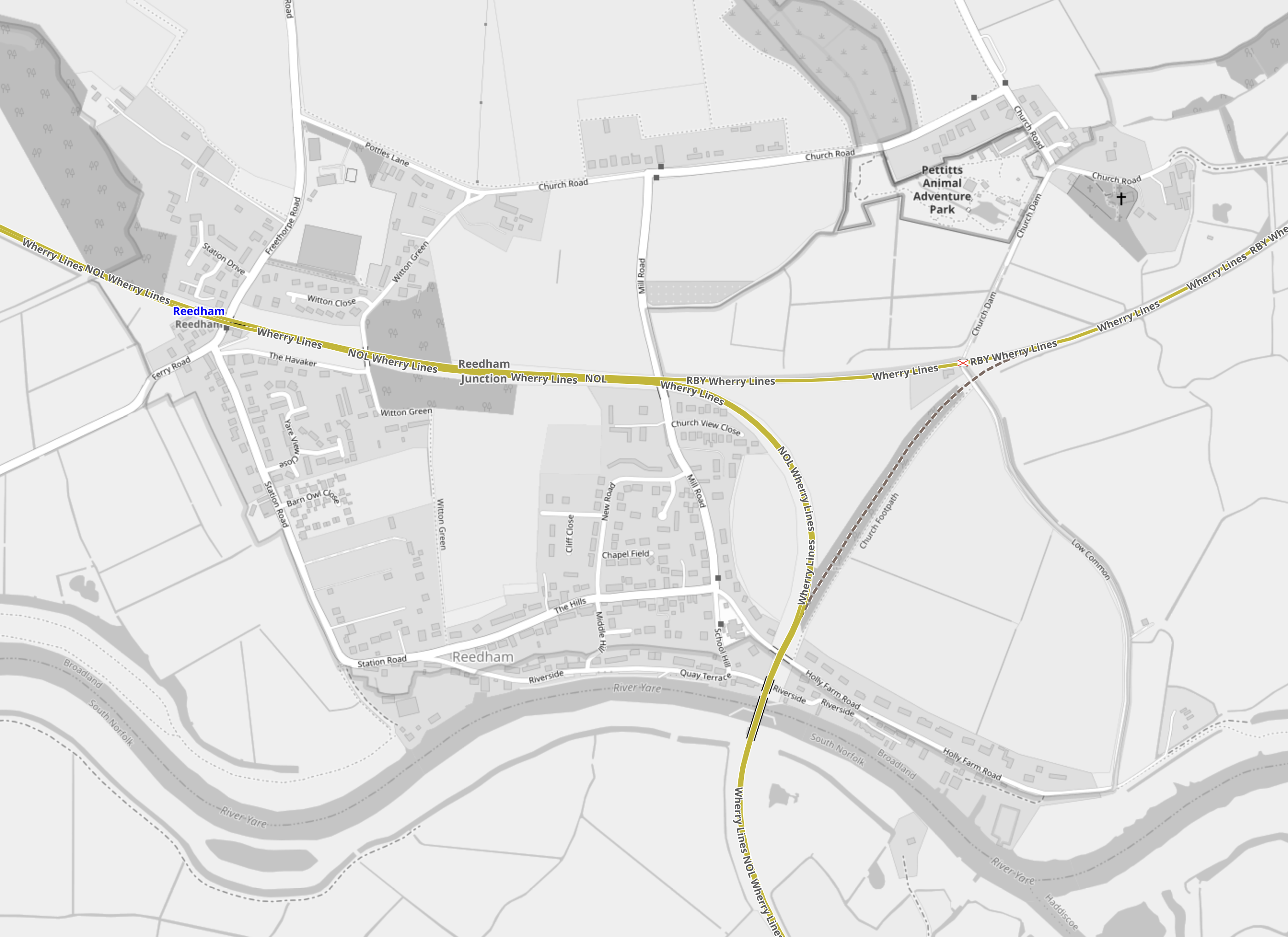
Note.
- Reedham station is in the North West corner on the line to Norwich.
- The line going North-East goes to Great Yarmouth.
- The line going South goes to Lowestoft.
There used to be a chord connecting Great Yarmouth and Lowestoft, but it was cancelled by Beeching’s grandfather.
There is certainly scope to improve the rail connection between the two ports.
- There could be a convenient change at Reedham, if the timetables were adjusted.
- Trains could reverse at Reedham.
- The chord could be reopened to allow direct trains.
It wouldn’t be the most challenging rail project to have an hourly rail service between the two ports.
A Lowestoft And London Rail Service
This was promised with a frequency of something like four trains per day (tpd)
I think it should run between London and Yarmouth with a reverse at Lowestoft.
Offshore Service Facilities
Some years ago at a wedding in The Netherlands, I got talking to a Dutch engineer, who had a lot to do with the creation of the Delta Works.
Also in The Netherlands, I visited the Watersnoodmuseum, which describes the floods in the Netherlands, that brought about the Delta Works.
So I was not surprised to see the spectacular offshore construction ideas talked about on the Offshore Service Facilities web site.
The site talks about a project to create a four GW wind farm, eighty kilometres off the coast, all serviced from an artificial island.
This is their overview of what they call the IJVER project.
IJmuiden Ver (IJVER) is one of the designated wind farm areas under the Dutch offshore wind road map 2030. With a capacity of at least 4 GW and a distance to shore of approximately 80 km, it is currently the largest foreseen Dutch wind farm zone, and the furthest from shore. The area also includes legacy oil & gas asset, including several gas pipelines that can be retrofitted to transport other gasses such as hydrogen or for CCS-purposes.
Note.
- 80 km. is not far offshore, when you consider the UK’s Dogger Bank C wind farm is 196 km from Teesside.
- There are depleted gas fields for storage and pipelines to transport gases to and from the shore.
This page describes the concept, starting with this introductory paragraph.
A multi-purpose island provides additional benefits over fixed offshore platforms (so-called jackets). It stimulates the energy transition, drives down the costs of the renewable energy transition, creates room for nature inclusive island design, facilitates Research & Development (R&D) and innovation, creates a safe working environment, as well as additional economic opportunities.
One feature they are proposing is an interconnector to the UK.
In Is There A Need For A Norfolk-Suffolk Interconnector?, I suggested that Bacton, Sizewell and Felixstowe could be places, where wind power from the North Sea were to be landed.
Distances to the IJVER island would be as follows.
- Bacton – 85 miles
- Sizewell – 77 miles
- Felixstowe – 92 miles
These distances are feasible for an interconnector.
There is this explanatory video.
Conclusion
My experience of the Dutch, their civil and marine engineers and their creations, indicates to me, that the Dutch could build an island like this.
Once you have built the island and it can stand up to the weather, you could of course fit it out how you want. Even with a football pitch, as shown in the video.
As with many ideas, the realisation of this concept will depend on the costs involved.
It should be noted, that some UK wind farms have been built with offshore substations, but nothing appears to be as ambitious as this idea and is probably based on proven oil and gas platform technology.
The Dutch also have plans with the Germans and the Danes to create the North Sea Wind Power Hub in the middle of the North Sea.
- This would probably connect to the UK’s Dogger Bank wind farms.
- It would feed electricity as required to the countries around the North Sea.
- Hydrogen could be created on the hub.
- Over a hundred GW of electricity could be generated according to some forecasts.
I like the concept of the North Sea Wind Power Hub and suspect that the Dutch will see it built.
