Barry Station To Go Step-Free
This document on the Government web site is entitled Access for All: 73 Stations Set To Benefit From Additional Funding.
Barry station is on the list.
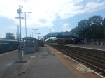
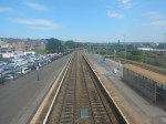
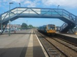
These pictures show the station and the current bridge,


Note.
- The trains were very crowded.
- The bridge is approaching its rust-by date.
- I think it is true to say, that the station buildings need a thorough refurbishment.
I have been sent a map of the proposed works and facilities for the South Wales Metro. This snippet shows the lines around Barry station.
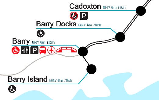
Note.
- The lines are not planned to be electrified.
- Barry station will get a new PRM-compliant bridge with step-free access between street and train.
- There will be an airport connection at the station.
I would assume that the station buildings will get the much-needed refurbishment.
Services To Barry, Barry Island, Bridgend and Penarth
The South Wales Metro services through Barry will be as follows.
- Services will terminate in the South and West at Barry Island, Bridgend and Penarth
- Services will terminate in the North at Coryton and Rhymney.
- There will be increased train frequencies.
Trains will be tri-mode Stadler Flirts with three or four cars, which will be similar to Greater Anglia’s Class 755 trains.
Judging by yesterday this capacity increase will be welcome.
Installing The Step-Free Access
It would appear there is plenty of space for a step-free footbridge with lifts.
In Winner Announced In The Network Rail Footbridge Design Ideas Competition, I wrote how the competition was won by this bridge.
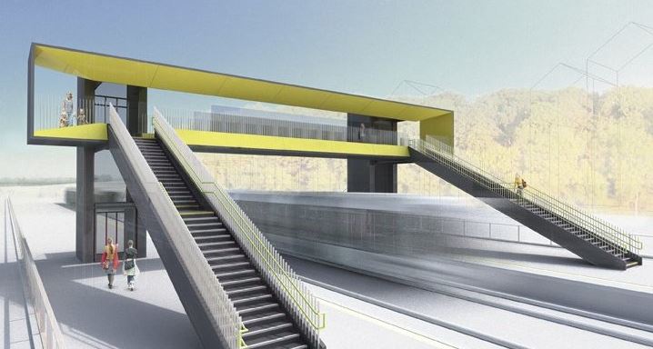
A bridge like this could be built at the other end of the station.
It would also be able to built it, without disrupting the train services or the passengers.
Once complete, the old bridge could be demolished or left as required.
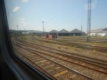
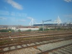
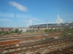
Electrification West Of Cardiff Central Station
These pictures show erected gantries for the electrification to the West of Cardiff Central station.

I have been sent a map of the proposed works and facilities for the South Wales Metro. This snippet shows the lines to the West of Cardiff Central station.
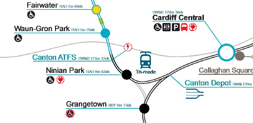
Note.
- Electrified lines are shown in blue and unelectrified ones in black.
- The South Wales Main Line is shown as a feint line going East-West to the North of Ninian Park station.
- Trains for Barry Island, Bridgend, Cardiff Airport, Maesteg and Penarth go via Grangetown station.
- Tram-trains for Radyr will go via Ninian Park station.
It looks like tram-trains emerging out of Canton Depot will have immediate access to 25 KVAC overhead electrification.
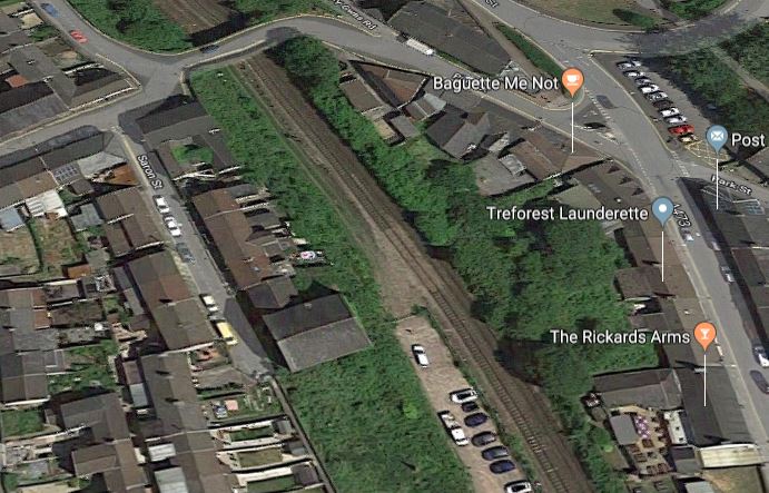
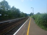
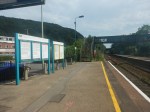
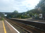
Treforest Station To Go Step-Free
This document on the Government web site is entitled Access for All: 73 Stations Set To Benefit From Additional Funding.
Treforest station is on the list.
These pictures show the station and the current bridge,


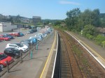

The bridge is not the easiest to cross and I tripped.
I wouldn’t like to cross it in the worst weather the Valleys could through at it!
Installing The Step-Free Access
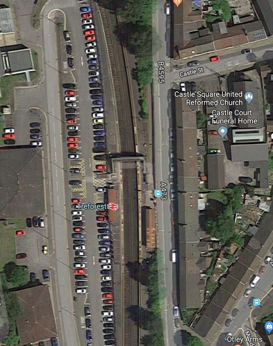
This Google Map shows the station.
In Winner Announced In The Network Rail Footbridge Design Ideas Competition, I wrote how the competition was won by this bridge.
I believe that one of these bridges could be built at the Northern end of the station.
- The Southbound platform could be widened if necessary.
- The Western end of the bridge might mean a few car-parking spaces would be lost.
- Disabled car-parking spaces could be close to the bridge.
- The bridge could be used to support the electrification in the station.
But most importantly, the bridge could be installed without any disruption to trains and passengers.
I have been sent a map of the proposed works and facilities for the South Wales Metro. This snippet shows Treforest station.
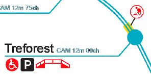
Note.
- Treforest station is shown with a PRM-compliant bridge and step-free access from street to train. The new bridge would deliver this.
- The station is shown electrified.
- A short section of line North of the station is without electrification.
This Google Map shows the area to the North of the station.
It would appear, that instead of rebuilding the bridge to squeeze the wires underneath, a short earthed section of overhead conductor rail would be used.
Conclusion
Using one of Network Rail’s new bridges at Treforest station, solves all the problems of the station and could even make the electrification easier.
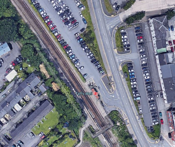
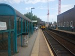
Is Taff’s Well Station Planned To Go Step-Free?
This document on the Government web site is entitled Access for All: 73 Stations Set To Benefit From Additional Funding.
Taff’s Well station is not on the list.
These pictures show the station and the current bridge,

Crossing the tracks on the current bridge, is no easier, than at Cathays and Treforest stations, both of which are going step-free.
This map is a schemastic of the South Wales Metro.

Twelve trains per hour (tph) will go through the station, when the South Wales Metro is fully developed.
Passenger numbers for 2017/2017 South between Pontypridd and Cathays are as follows.
- Pontypridd – 864,000 – Step-free
- Treforest – 752,000 – Going step-free by 2024
- Treforest Estate – 84,000
- Taff’s Well – 364,000
- Radyr – 539,000 – Step-free
- Llandaff – 483,000 – Step-free
- Cathays – 946,000 – Going step-free by 2024
Taff’s Well is the second least-used station.
But a doubling of the train frequency in the next few years, will certainly increase passenger numbers.
One guy, I spoke to said, that the station wasn’t busy.
I have been sent a map of the proposed works and facilities for the South Wales Metro. This snippet shows Taff’s Well station.

Note.
- There’s a lot of work to be done in the area.
- Taff’s Well station is shown with a PRM-compliant bridge and step-free access from street to train. The current bridge is not PRM-compliant.
- The station is shown electrified.
- Short sections of line around the station are without electrification.
I feel that to meet their objectives, the bridge needs to be replaced.
Installing Step-Free Access
In Winner Announced In The Network Rail Footbridge Design Ideas Competition, I wrote how the competition was won by this bridge.
I feel that, when Network Rail fully understand their installation procedures and costs, that a bridge like this could be used to replace the current monstrosity.
It also appears that the wires at Taff’s Well station will not be electrified, so could a bridge be used to hold up the overhead wires, that will guide pantographs through the station?
This Google Map shows Taff’s Well station.
The station has the common problem, of those that use the station as a Park-and-Ride have to negotiate the bridge one way.
Does the possibility of coming back from Cardiff, with lots of shopping, encourage shoppers to drive down the valley?
Taff’s Well station illustrates one of the benefits of the winning bridge design.
It could be built at the Northern end of the station, without disrupting the existing trains or their passengers.
I feel that Taff’s Well station would be ideal for one of the new bridges, even if it is not installed for a few years.
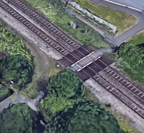
Electrification Through Taff’s Well Station
It is planned that electrification will be continuous through the station., which probably means that a new bridge with all the right clearances is desireable.
South of the station, there are a series of modern road bridges, which should have been built to give sufficient clearance for the 25 KVAC overhead electrification.
North of the station, there are two modern footbridges.
This is the one nearest the station.
And this is the more Northerly bridge.
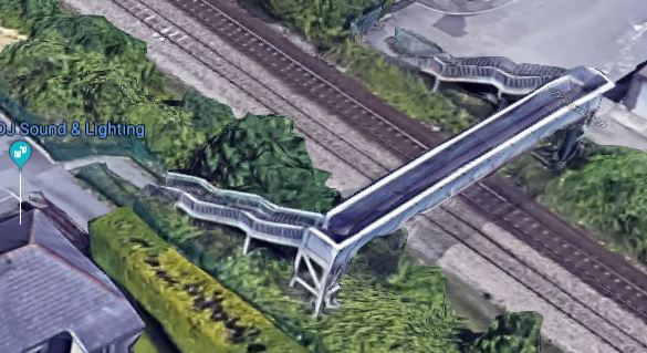
It appears that discontinuous electrification will be used on both bridges to make sure all safety clearances are met.
In an ideal world, the second bridge should surely have lifts!
Conclusion
Obviously, as the plans develop, we’ll know more about what will happen at Taff’s Well station.
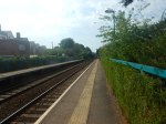
Cathays Station To Go Step-Free
This document on the Government web site is entitled Access for All: 73 Stations Set To Benefit From Additional Funding.
Cathays station is on the list.
These pictures show the station and the current bridge,


This Google Map shows the station and its surroundings.
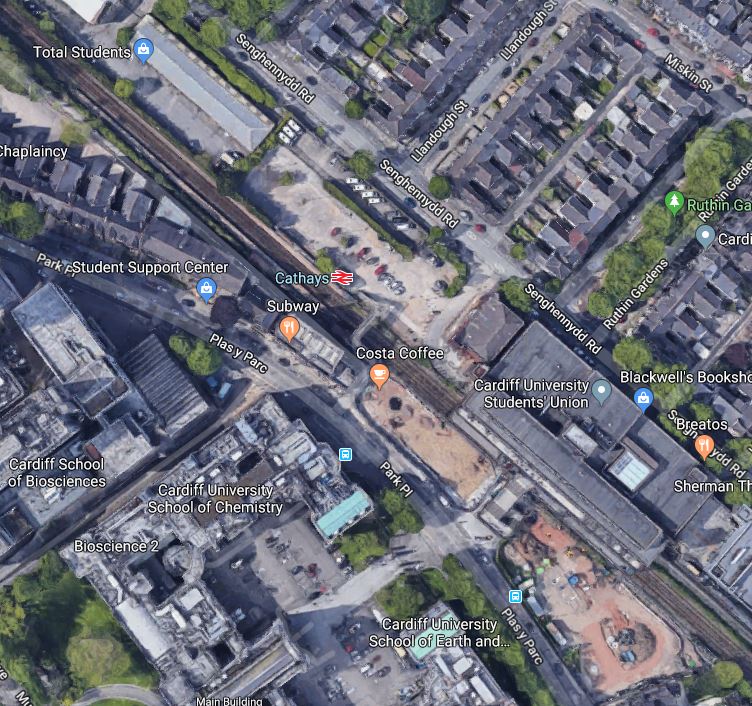
Note.
- As I went through I noticed a lot of development North of the station.
- The map shows developments to the South.
- There appears to be a lot of student accommodation in the area.
All this must add up to a large increase in passenger numbers at the station.
But the biggest driver of passenger numbers, will be the trains through the station, as shown on this map.
Twelve trains per hour (tph) will go through the station, when the South Wales Metro is fully developed.
- South to Barry Island, Bridgend, Cardiff Bay, Cardiff Central, Pearth and Rhoose Airport.
- North to Aberdate, Merthyr Tydfil, Pontypridd and Treherbert.
Cathays station will be busy, with a very busy bridge, handling twice as many trains, as it does now!
I have been sent a map of the proposed works and facilities for the South Wales Metro. This snippet shows Cathays station.
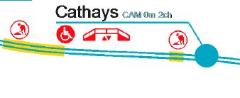
Note.
- Cathays station is shown with a PRM-compliant bridge with step-free access from street to train.
- There is a long and a short break in the electrification to the West of the station.
Cathays station is more complicated than it first appears.
Installing The Step-Free Access
I think that space for a footbridge could be tricky.
The platforms are narrow.
Is there enough space to add lifts to the existing bridge?
It could be difficult to keep the current bridge open, whilst a new one is installed.
In Winner Announced In The Network Rail Footbridge Design Ideas Competition, I wrote how the competition was won by this bridge.
It might be possible to squeeze in an asymmetric version of this bridge. Or one, where the steps went out to the side!
Electrification And Property Development To The West Of Cathays Station
To the West of Cathays station, Corbett Road crosses the railway., as this Google Map shows.
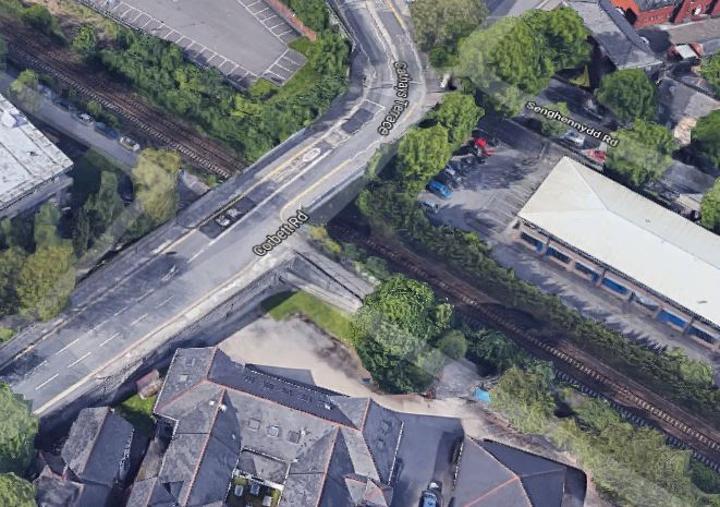
This is probably the shorter break in the electrification.
The second one could be more innovative.
This Google Map shows the railway, as it runs through Cardiff University between Cathays and Llandaf stations.
Note, what looks to be a large development site on the North side of the tracks.
Could it be that the University plans to build over the railway?
It would certainly maximise land use and perhaps make it easier for the University to construct the buildings it needs.
A New Station At Gabalfa
A new Gabalfa station is also proposed between Cathays and Llandaf stations.
Conclusion
It looks like there is a lot happening around Cathays station.
T
and there a
Industry Urged To Decide On Alternative Technology
The title of this post, is the same as that of this article on Rail Magazine.
This is the first paragraph.
The rail industry needs to decide on the right approach to alternative technology as soon as possible, to ensure the industry can continue to reduce emissions.
Speaking to the All-Party Parliamentary Rail Group, Anthony Perratt of the RSSB, outlined how there was a huge opportunity to replace ageing Sprinter trains with new units powered by alternative energy sources like batteries and hydrogen.
The Size Of The Opportunity
Sprinter trains in service of stored in the UK include.
- Class 150 – 135 x two-car, 2 x three-car
- Class 153 – 70 x one-car
- Class 155 – 7 x two-car
- Class 156 – 114 x two-car
- Class 158 – 147 x two-car, 21 x three-car
- Class 159 – 30 x three-car
These add up to 516 trains, with a total of 1035 cars.
In the Wikipedia entry for the Class 710 train, this is said.
TfL announced that it had placed a £260m order for 45 four-car Bombardier Aventra EMUs.
This works out at nearly £1,500,000 for each car of a modern train.
This means that replacement of the Sprinters, with new independently-powered trains, would be project of the order of £1.5billion.
That is a market, that would be very much desired by a train builder.
Battery, Diesel Or Hydrogen Power?
Diesel power is probably not a good idea, if it can be avoided.
The following points about hydrogen- and battery-powered trains should be noted.
- Most hydrogen-powered trains are battery-powered trains, with a hydrogen fuel-cell to recharge the batteries.
- Battery technology is improving fast.
- Systems to rapidly charge batteries will be available in a couple of years.
- Battery-powered trains can use existing electrification to charge the batteries.
- Hydrogen-powered trains may need a large tank for the hydrogen, which limits passenger capacity.
- Hydrogen-powered trains need a refuelling structure, which may be more difficult to install, than a charging system for battery trains.
I feel that innovative engineers will be able to find ways to enable battery-powered trains on routes that need independently powered trains.
Conclusion
I don’t think, that we’ll see many long-term applications of hydrogen-powered trains in the UK.
Warning As Electricity Cables Are Switched On In Manchester
The title of this post is the same as that of this article on Rail Advent.
This is the first paragraph.
Network Rail has warned members of the public to stay off the railway as new high voltage equipment goes live on the line between Stalybridge and Manchester Victoria.
It now looks like electric the current service between Stalybridge and Wigan North Western stations can now be run more efficiently by a Class 769 train, when these enter service.
If Network Rail were to get their skates on and electrify between Bolton and Wigan North Western stations via Lostock Junction, the talybridge and Wigan North Western Route could be run by electric traction.
This electrification of the Lostock Junction route, would also allow the Wigan North Western and Alderley Edge service to be run by electric traction.
Looking at Google Maps of the route, it appears that gantries are being or have been erected.
No Progress At Syon Lane Station
I visited Syon Lane station this morning and there has been no progress on the footbridge, that Network Rail say will be installed by late summer.
Over the weekend various works were done along the line, including some conductor rail replacement.
There’s another blockade next weekend, so I’ll see what happens then!
Conclusion
The longer it goes without any visible progress, does it make it more likely, that some form of prefabricated bridge will be assembled like giant Lego?
I can’t see how, if a traditional footbridge is used, it can be built to their timescale.
Sheffield Region Transport Plan 2019 – Hope Valley Line Improvements
The improvements to the Hope Valley Line are listed under Plans in the Wikipedia entry for the line.
This is said.
Network Rail, in partnership with South Yorkshire ITA, will redouble the track between Dore Station Junction and Dore West Junction, at an estimated cost of £15 million. This costing is based on four additional vehicles in traffic to deliver the option, however, this will depend on vehicle allocation through the DfT rolling stock plan. This work will be programmed, subject to funding, in conjunction with signalling renewals in the Dore/Totley Tunnel area.
Other proposals include a loop in the Bamford area, in order to fit in an all-day (07:00–19:00) hourly Manchester–Sheffield via New Mills Central stopping service, by extending an existing Manchester–New Mills Central service. Planning permission for this was granted in February 2018.
These changes to allow three fast trains, a stopping train and freight trains each hour were also supported in a Transport for the North investment report in 2019, together with “further interventions” for the Northern Powerhouse Rail programme.
So what does that all mean?
All of the stations mentioned like Dore & Totley, Bamford are at the Sheffield end of the Hope Valley Line, where it joins the Midland Main Line.
This map, which was clipped from Wikipedia, shows the lines and the stations.
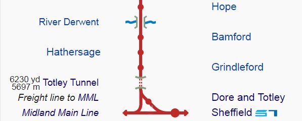
Note.
- The Midland Main Line runs South to North and West is upwards
- Dore West Junction is close to the Eastern end of Totley Tunnel.
- The Hope Valley Line is double track from Dore West Junction to the West.
- The Midland Main Line is double-track.
- Dore & Totley station is on a single-track chord, between Dore West Junction and Dore Station Junction.
- Another single-track chord connects Dore West Junction and Dore South Junction on the Midland Main Line.
I’ll now cover each part of the work in seperate sections.
Dore Junction And Dpre & Totley Station
This Google Map shows the area of Dore & Totley station and the triangular junction.
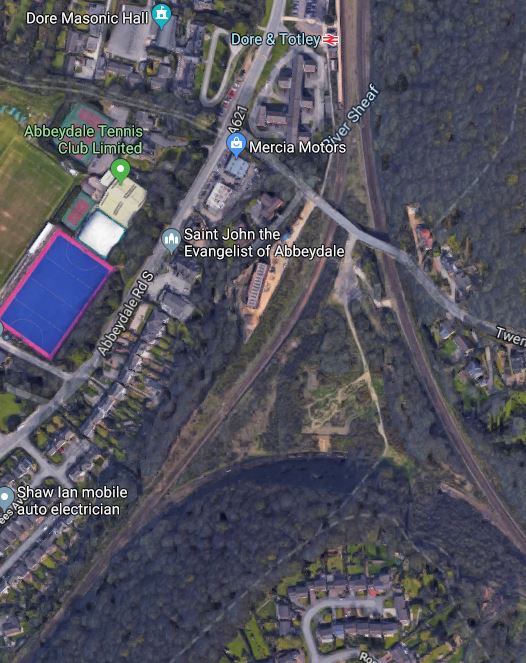
Note.
- Dore & Totley station is at the North of the map.
- The Midland Main Line goes down the Eastern side of the triangular junction.
- The Hope Valley Line goes West from Dore West Junction.
- The Midland Main Line goes South from Dore South Junction.
Network Rail’s plan would appear to do the following.
- Create a double-track between Dore Station Junction and Dore West Junction, through the Dore & Totley station.
- Add a second platform and a footbridge with lifts to the station.
Instead of a single-track line handling traffic in both directions, there will be a double-track railway with a track in each direction.
Capacity will have been increased.
In some ways Network Rail are only returning the station to how it existed in the past, so it shouldn’t be the most difficult of projects. But many of this type of project have surprises, so I’ll see it when the new station opens.
The Bamford Loop
On this page on the Friends of Dore & Totley Station web site, this is said about the Bamford Loop.
A Bamford Loop which is a place to halt frieight trains to allow passenger trains to overtake. This is east of Bamford station.
It is around a thousand metres long.
Flying my helicopter between Bamford and Heathersage stations, the track appears almost straight and adding a loop shouldn’t be that difficult.
The only problem is that there is a level crossing for a footpath at Heathersage West.
This will be replaced by a footbridge.
Benefits
The page on the Friends of Dore & Totley Station gives the main benefits of the scheme are to :-
- Increase the number of fast trains from 2 to 3 per hour
- Increase the stopping trains from 1 every 2 hours to 1 per hour
- To provide for 3 freight trains every two hours as at present.
- Allow trains of up to 6 cars to use the route
- Accommodate longer freight trains
- Improve reliability on the route
These seem to be fairly worthwhile benefits from a relatively simple scheme
