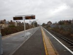
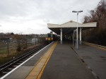
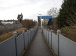
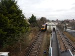
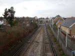
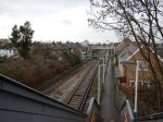
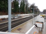
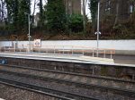
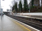
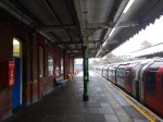
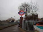
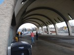
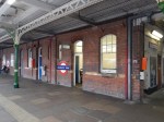
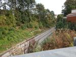
Is There A Worse Station Than This In London?
I took the last train for some time to North Sheen station, which I had been told was bad, but I couldn’t believe what I found.
This Google Map shows the station layout.
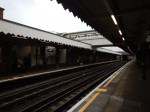
- It must have one of the longest lists of fundamental faults of any station.
- To get into and out of the station, you need to climb up and down a step footbridge.
- It has the worst step-free access I’ve ever seen.
- There were no staff.
- It has an inconvenient level crossing.
- There was no car parking or even anywhere to drop and pick up a passenger.
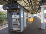
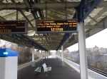
In some ways, what makes matters worse is that the station has ten-car platforms which at times must bring large numbers of passengers.
The only good thing about the station, was that a ticket machine was on the platform.
It is a truly dreadful station.
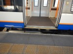
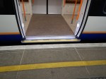
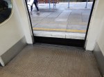
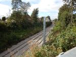
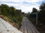
A Design Crime – Class 395 Train Platform Interface
I took these pictures of the step you need to ascend to get into a Class 395 Train.
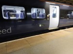
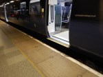
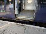
All of these pictures, were taken on platforms that were specifically built for the trains and no other train type calls at these station.
Perhaps my biggest gripe with these terrible doors, is that there is no wide door, which you would need for a large wheelchair.
These trains may have a high top speed, but they’re not designed for quick safe stops.
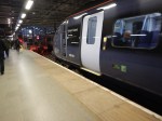
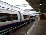
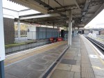
The Class 395 trains were built in Japan around 2009 and the Class 378 trains for the Overground were built around the same time.
Compare these pictures taken on the Overground with those above.
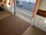
Note that the first two pictures were taken in a platform used by other train, so the access isn’t quite as good.
Perhaps Japanese railways don’t allow people in wheelchairs to use trains.
If they do, how come we get trains as wheelchair-unfriendly as the Class 395 train, which need a ramp to get the wheelchair on and off the train.
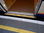
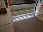
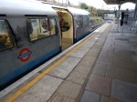
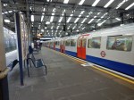
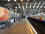
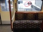
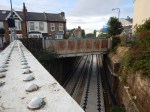
Up And Down The Bakerloo Line
These pictures were taken of access on the Northern reaches of the Bakerloo Line.


Note.
- I suspect that the Class 172 train, was getting ready to restart the service on the Gospel Oak to Goblin Line.
- The step-down into a 1972 Stock train.
- How a ramp is used with a Class 387 train.
- Queen’s Park station has good step-across access.
Good design can surely make the access better.
How To Build A Step-Free Access Ramp For A Train
This new ramp or Harrington Hump, has been built on Platform 1 at Canonbury station.

I didn’t use it, as I was going the other way.
It looks to be a very good design.
- Like all the best designs, it is simple.
- It is double-ended.
- It’s a gentle slope to ascend to train level, with no steps to trip on.
- It’s got seats to prop yourself on.
- It’s got a rail to hang on to.
- Those with poor eye-sight wouldn’t miss it and trip over.
- I suspect any sensible local builder could build one of these, from a kit of parts and instructions on a page of A4.
It looks to me like it is one of those classic engineering designs, that was developed using copious amounts of real ale, with everything written down on the back of fag-packets and used envelopes.
After my musings on dual-height platforms for the Bakerloo Line Extension, in How Will They Build The Bakerloo Line Extension?, I think that a modified version could handle the problems at stations on the Northern reaches of the Bakerloo Line, where 1972 Stock and Class 378 trains, share a platform.
Newbury Park Station
According to this article in the Ilford Recorder, Newbury Park station is going to be one of the first in the latest batch of stations to be given step-free access.
So I went for a look.


Note.
- Lifts can probably be added easily to the existing bridge.
- Lifts are certainly needed, ss I saw a couple of mothers struggling with buggies.
- The station buildings on the platforms have potential for making really nice.
- The barrel roof is not to my taste, and I would rejoice if it had to be demolished for health and safety reasons.
- The station is a Grade II Listed building.
It is certainly an unusual station.
Using Southern Crossrail Lite
On my trip to Shepperton today, I went from and to Waterloo station for the Shepperton Branch Line.
For both journeys, I used the route between London Bridge and Waterloo East stations, that some want to use as part of Southern Crossrail.
Going to Waterloo, I started at Farringdon, and this waan’t a good place to start, as I didn’t have a clue to the best way and neither did the London Underground staff.
So I took the Metropolitan to Moorgate and hopped South on the Northern Line to London Bridge, from where I had three routes.
- Jubilee Line
- Train from London to Waterloo East.
- Bus
At a pinch, I could walk along the Embankment
I suspect that when Crossrail and Thameslink are fully open, there will be a better route, between Farringdon and Waterloo.
- Crossrail to Paddington, then Bakerloo Line to Waterloo.
- Crossrail to Tottenham Court Road, then Northern Line to Waterloo.
- Thameslink to London Bridge, then train to Waterloo East.
As a special Crossrail-Bakerloo pedestrian tunnel is being built at Paddington, that may be the best way. I wrote about this in Paddington Is Operational Again.
My route to Waterloo worked today, as did the route home after a raid on the excellent Marks and Spencer at Waterloo. The only problem was that a 141 bus to my house, had broken down and I had to wait at London Bridge.
I tend to use a 141 bus to and fropm London Bridge, as one stop is in the forecourt of the station and the other is less than a hundred metres from my house.
So how could this abbreviated Southern Crossrail Lite route be improved?
- The London Bridge end works well, as generally all trains for Waterloo East station turn up on Platforms 8 or 9, which are the two sides of the same island.
- Only one up escalator at London Bridge was available and I have a feeling, there could be a bit of a reliability issue.
- I used a lift to go down coming back, to avoid walking to the escalator, and the lift was the sort of size the Victorians used because escalators weren’t in common use until later.
- The lift was certainly big enough for a cricket team and all their kit.
- There needs to be better connection between main line and Underground at London Bridge. I suspect this will get better, as more of the station opens.
- For this route four trains per hour, as you get on a Sunday, aren’t enough.
- At Waterloo East, the walking route could be improved.
- Waterloo East needs a Next Train To London Bridge Indicator.
- Waterloo has twin up and down escalators between the main concourse and the walking route, which is more than enough. Especially, as they were all working!
But I did notice several passengers used the route from London Bridge to Waterloo East stations, including at least two couples with children in pushchairs.
This new Southern Crossrail Lite is going to prove an invaluable alternative to the Jubilee Line.
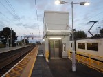
An Updated Manningtree Station
I stopped off at Manningtree station on the way to the football last night to have a look at the new step-free subway and perhaps buy a drink in the buffet.
Having a drink en route to Ipswich, is probably a good idea at the moment, as Ipswich station is being updated and there is nowhere between the station and Portman Road to buy one.
These were the pictures I took.
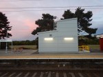


Note.
- There is a loop on the Northern side of the station, which has been modified to create a short through Platform 4.
- The subway is fully operational, although signs say there is still work to do.
- The subway is ideally placed for a passenger to get off a Norwich-bound train, walk to the subway and cross underneath the lines to either the station exit or a train on the Harwich branch waiting in Platform 1.
As to the buffet, it wasn’t worth a visit, as the cider, which is so important for coeliacs, was rubbish.
The New Manningtree Depot
This article in Rail News says this about the new Stadler Flirts ordered by Greater Anglia.
The trains will be maintained at the existing depots, including Crown Point at Norwich, and also at a new depot at Manningtree which is to be built on a former industrial site alongside the main line.
This Google Map shows the area.
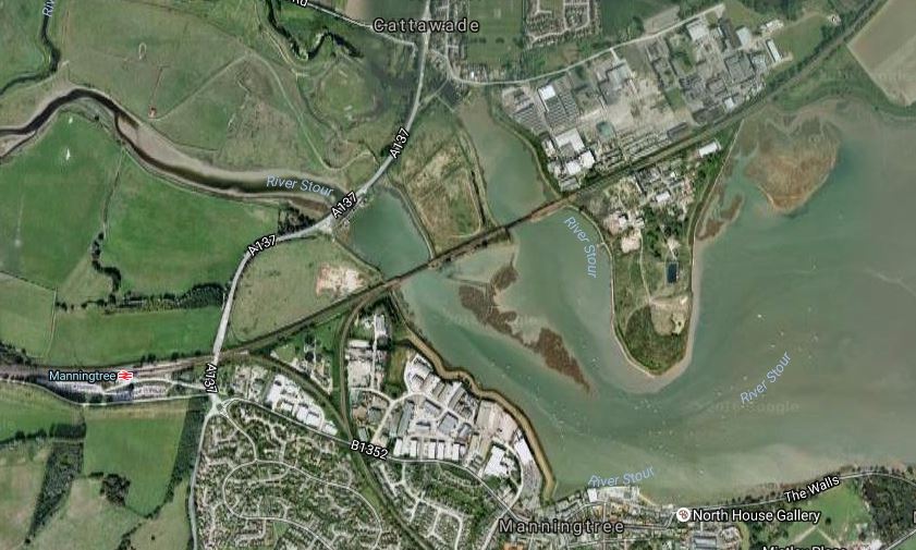
Manningtree Depot Site
The Great Eastern Main Line crosses the map, with Manningtree station clearly marked.
Going East, there is a fully-electrified triangular junction, where the Harwich Branch or Mayflower Line joins the main line, followed by two crossings of the River Stour.
Then to the North and South of the main line, there is a large derelict industrial site, which I suspect will be the location of the depot, as it is the only place that fits the Rail News description.
I suppose the biggest question about this depot, as will it be North or South of the main line. But there is masses of space and I wouldn’t be surprised to see the site used for other commercial purposes as well.
Other questions might include.
- Will housing be developed in the area? Probably not, as it could be liable to flooding.
- Will the depot be developed with limited overhead wires for safety and ascetic reasons?
- Will a station be built to serve the area?
- If one is, will it have extensive car parking in the space available?
- How will environmentalists react to development of the deelict industrial site?
I do suspect locally, that the new employment opportunities will be welcomed.
The Manningtree Station Level Crossing
This Google Map shows a close-up of Manningtree station.

Manningtree Station
Note how the road crosses the railway at the right. Wikipedia says this about the crossing.
A second peculiar feature just east of the station is a combination of a road underpass and a level crossing. The underpass has limited height and the parallel level crossing is needed to permit higher vehicles to cross the railway.
This article on the BBC has a video about the crossing, which surely makes a case for improvements.
The title of the article is Bus trapped on Manningtree railway crossing: Driver fined says it all.
Luckily, the only damage was to the driver’s wallet!
With increased traffic on the railway lines through the crossing, will we be seeing improvements to this crossing, which surely must cause problems for trucks at times?
Platform 4
I think we’ll be seeing more use of Platform 4 as the lines get busier and the traffic gets faster.
- I have read somewhere, that the updated Platform 4 will be used as a means of allowing fast trains to overtake. I suppose a Colchester to Ipswich local train could wait in Platform 4, whilst a London to Norwich express went through on Platform 3.
- Perhaps the line could be used by trains going down the Harwich Branch to improve connectivity to the branch with London to Norwich expresses in the Peak.
- I also think for operational reasons train companies like to have a station before a depot, so that any sleeping passengers can be woken and offloaded.
But seriously, why would you get Platform 4 ready for increased use and not use it?
The Future Of The Mayflower Line
Wikipedia for Harwich Town station says this about services on the line.
As of December 2015 the typical weekday off-peak service is one train per hour to Manningtree, although there some additional services at peak times. Trains generally call at all stations along the Mayflower Line; some are extended to or from Colchester and/or London Liverpool Street.
I suspect that an ideal service would be at least two trains per hour (tph) on the line, which were timed to connect with fast services on the Great Eastern Main Line at Manningtree.
Currently there are direct trains in the Peak to and from Liverpool Street. The train, that I got to Manningtree last night was actually going to Harwich, after dividing into two at Colchester, with the front half of the train going on to Clacton-on-Sea.
In the new franchise, Greater Anglia will be running new Aventra trains on the branch. As they are buying five and ten-car trains, I would assume that the five-car version will work the Mayflower Line.
- This will mean that there will be an increase in capacity on the line.
- There will also be a large increase in comfort.
- I would assume that two five-car trains are easily joined and separated to provide shared services, such as I experienced last night.
- As the journey between Harwich Town and Manningtree takes twenty-two minutes, two trains would be needed to run a 2 tph service.
Running 2 tph may be a problem, as the electrification is one of the Treasury’s budget specials. Wikipedia says this.
The line diverges from the Great Eastern Main Line at Manningtree and is double-track for passenger services as far as Harwich International where connecting ferry services are available to Hoek van Holland and Esbjerg. Beyond Harwich International, the original second track remains in place as a through-siding, but only the “up” (Manningtree-bound) line was electrified and that section to Harwich Town is bi-directional.
But Bombardier may have a solution, in that the line was used for the BEMU trial, where a Class 379 train with an onboard battery, ran one way on the overhead wires, charging the battery at the same time.
As all Aventras will be wired to accept onboard energy storage, will we be seeing battery power on the Mayflower Line?
I think the answer is yes!
On my way to Manningtree, I was sitting next to a lady going to Harwich and when I talked about the battery train test of twenty months ago, she said she’d ridden the train and liked it. She didn’t qualify her initial statement with any negative statement.
Progress Through Walthamstow – 28th September 2016
These pictures show the Gospel Oak to Barking Line through Walthamstow.

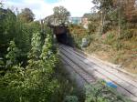


Note.
- It looks like both tracks have been mostly relaid.
- The slab track under Pretoria Avenue, where it was put in due to a sewer being beneath the bridge.
- There is also slab track at the other end of this section of line, but I suspect, it’s covered with ballast.
From what I could see at Blackhorse Road station, there doesn’t appear to be any foundations for lift towers or ramps to create step-free access to the Overground platforms. On Network Rail’s Access for All list of improvements. the improvements at Blackhorse Road station are listed as Future Planned for 2017/2018.
As the new Class 710 trains will start running in 2018, surely it would be good planning to at least do all the work needed on the Overground platforms now!
Or is there some rule, which says that when you make one line at a station step-free for all, you must do that for all lines?
It is interesting to look at this Google Map of the station.

The Victoria Line station is the square building to the North East of the obvious GOBlin station, with the space between the stations being just grass and some bushes.
In one of the pictures, there is a lot of work going on in this area.
Could it be, that there is a route to create a lift shaft from somewhere in this area, that goes both down to the Victoria Line and on the surface connects to the ticket hall and the bridge over the GOBlin?
It could also be work associated with a new chiller described in this article on the TfL web site., which is entitled Innovative new fan chiller to help customers beat the heat.
If you look inside the station, you’ll see that the escalators down to the Victoria Line platforms, start just to the West of the bridge over the Overground.
Without more information, it’s difficult to work out what is happening.
But it would surely be a good idea to do all the work at the same time and get the station step-free before the GOBlin starts running electric trains.
Escalators In Station Design
Over the last few months, I’ve been to three brand-new stations.
- Kirkstall Forge, which I nwrote about in Kirkstall Forge Station
- Lea Bridge, which I wrote about in The People Of London Welcome Lea Bridge Station
- London Bridge, which I wrote about in Details Of The New London Bridge Station
All are well-built stations with step-free access.
But I have to ask, if Kirkstall Forge and Lea Bridge would be better stations with a more favourable financial outlook, if they had escalators instead of stairs to the bridge.
Consider.
- London Transport used escalators extensively before the Second World War and few think that was wrong.
- Escalators must surely attract more paying passengers.
- If escalators are used could we see them paired with inclined lifts. to perhaps create more compact stations.
Quite frankly, Kirkstall Forge and Lea Bridge have boring layouts. I do think, we need more innovative station designs.
In some ways the most interesting station I’ve seen in the last few months is Welwyn Garden City, where the station is on the First Floor of a Shopping Centre. The main escalators and lifts are in the Shopping Centre with individual lifts and stairs to the platforms.
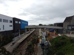
Abbey Wood Station – 9th June 2016
I took these pictures at Abbey Wood station.

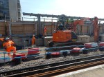


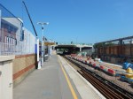
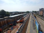

If you look at the various pictures I have taken over the past months of this station, the station is progressing and the builders seem to be managing to always have a working station amongst all the construction work.
Certain factors have helped in this important aim.
- The previous station was unloved by everyone and had absolutely no architectural merit.
- There are no heritage issues.
- Good design of a temporary step-free pedestrian bridge, that appears to be morphing into a permanent one, has aided passengers.
- There always seems to be cheery staff on hand for lost and puzzled passengers.
- Traffic is heavy in the area, but not unmanageably so.
But I think most importantly, the Crossrail portal is some distance away from the station, keeping the two projects effectively separate.
Compared to some station rebuilds, I’ve encountered in the past, so far it has been a textbook example of good project management.
