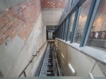
Underneath And Above The Arches
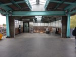
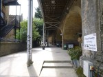
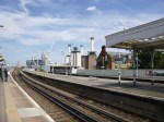
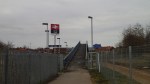
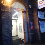
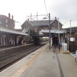
London Fields station has improved in some ways with Overgroundisation since I wrote Before Overground – London Fields in September 2014.
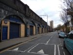
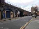


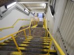


It just shows what you can do with an army of cleaners and painters. And a touch of Overground Orange!
But there is still the problem of step-free access to solve.
This Google Map shows how difficult this could be.
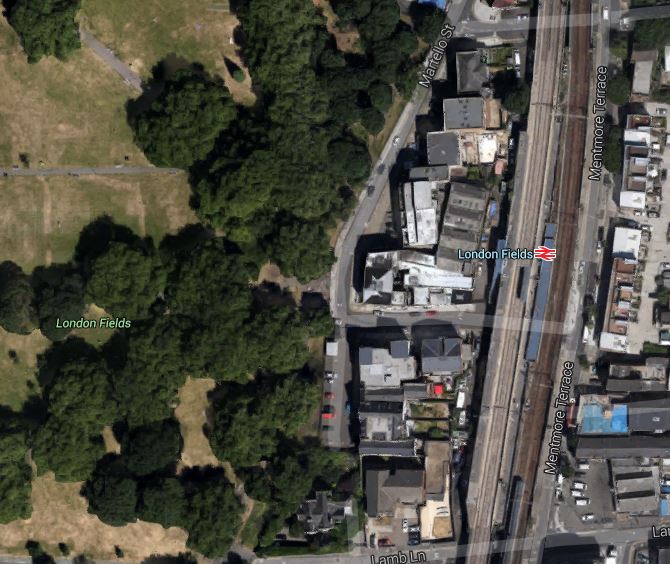
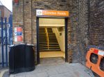
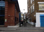
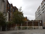
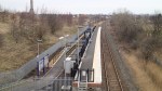
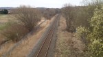
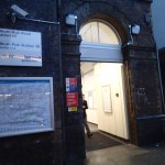
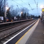
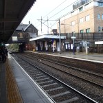
London Fields Station
The site is cramped, with the platform and stairs for the Liverpool Street platform squeezed between the slow and fast lines.
I wouldn’t be surprised if Transport for London, put the addition of step-free access to this station at the very back of the queue.
Unless of course, they could persuade a developer to do something very imaginative and expensive, which they can market as having its own station and a large park with an Olympic-sized swimming pool.
Crossrail 2 October 2015 – Dalston Station
Are us plebs in humble Dalston going to get one of the best and busiest stations on Crossrail 2?
I wrote that opening statement in jest, but think about the proposed combined Dalston station’s position in London’s rail network.
- It is the most Northerly station before the two branches to New Southgate and Broxbourne link under Stamford Hill.
- Dalston Junction (Or is it Dalston South?) gives an escalator connection between Crossrail 2 and an up to twenty-four trains an hour to South-East London on the East London Line.
- Dalston Kingsland (Or is it Dalston North?) gives an escalator connection between Crossrail 2 and all those trains on the North London Line.
So Dalston will become the important interchange for a large number of cross-London journeys. Raynes Park to New Southgate may well be direct, but so many journeys like Norwood Junction to Brimsdown will just be a single change at Dalston.
Crossrail 2 will put Dalston in one of the most important places on the map of London’s rail network.
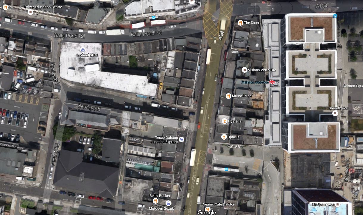
Crossrail 2’s proposal for Dalston Station
This Crossrail document is entitled Dalston Station.
The proposal in the document starts like this.
The Crossrail 2 station at Dalston would be a double-ended station, with an interchange at Dalston Junction at the southern end, and an interchange with Dalston Kingsland at the Northern end.
So we get three stations in one, which also means that at last there will be a true dry interchange between Dalston Kingsland station on the North London Line and Dalston Junction station on the East London Line.
This map from the document shows the layout of the two existing stations and their connection by means of two two-hundred and fifty metre long underground Crossrail 2 platforms.

Crossrail 2 Dalston Station
It would appear that two shafts will be sunk to the Crossrail 2 tunnels.
- The Southern one would be in the Tesco Express or the bar next door,
- The Northern one would be just to the north of Ridley Road in the block containing the NatWest Bank.
Note how much of the route of the Crossrail 2 tunnels, runs on the East side of Kingsland High Street, under the Shopping Centre and the new flats. The tunnels will be at least twenty metres down just to get past High Speed One, which runs under the North London Line and Dalston Kingsland station, so any older buildings will be well above any Crossrail 2 construction.
I would also suspect that High Speed One also makes designing and construction of the Kingsland end of the station challenging.
The Work Sites
The Crossrail 2 proposal for Dalston station is nothing but ambitious and to build it there will be no less than five work sites.
- Site A – Would be used as the main site for construction of the station tunnels and southern station shaft
- Site B – Would be used for construction of a new Crossrail 2 station entrance and ticket hall. The site includes properties on the southern side of Bradbury Street.
- Site C – Would be used for construction of the northern station shaft and escalator connection to the Crossrail 2 platforms
- Site D – Would be used for construction of a new bridge providing access from the new ticket hall to the westbound platform at Dalston Kingsland
- Site E – Would be used for construction of a station entrance and ticket hall, for interchange with Dalston Junction station.
But I would be very surprised if the work wasn’t phased so that the work-load in Dalston was spread and work is performed in a logical order.
Dalston Kingsland station is a dump compared to Dalston Junction station, with all the charm, access problems and convenience of a Victorian tube station.
In a reasonable world, it would be replaced now, whether Crossrail 2 is built soon or postponed to the Twenty-Second Century.
The need for a Site D indicates that a new bridge will be built across the station to give access. As Site D is currently in the construction site for new flats called Fifty Seven East and Dalston Kingland station desperately needs step-free access, then surely this bridge should be built now!
To further assess the work-sites, I walked along Tottenham Road to Site A, then crossed to Site E, before walking up Kingsland High Street to look at Sites B, C and D.


There is certainly, a lot going on and if everybody gets it right, it can become one of London’s more important High Streets.
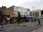
What Is Already Happening In Kingsland High Street?
Before I come to my conclusions, I’ll say a little about what is already happening.
- Plans may have been published to rebuild Dalston Kingsland station.
- There are more projects to build flats in the area. London needs housing and as these will be designed so they don’t affect Crossrail 2, they will go ahead.
- The Dalston Kingsland Shopping Centre is supposed to be being rebuilt.
- There are also plans to improve the pedestrian flows on what is a very congested road for walkers.
- There will be other changes due to the Cycle Superhighway passing about fifty metres to the west of Kingsland High Street.
So in say four or five years time, we should have a better High Street and Kingsland station, whether Crossrail 2 is coming or not!
Conclusions
So what are my initial conclusions?
- Because of the station design, there will need to be some demolition at both current stations.
- Site A needs a full rebuild, as it has very little property of merit and I certainly wouldn’t miss the Subway, Tesco and the bar on the end. The shaft to access the new platforms, will probably be in the middle of the current Tesco.
- Site B is in a bad state with much of the property locked up. Some of the properties on Bradbury Street will need to be demolished to rebuild Dalston Kingsland station, let alone build the Crossrail 2 station. Will anybody mourn?
- Site C is where the Northern shaft will be. There will be some demolishion.
- Site D is a curious one in that it is inside a site that is being developed.
- Site E is where the new entrance to |Dalston Junction and the Crossrail 2 station is going to be built. I’d have hoped that the Crossrail 2 passages would have been laid out in the redesign of the Overground station. What’s been published gives me doubts!
- How much of the demolition will be of properties worth keeping? Those that I photographed didn’t shout save me!
There are three sites on the High Street, which will be very much affected by the rebuilding of Dalston Kingsland station and building of Crossrail 2.
- Site A, where the Southern shaft for the station is located.
- Site B, where the Northern entrance to the new station is proposed, is substantially closed at present.
- Site C, opposite Dalston Kingsland station that will contain the Northern shaft for the station and escalator connection to the Crossrail 2 platforms.
All could be developed with new residential or commercial properties on top.
I believe that the proposed plan for the new Crossrail 2 station should be treated as what it is, just a proposal.
Or at least as far as the above ground presence is concerned.
All three sites could be developed as welcoming portals to enhance the public transport system as it serves the area around Dalston.
I would apply the principle, that access to the Crossrail 2 station, should be available from both sides of Kingsland High Street at both the Northern and Southern ends.
I will now look at each site in detail.
Site A
This is a Google Map showing Dalston Junction station and Site A.
Dalston Junction Station And Site A
Note the station and its towers above in the East and Bentley Road Car Park in the West. You should be able to pick out the Tesco Express on the Kingsland Road.
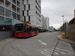
I walk to Dalston Junction station most days to get the Overground. But it is not a good walking route.
- The pavements along the Balls Pond Road and Kingsland Road are very narrow and you are squashed between traffic and large numbers of walkers.
- It is easier to walk up Tottenham Road, but as with the other route crossing Kingsland Road can be difficult.
- If you live to the South West of Dalston Junction station, it is probably easier to walk to Haggerston station, as I do sometimes.
- It is particularly difficult to cross at the cross roads where the Balls Pond Road meets the Kingsland Road.
As the frontage of Site A on the Kingsland Road will have to be substantially demolished, in an ideal world, provision would be made to access the escalator and lift connection to the Crossrail 2 station from the West side of Kingsland Road.
Perhaps when the frontage of Site A on Kingsland Road is rebuilt after Crossrail 2 works have finished, it should provide a subway under the road to the station and the sort of shops and cafes, that passengers like in their stations.
It would welcome those, who live to the South West of Dalston Junction station to the area, just as Dalston Square on the other side of the station welcomes those from the South East.
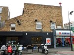
Site B
This is a Google Map showing Dalston Kingsland station and Sites B and C.

Dalston Kingsland Station And Sites B And C
Site B is to the North of Dalston Kingsland station, on the West side of Kingsland High Street.
Note that this map was made before the construction of Fifty Seven East started, as Peacocks is still on the West side of Kingsland High Street.
I feel that if they rebuild Dalston Kingsland properly, then then are possibilities to not only build residential or commercial development on top of Site B, but over the railway and the station as well.
Land is expensive and the station occupies almost as much space as Fifty Seven East, so surely a similar sized development over the station would be a welcome addition to London’s housing stock.
I would also hope that the design of the station includes the following.
- A step-free subway under Kingsland High Street to Ridley Road Market. This is probably a given, as the escalators to Crossrail 2 go down from Site C.
- As the station is close to the Cycling Superhighway, I suspect that it will be heavily used by cyclists, who would need lots of secure bike parking.
- Personally, I would like easy walking access along Bradbury Street as I regularly walk to Dalston Kingsland station along that route.
There are certainly lots of possibilities to make the existing Dalston Kingsland station a welcoming North West gateway to Crossrail 2 and Kingsland High Street.
Site C
This is a Google Map showing Dalston Kingsland station and Sites B and C.
Dalston Kingsland Station And Sites B And C
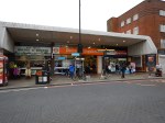
Site C is to the North of Dalston Kingsland station, on the East side of Kingsland High Street. The NatWest bank, which is at the Northend of Site C is indicated.
Any development on this site must enhance the Ridley Road Market and provide that gateway for those travelling to and from the North East of the station.
It is essential that there is an entrance to the station on the East side of Kingsland High street, to give good connections to the market and the Shopping Centre.
My Ultimate Test Of The New Station
My ultimate test of the new Dalton station would be on a cold and wet day, to have the ability to arrive at Dalston Kingsland station on the North London Line, go down an escalator to Crossrail 2, where I can walk along to the Southern End, go up the escalator and exit the station on the West side through a rebuilt Site A.
And do it pushing my yet-to-be-born great-grandchild in a buggy! The spirit of my grandmother, who was born opposite Dalston Junction station would be very pleased!
The Inclined Lift In An Improved Greenford Station
I visited Greenford station in January 2012, just after Transport for London announced that the last wooden escalator would be replaced with an inclined lift.
The lift has now been installed.


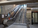

I rode down and then used the escalator up.
It is impressive and you do wonder how many other stations could have this type of lift installed.
This article on the Crossrail web site, entitled Crossrail and TfL to Install First Incline Lifts in UK Public Transport, says this.
Crossrail and Transport for London (TfL) today awarded a major contract to Kone for around 50 lifts for the new Crossrail stations as well as five lifts for Bank, Greenford and Hammersmith Tube stations.
Crossrail will pioneer the use of incline lifts to deliver step-free access at two of the major central London stations. Four innovative incline lifts will run alongside escalators at Farringdon and Liverpool Street Crossrail stations where it is not possible to install vertical lifts. London Underground will also install an incline lift at Greenford station by 2014.
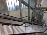
My gateway to the Victoria Line; Highbury and Islington could be a possibility, but one of the station staff told me, that the space at the bottom of the current set of two escalators and a fixed staircase is very small and fitting a third escalator is impossible.
But it might be possible to squeeze in a much needed inclined lift. Note that the lift doesn’t intrude into the circulation space at the top and bottom of the stairs.
I suspect that Transport for London will be watching the Greenford installation with more than a usual interest.
They’ve certainly got several stations with both an up and down escalator and a stairway between that could be possibilities for conversion to fully step-free by the use of an inclined lift.
The station I could have used more times than any other; Southgate has the required space between the escalators, but as it is a Grade 2* Listed building, I can’t see the heritage lobby allowing even a well-designed and tasteful inclined lift into the Jewel of the Piccadilly Line.
But Bounds Green, Manor House, Turnpike Lane, Walthamstow Central and Wood Green could be ones to upgrade.
A Four-Poster Station
When most railways in the world were built, no-one bothered about the disabled, the elderly and people pushing prams or trailing heavy cases, so station design was based around able-bodied people.
There were examples, like Caledonian Road, where the step-free access is up with the best of modern practice, but stations like that are a rarity.
In my visits around the country, I’m increasingly finding stations where there are several lifts, often made by the same company who made the stairlift advertised by Dame Thora Hird. I don’t know the cost of lifts but it strikes me that they must make all of these lift installations value for money.
Over the last few weeks, I’ve come across several places in this country, where two lines cross at an angle on different levels, where a connection might be of value to passengers.
The link between Hackney Downs and Hackney Central stations, is such a connection and it would appear to be successful. I’ve certainly not read any criticism in the media on either operational or aesthetic grounds. I’m sure if an incident as small as a child dropping and losing a ten pence piece had happened, there’d be headlines all over the place blaming Boris.
In Birmingham, there is the Cross-City Line, which conveniently passes in a cutting under Birmingham Moor Street station after stopping at New Street station. But there is no connection.
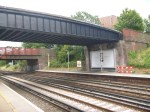
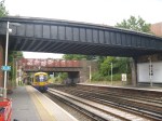
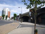
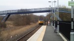
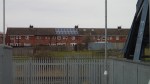
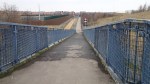
Then today, I was at Brockley, where in their Transport Infrastructure Plan for 2050, Transport for London are proposing a Brockley High Level station.
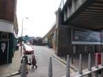
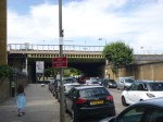
Brockley station sits underneath and is crossed by the Bexleyheath Line and these pictures show the station and the line crossing above.
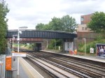
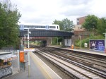
This Google Map shows the two lines crossing.
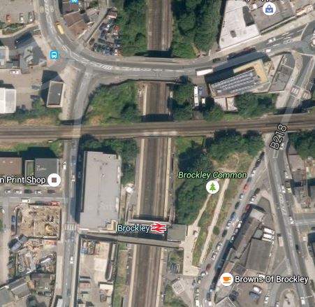
Brockley Station
There was a station called Brockley Lane on the Bexleyheath Line, but it closed in 1917.
I believe that modern structural engineering would allow the addition of two platforms to the sides of the rail bridge carrying the Bexleyheath Line. From the look of the bridge, it seems to be in very good condition.
In the case of Brockley station, the current platforms already reach under the bridge and to connect the two pairs of platforms. There would be four lifts with one in each corner. So there would be a lift between both North-South platforms and both East-West platforms! At Brockley, because the height between the two levels isn’t too great, stairs could also be provided if it felt passenger traffic required it. Some form of alternative way of getting off the high level platforms would be needed for emergency reasons.
The advantages of this approach are.
1. There is no serious track changes necessary at Brockley, as the new platforms are built alongside an existing rail line, but obviously there would need to be some signalling work.
2. The lifts would be the standard structures we see all over the UK rail network, modified to fit the application.
2. All interchanges will be step free.
3. As much station infrastructure can be provided on each platform, as it felt the passengers would need, thus keeping costs to a minimum. At Brockley, perhaps a shelter and a refuge for the staff, would be sufficient.
4. If gated access was not provided to the two high-level platforms on the Bexleyhealth Line, a safe Emergency Exit would probably meet the needs of evacuation.
The only disadvantage I can see, is that the two high-level platforms would need to be well-sheltered, as I suspect, it could be very cold and blowy up there at times.
In all my travels, I’ve never seen a station designed like this. Although some of the stations on the Docklands Light Railway like Deptford Bridge feature platforms suspended alongside the railway with access at both ends. But the budget there didn’t stretch to four lifts! That station incidentally is suspended on a bridge across a major road.
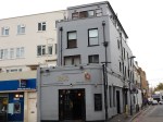
Battersea Park Station Revisited
I crossed the river by getting a train from Battersea Park station.
It certainly isn’t one of London’s better appointed stations!


It certainly isn’t one of London’s better appointed stations, with dangerous stairs and narrow platforms! Or one with the best signposting and information.
With all the development going on in Battersea, surely if any station needs a refurbishment it is this one,
A Benefit Of The Hackney Downs/Central Link
I don’t pay for my public transport in London, as I have a Freedom Pass, but most people get charged. The cost is very often an important factor for passengers.
This article in The Wharf explains how for some passengers the new walkway at Hackney will save them money, by helping them to easily avoid Zone 1. The article says this.
Funded by Transport for London (TfL), it means passengers at Hackney Central can now easily access trains to north London or Liverpool Street from Hackney Downs, while those at Hackney Downs have fresh options to travel eastbound to Stratford.
Previously passengers had to travel into Zone 1, incurring a higher cost for their journey, or walk 600m.
The article also uses the phrase Hackney Overground interchange. I wonder how long it is before, TfL investigate a new name for the whole complex.
Perhaps it should be one station, as after all the walk between Hackney Downs and Hackney Central is probably about the same length, as some of the longer walks inside the Underground at stations like Bank, Green Park and Kings Cross St. Pancras.
It’s now step free, which can’t be said for some of the Underground treks.
The Connection From Waterloo East Station To Southwark Tube Station Is Only For The Young, Fit And Agile
My mother’s advice as a Ponders Plonker (her words) from North London, advised me never to go South of the Thames as you’d get lost or have trouble.
Today, I wanted to do a bit of shopping, as one does, and thought I’d go to Bluewater for a change, as I needed a John Lewis, a big Marks and Spencer, and preferably a Carluccio’s for a pit stop. Westfield doesn’t have a John Lewis, Eastfield is a gluten-free desert and Oxford Street is often crowded.
So Bluewater seemed a good idea at the time! It was as I got all I needed and the Shopping Centre was very quiet.
For Bluewater, you go to Greenhithe station and get a bus, but today there had been a derailment on the North Kent Line at Charlton as reported in this article in the Standard, so my preferred route to Greenhithe via the Overground and the DLR to Greenwich or Woolwich Arsenal was blocked. So I had to go to Charing Cross station to get a direct train to Greenhithe via Sidcup or some such place in the wilderness that is South London.
I got to Greenhithe and Bluewater with just the odd delay and after a successful shop, I returned to Greenhithe with a bag from M & S, to be told that there were still delays, but a direct train to Charing Cross would be arriving in six minutes.
So I took it and was treated to a tour of places I didn’t know. I had hoped the train would stop at Lewisham, so I could cut off the corner using the DLR to Shadwell and then the Overground to Dalston Junction for a bus home.
But it didn’t!
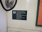
So I decided that as Waterloo East station has an interchange with Southwark station on the Jubilee Line, that it would be easier to change there and go to Canada Water for the Overground.
Southwark station was built for the Jubilee Line Extension in 1999, so I assumed that it would be an easy modern connection with a full spectrum of stairs, escalators and lifts.
First, I had to walk to the far end of the platform and then descend a long flight of fairly steep steps to a concourse below. I’ve certainly been on worse flights of steps in the Underground, but it didn’t prepare me for what I would encounter. Instead of an escalator from the concourse to the Jubilee line platforms, I found that the down escalator was under repair and I would be expected to descend a set of steps you’d more likely find in the Swiss Alps.
There wasn’t even a warning like there is at Hampstead tube station, but it was certainly more difficult than the steps there.
So I turned back and asked the guy on the gate, where the Way Out was. But there isn’t one! He told me, you had to go back to the platform and then use the bridge to Waterloo. So I had to climb back up the first set of stairs and in the end got a train to Charing Cross to come home by means of the District Line and the Overground.
My company, Metier Management Systems supplied Artemis software to do the project management for the Jubilee Line Extension. I have heard some odd stories about this project which had to be finished before the Millennium, so that the Great and Good could get to the Dome.
The guy on the gate did tell me that Transport for London tried to get an entrance to the concourse, but the residents objected. Whoever heard of a train station without a Way Out to the street?
At the present this interchange is an accident waiting to happen and there are no signs discouraging those who are not of a supreme fitness level from taking the route.
There are signs pointing to the Jubilee Line on the platforms at Waterloo East and after going through the barriers for those at Waterloo East, you are opposite the barriers for Southwark Tube station, which is only accessible by the extremely steep stairs.
Something needs to be done!
I could have probably managed it, if I wasn’t carrying my bag from Bluewater.
But I am a person, who doesn’t take unnecessary risks.
James Cook Station – The Reinvention Of The Halt
Simple stations or halts, were once very common on UK railways. These pictures show James Cook station in Middlesbrough, which is a new small station, that opened in May 2014.
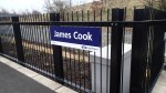


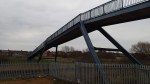


As the trains stopping at the station have conductors to sell tickets, there is no ticket machine, but there is a smart shelter, a help point, a destination board, a step-free bridge and ramps to the single platform.
James Cook station is the first construction in the possible creation of a Tees Valley Metro, which may see other new stations created or old ones reopened.
Surely, some of the ideas used in the design of the single platform James Cook station could be used at several places on the Tees Valley Metro and the wider UK rail network.
Incidentally, is there another station named solely after a person?
Brondesbury Station
Broundesbury station is one of the twenty-six to be given upgraded access.

It’s a pretty clean and tidy station, but the staircases are not the best.
However it is certainly better than Silver Street.
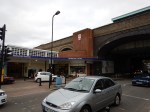
Palmers Green Station To Get A Double Upgrade
After visiting Alexandra Palace station and the Yard Cafe, I took a Hertford North train through Bowes Park and on to Palmers Green station.

The station needs refurbishment and it is getting step-free access and a branch of the Yard Cafe.
