British Gas Partners With Strata And Daikin To Launch Eco-Tech Low Bill Homes
The title of this post, is the same as that of this press release from Centrica.
This is the sub-heading.
British Gas is set to supercharge sustainable living across the UK with the launch of Low Carbon Homes – a ground-breaking pilot in partnership with Strata and heat pump manufacturer, Daikin.
These are the first four paragraphs, which fill out a bit of detail.
In anticipation of The Future Homes Standard, customers will move into new build homes which have been fitted with a full range of the latest low-carbon technology at no extra cost to the housebuilder or owner. The homes will be equipped with a 6-8 kWh Daikin air source heat pump, 4 kWh solar panels, 5 kWh battery storage, Hive electric vehicle charger and thermostat. These items will be integrated into Hive’s award-winning app, providing customers with one-stop visibility and control of their energy usage.
The first trial phase will launch at a Strata’s “Breathe” development site in Kiveton, Rotherham. As a thank you for participating in the pilot, British Gas is giving homeowners access to a fixed rate tailored British Gas tariff. Participants in the trial will also have access to a dedicated British Gas energy manager to help them optimise the technology and keep bills as low as possible, while still meeting their desired comfort levels.
Each home will be fitted with a Hive hub, which connects to the WIFI network and acts as the home’s operating system, integrating all the sustainable technology. The customers energy and heat schedules and budget will be optimised by the Hive Hub for further savings.
When the customer connects to Hive’s app they will be able to control and maximise efficiency by setting schedules and spending budgets and allowing the Hub to help them reduce their bills.
Note.
- As a Control Engineer, this to me is a good start.
- I suspect that a 6-8 kWh Daikin air source heat pump, 4 kWh solar panels and 5 kWh battery storage will keep the average house warm.
- I would expect that the three companies have optimised the ratios between the sizes of the components to give the best performance.
It is amazing to think that it was in the early seventies, that in the two sections, where I worked at ICI, engineers had just started controlling and optimising flows, pressures and temperatures in complex chemical plants.
If you’d asked any of us, when our houses heating systems would be as fully controlled, we’d have given twenty years at most.
What kept the world so long?
I have a few thoughts.
Could The Housing Have Gas For Cooking??
Yes! Centrica owns a big share with Hyundai, Kia and others of a start-up company called HiiROC.
- This is the HiiROC web site.
- HiiROC can take any hydocarbon gas and split it into green hydrogen and carbon black.
- Green hydrogen is obviously useful and the carbon black can be used for making tyres for vehicles, anodes for lithium-ion batteries and in agriculture for soil improvement.
- Waste off-gas from a chemical plant can be split into green hydrogen and carbon black.
- Biomethane from a sewage plant can be split into hydrogen and carbon black. Could a sewage plant on an estate be used to create biomethane for cooking and feeding to the HiiROC plant? Yes!
- Could green hydrogen produced on the estate be used to drive vehicles like cars, vans and ride-on-mowers. Yes! If the manufacturer of the vehicle allows it!
- How convenient would it be to have Hydrogen-at-Home?
How Much Does A British Gas Hive Save On My Energy Bill?
I asked Google and I got this answer from Home Hive.
£119. A smaller carbon footprint and a smaller bill – our award-winning smart thermostat could cut your energy bills by up to £170 a year. Join Hive Plus to boost your thermostat’s savings – and get exclusive access to £60 bill credit with any fixed British Gas dual fuel tariff.
At present, I have no intention of changing my energy supplier, but come the summer or if my health or energy circumstances change, I might see what is available.
Will British Gas Develop A Hive For a Smaller Dwelling?
I suspect in ten years, if I’m still of this world, I shall be living in the following circumstances.
- Alone.
- In a two bedroom house, cottage or flat.
- Some form of probably electric central heating or perhaps even hydrogen.
- No car.
- A short walk to the bus stop and/or train station.
- Communal gardens to sit in.
- An Ocado style delivery for food, groceries and other essentials.
- A local gluten-free cafe.
- Full Wi-Fi
Perhaps, British Gas and others will develop a community for people like me?
Tower As Tall As The Shard Approved For Square Mile
The title of this post, is the same as that of this article on the BBC.
This is the sub-heading.
A skyscraper the same height as The Shard has been approved by the City of London Corporation.
These three paragraphs add more detail.
One Undershaft, will be the tallest in the City of London, containing 74 storeys.
It will also feature a public garden on the 11th floor and a London Museum education centre.
The plans were approved by the City of London Corporation on Friday but some consultees remain opposed to the plans, including Historic England and Tower Hamlets Council.
I have read the Wikipedia entry for the Shard and feel this building could have a few problems before it is finished.
The queue opposing the building appears to be forming starting with Historic England and Tower Hamlets Council.
I also wonder, if the City of London keeps on putting up mega-scrapers like this, whether there’ll be enough men, women, machines, money and materials to build them.
And workers to fill them.
Permission Granted For Ayrshire Renewables Hub
The title of this post, is the same as that of this article on Scottish Construction Now.
This is the sub-heading.
Planning consent has been granted for a £150 million upgrade to an Ayrshire marine yard, paving the way for increased offshore wind power off the UK’s west coast.
These are the first three paragraphs.
Peel Ports Clydeport has secured permission for the complete redevelopment of the Hunterston marine yard as it prepares the site for major renewables infrastructure. The redevelopment works – which are expected to start in early 2025 and last for around two years – will include substantial upgrades to the marine yard, including infilling the current dry-dock basin and the creation of a new quay wall.
Highview Power recently announced it is to construct the world’s largest Liquid Air Energy Storage (LAES) facility at Hunterston, the latest in a string of renewables projects that are either underway, or in the pipeline, at the site.
The overall redevelopment of Hunterston is expected to attract £3.5 billion in inward investment and create over 5,000 jobs.
Note.
- The Highview Power battery will be 200 MW/3.25 GWh.
- There is also a 400 MW/400 MWh BESS being built at Hunterston.
- The 2 GW MacHairWind project is planned off the coast of Islay.
- According to their web site, MacHairWind will export its first power in the early 2030s.
More renewable infrastructure will surely follow.
UK Breakthrough Could Slash Emissions From Cement
The title of this post. is the same as that of this article on the BBC.
This is the sub-heading.
Scientists say they’ve found a way to recycle cement from demolished concrete buildings.
These five paragraphs outline, why cement is such an environmental problem.
Cement is the modern world’s most common construction material, but it is also a huge source of planet-warming gas emissions.
That is because of the chemical reactions when you heat limestone to high temperatures by burning fossil fuels.
Recycling cement would massively reduce its carbon footprint. Researchers say that if they switched to electric-powered furnaces, and used renewable energy like wind and solar rather than fossil fuels, that could mean no greenhouse gases would be released at all.
And that would be a big deal. Cement forms the foundation of the modern economy, both literally and metaphorically.
It is what binds the sand and aggregate in concrete together, and concrete is the most widely used material on the planet after water.
If cement was a country, it would be the third biggest source of emissions after China and the US, responsible for 7.5% of human-made CO2.
This article shows how by applying chemical magic to two effectively unrelated processes; the recycling of steel and the recycling of concrete to make new cement, very high rewards are possible.
Cambridge University are calling their new product electric cement.
As large amounts of electricity are used in an arc furnace, to produce the two products
These paragraphs outline the innovative Cambridge process.
Cement is made by heating limestone to up 1600 Celsius in giant kilns powered by fossil fuels.
Those emissions are just the start. The heat is used to drive carbon dioxide from the limestone, leaving a residue of cement.
Add both these sources of pollution together and it is estimated that about a tonne of carbon dioxide is produced for every tonne of cement.
The team of scientists,, has found a neat way to sidestep those emissions.
It exploits the fact that you can reactivate used cement by exposing it to high temperatures again.
The chemistry is well-established, and it has been done at scale in cement kilns.
The breakthrough is to prove it can be done by piggybacking on the heat generated by another heavy industry – steel recycling.
When you recycle steel, you add chemicals that float on the surface of the molten metal to prevent it reacting with the air and creating impurities. This is known as slag.
The Cambridge team spotted the composition of used cement is almost exactly the same as the slag used in electric arc furnaces.
They have been trialling the process at a small-scale electric arc furnace at the Materials Processing Institute in Middlesbrough.
These are my thoughts.
The Only Inputs Are Steel Scrap, Green Electricity And Used Cement
Consider.
- We probably need to increase the percentage of steel scrap we collect.
- Gigawatts of green electricity in a few years, will be available in those places like Port of Ardersier, Port Talbot, Scunthorpe and Teesside, where large amounts of steel will be needed.
- I can envisage large steel users having their own hybrid electric cement/electric arc furnace plants.
- Used cement would be collected and brought to the plants.
- Years ago, I used to live next door to an old World War II airfield. The farmer who owned the airfield, told me, that the concrete was his pension, as when he needed money, he called a company, who crushed it up for aggregate.
I can see a whole new integrated industry being created.
Conclusion
This could be one of the best inventions since sliced bread.
Redevelopment Of Scottish Port Begins As Owner Secures GBP 400 Million For Offshore Wind Upgrade
The title of this post, is the same as that of this article on offshoreWIND.biz.
This is the sub-heading.
Haventus, the owner of the Ardersier Port in the Moray Firth, Scotland, has taken a final investment decision and kicked off construction work on redeveloping the port to serve both fixed-bottom and floating offshore wind projects. The revamped port is expected to open in the second half of 2025.
These are the first two paragraphs.
This month, Haventus was granted a GBP 100 million (approximately 117 million) joint credit facility from the Scottish National Investment Bank and UK Infrastructure Bank with GBP 50 million (approx. EUR 58.5 million) investment from each.
This follows a GBP 300 million (approx. 351 million) investment commitment by the energy investment firm Quantum Capital Group in 2023 when Haventus began the redevelopment of Ardersier Port.
This page on the Haventus web site, gives more details of the Port of Ardersier.
Included are.
- Access channel width – 160 m.
- Access channel depth – 12.4 m.
- Landside area – 350 acres.
- 420m main quay.
- 80 m Ro/Ro capable berth.
- People-friendly midges
- Green Freeport tax site designation
- More space is available if required.
There is also an informative video.
Haventus say they are delivering a world-leading energy transition facility. I can go along with that!
These are my thoughts.
The Location Of The Port of Ardersier
This Google Map shows the location of the Port of Ardersier.
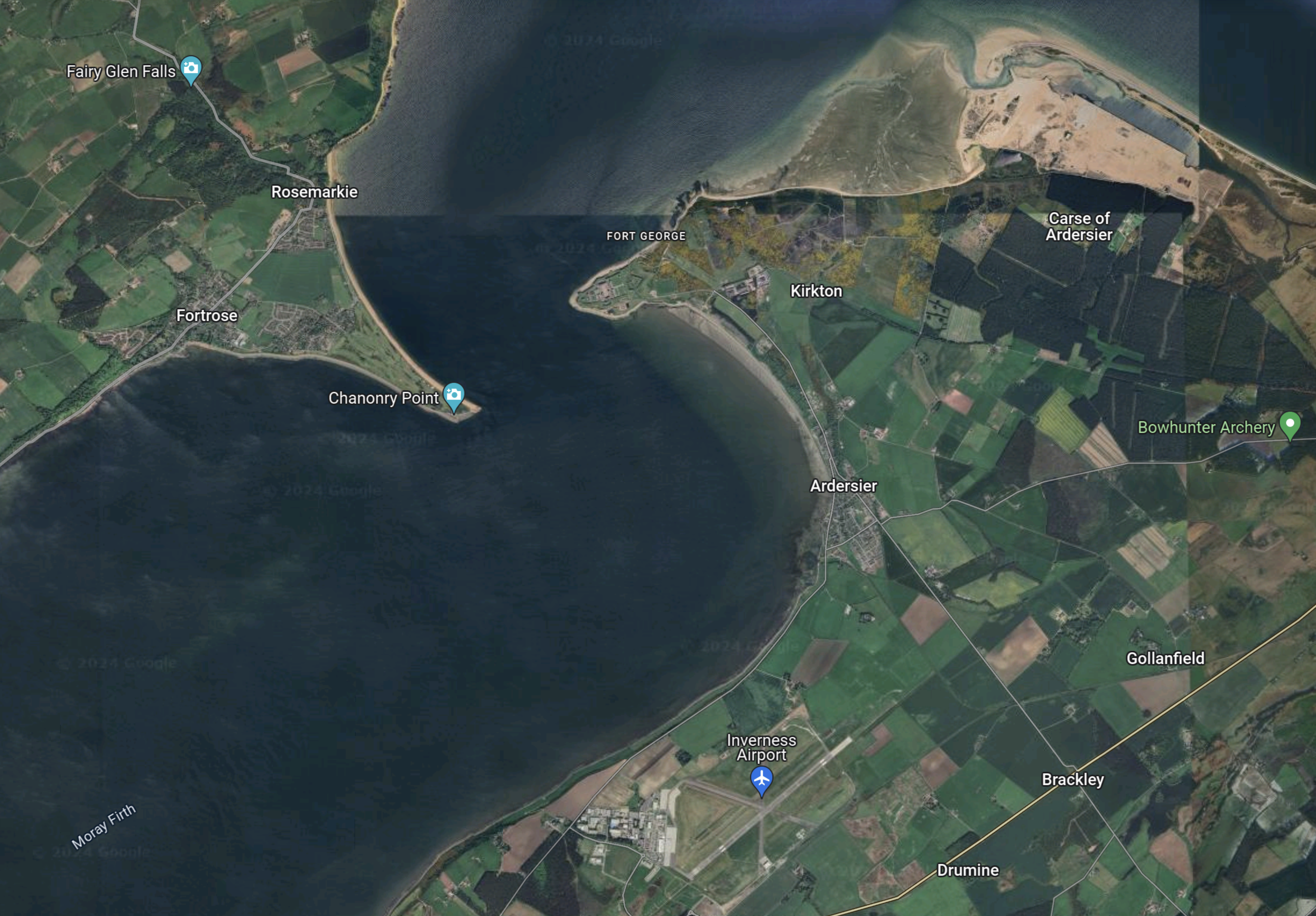
Note.
- The large expanse of water in the middle of the map is Moray Firth.
- The blue arrow at the bottom of the map indicates Inverness Airport.
- Inverness Airport, has a railway station on the Aberdeen and Inverness Line.
- The village of Ardersier is on the the Eastern bank of the Moray Firth
- The Port of Ardersier is in the North-East corner of the map.
The city of Inverness, with a population of around 48,000, is a few miles South-West of the South-West corner of the map.
Which Windfarms Will Be Built And Serviced From The Port Of Ardersier?
This map shows the various ScotWind leases, around the North of Scotland.

The numbers are Scotwind’s lease number in their documents.
These are the Scotwind wind farms to the North-East of Scotland, that could reasonably be assumed to be built and served from the Port of Ardersier.
- 7 – DEME Concessions Wind – 200 km² – 1.0 GW – Floating
- 8 – Falck Renewables Wind – 256 km² – 1.0 GW – Floating
- 9 – Ocean Winds – 429 km² – 1.0 GW – Fixed
- 10 – Falck Renewables Wind – 134 km² – 0.5 GW – Floating
- 11 – Scottish Power Renewables – 684 km² – 3.0 GW – Floating
- 12 – BayWa r.e. UK – 330 km² – 1.0 GW – Floating
These are the Scotwind wind farms to the North-West of Scotland, that could reasonably be assumed to be built and served from the Port of Ardersier.
- 13 – Offshore Wind Power – 657 km² – 2.0 GW – Fixed or Floating
- 14 – Northland Power – 390 km² – 1.5 GW – Floating
- 15 – Magnora – 103 km² – 0.5 GW – Floating
- 16 – Northland Power – 161 km² – 0.8 GW – Floating
These ten wind farms add up to 12.3 GW.
Transport
Consider.
- Obviously, heavy components will be brought in by sea, using the Ro/Ro capable berth or using a crane to unload a barge.
- Personnel will be able to fly in for the day.
- Will some visitors rom London use the Caledonian Sleeper to and from Inverness station to get a full day on site and a good night’s sleep, whilst travelling.
But I do see a problem with local traffic to and from the site.
Hydrogen Buses
This page on the Sizewell C web site, discusses how they will use hydrogen buses.
I could see the Port of Ardersier taking a leaf out of Sizewell C’s book and run hydrogen buses to Inverness, Inverness Airport and other nearby towns.
The North of Scotland certainly won’t be short of green hydrogen to power the buses.
Hydrogen
Conclusion
If you thought that the only useful wind-driven thing to come out of Scotland was bagpipes, you had better think again.
The Port of Ardersier will be the factory and operation and maintenance port for one of the largest offshore wind industries in the world.
How Hydrogen Will Power The Green Construction Eevolution
The title of this post, is the same as that of this news item from Ryze Hydrogen.
These two paragraphs introduce the news item.
According to the International Energy Agency buildings operations and construction emissions account for more than one-third of global energy-related emissions, significantly contributing to environmental degradation, with heavy machinery and standby power solutions relying heavily on fossil fuels.
Yet here at Ryze we know the industry stands on the brink of a green revolution, as clean energy solutions lead the charge towards decarbonisation.
The news item, is a must-read for anybody involved in construction.
Recently, a gas leak killed the roadside tree outside my house. I wrote about the incident in It Looks Like The Gas Leak Has Killed The Tree Outside My House.
What I didn’t say, was that when they cleaned up the mess, I had an eight-wheeled diesel truck with a grab, working outside my house for a couple of hours, spewing fumes everywhere.
Hopefully, green construction is friendlier to the neighbours and the workers on site.
High Speed Two is using green construction for this reason in sensitive locations.
Waterbeach Station To Be Relocated
The title of this post, is the same as that of this article on Railway Gazette.
These three paragraphs, outline the project.
Cambridgeshire County Council has called tenders for an estimated £35m design and build contract for the relocation of Waterbeach station to a new site further to the north.
This would support the Waterbeach New Town development of 4 500 homes. Opening is now envisaged for 2026.
The replacement station would have two platforms, an accessible footbridge, a 200-space car park, taxi and bus drop-off, cycle storage and a new access road from Cody Road. The 24-month scheme would include the demolition of the existing station.
This Google Map shows the current station and the location of Waterbeach New Town.
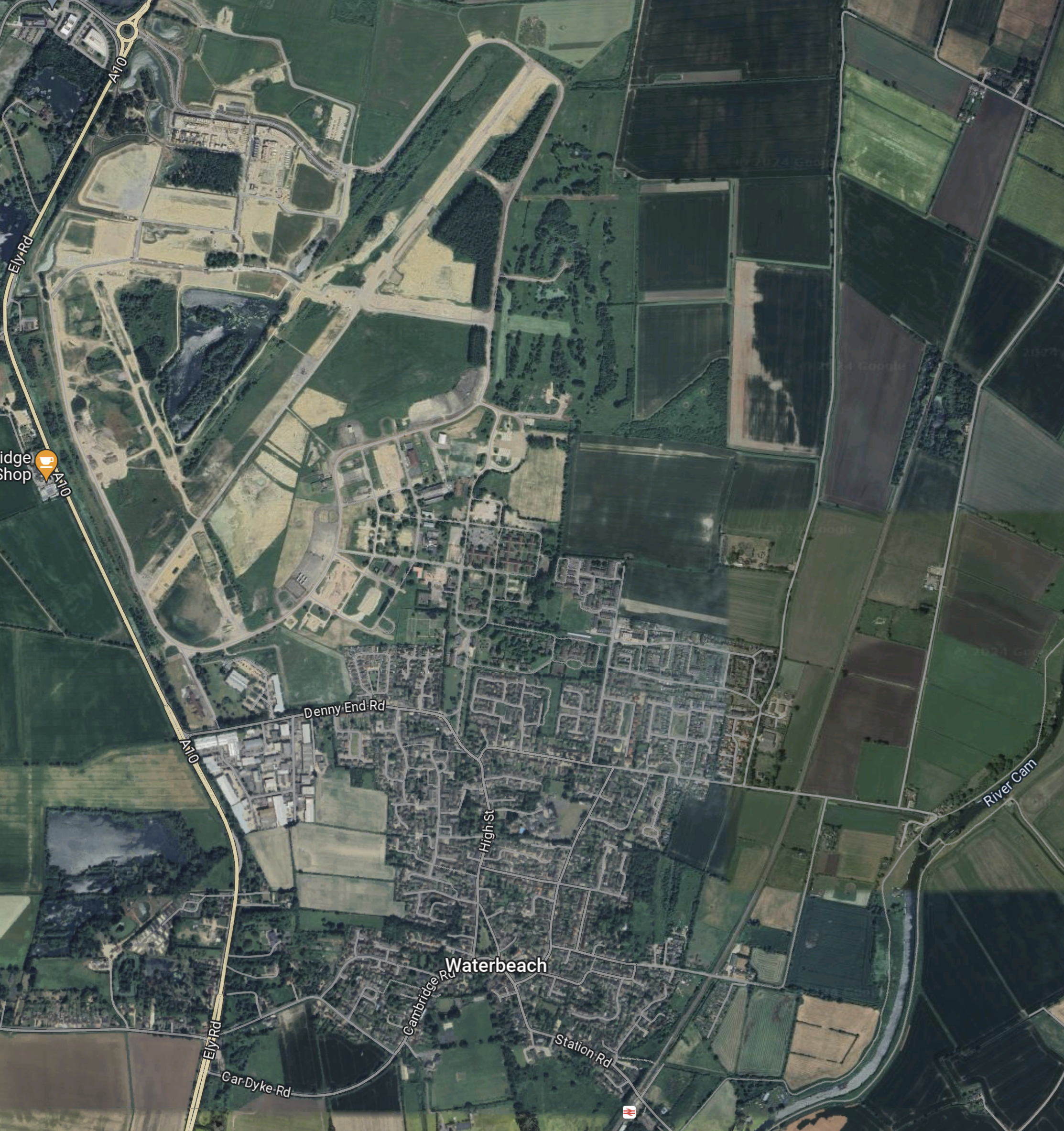
Note.
Waterbeach station is at the bottom of the map, just to the right of centre.
- The station is on the Breckland Line between Cambridge and Norwich via Ely.
- The Breckland Line continues North-East to the North-East corner of the map.
- The village of Waterbeach is to the North of the station.
- North of Waterbeach is the old Waterbeach Airfield, which will be covered in the housing of the New Town.
Moving the station nearer the New Town would seem to be a sensible action.
I have some further thoughts.
The Remodelling Of Ely
Ely station is a railway bottleneck and in Are The Trains In Ely Finally To Be Sorted?, I discussed what needed to be done.
Would it help, if Waterbeach station were to be rebuilt first?
A Cambridge Metro
Once Waterbeach station has been rebuilt and Cambridge South station has been built, there will be a run of stations through Cambridge.
- Ely
- Waterbeach
- Cambridge North
- Cambridge
- Cambridge South
Perhaps, extra trains could be added to create a frequent rail route across Cambridge.
East West Railway
Will the trains of the East West Railway stop at Waterbeach station?
Conclusion
Waterbeach could be a very useful and busy station.
Sizewell C – South Park And Ride
This document on the Planning Inspectorate web site, is a description of the Southern Park and Ride for the Sizewell C Project.
This Google Map shows the area of the Park-and-Ride site.
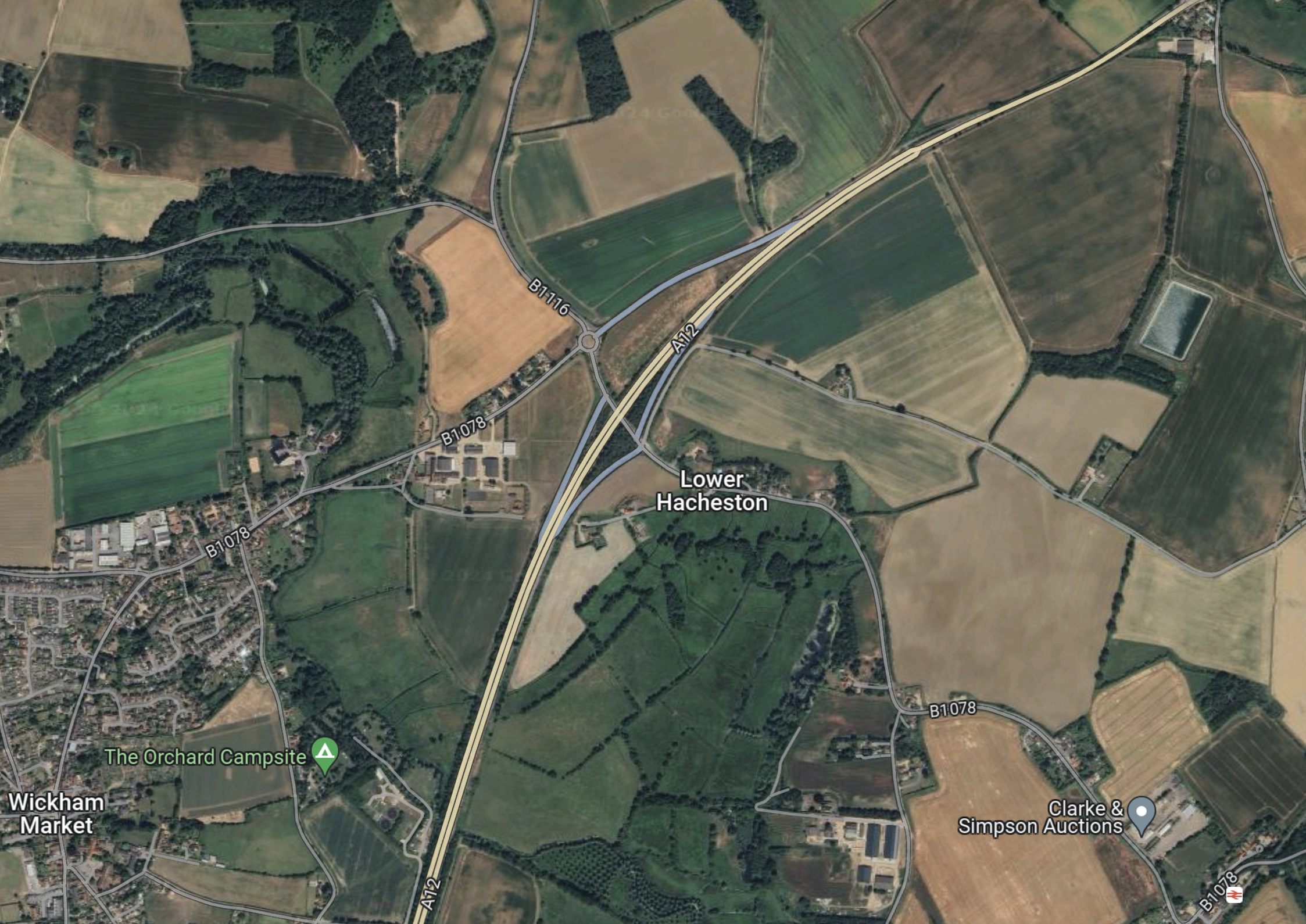
Note.
- Wickham Market is in the South-West corner of the map.
- The dual-carriageway is the Wickham Markey by-pass, which is part of the A12 between Ipswich and Lowestoft.
- Close to Lower Hacheston is the Northern junction of the by-pass which connects the B1116 and B 1078 roads to the A 12.
- If my memory serves me correctly, there is a small roundabout to the North of the A12, where the B 1116 and B 1078 cross, which is referred to as Fiveways Roundabout in some of the documentation.
- Wickham Market station is in the South-East corner of the map.
I know the area well, as I used to live less than ten miles to the West of Fiveways roundabout.
This shows the area to the North of Fiveways roundabout to a large scale.
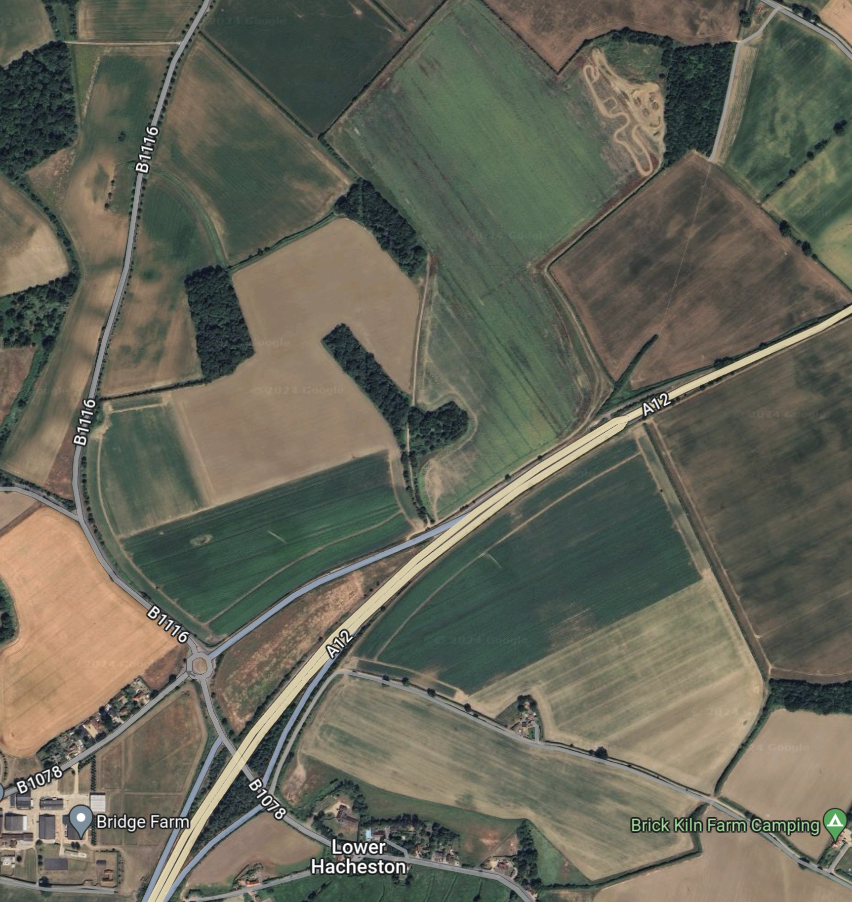
The document on the Planning Inspectorate says this about the site.
The site comprises approximately 26.4 hectares (ha) of predominantly
agricultural land and highway land located north-east of Wickham Market.
The part of the site which would contain the parking and buildings, postal
consolidation building and Traffic Incident Management Area (TIMA) is
approximately 18ha in size, and located to the east of the B1078/B1116, to
the north of the A12. The remainder of the site encompasses a section of
the A12, and an associated slip road where highway improvements are
proposed to form the site access, and associated signage and road
markings, see Chapter 1, Figure 1.1 of this volume.
These are my thoughts.
There Is No Rail Connection
I wrote about the Northern Park-and-Ride in Sizewell C – North Park And Ride and there is one big difference.
The Northern Park-and-Ride is an easy walk from Darsham station.
- Darsham station has an hourly four-car train to Lowestoft and Ipswich.
- Some or all trains could be doubled in capacity as Greater Anglia has enough stock to do this.
- If required, trains could be run to and from London and intermediate stations.
- In the past, Network Rail have developed plans to extend the service as far as Yarmouth.
I believe that a rail connection at the Southern Park-and-Ride could have added flexibility for workers in Ipswich travelling to the Sizewell site.
Bus Routes
The frequency and timing of park and ride buses would depend on the
working patterns adopted during construction of the Sizewell C main
development site, and the number of workers to be moved during the shift
changeover periods. More frequent services would operate during staff
changeover and shift start/end periods. It is anticipated that there would be
three to nine buses from the proposed development per hour during shift
changeover period, and an hourly service outside shift changeover periods.There would be a maximum of 100 daily bus arrivals and 100 daily bus
departures from the proposed development to the Sizewell C main
development site. These buses would use the A12, two village bypass and
Sizewell link road once operational to travel to and from the Sizewell C main development site.
This Google Map shows the A 12 between the South Park-and-Ride site and Yoxford.
Note.
- Yoxford is in the North-East corner of the map.
- Wickham Market is in the South-West corner of the map.
- The A 12 is the cream road linking the two villages.
- The Southern Park-and-Ride will be to the North-East of Wickham Market.
- The Northern Park-and-Ride is a couple of miles North of Yoxford.
- Yoxford and Wickham Market are 11.8 miles apart.
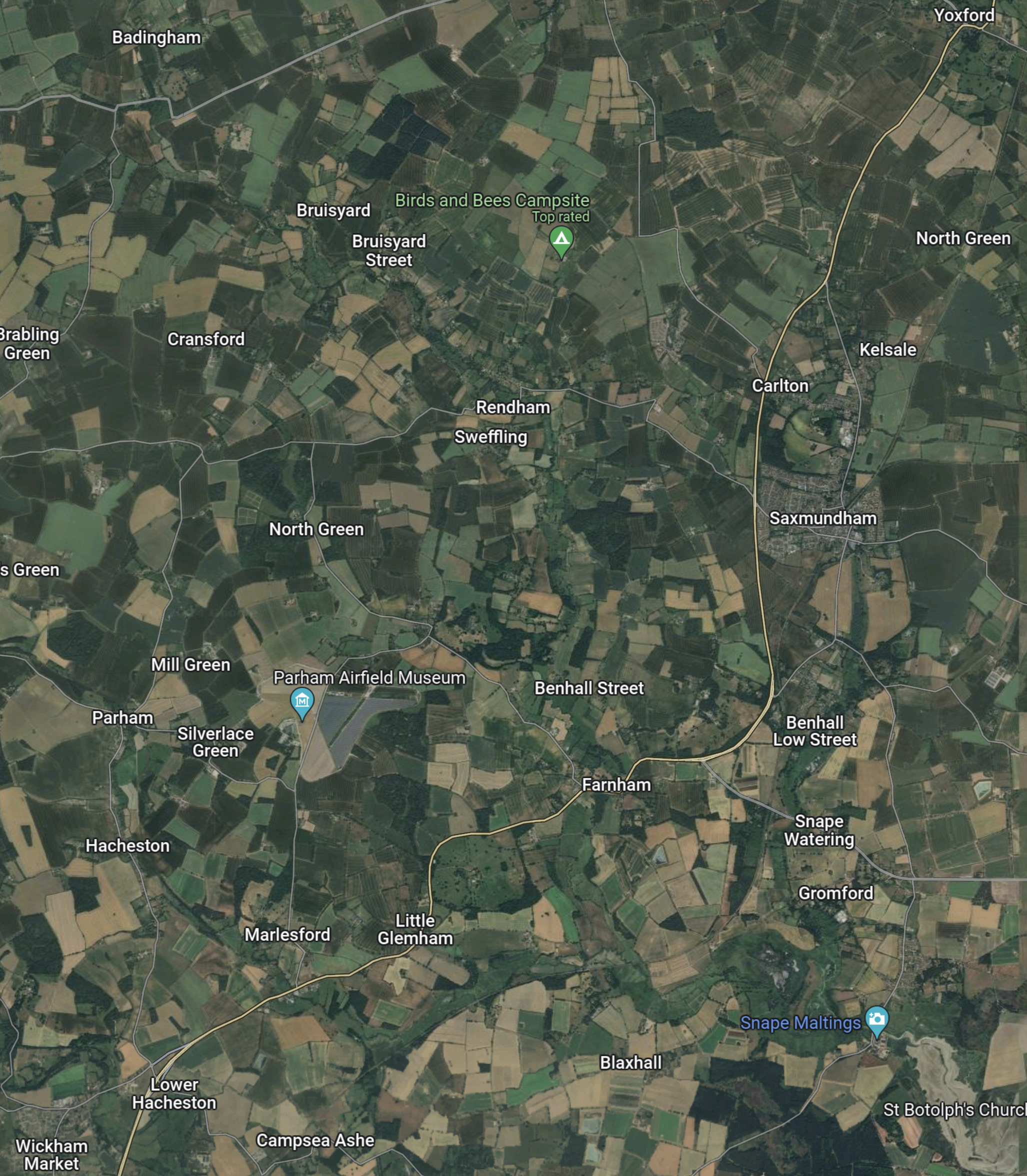
This third Google Map shows the route between Yoxford and Sizewell.
Note.
- Yoxford is in the North-West corner of the map.
- Sizewell is in the South-East corner of the map.
- Leiston Abbey is indicated by the arrow to the North of Leiston.
The B 1122 can be picked out through Middleton Moor and Theberton and then as it skirts Leiston Abbey.
It appears that both Park-and-Ride sites, use the same connection between the A 12 and Sizewell C.
Objections To The Park-and-Ride
This petition on change.org is entitled Stop Sizewell C Park and Ride at Wickham Market.
The petitioner is objecting on the following grounds.
- The size of the site.
- Spoiling of views.
- Disturbance to walkers and horse riders.
- Terrestrial ecology and ornithology will be affected by the site.
- Increase in traffic.
This was the petitioner’s conclusion.
In conclusion I oppose the Sizewell C southern park and ride site at Wickham Market and believe it should be sited further south on the A12 away from residential areas and near the A14.
The Ipswich Northern By-Pass
There is another large project scheduled for Ipswich in the next few years; the Ipswich Northern By-Pass.
This map clipped from the Ipswich Borough Council web site shows possible routes.

Note.
- Wickham Market is in the North-East corner of the map.
- One of the aims of the Northern by-pass is to open up land for housing.
- The railway between Ipswich and Darsham stations goes via Westerfield, Wiidbridge, Melton andWickham Market.
- Perhaps by phasing the developments, an area could be used for a Park-and-Ride, which has a road connection to the A 12.
- When the need for Park-and-Ride for Sizewell has decreased, the site could be handed over to housing.
It would certainly help, if the route of the Northern by-pass was settled soon.
Sizewell C – Where Will The Workers Live?
I have now written about, where the two Park-and-Ride sites are to be built.
- The Northern Park-and-Ride is proposed for Darsham.
- The Southern Park-and-Ride is proposed for Wickham Market.
I can now write about where the workers could be billeted.
I suspect there could be a Bibby Stockholm solution, where accommodation barges are used.
This Google Map shows the centre of Ipswich.
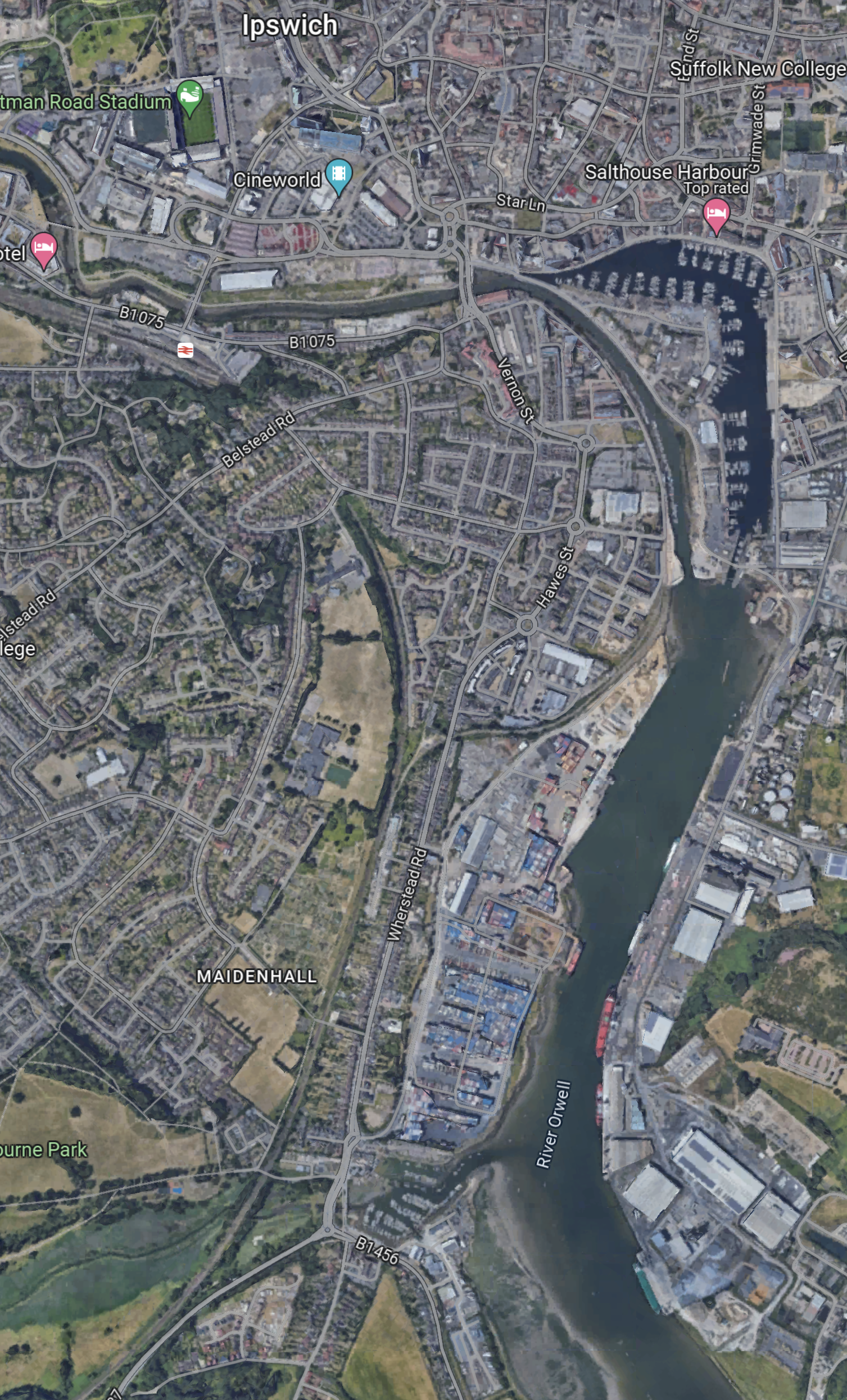
Note.
- There is a lot of space on the River Orwell.
- Ipswich station is in the North-West corner of the map.
- There could be a shuttle bus between the barge and the station.
- Trains could take workers to Darsham for buses to Sizewell.
There could even be direct buses to Sizewell.
This Google Map shows the centre of Lowestoft.
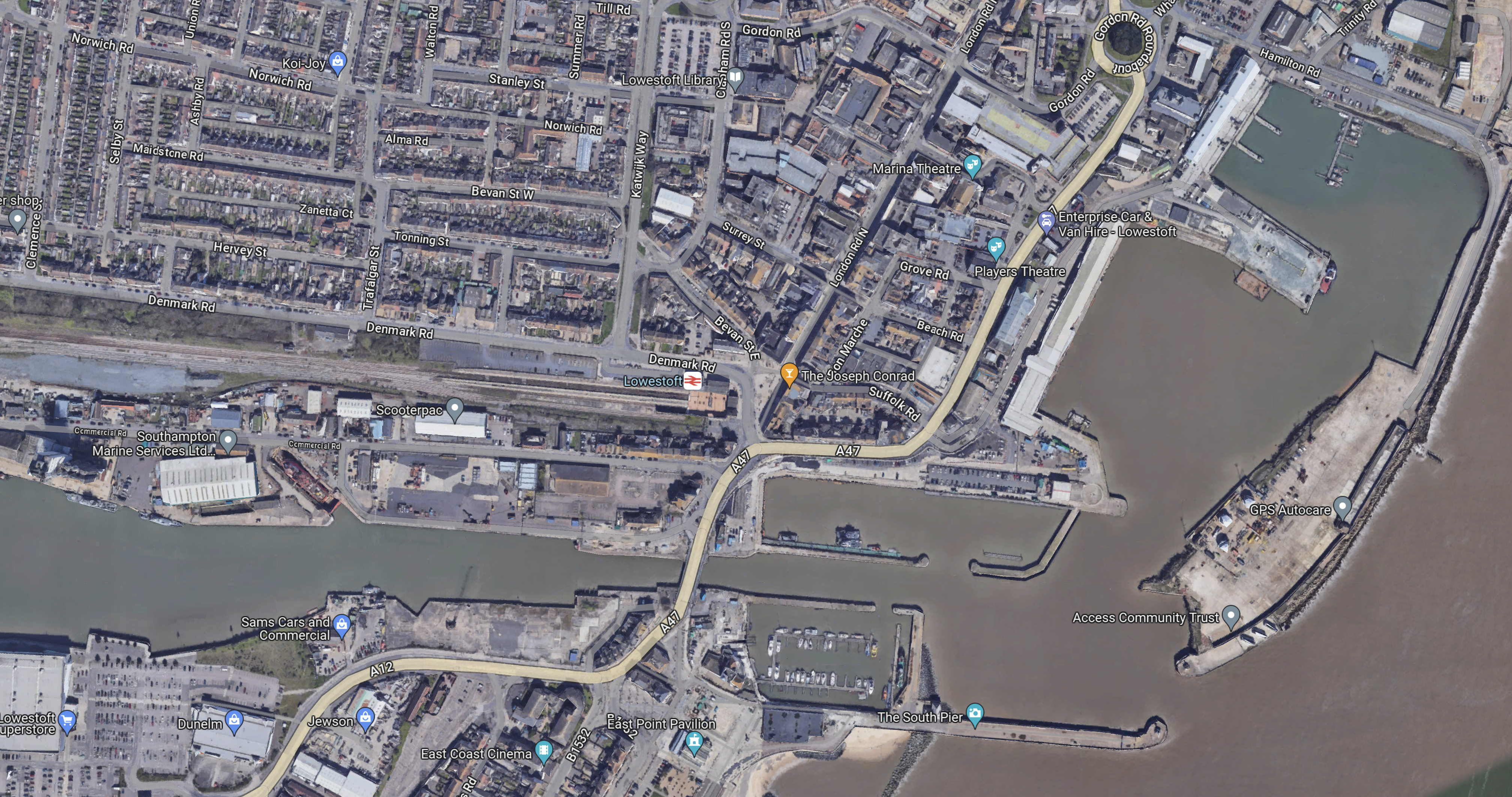
Note.
- The Bibby Stockholm is 100 metres long with a beam of 30 metres.
- Lowestoft station is close to the port.
Workers could take the train direct to the Northern Park-and-Ride for Sizewell C.
Sizewell C – North Park And Ride
This document on the Planning Inspectorate web site, is a description of the Northern Park-and-Ride for the Sizewell C Project.
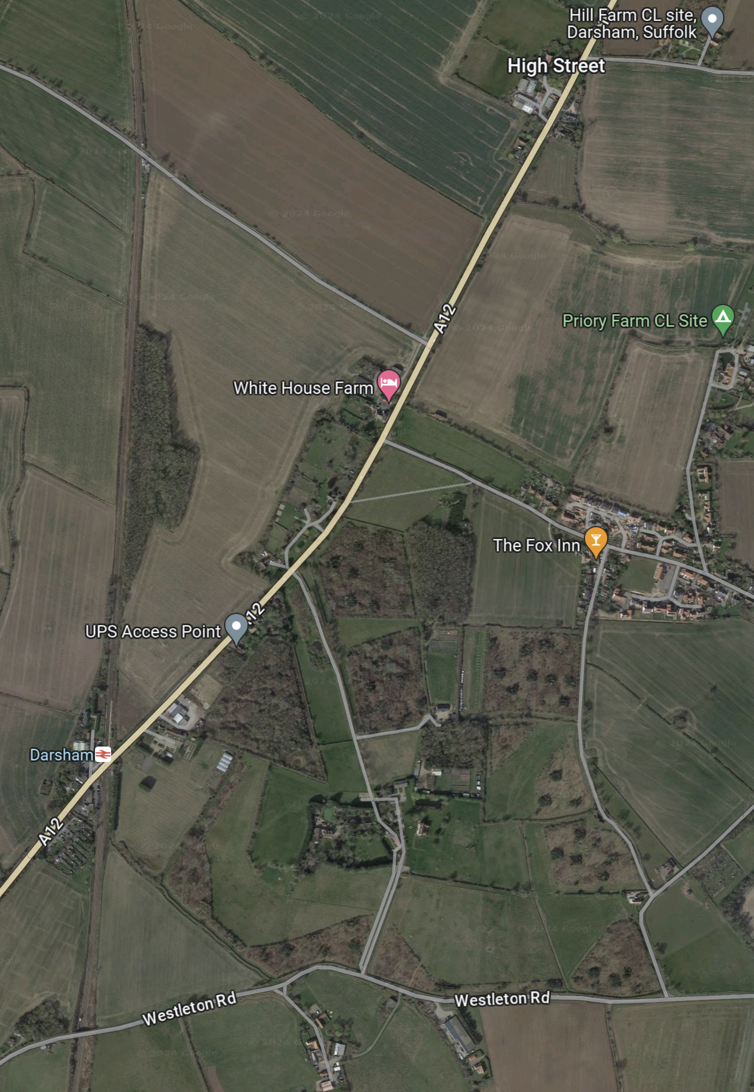
This Google Map shows the area of the Park-and-Ride site.
Note.
- The main road running SW-NE is the A 12 between Ipswich, Felixstowe and Woodbridge in the South and Lowestoft and Great Yarmouth in the North.
- The East Suffolk Line runs North-South at the West side of the map.
- Darsham station, which is indicated by the red logo on a white background is situated, where road and railway cross.
- The Fox Inn is in the village of Darsham and indicated by an orange arrow.
- The pink arrow to the North-West of the Fox Inn indicates White House Farm.
- The lane going North-West from the A 12 to the North of the farm is Willow Marsh Lane.
The document on the Planning Inspectorate says this about the site.
The site comprises approximately 27.9 hectares (ha) of predominantly
agricultural land but also includes sections of the A12 and Willow Marsh Lane
towards the north of the site. It is located west of the village of Darsham and
west of the A12, to the east of the East Suffolk line, and to the north of
Darsham railway station (see Chapter 1, Figure 1.1 of this volume). Further
detail on the site and the environmental baseline is provided in Chapters 1
and 4 to 12 of this volume of the Environmental Statement.
This second Google Map shows Darsham station.
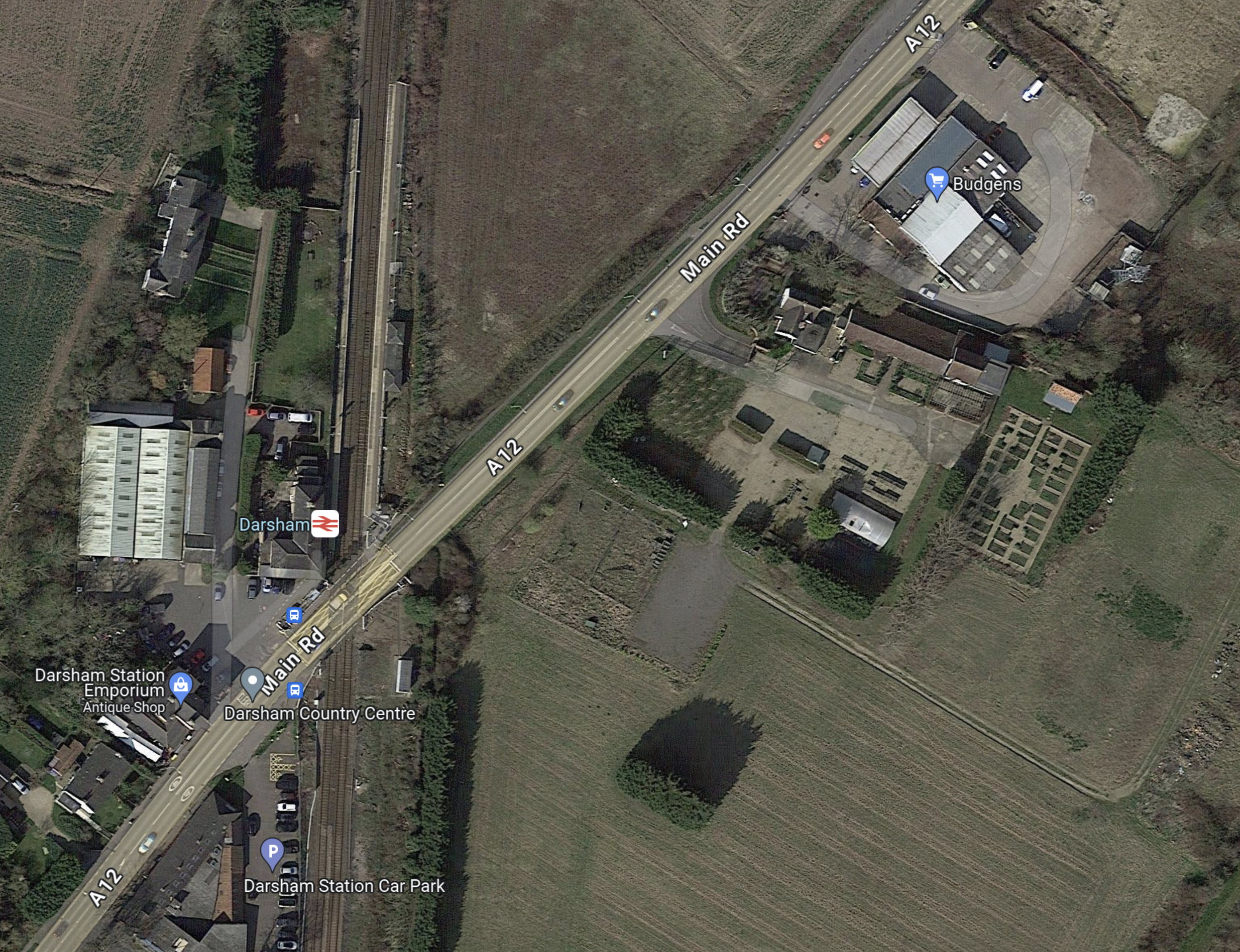
Note.
- Darsham station has long platforms.
- Crossing the line is by means of the level crossing.
- The Budgens store, which is indicated by the blue arrow also sells fuel.
- The station has a bus service.
- The Southern end of the Park-and-Ride site lies between the railway and the road at the North of the map.
The document on the Planning Inspectorate says this about walking between the Park-and-Ride site and the station.
There would be a pedestrian route from Darsham railway station along the
footway on the A12 to the south-east of the site. Pedestrians accessing the
site would leave the A12 and enter through a security gate provided in the
security fencing. Further details of access measures (such as key fobs,
CCTV, intercom system) would be agreed at the detailed design stage.
I could probably manage that at 76.
These are further thoughts.
The Current Rail Service
Currently, the rail service is as follows.
- One train per hour (tph) in both directions.
- |Trains are Class 755 trains, built by Stadler in Switzerland a few years ago.
- Each train can carry up to 229 passengers.
- Up to three trains can run together.
- Trains going to and from Lowestoft in the North call at Oulton Broad South, Beccles, Brampton and Halesworth.
- Trains going to and from Ipswich in the South call at Saxmundham, Wickham Market, Melton and Woodbridge.
- Travellers for London Liverpool Street change at Ipswich.
- The first train from London Liverpool Street would get you to Darsham at 11:00.
- This is not a bad train service but it could be improved.
Direct Trains Between London Liverpool Street And Lowestoft
In 2016, I wrote Making Sense Of The New East Anglia Franchise.
I wrote the following about Greater Anglia’s plans to run four trains per day between London Liverpool Street and Lowestoft.
There are going to be four direct services between London and Lowestoft each day. This probably initially means two trains to London in the morning peak and two trains back in the evening one.
When, I first moved back to Suffolk in the 1970s, I regularly caught a diesel-hauled train from Wickham Market to London for the day.
This is all motherhood and apple pie for those in Lowestoft wanting to go to London, but I suspect it isn’t the easiest service for a train operator to schedule efficiently and make money.
Would a train operator really want to start a full train at Lowestoft at say six in the morning and then have it wait around all day in London before returning in the evening?
The East Suffolk Line from Ipswich to Lowestoft has the following characteristics.
- It is fifty miles long.
- It is not electrified.
- It has a speed limit of 40-55 mph.
- There are nine intermediate stations. Many are just a single platform, and car parking is fairly limited.
- It has enough double-track and a passing loop at Beccles station to run a train in both directions at the same time.
- As it ran long trains in the past, I suspect, that most of the stations have platforms that can handle at least six-carriage trains.
- Trains would appear to take around ninety minutes for the whole journey
But the most important characteristic, is that every time the line is improved, more passengers come rushing out of the woodwork.
There would certainly be no problem with running bi-mode Flirts on this route, as London-Lowestoft is just the type of route for which they are designed.
- They would use their on-board diesel engines on the East Suffolk Line.
- As some would work along the busy lines to London, I suspect their top speed under electric power would be the same as the EMUs.
- Services to and from London, once on the Great Eastern Main Line, would join the high-speed race to and from the capital.
- At the start and finish of the day, the trains could use the electrified main line to position between Ipswich and Crown Point depot at around 100 mph.
- Abellio could use either a single three- or four-car train or perhaps two trains coupled together.
This service would pass through Darsham station, so it could provide a direct link between London and the Park-and-Ride.
It might also stop at stations like Manningtree, Colchester, Chelmsford and Stratford.
I am fairly certain, that a London Liverpool Street and Lowestoft services, that stopped at Darsham station, would improve labour availability and construction efficiency at Sizewell C.
A Connection To Yarmouth
There used to be a direct Yarmouth to Lowestoft Line, but now it is possible to use the Wherry Lines, with a reverse at Reedham station.
So will we be seeing the direct London-Lowestoft trains being extended to Yarmouth?
As Yarmouth hasn’t had a direct connection to London for years and there are lots of fast, capable new trains, I wouldn’t be surprised.
Especially, as Network Rail are talking about reinstating the Reedham Chord to create a more direct route between East Anglia’s largest North-Eastern towns. This is said about the Reedham Chord in Direct Yarmouth Services in the Wikipedia entry for Lowestoft station.
In January 2015, a Network Rail study proposed the reintroduction of direct services between Lowestoft and Yarmouth by reinstating a spur at Reedham. Services could once again travel between two East Coast towns, with an estimated journey time of 33 minutes, via a reconstructed 34-chain (680 m) north-to-south arm of the former triangular junction at Reedham, which had been removed in c. 1880. The plans also involve relocating Reedham station nearer the junction, an idea which attracted criticism.
If we take these current approximate timings.
- Ipswich to Lowestoft takes 90 minutes.
- Lowestoft to Reedham takes 27 minutes.
- Reedham to Yarmouth takes 16 minutes.
That means the service today would take 133 minutes, with a train reverse at Reedham station.
Note.
- Modern three-car bi-mode Flirt trains, with better speed, acceleration and braking than the current Class 170 trains.
- The short-cut along the Reedham Chord, which could save as much as ten minutes.
- A few selective improvements to save a minute here and there.
- Lowestoft station is redeveloped forty metres to the West and eighty metres to the South, as detailed in Wikipedia under Relocation Of The Station.
- I think it would be possible for an Ipswich-Yarmouth service to do the trip in around two hours.
The service would have the following characteristics.
- It would be timetabled for under the all-important two hours.
- Trains would turnround efficiently in a few minutes at either end of the line.
- It could be hourly with four trains or two-hourly with just two, used to run the service.
- All stops would be at the same minutes past each hour at each station.
- Trains would always leave Ipswich and Yarmouth at the same number of minutes past the hour.
- Lowestoft and Yarmouth get a regular hourly direct train service in just thirty-three minutes.
- Intriguingly if the trains left Ipswich and Yarmouth at the same time, they would pass each other at Beccles station, which incorporates a passing loop.
- As Beccles and its passing loop, fits so well into this schedule, I suspect that it was designed with the Reedham Chord and this type of service in mind.
- There would be no prizes for guessing the beer, that should be served on a train on this route.
I don’t think any better than an hourly service, could be run, without some extra passing loops or double-track.
This extension would make commuting between Sizewell and Yarmouth easier.
Bus Route Between Darsham And Sizewell
The document on the Planning Inspectorate says this about the buses and the route.
There would be a maximum of 100 daily bus arrivals and 100 daily bus
departures from the proposed development to the Sizewell C main
development site.Bus services between the proposed development and the Sizewell C main
development site would travel south on the A12 and use the new A12/B1122
roundabout (Yoxford Roundabout – see Volume 7 of the ES) to access the
B1122 and the Sizewell link road (once operational – see Volume 6 of the
ES) towards the Sizewell C main development site.
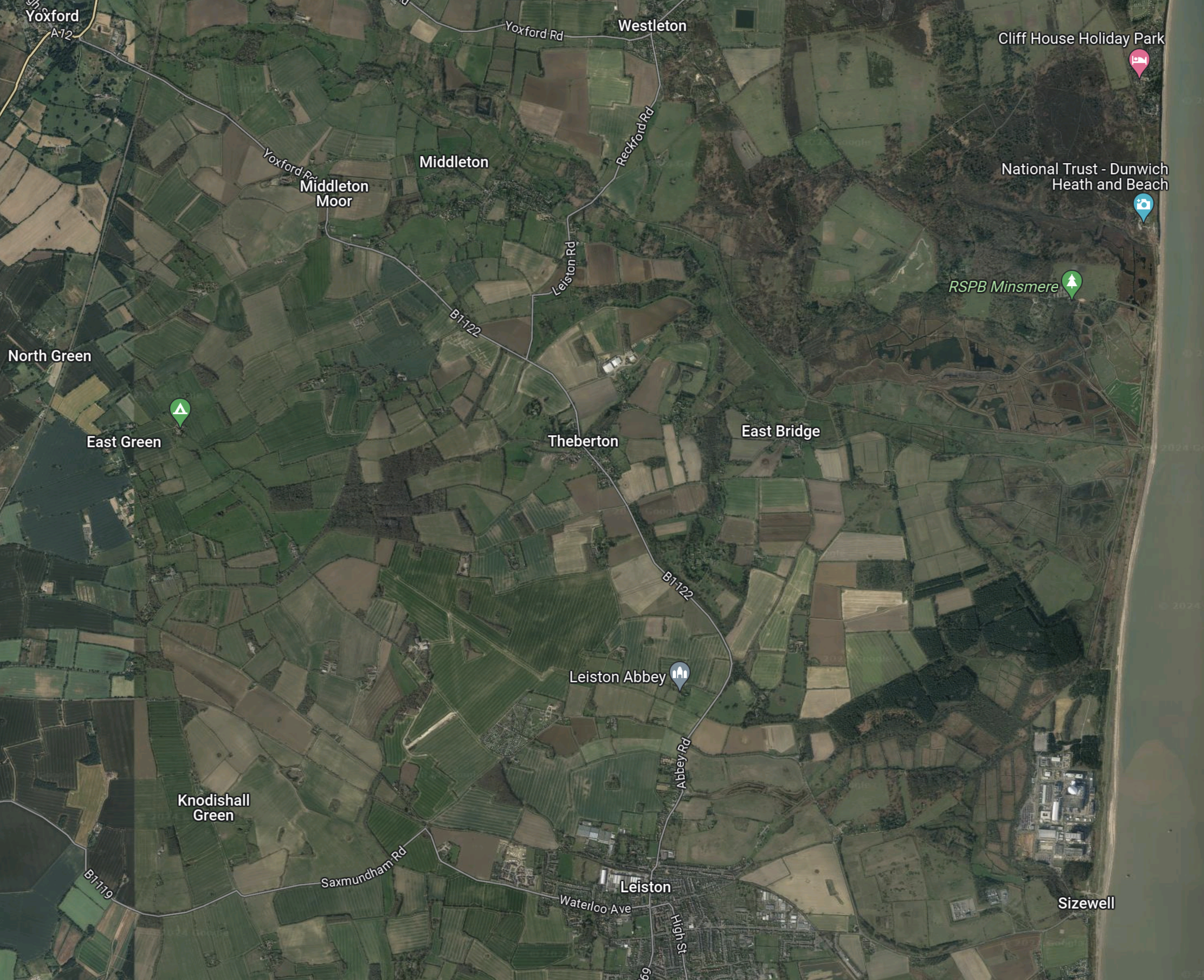
This Google Map shows Darsham station and the Sizewell site, as it exists today.
Note.
- The Sizewell site is in the South-East corner of the map.
- Darsham station is in the North-West corner of the map.
This second Google Map shows the A 12 between Darsham station and Yoxford.

Note.
- Darsham station is at the top of the map on the A 12.
- The village of Yoxford is on an S-bend of the A 12.
- A B& B is marked by a pink arrow.
The B 1122 connects Yoxford to the South-East corner of the map.
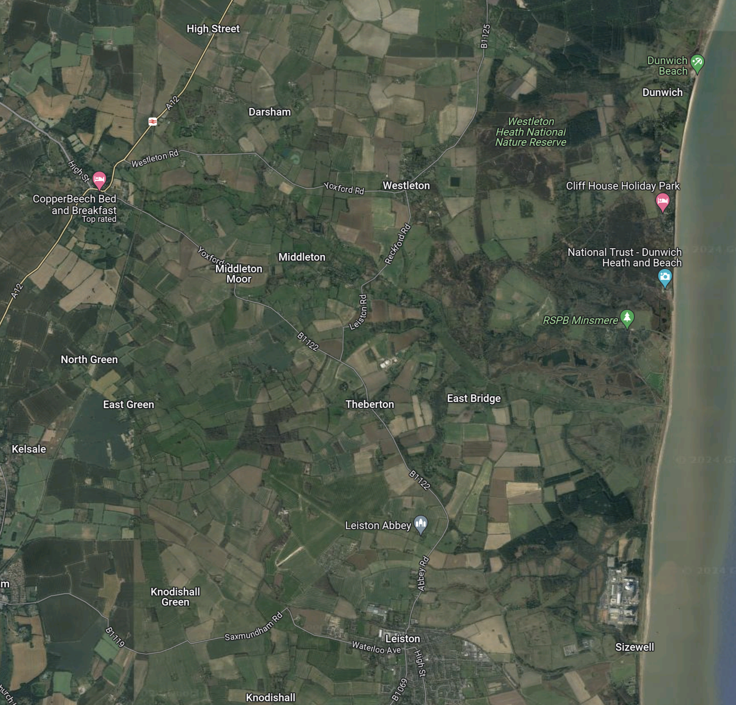
This third Google Map shows the route between Yoxford and Sizewell.
Note.
- Yoxford is in the North-West corner of the map.
- Sizewell is in the South-East corner of the map.
- Leiston Abbey is indicated by the arrow to the North of Leiston.
The B 1122 can be picked out through Middleton Moor and Theberton and then as it skirts Leiston Abbey.
Sizewell C seem to have made a good effort to get the workers to the site.
Why Isn’t A Passenger Train Run Between Ipswich And The Sizewell Site?
In Network Rail Prepares To Send Four Trains A Night Through Suffolk To Sizewell, I came to this conclusion.
I am fairly certain, that it is possible to move four freight trains in and out of the Sizewell site during the night, without doing any major works to the East Suffolk Line between Ipswich and Saxmundham junction.
- Adding extra track at Wickham Market would probably cause major disruption.
- Some level crossings will probably be improved.
But without a full double track between Ipswich and Saxmundham junction, I doubt there could be any increase in passenger services.
But with those track works, it might be possible to run an hourly service between Ipswich and Aldeburgh with calls at Westerfield, Woodbridge, Wickham Market, Saxmundham, Sizewell and Leiston.
This would give a two tph service between Saxmundham and Ipswich.
Objections To The Park-and-Ride
This document from Darsham Parish Council is entitled Consultation Response To Sizewell C.
This is the first paragraph.
Darsham Parish Council (Darsham PC) continues to oppose the proposed location of the Northern Park and Ride (NPR). We believe its location on an already busy single carriageway section of the A12 just north of the level crossing at Darsham Station, coupled with proposed roundabouts at Willow Marsh Lane and the A1120 junction in Yoxford are a recipe for traffic chaos extending northwards up the A12. We have no confidence in the traffic estimates submitted by EDF, which we believe underestimate the amount of local, through, agricultural and tourist traffic. This will be exacerbated by the proposed motel and further proposed development south of the station. We believe that traffic congestion on this main artery into Suffolk will adversely impact tourism throughout the AONB, which generates more than £360 million pa to the local economy (2018 figure). Further, we believe these volumes of traffic will generate excessive noise, vibration and pollution with serious negative impacts on those living alongside or close to the A12. Most significantly, Darsham PC has been advised that location of the NPR on this site could pose a significant flood risk to the railway (see below).
The Parish Council is also worried about flood risk to the railway.
The site of the NPR slopes down from Willow Marsh Lane towards the railway. A consulting engineer has advised us that the heavy clay soil here could pose a drainage and flood risk problem when compacted during the construction period. An appropriate sustainable semi-permeable surface could be utilised for car parking spaces to reduce run-off, with suitable drainage and reservoir capacity at the southern end to protect the railway from flooding. We submitted this evidence to EDF during the consultation period, but it has been ignored.
I suspect as with the opposition to Sizewell B, the opposition is led by second home owners, worried about the value of their investment.
