Mega Airport Costing £24billion In Europe To Rival Heathrow And Dubai
The title of this post is the same as that of this article in the Daily Express.
A new mega airport is being built in Europe, and it is set to rival the likes of Dubai and London Heathrow in terms of size and capacity for passengers and planes alike
These three paragraphs add more details.
A plush new airport could be touching down in Europe, set to rival London’s Heathrow and even the esteemed Dubai International, as it aims to link the entire continent in unprecedented ways.
The Centralny Port Komunikacyjny, a proposed $32.5 billion project, is a fresh aviation gateway in Warsaw that carries the burden of Poland’s ambitious mega airport aspirations. However, the concept is swiftly progressing, with the official approval and handover of the passenger terminal design marking a significant leap forward.
This suggests the colossal airport is officially moving into its next phase of development. The question remains, will this new progression challenge the supremacy of the Middle East, home to both the world’s largest airport, King Fahd International Airport in Saudi Arabia, and the busiest, Dubai International Airport?
Note.
- In English, Centralny Port Komunikacyjny means Central Communications Port.
- CPK’s forecasted passenger capacity makes it a formidable contender as the new hub for Europe.
- Dubai is on course to handle 100 million passengers by the end of next year, thanks to its strategic geographical position with other continents, while the Polish project will eventually accommodate up to 44 million.
- n 2024, Heathrow Airport welcomed a record 83.9 million passengers, a 6% increase from the previous year.
Even the busiest airports in Europe handle far fewer passengers than Dubai.
Central Communications Port has a Wikipedia entry, which has this first paragraph.
The Central Transport Hub is a planned major infrastructure project in Poland aimed at the construction of a new international airport and the development of a nationwide integrated transport network. The airport is planned to be located approximately 40 kilometres (25 mi) southwest of Warsaw, connected to a new high-speed rail network and controlled-access highway system linking it with much of the rest of the country.
Note.
- The airport will be designed by Foster + Partners in collaboration with Buro Happold.
- Initially the airport is planned to have two runways, but will eventually be expanded to four.
- The combined airport and railway station is planned to serve 40 million passengers per year, double the size of Berlin Brandenburg Airport.
- The long-term goal is about 100 million passengers per year.
These are my thoughts.
The Airport’s Location
The Wikipedia entry for the airport has a section called Location, which has this first paragraph.
The airport’s planned site is about 40 km west of Warsaw, next to the village Stanisławów which is part of Gmina Baranów in Grodzisk Mazowiecki County. The Baranow commune occupies a significant part of the Grodzisk County and, despite its rural character, has an extensive road infrastructure. The A2 autostrada and railway lines run in the immediate vicinity of the potential construction site, and Wrocław (Expressway S8) and Poznań (National road 92) is nearby.
It sounds to me, that a British equivalent airport, would be a four-runway airport at Birmingham Airport with connections to the M1, M6, HS2 and the West Coast Main Line.
Rail Connections
The Wikipedia entry says this about rail connections.
Planned train connections from the CPK will take 15 minutes to Warsaw Central railway station, 25 minutes to Łódź Fabryczna railway station, and 2 hours to most other major Polish cities, such as Kraków, Wrocław, Poznań and Gdańsk. The construction of a high-speed train to Frankfurt (Oder) is also planned, which is to shorten the travel time on the Berlin-CPK route to under 3.5 hours
I suspect that Rail Baltica’s trains between Berlin and Helsinki via Warsaw, Kaunus, Riga, Bialystok and Tallinn will also stop at the airport.
The Airport Will Become A Gateway To North-East Europe
I wouldn’t be surprised to see Central Communications Port become a low-cost gateway to the surrounding countries., like Belarus, Estonia, Finland, Latvia, Lithuania and hopefully Ukraine.
Polish Hospitality
Consider.
- Most Poles speak English better, than what I does!
- There are several large Polish cities that are worth a visit.
- The food is excellent, as the local basic ingredients are of high quality.
- I have spent about a month in Poland and I’ve stayed in all levels of accommodation from the lowest to the highest and have never felt need to complain.
- They handle my gluten-free diet with no problem.
My experience of Belarus was also similar.
Could Wrightbus’s New Hydrogen Coach Do A London Scotland Round Trip On A Full Load Of Hydrogen?
Victoria Coach Station And Edinburgh
I have just looked up on the National Express web site and found that I can leave Victoria Coach Station at 22:00 and arrive in Edinburgh at 07:40 the following morning for a ticket price of £29.90.
The road distance would appear to be 638.1 km, which would be a 1276 km round trip. So I would expect that, there would need to be refueling in the round trip.
Victoria Coach Station And Glasgow
I have just looked up on the National Express web site and found that I can leave Victoria Coach Station at 23:00 and arrive in Glasgow at 07:40 the following morning for a ticket price of £23.90.
The road distance would appear to be 652.1 km, which would be a 1300 km round trip. So as with Edinburgh, I would expect that, there would need to be refueling in the round trip.
A Refuelling Strategy
Consider.
- I would expect that a refuelling strategy would minimise, the carrying of large amounts of hydrogen, through the centre of London or any other conurbation.
- The Southern Uplands of Scotland already host a lot of wind farms, including the UK’s largest onshore wind farm at Whitelee, which has a capacity of 539 MW.
- An electrolyser to produce hydrogen is being developed at Whitelee, which is 32.8 km South of Glasgow.
- Newport Pagnell services is 86.5 km. from the Southern end of the M1.
- Toddington services is 62 km. from the Southern end of the M1.
I wonder if two refuelling points, say 50-100 km. from each end of the route, would be a safe an efficient way to fuel the coaches?
Some Services Between London And Scotland
They are in South to North order.
Toddington Services
Toddington Services is 62 km. from the Southern end of the M1.
This map shows the services.
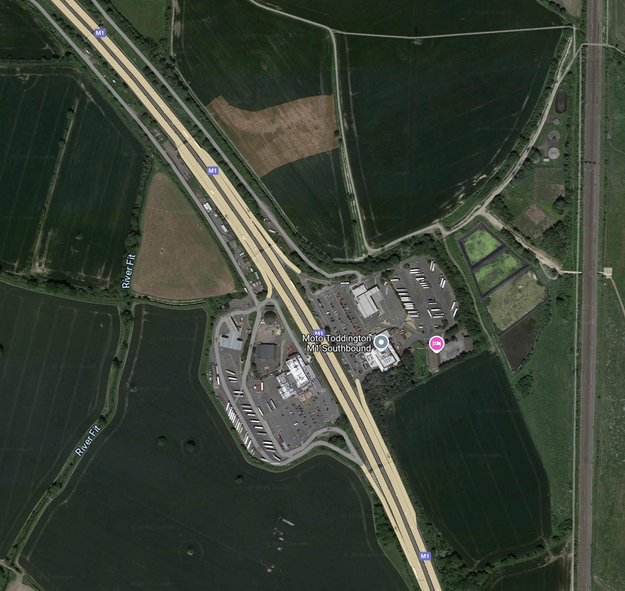
Note.
- There is land around the services that could be used to create more parking for hydrogen coaches.
- There doesn’t appear to be much space for a large wind farm to provide electricity to generate hydrogen.
- The Midland Main Line runs up the Eastern side of the map.
I wonder, if hydrogen could be brought to a refuelling site at Toddington services by the use of rail wagons.
Newport Pagnell Services
Newport PagnellServices is 86.5 km. from the Southern end of the M1.
This map shows the services.
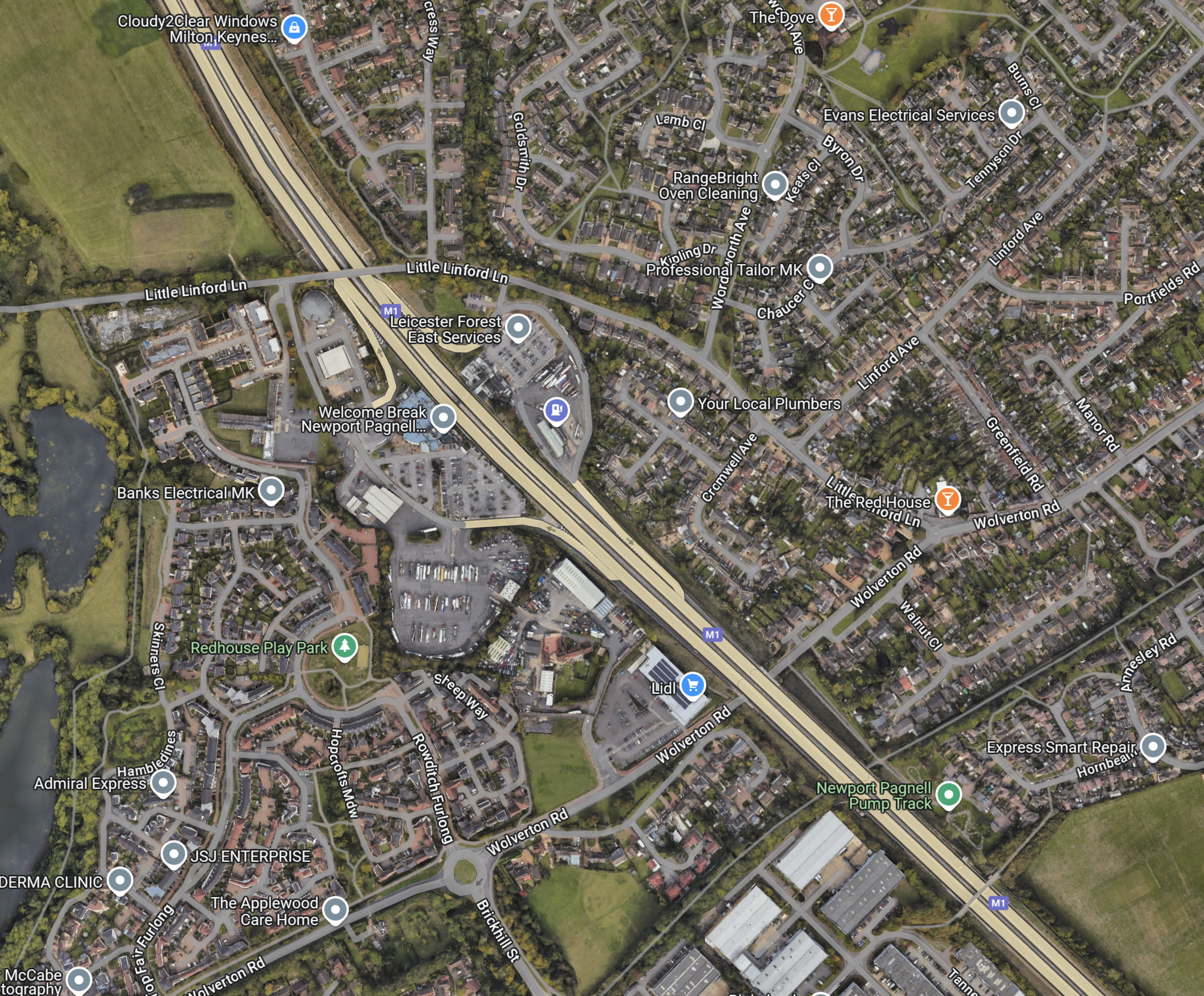
Note.
- The services are labelled as Leicester Forest East.
- The services are tightly surrounded by houses.
I’m not sure the residents would like to have a hydrogen refuelling station in their midst.
Northampton Services
Northampton Services is 104.5 km. from the Southern end of the M1.
This map shows the services.
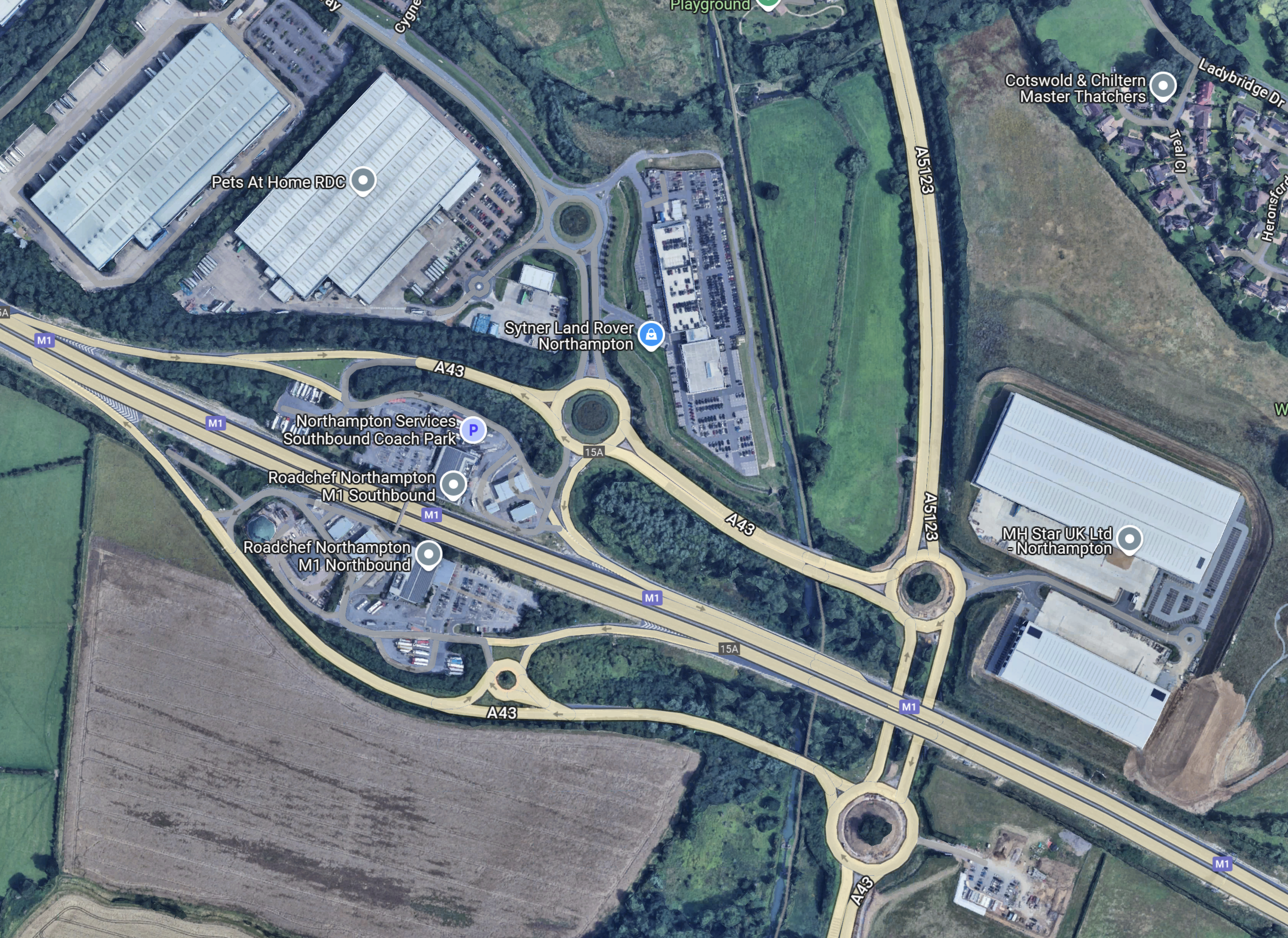
Note.
- It looks a rather complicated services.
- It might be too far from London.
- Provision of hydrogen might be difficult.
I think that this is another services that we can discount.
Watford Gap Services
Watford Gap Services is 120.8 km. from the Southern end of the M1.
This map shows the services.
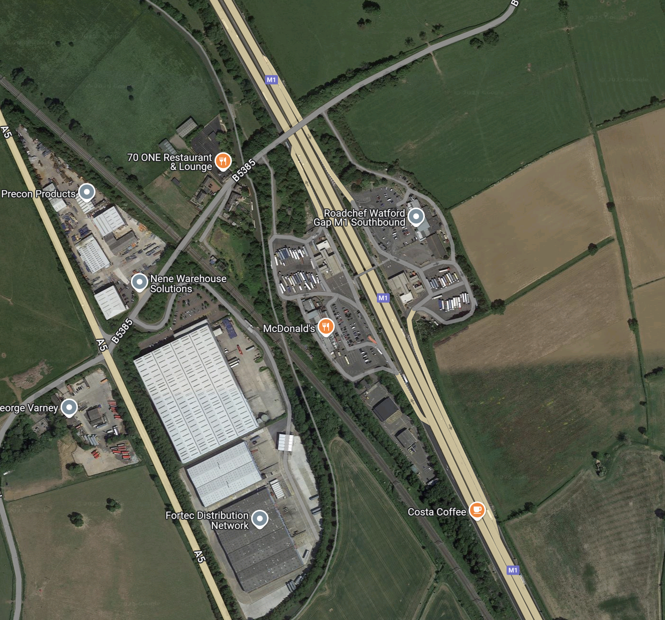
Note.
- There is land around the services that could be used to create more parking for hydrogen coaches.
- There doesn’t appear to be much space for a large wind farm to provide electricity to generate hydrogen.
- The West Coast Main Line runs through the centre of the services.
I wonder, if hydrogen could be brought to a refuelling site at Watford Gap services by the use of rail wagons.
Rugby Services
Rugby Services is 137.8 km. from the Southern end of the M1.
This map shows the services.
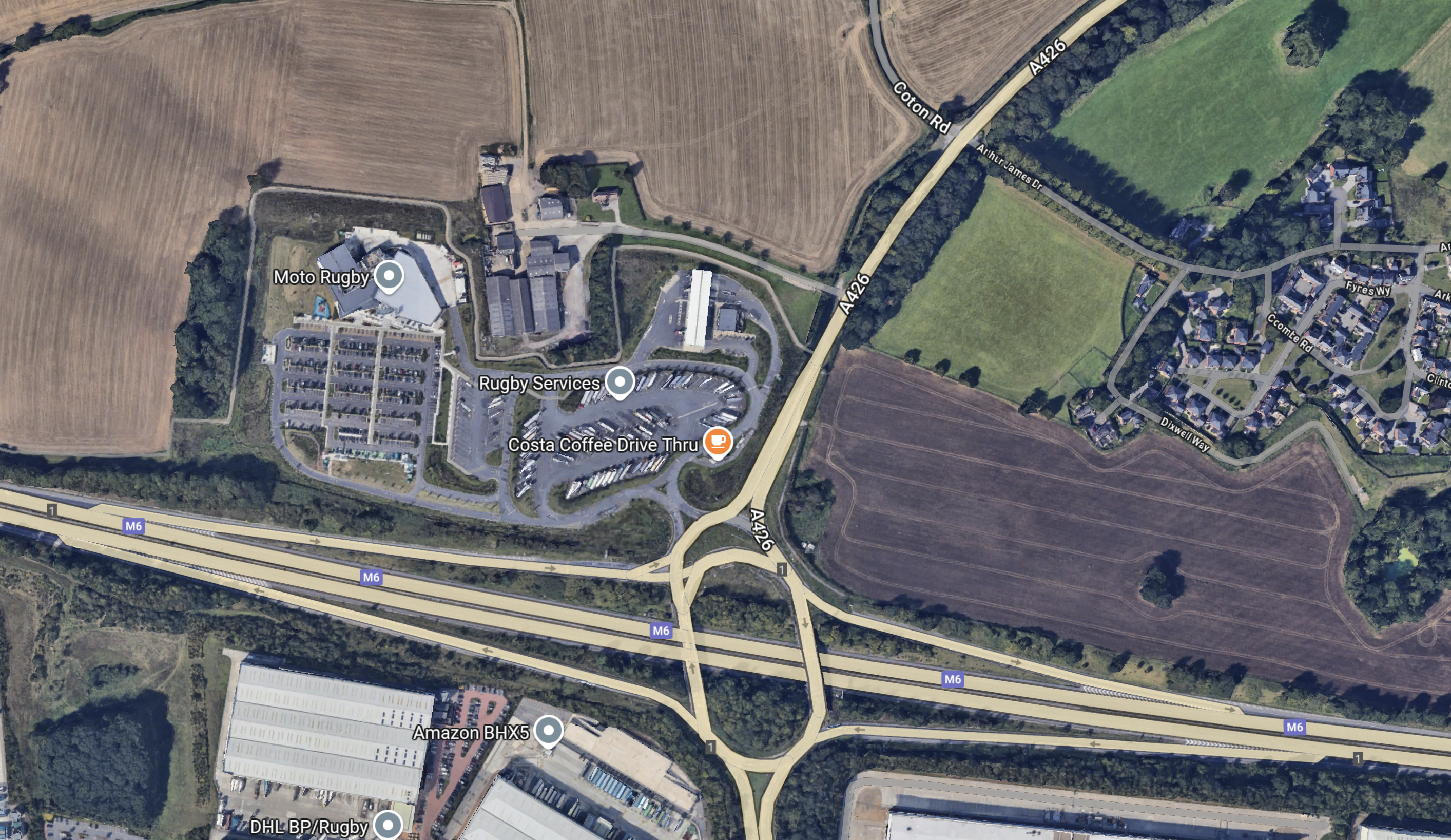
Note.
- There is land around the services that could be used to create more parking for hydrogen coaches.
- It is at Junction 1 of the M6.
There is also a gas compressor station nearby, so I wonder, if a HiiROC system could be located here to extract hydrogen from the natural gas.
This map shows the location of the Churchover compressor station, with relation to Rugby services.
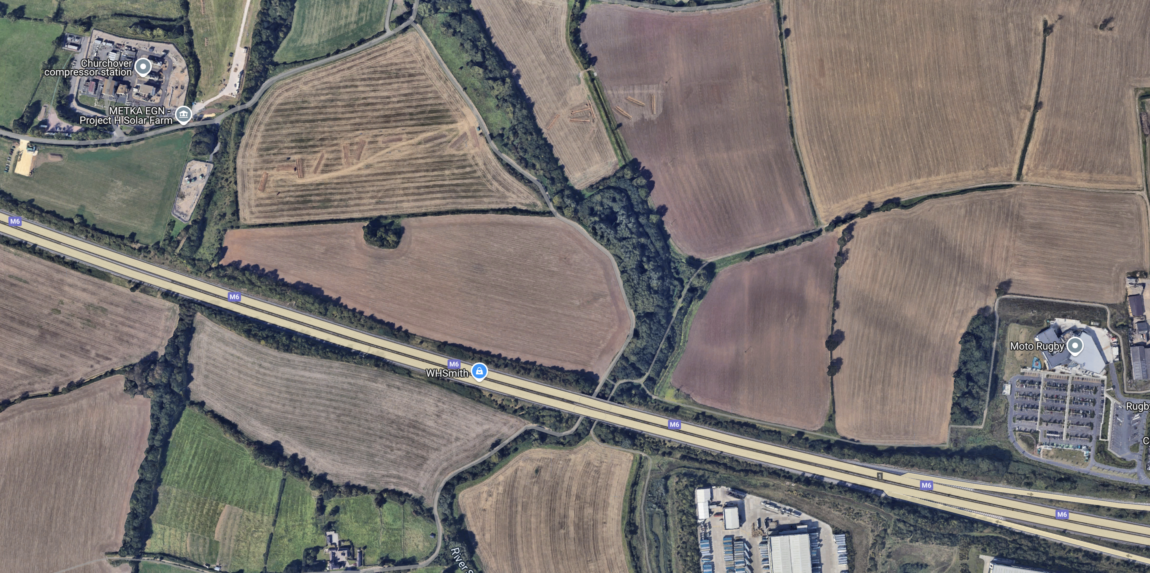
Note.
- The compressor station is in the North-West corner of the map.
- Rugby services are in the South-East corner of the map.
- From labels on the map it appears, a solar farm might be planned by the compressor station.
With a system like HiiROC creating turquoise hydrogen from natural gas, this could be a major filling station for hydrogen-powered trucks, coaches and cars.
Conclusion
It looks to me, that Toddington services would be best, but there would need to be a large increase in capacity, if a large number of hydrogen coaches, were going to fill up at Toddington for their trip into London.
The alternative would be to give the coach a large enough hydrogen tank for a complete round trip.
Northern Eden Project Worth £125 million Gets Green Light
The title of this post, is the same as that of this article on The Times.
These are the first two paragraphs.
Plans to transform the seafront of a deprived town into a £125 million northern outpost of the Eden Project have been given the green light.
Councillors in Lancashire approved plans for the site on Morecambe seafront which it is hoped will attract around a million visitors and create 400 jobs.
I think the Eden Project Morecambe could be a real Northern success.
Here’s my reasoning.
Location, Location, Location
These are the three most important factors with any house, building or property.
Morecambe has a superb location for visitors coming by car or train, as is close to both the M6 Motoway and the West Coast Main Line.
I wrote about getting to the Eden Project in Getting To The Proposed Morecambe Eden Project By Train.
I suspect visitors coming by road, would drive to a suitable Park-and-Ride and then take a train.
Lancaster Will Be A High Speed Two Station
Lancaster will be served by the following High Speed Two services.
- London Euston – Two hours and three minutes – One tph
- London Old Oak Common – One hour and fifty-six minutes – One tph
- Birmingham Curzon Street – One hour and six minutes – One tph
- Crewe – Fifty-nine minutes – One tph
- Warrington Bank Quay – Forty-two minutes – One tph
- Wigan North Western – Thirty-one minutes – Two tph
- Preston – Seventeen minutes – Two tph
- Oxenholme – Twelve minutes – One tp2h
- Penrith – Thirty-five minutes – One tp2h
- Carlisle – Fifty-two minutes – One tph
- Lockerbie – One hour and eleven minutes – One tph
- Edinburgh – Two hours and twelve minutes – One tp2h
- Motherwell – One hour and fifty-six minutes – One tp2h
- Glasgow – Two hours and twelve minutes – One tp2h
Note.
- tph is trains per hour.
- tp2h is trains per two hours.
- A shuttle train between Lancaster and the Eden Project Morecambe will probably add ten minutes.
High Speed Two will make the Eden Project Morecambe one of the best connected entertainment venues in the UK.
Avanti West Coast And TransPennine Express North Of Warrington Bank Quay After High Speed Two Opens
When High Speed Two opens, it is likely that North of Warrington Bank Quay station, the operating speed of this section of the West Coast Main Line will be faster than the current 125 mph, as the track will have been straightened and digital signalling will have been installed.
It will probably be at least 140 mph.
These trains will be running express passenger services on the route and will be able to match the speed and timings of High Speed Two’s Classic-Compatible trains to the North of Warrington Bank Quay station.
- Avanti West Coast’s Class 390 trains
- TransPennine Express’s Class 397 trains
- TransPennine Express’s Class 802 trains
There is likely to be savings of a few minutes on these services.
- Avanti West Coast – London Euston and Glasgow Central
- TransPennine Express – Manchester Airport, Manchester Piccadilly and Glasgow Central
- TransPennine Express – Liverpool Lime Street and Glasgow Central
Connections from the North-West of England and Southern Scotland will be fast and frequent.
Eden Project Morecambe Will Be A Day Trip For Greater North West England
An area defined by Carlisle, Blackburn, Manchester, Crewe, Chester, Liverpool and Blackpool will be close enough to have a day trip to the venue.
Eden Project Morecambe Is Unlikely To Be A Poor Attraction
The Eden Project Morecambe must be worth attending, but with twenty years experience of running a similar attraction in Cornwall, it is unlikely to be a failure.
Eden Project Morecambe Will Be Easier To Travel To Than The Original Eden Project For Many
I have never even been past the Eden Project in Cornwall, as it is not the easiest place to get to without a car.
I intend to go, but it will probably need two nights in a hotel to do it justice.
But Eden Project Morecambe could well be much shorter trip from London.
Currently, Avanti West Coast’s fastest time between London Euston and Lancaster are two hours and forty minutes, which would mean an under three hours trip both ways to and from Eden Project Morecambe. The Cornish site is probably nearly five hours by public transport.
Conclusion
All these factors should contribute to the success of the attraction.
Northern Powerhouse Rail – A New Line Between Liverpool And Manchester Via The Centre Of Warrington
In this article on Transport for the North, which is entitled Northern Powerhouse Rail Progress As Recommendations Made To Government, one of the recommendations proposed for Northern Powerhouse Rail is a new rail line between Liverpool and Manchester via the centre of Warrington.
I shall look at a few of the possibilities for various sections of the line starting at the Manchester end.
High Speed Two And Northern Powerhouse Rail Between Warrington/Lymm And Manchester Airport
This map clipped from High Speed Two’s interactive map, shows the route of High Speed Two in the area between Lymm and Manchester Airport.

Note.
- High Speed Two is shown in orange
- The blue dot is Manchester Interchange station at Manchester Airport.
- High Speed Two goes North to Wigan North Western station.
- High Speed Two goes South to Crewe station.
- High Speed Two goes East to Manchester and the East.
- The East-West Motorway is the M56 with Junction 7/8 in the middle of the map and Junction 9 with the M6, at the Western edge of the map.
This enlarged map shows High Speed Two between Manchester Airport and Junction 7/8 of the M56.

The colours of High Speed Two indicate the type of construction.
- Black is a bored tunnel. Only in the North East corner, where it continues to Manchester.
- Brown is a track between retaining walls. Used through Manchester Interchange or Airport station.
- Red is a viaduct.
- Yellow is a cutting.
This Google Map shows a similar area.

High Speed Two’s tracks will be on the South side of the Motorway and will be shared with Northern Powerhouse Rail.
- There is likely to be up to twelve trains per hour (tph) in both directions.
- I would think, that with modern signalling that the trains would be running at 140 mph or more.
- Between Manchester Airport and Warrington could be a line as between St. Pancras and Ebbsfleet on High Speed One.
This map clipped from High Speed Two’s interactive map, shows the M56 and High Speed Two around Junction 7/8 of the M56.

The colours are as before.
- The obvious way to build a new rail line between Manchester and Warrington, would surely be to create a rail junction just South of the Motorway junction.
- A line to Warrington could run along the South side of the Motorway.
- I also believe that there should be a connection between the High Speed Two lines to Manchester and Wigan North Western, to allow high speed services between Manchester and Barrow, Blackpool, Preston, Windermere and Scotland.
Building the rail junctions around the Motorway junctions would be a good idea for environmental and visual reasons.
Northern Powerhouse Rail would then continue to Junction 9 of the M56 Motorway.
This Google Map, shows the M56 around Junction 9 with the M6.

Note.
- The M56 running East-West.
- The M6 running North-South.
- Lymm services to the North-West of the junction.
- Lymm is to the North-East and Warrington is to the North-West of the junction.
Would it be possible for to run South of the M56 and then turn North to run along the Western side of the M6 towards Warrington?
I very much feel, that with modern 3D software, an engineer with expertise in extreme knitting could thread a double-track line through to take a North-Western route towards Warrington.
The Bridge Across The Mersey
If you look at maps of the area, there is a big problem of water between Junction 9 of the M56 and Warrington town centre, with its two stations of Warrington Bank Quay and Warrington Central, both of which have services to Liverpool Lime Street station.
The problem is the Manchester Ship Canal.
I then noticed a bridge to the South East of the town centre, which is shown in this Google Map.

It may look like it has got more than a touch of the dreaded iron moths, but it certainly looks like it was once a double track rail line.
The bridge was on the Warrington and Altrincham Junction Railway, which did what you would expect from the name.
This Google Map shows the track of the railway either side of the bridge.

Note the bridge in the centre of the map and the green scar of the former railway running East-West across the map.
To the East the green scar of the railway can be picked out all the way to M6.

Note.
- The bridge is at the West over the Manchester Ship Canal.
- The green scar of the Warrington and Altrincham Junction Railway can be followed all the way to the M6,
- I think the track is now a footpath, as it is marked on the map with a dotted white line.
I would be interested to know, if it could take a modern double track railway.
This Google Map shows an enlarged view of where the green scar of the Warrington and Altrincham Junction Railway goes under the M6.

Note the dotted white line marking the railway, towards the top of the map.
Would it be possible to design a track layout, where Northern Powerhouse Rail came up the Western side of the M6 and was able to connect to Warrington?
I certainly believe it’s a possibility.
Warrington Bank Quay Station
To the West of the bridge over the Manchester Ship Canal, the Warrington and Altrincham Junction Railway ran through low-level platforms at Warrington Bank Quay station.
This Google Map shows Warrington Bank Quay station.

This picture shows a freight train passing under Warrington Bank Quay station.

Note.
- There are four North-South platforms on the West Coast Main Line.
- The Warrington and Altrincham Junction Railway passes East-West under the four main platforms.
- Low levels platforms used to handle passengers on the East-West lines.
- I was looking to the East in the picture.
- The tracks continue to the West on the route of the former St. Helens Railway, which is now a freight route.
- The map shows the tracks curving sharply round one of the meanders of the River Mersey.
Warrington Bank Quay station is on a congested and tight site, but by using some of the spare railway land, I feel it could rebuilt to be an excellent station for Warrington.
Warrington Bank Quay Station As An Interchange
Warrington Bank Quay station could be an excellent and efficient interchange between High Speed Two and Northern Powerhouse Rail.
There are also local services from the station, which could be useful for some travellers.
Between Warrington Bank Quay Station And Widnes
This Google Map shows the Mersey estuary between Warrington Bank Quay station and Widnes.
Note.
- Warrington is in the North-East corner of the map, with Warrington Bank Quay station shown by a red station symbol.
- The new Mersey Gateway bridge is in the South-West corner of the map.
- The River Mersey meanders between the bridge and Warrington.
- Fiddlers Ferry power station can be picked out in the nearest meander of the Mersey to the bridge.
- The dark straight line below the river is the Manchester Ship Canal.
- There is currently a freight line on the North bank of the river.
This Google Map shows Fiddlers Ferry power station, with the railway between the now-decommissioned power station and the River Mersey.

Note.
- Fiddlers Ferry will become an employment site.
- It could even be a good place for a depot for Northern Powerhouse Rail.
- I think there’s scope to increase the operating speed of the railway along the Mersey.
Could it even be an electrified high speed line with a 125 mph operating speed?
Between Widnes And Liverpool Lime Street
The trains coming from Warrington could join the Liverpool Branch of the West Coast Main Line at Ditton East Junction.
The route between Ditton East Junction and Liverpool Lime Street has the following characteristics.
- It has four tracks.
- It is 10.6 miles long.
- Avanti West Coast’s expresses typically take twelve minutes for the trip without stopping.
- The stations on the route; Liverpool South Parkway; West Allerton, Mossley Hill and Edge Hill, all have one platform per line.
- It is fully electrified.
- Lime Street station has recently been updated with longer platforms and a higher capacity approach to the station.
- Some local services have already been moved to Merseyrail’s Northern Line.
- Stopping services on the route have their own platforms.
I believe that with the installation of full digital signalling and a degree of automatic train control, as far as Crewe and Warrington Bank Quay stations, that the following services could be handled.
- Six tph – Northern Powerhouse Rail – Liverpool and Manchester Airport and Manchester Piccadilly
- One tph – East Midlands Railway – Liverpool and Nottingham
- Three tph – High Speed Two – Liverpool and London Euston
- One tph – High Speed Two – Liverpool and Birmingham Curzon Street
- Two tph – London North Western – Liverpool and Birmingham and London Euston
Note.
- This is only 13 tph.
- Avanti West Coast services would be replaced by High Speed Two.
- TransPennine Express services would be replaced by Northern Powerhouse Rail
- The Liverpool and Nottingham service may or may not go via Ditton East junction.
If the capacity on this branch could be raised to 15 tph, that would be only be a train every four minutes, or half the frequency, that will eventually be operational on Crossrail and Thameslink. It would also be less than the 18 tph frequency of High Speed Two.
Conclusion
This simple exercise has proven to me, that a high speed line could be built between Manchester Airport and Liverpool Lime Street station.
- Several sections of the route could have an operating speed of 125 mph or more.
- By running the tracks along the M56 and M6, visual and aural intrusion could be minimised.
- The line along the Mersey through Warrington could be a valuable part of the route.
- West of Warrington, much of the infrastructure needed, appears to be in place and it would only need to be upgraded.
There was a large and extremely pleasant surprise at the Liverpool end.
The approach to Liverpool Lime Street is two fast and two slow lines, and I believe, that this section of the route could handle up to say 15 fast trains and six stopping trains per hour, with full digital signalling.
Unlike London and Manchester, I doubt that Liverpool will need a tunnel to access the City Centre.
I also believe that after its refurbishment of the last couple of years, Lime Street could be substantially ready for High Speed Two and Northern Powerhouse Rail.
Project Management Recommendations
This project divides neatly into three.
- Between Manchester Airport and Warrington along the route of the M56 and M6.
- Reconstruction, upgrading and electrification through Warrington and the rebuilding of Warrington Bank Quay station.
- Reconstruction, upgrading and electrification between Warrington and Liverpool.
The first project will be a major one, involving the construction of nearly twenty miles of new electrified railway, with numerous viaducts, bridges and a large junction at High Legh with High Speed Two.
The other two projects would be a lot simpler and would involve turning twenty miles of double-track freight line into a modern electrified railway.
I would construct projects 2 and 3 early in the schedule, as it would give Warrington a new Bank Quay station. A passenger service to Liverpool Lime Street, could also be opened if required.
