Public Inquiry Into Northumberland Line Due To Open This Week
The title of this post, is the same as that of this article on the News Post Leader.
It is also a good summary of where the various councils are with the reopening of the Northumberland Line.
The article says that work should start next summer and trains will run in 2024.
Reopening The Askern Branch
On October 27th this Beeching Reversal Project was given £50,000 to build a case for reopening.
These are my thoughts.
The Askern Branch Line
This description of the Askern Branch Line is from Wikipedia.
The Askern branch line is a railway line which runs in North, South and West Yorkshire in England. The stretch of track runs from Shaftholme Junction north of Doncaster (on the East Coast Main Line between Doncaster and York), via Askern, Norton and Womersley to Knottingley, where it joins the Pontefract Line.
This map was also clipped from Wikipedia.
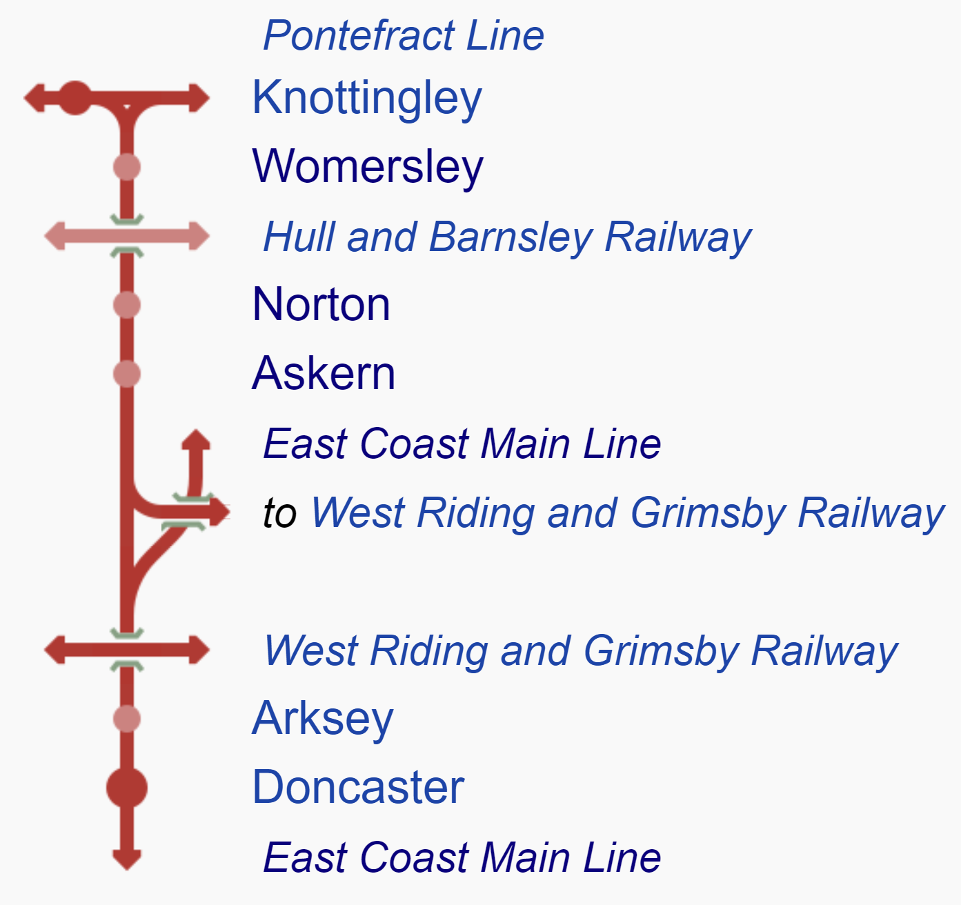
Note.
- Shaftholme junction is where the Askern Branch splits from the East Coast Main Line.
- There are three closed stations on the Askern Branch; Askern, Norton and Womersley.
- Between Shaftholme junction and Knottingley West junction, on the Pontefract Line is 10.7 miles.
- The operating speed of the line is between twenty and fifty mph.
Unbelievably, in those 10.7 miles there are nineteen level crossings.
Current Passenger Services
The only passenger services on the line are Grand Central‘s services between London King’s Cross and Bradford Interchange.
- Grand Central are an open-access operator.
- Grand Central ran the first service in 2007.
- There are four trains per day (tpd) in both directions.
- They call at Doncaster, Pontefract Monkhill, Wakefield Kirkgate, Mirfield, Brighouse, Halifax and Low Moor.
Perhaps, if they stopped at a station on the Askern Branch Line, it would give their finances a lift.
Freight Services
There are up to four freight services per hour on the line.
Askern Station
Askern station used to serve the village of Askern.
- Askern has a population of about 6,000.
- Askern used to be a spa town.
- But then coal was discovered and it became a mining village.
- Do spas and coal mining make a good mix? I doubt it.
- Eventually the station closed in September 1948.
- There is a level crossing at the station.
The village is now developing and there is pressure for the reopening of the station.
Railfuture has backed the reopening.
Norton Station
Norton station used to serve the village of Norton.
- Norton has a population of about 5,000.
- The station closed in September 1948.
- There is a level crossing at the station.
There appears to be no pressure to reopen the station, although the site is protected.
Womersley Station
Womersley station used to serve the village of Womersley.
- Womersley has a population of a few hundred.
- The station closed in September 1948.
- There is a level crossing at the station.
There appears to be no pressure to reopen the station.
Would This Project Be Better Described As Reopening Askern Station?
I can’t find any reference to reopening Norton and Womersley stations, so perhaps Reopening Askern Station would be closer to the reality.
A New Askern Station
This Google Map shows the site of the former station.
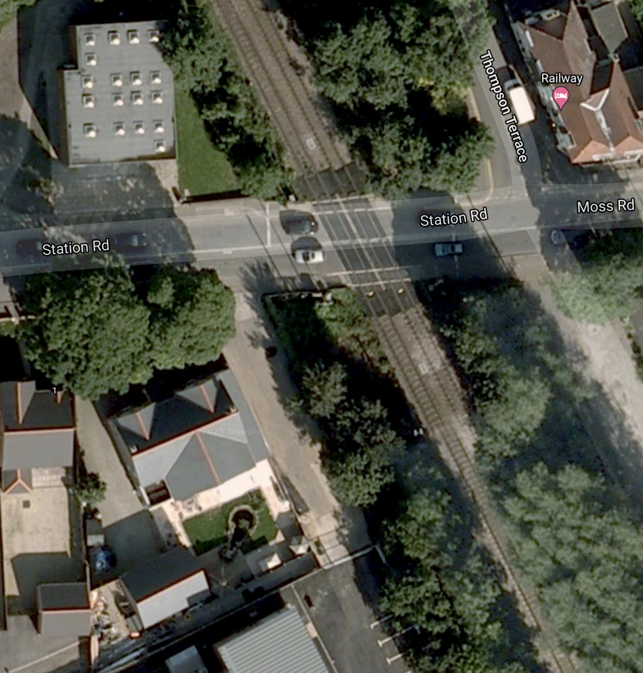
This could be a challenging station to design depending on the brief.
Services At A New Askern Station
I suspect that some or perhaps all of Grand Central’s Kings Cross and Bradford Interchange services will call.
But these don’t go to Leeds and I suspect that a service is needed to and from Leeds.
Will The Askern Line Be Electrified?
Who knows?
Reopening Corsham Station
On October 27th this Beeching Reversal Project was given £50,000 to build a case for reopening.
Corsham is a town in Wiltshire.
- It has a population of 13,000
- It is very much a military town, with numerous defence establishments, some of which are deep underground in former bath stone quarries.
- Corsham station closed in 1965.
As this Google Map shows the Great Western Railway passing through the town.
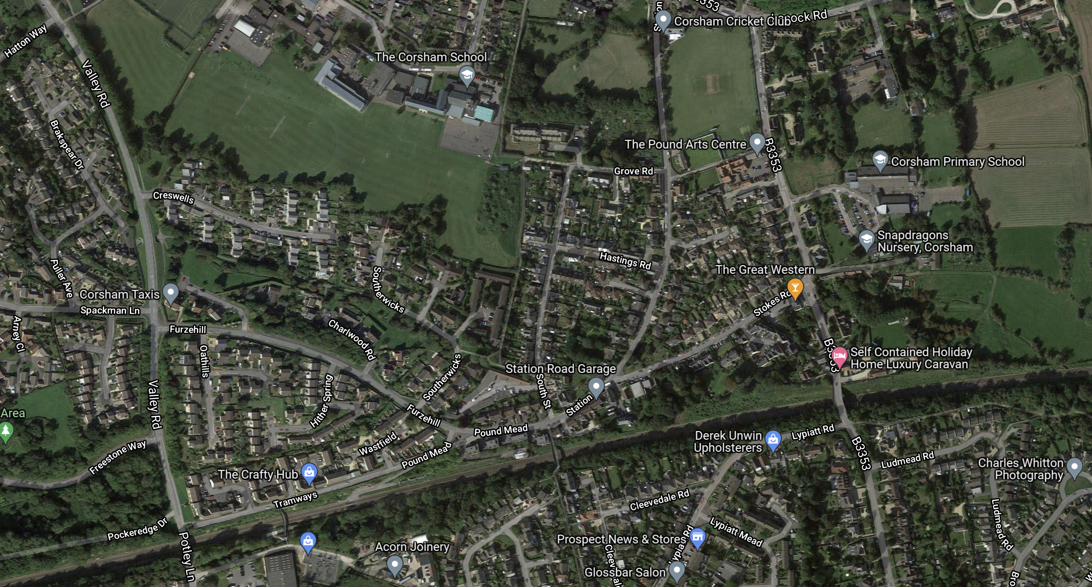
The dark scar of the railway across the map towards the bottom is clearly visible.
This second Google Map shows the site of the former station.
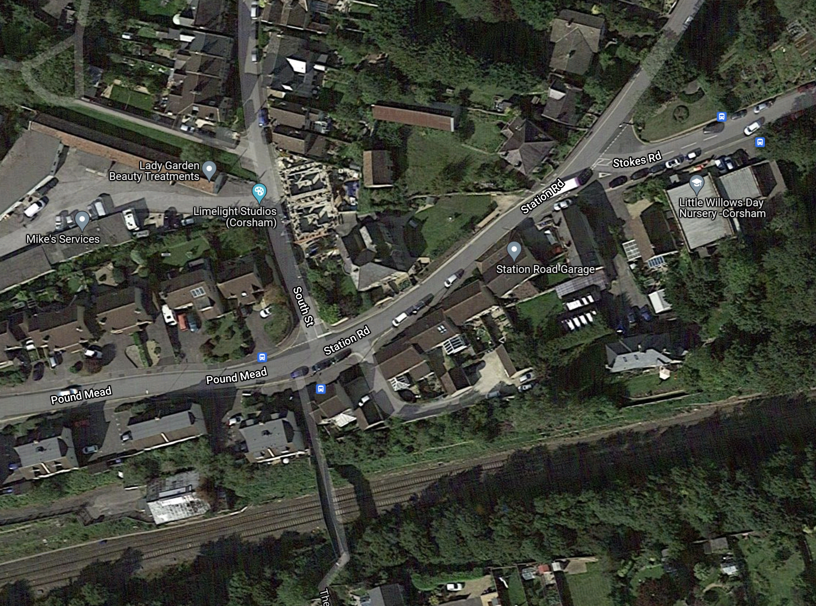
Note.
- Station Road is a bit of a giveaway.
- There is a footbridge over the double-track railway. Note the shadow.
- The railway is not electrified, but could be in the future.
- Chippenham station is to the East and Bath Spa station is to the West.
- The station was in a deep cutting on the approach to Box Tunnel, which is to the West.
I doubt that designing and building a new Corsham station will be a challenging project.
These are my thoughts on other issues.
Military Issues
The Wikipedia entry for Corsham has a section called Defence, which lists well over half-a-dozen defence sites.
Could these be a reason for the new station?
- Just like many other businesses and families, does the Ministry of Defence feel it should decarbonise?
- Are large numbers of employees and visitors driving in from Swindon and Bristol?
How many new stations would cut the country’s carbon footprint?
Services
Currently, it appears the only services going through Corsham are the Paddington and Bristol Temple Meads service
- There are two trains per hour (tph)
- The trains call at Reading, Didcot Parkway, Swindon, Chippenham and Bath Spa.
- Between Chippenham and Paddington is fully-electrified
- Trains run between Bristol Temple Meads and Chippenham, which is a distance of 24.4 miles on diesel.
These trains could stop, but would that slow the services?
Perhaps alternate services would stop at only one of Corsham and Chippenham. But that would mean the train couldn’t be used between those two stations.
An alternative philosophy would be to electrify between Chippenham and Bath Spa, so that the stops would be faster , as acceleration would be under electric power.
- Box Tunnel has been prepared for electrification.
- This would be thirteen miles of new electrification.
- Trains would run between Bristol Temple Meads and Bath Spa, which is a distance of 11.5 miles on diesel.
But the good citizens of Bath, might object to electrification through Sydney Gardens and the City Centre.
If they do object, an alternative would be to electrify between Bathampton junction and Chippenham.
- As before Box Tunnel would be electrified.
- This would be eleven miles of new electrification.
- Trains would run between Bristol Temple Meads and Bathampton junction, which is a distance of 13.7 miles on diesel.
Bath would not be despoiled by electrification.
Battery-Electric Trains
I touched on electrification in the previous section and I believe it would be reasonably easy to electrify between Chippenham station and Bathampton junction.
This would mean that there would be just 13.7 miles for the train to power itself between Bristol Temple Meads and Bathampton junction.
As it is 27.4 miles in total with perhaps a twenty minute wait in Bristol Temple Meads station, I believe this would be within the battery range of a Hitachi Intercity Tri-Mode Battery Train, which is described in this Hitachi infographic.

Note.
- Hitachi haven’t disclosed the range of the train on battery power alone.
- Twenty minutes in Temple Meads station is enough to fully charge the battery.
If the train could be recharged at Temple Meads station, the battery range needed would be just fifteen miles.
Conclusion
All stakeholders would appear to benefit from this new station.
Bradford Seeks Support On Rail Project Which Could Deliver £30bn Benefits
The title of this post is the same as that of this article on Rail Technology Magazine.
This is the first paragraph.
Delivery of a new city centre railway station in Bradford is estimated to boost the city’s economy by £30bn over ten years, with Bradford Council now seeking government support to deliver the major rail project.
The article also says that the the station, will be built on the site of St James Market, which is owned by the Council.
This Google Map shows the market and the surrounding roads and railways.
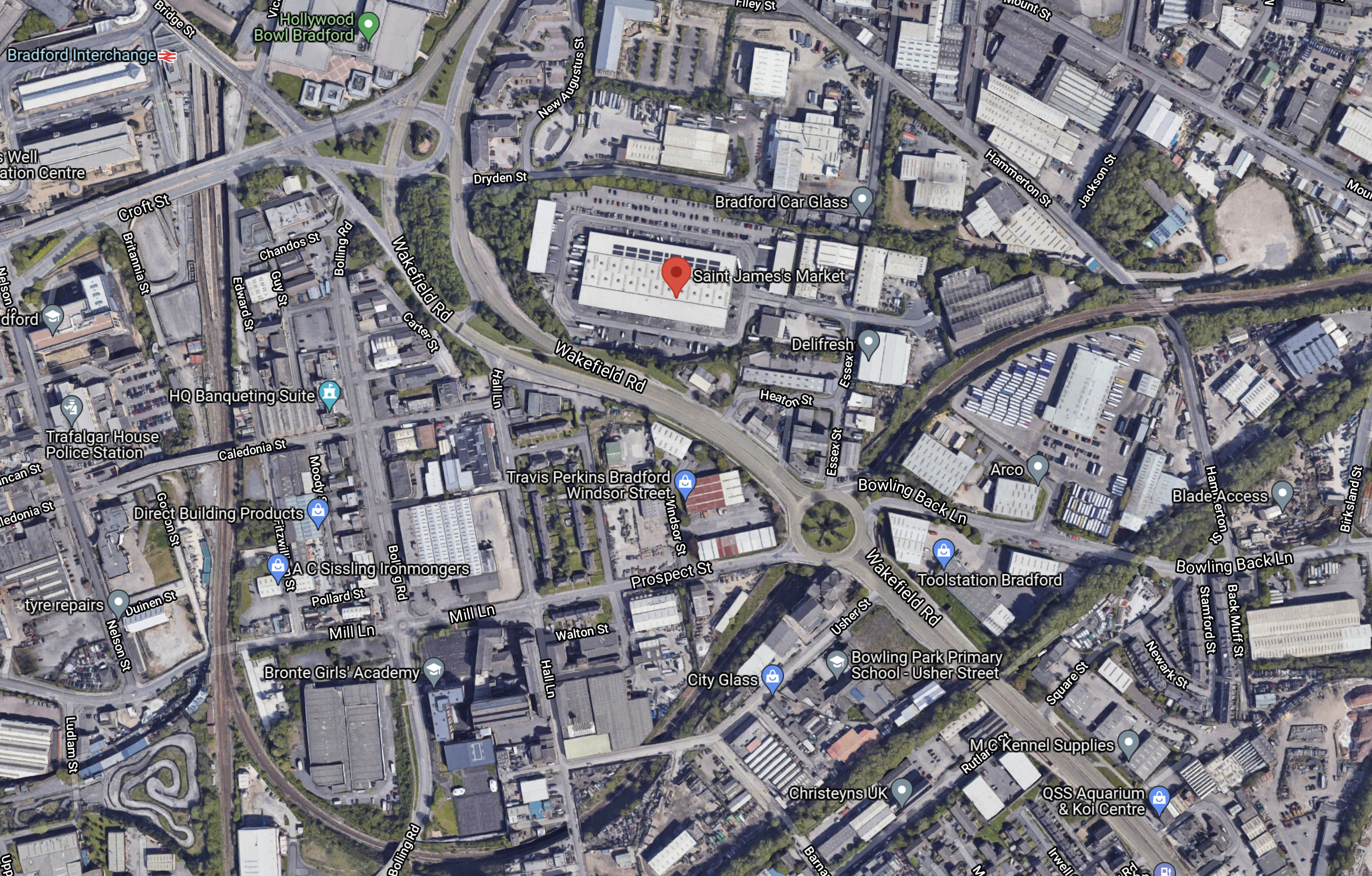
Note.
- Bradford Interchange station is in the North-West corner of the map.
- St. James Market is marked by the red arrow in the middle of the map.
- The railway Between Leeds and Bradford Interchange stations via New Pudsey station curves in a loop South of the market.
- The railway going South from Bradford Interchange goes to Bradford Low Moor and Halifax stations, before taking the Calder Valley Line via Hebden Bridge to Manchester Victoria station.
I think it would be feasible to build the station on the current route between Leeds and Bradford Interchange stations, with perhaps a mixture of through and bay platforms.
This second Google Map, shows Mill Lane Junction, where the lines from New Pudsey and Bradford Low Moor stations join South of Bradford Interchange station.
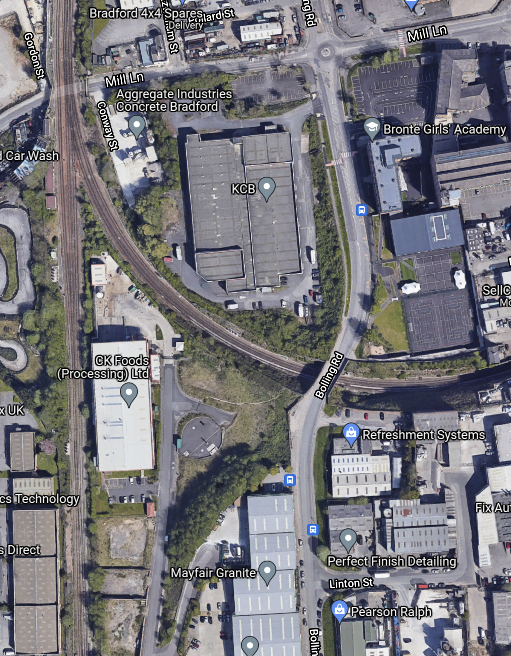
Note.
- Bradford Interchange station is on the rail line to the North.
- The proposed new Bradford station and the existing New Pudsey station are on the rail line to the East.
- Bradford Low Moor station is on the rail line to the South.
It would appear that an extra chord should be added to the junction to allow trains between Manchester Victoria and Leeds via the Calder Valley Line can call at the new station in Bradford.
Current trains between Manchester Victoria and Leeds using this route have to reverse at Bradford Interchange. The new station and the extra chord would avoid this.
Conclusion
I think that this proposal has possibilities.
Skelmersdale Railway Station Could Finally Happen – If Government Says Yes
The title of this post, is the same as that of this article on Lancs Live.
The article is a good summary of why Skelmersdale needs a station.
But it doesn’t mention that any service to Skelmersdale will probably go via Merseyrail’s new station at Headbolt Lane.
Crossrail Formally Hands Paddington Station Over To TfL
The title of this post, is the same as that article on Ian Visits.
Ian says this about the current status of the stations.
This is the sixth of the Elizabeth line stations to be transferred over to TfL, following Custom House, Farringdon, Tottenham Court Road, Woolwich and Liverpool Street stations, which leaves only Canary Wharf, Whitechapel and the late running Bond Street to go.
Paddington station certainly looked very ready, when I visited yesterday and took the pictures in The Main Crossrail Entrance At Paddington Station.
The New Cameron Bridge Station On The Levenmouth Rail Link
The reinstated Levenmouth Rail Link, will have two stations; Leven and Cameron Bridge.
This Google Map shows the River Leven and the remains of the old railway as they run West from Leven.
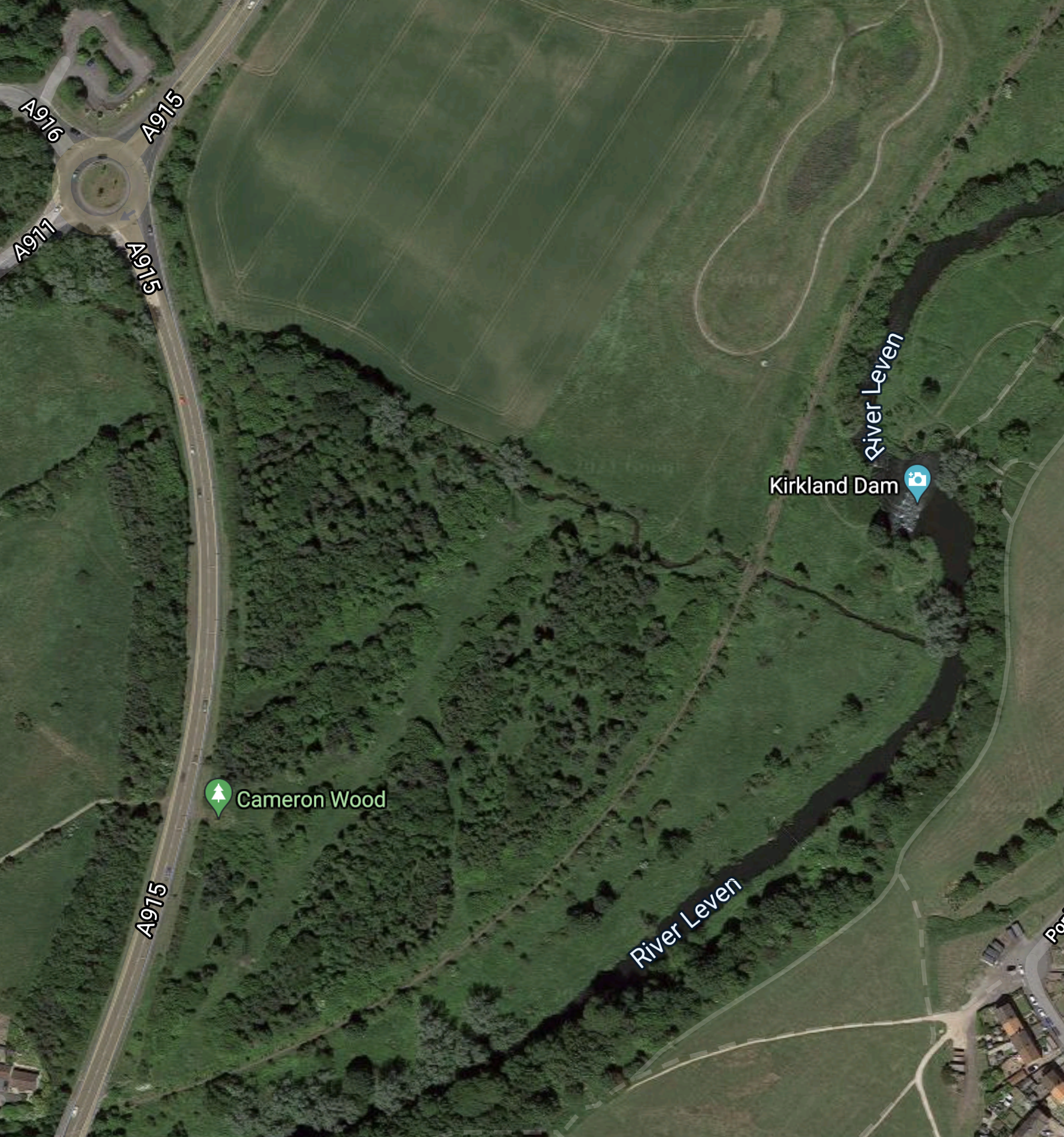
Note.
The River Leven runs South-West to North-East across the map.
The track of the old rail link runs towards Leven along the North Bank of the river.
This Map from this page on the Network Rail web site, shows the location of the new Cameron Bridge station.
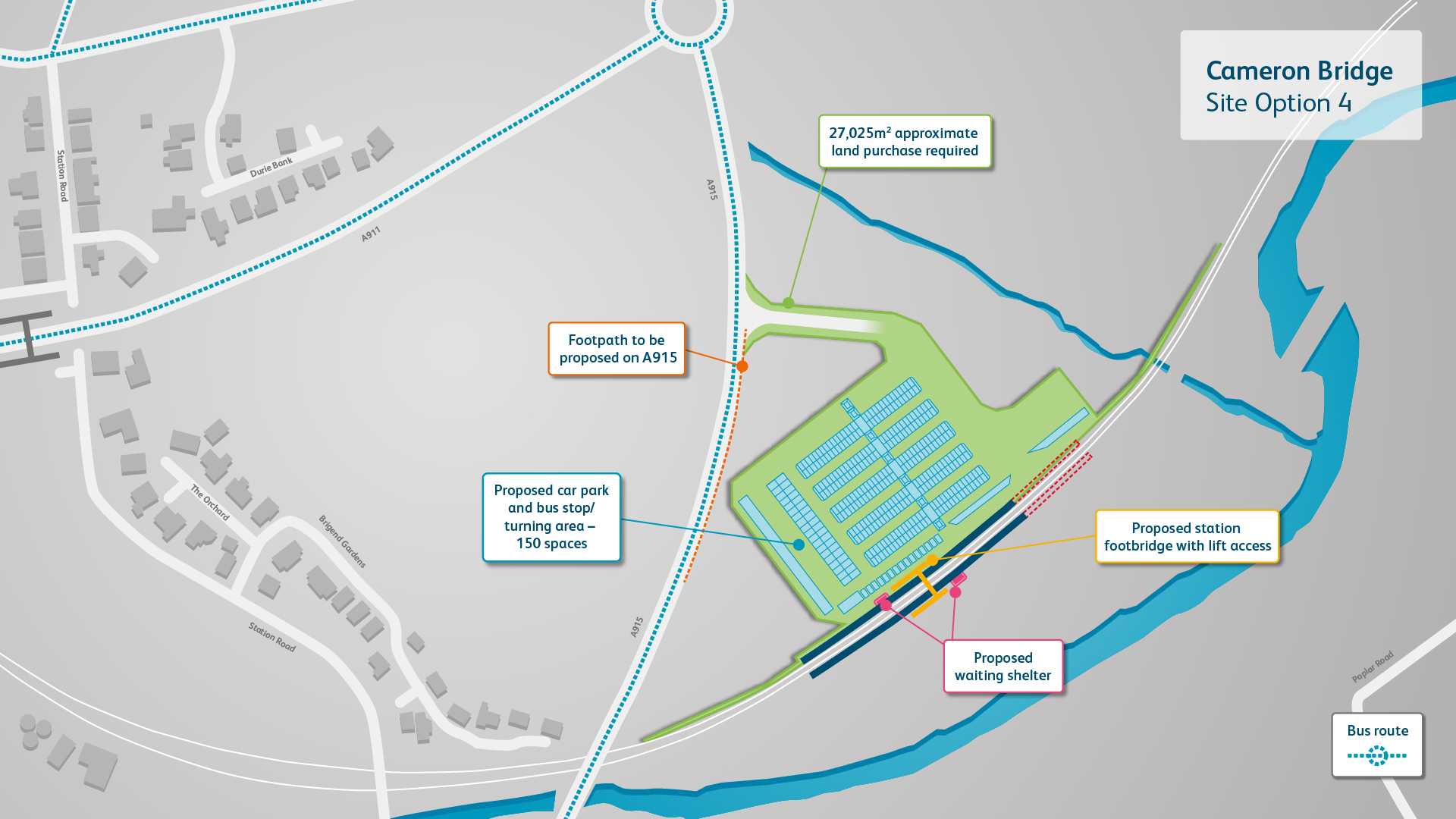
Note.
- The station will be to the East of the A915 road.
- Cameron Bridge station will have two platforms.station has two platforms.
- There will be 150 car parking spaces.
- There is space for a bus stop and turning area.
- There will be two waiting shelters.
- The platforms look like they could be extended if needed.
Unlike Leven station, there will be a bridge with lifts for passengers.
Related Posts
The New Leven Station On The Levenmouth Rail Link
Service Provision On The Levenmouth Rail Link
Trains On The Levenmouth Rail Link
The New Leven Station On The Levenmouth Rail Link
The reinstated Levenmouth Rail Link, will have two stations; Leven and Cameron Bridge.
This Google Map shows the mouth the the River Leven.
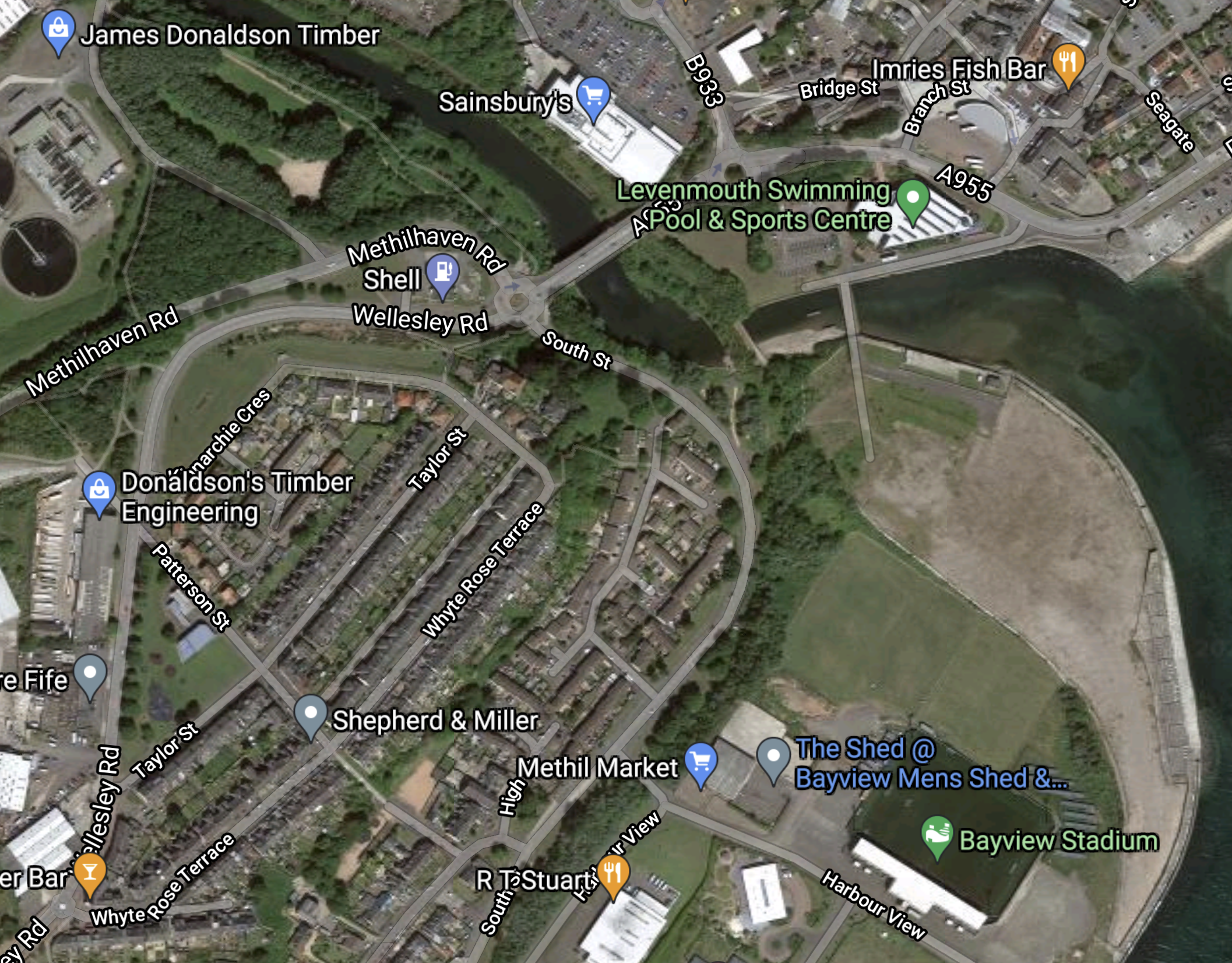
The key point to note is the Sainsbury’s supermarket, which is to the North of the Riven Leven, close to the A955 bridge across the river.
This Map from this page on the Network Rail web site, shows the location of the new Leven station.
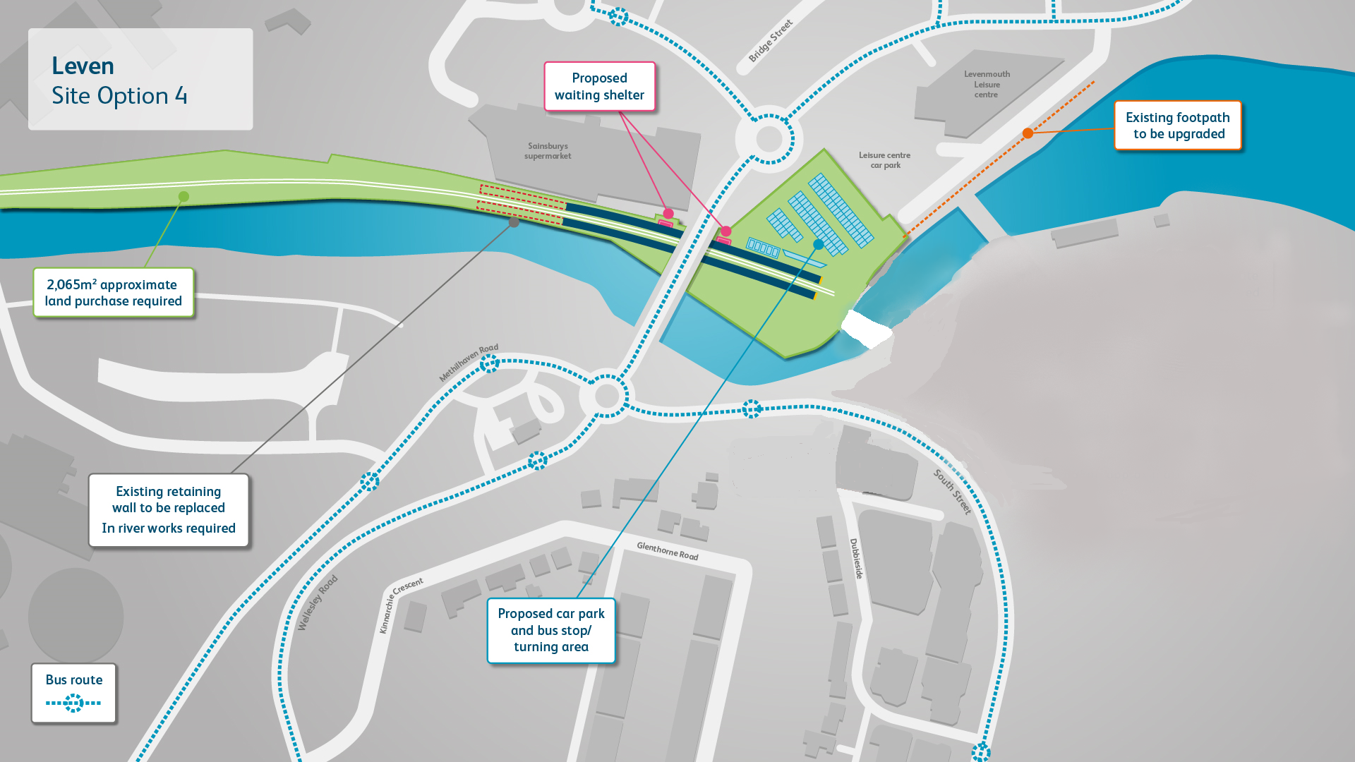
Note.
- Leven station has two platforms.
- There is a car park.
- There is space for a bus stop and turning area.
- There are two waiting shelters, both on the same platform
- The platforms look like they could be extended if needed.
It appears that passengers will cross the line by walking past the end of the line.
This map shows a close-up of the bridge over the River Leven.
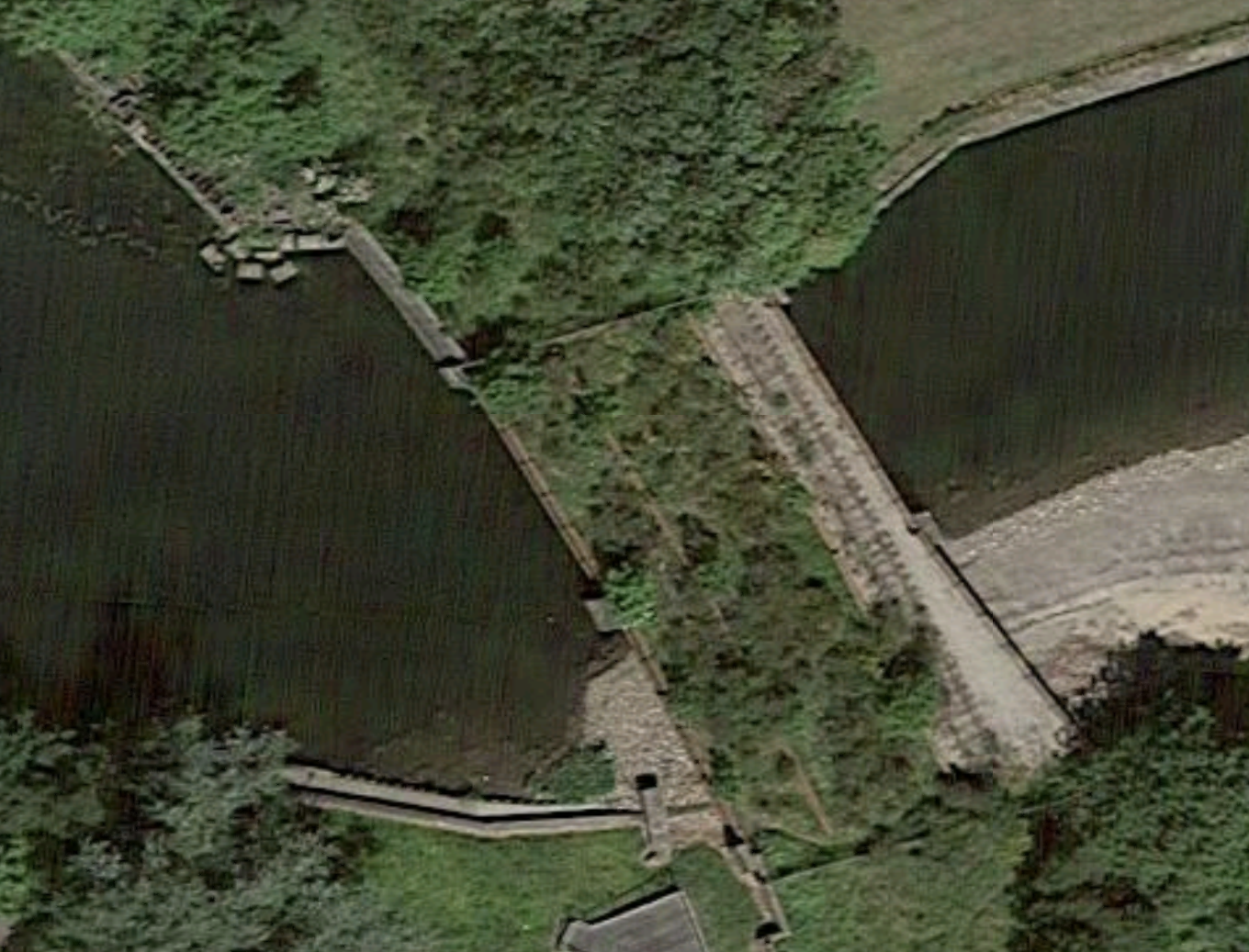
It used to connect the railway to the coal-fired Methil power station.
Some of the track is still visible.
Is provision being made in the design of Leven station, so that the rail link can be extended across the River Leven to a second station near the Bayview stadium or to allow the development of housing or industrial sites along the Forth of Firth?
Conclusion
It looks to be a good scheme, which connects to the centre of the town and could be developed with bus and walking links for onward travel.
Related Posts
The New Cameron Bridge Station On The Levenmouth Rail Link
Service Provision On The Levenmouth Rail Link
Will Hitachi ABB Power Grids Technology Be Used At Headbolt Lane Station?
Today, I was sent a link to the North Cheshire Rail User Group’s Newsletter for Spring 2021.
Current Progress on Merseyrail’s Class 777 Trains
This is said in the newsletter about the progress of the new Class 777 trains.
At a recent meeting of the Liverpool City Region rail user groups hosted by Liam Robinson, Chair of
Merseytravel, a short presentation was given detailing progress in bringing the new Class 777 Stadler fleet into
operation. NCRUG has been keeping a keen watch on the introduction of this new fleet; later model Class 777’s
have the ability to leave the 3rd rail and operate under battery power for 20 miles or more with a full load thus
permitting expansion of the Merseyrail network beyond its current limits.Particularly of interest in our patch is the Ellesmere Port to Helsby line, although at one point in the meeting I
did raise the concept of ultimately having a complete Merseyrail service circling the Mersey Estuary on a metro
styled basis Ambitious certainly, but unrealistic as a long-term goal? There would be considerable work required
at Liverpool south Parkway to connect the Merseyrail line to the network, however the terrain is suitably flat and
the trains will be capable. This obvious evolution of the network did seem to take the meeting by surprise.Unfortunately the much anticipated introduction of the Class 777’s has been delayed for a number of factors,
not least of all the pandemic but border issues and storage also play a part. Trails are taking place on the Kirby
and Ormskirk lines, and full introduction might not be until as late as next year. The Liverpool City Region has a
clearly defined set of (deliverable) objectives for development of the rail network and the expansion has been
prioritised with a line to Skelmersdale being top of the list and the first step of that being a new station at Headbolt
Lane, Kirby – plans are already well developed for this. It is expected to be this line where proof of concept trails
will be conducted for the battery powered 777’s, although Merseyrail does have authorisation to use Ellesmere
Port–Helsby on account of the low traffic movements on that line! Network expansion is being considered to
Widnes via Hunts Cross and possibly as far as Warrington, but when the question of Ellesmere Port–Helsby
was raised, the route, although under consideration, was not high on the priority list. I suspect it will be at least
several years away and I’m sure the delayed introduction of the type will not only come as a disappointment for
NCRUG but also the Community Rail Partnership and CWaC Council, who have funded a basic feasibility study
into possible demand. Therefore we are left with the Northern Trains service for the foreseeable future – 3 return
trains daily on the current schedule.
After reading this extract, I am puzzled. The original priority was to use the battery capabilities of the new Class 777 trains to extend the Ellesmere Port service to Helsby.
- Ellesmere Port and Helsby stations are 5.2 miles apart.
- Ellesmere Port has a two trains per hour (tph) service to Birkenhead and Liverpool.
- Ellesmere Port and Helsby stations are linked by a three trains per day (tpd) service.
Helsby station has comprehensive connections to Chester, Leeds, Liverpool, Manchester and Warrington Bank Quay station.
Two tph between Ellesmere Port and Helsby stations would certainly improve train services in the area and probably explains the disappointment shown by the writer of the newsletter.
So why have Merseyrail switched the emphasis to battery trains to Headbolt Lane and Skelmersdale from Ellesmere Port and Helsby?
Headbolt Lane Station
Headbolt Lane station is a station of an unusual design, which I wrote about in Headbolt Lane Station Fly-Through.
- Two platforms appear to face West towards Liverpool.
- One platform appears to face East towards Wigan and Manchester.
- The platforms meet head-on and a walkway runs between them to allow passengers to access all platforms.
- There appears to be provision for a fourth platform to serve Skelmersdale. which is to the East of Headbolt Lane.
I think the design means that access to all platforms is level, passengers can enter from both sides of the railway and the station doesn’t need an expensive bridge.
Between Kirkby And Headbolt Lane Stations
Headbolt Lane and Kirkby stations are a couple of miles apart at most. So were Merseyrail hoping to extend the third-rail electrification to Headbolt Lane station, but the Office of Rail and Road has more or less said that no more third-rail electrification is allowed. See ORR’s Policy On Third Rail DC Electrification Systems.
So are Merseyrail having to use battery power between Kirkby and Headbolt Lane stations?
If they are then they have the trains.
As according to the extract from the Cheshire Rail User Group’s Newsletter, the Class 777 trains have a range of twenty miles on battery power, then this should be no problem.
The Skelmersdale Shuttle
The design of Headbolt Lane station does mean that there will be no through running between Liverpool and Skelmersdale.
So it looks to me, that to allow full step-free access to all platforms, the Skelmersdale service will be a battery-electric shuttle train.
- It could also be the only train on a single-track between Headbolt Lane and Skelmersdale, which would simplify signalling and operation.
- Two tph could be possible with a single train.
- The train would be charged in either termini using an appropriate charging system.
How many other simple branch lines could be run that way or built new?
Headbolt Lane And Manchester Victoria Via Wigan Wallgate
Consider.
- The distance between Headbolt Lane and Manchester Victoria stations is just under thirty miles, which is well within range of the average battery-electric trains currently under development.
- As the current Kirkby and Manchester Victoria stations is run by Northern Trains and they are likely to be acquiring some Class 331 trains with a battery capability, these will surely be an ideal train.
- The train would be charged in the East-facing platform at Headbolt Lane station using an appropriate charging system.
Headbolt Lane station would be a diesel-free station. As incidentally, so would Kirkby and Skelmersdale stations.
Charging Trains At Headbolt Lane Station
It would appear that both East-facing platforms at Headbolt Lane station will need to charge these trains.
- A Class 777 train with a third-rail capability and the ability in the future to access overhead electrification.
- A Class 331 train with no third-rail capability and the ability to access overhead electrification.
Class 777 trains from Liverpool would hopefully have enough power in their batteries to return to Kirkby.
It would appear that a short length of 25 KVAC overhead electrification in both platforms would be ideal for charging trains to and from Manchester and Skelmersdale.
If one of Hitachi ABB Power Grids’s containerised overhead electrification power systems could handle both platforms, it would surely be ideal.
A crossover to allow Manchester and Skelmersdale trains to use either East-facing platform, might be desirable, as it could improve reliability.
Conclusion
It looks like Hitachi ABB Power Grids can provide a sensible solution to handling battery-electric trains at Headbolt Lane station. Or for that matter at any station, where battery-electric trains interface with the UK rail network.
Somerset: Plans For New Railway Station On Levels
The title of this post, is the same as that of this article on the BBC.
This is the first two paragraphs.
Plans for a new railway station have moved forward after councillors agreed to help fund a feasibility study.
The stations at Somerton and Langport on the Somerset Levels were closed in the Beeching cuts during the 1960s.
I put my thoughts on this station in Beeching Reversal – New Station For Langport And Somerton Area.
The BBC article says this about the study.
The study, to be carried out by the Langport Transport Group (LTG) will identify possible sites, which may include a parkway-style station between the towns, possibly on the site of the former Long Sutton and Pitney station.
This Google Map shows the railway between the two villages of Langport and Somerton.
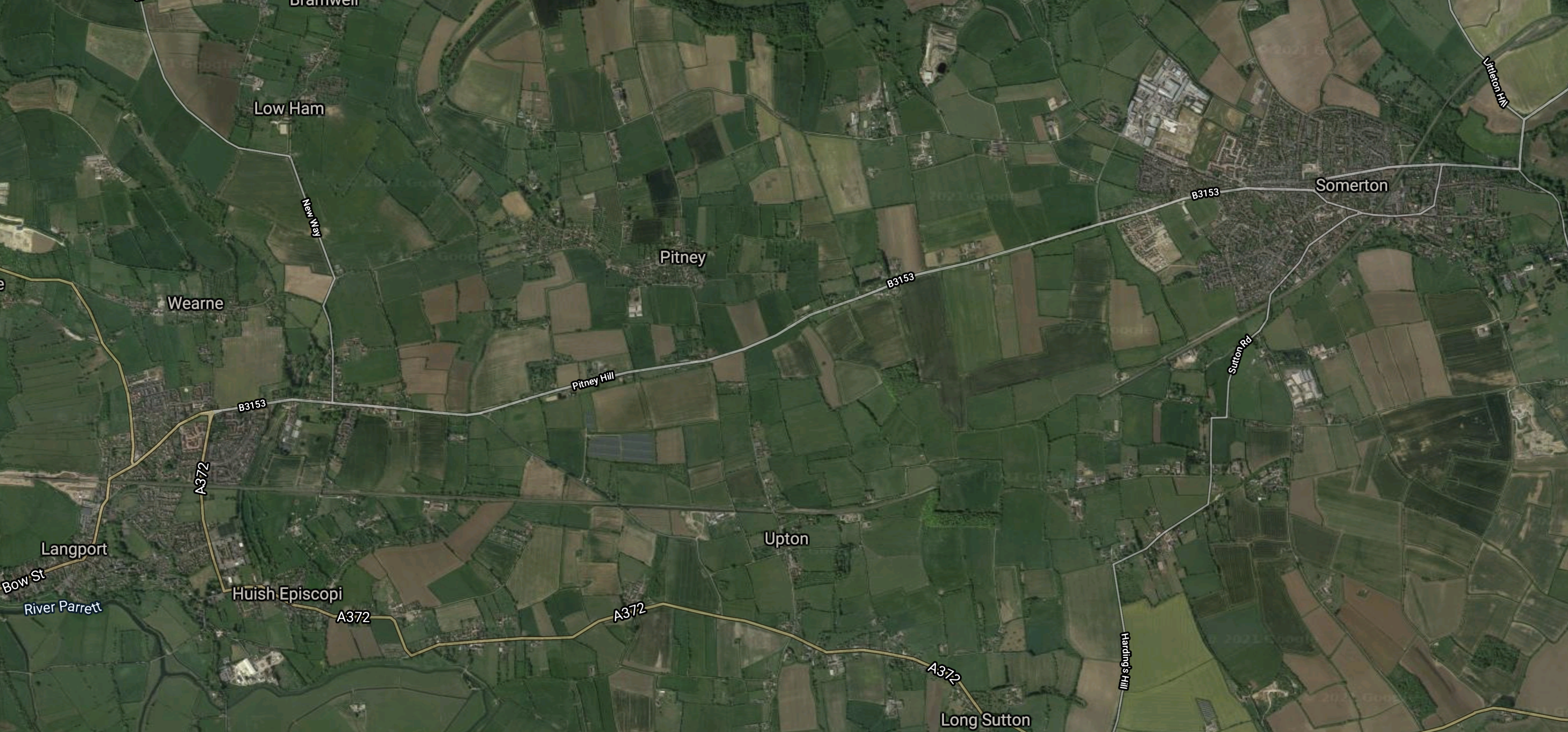
Note.
- Langport is in the South-West corner of the map.
- Somerton is in the North-East corner of the map.
- The Reading-Taunton Line goes through both villages, although both stations are now closed.
The map is probably best clicked to show on a larger scale.
This second Google Map shows the area between the two villages of Long Sutton and Pitney.
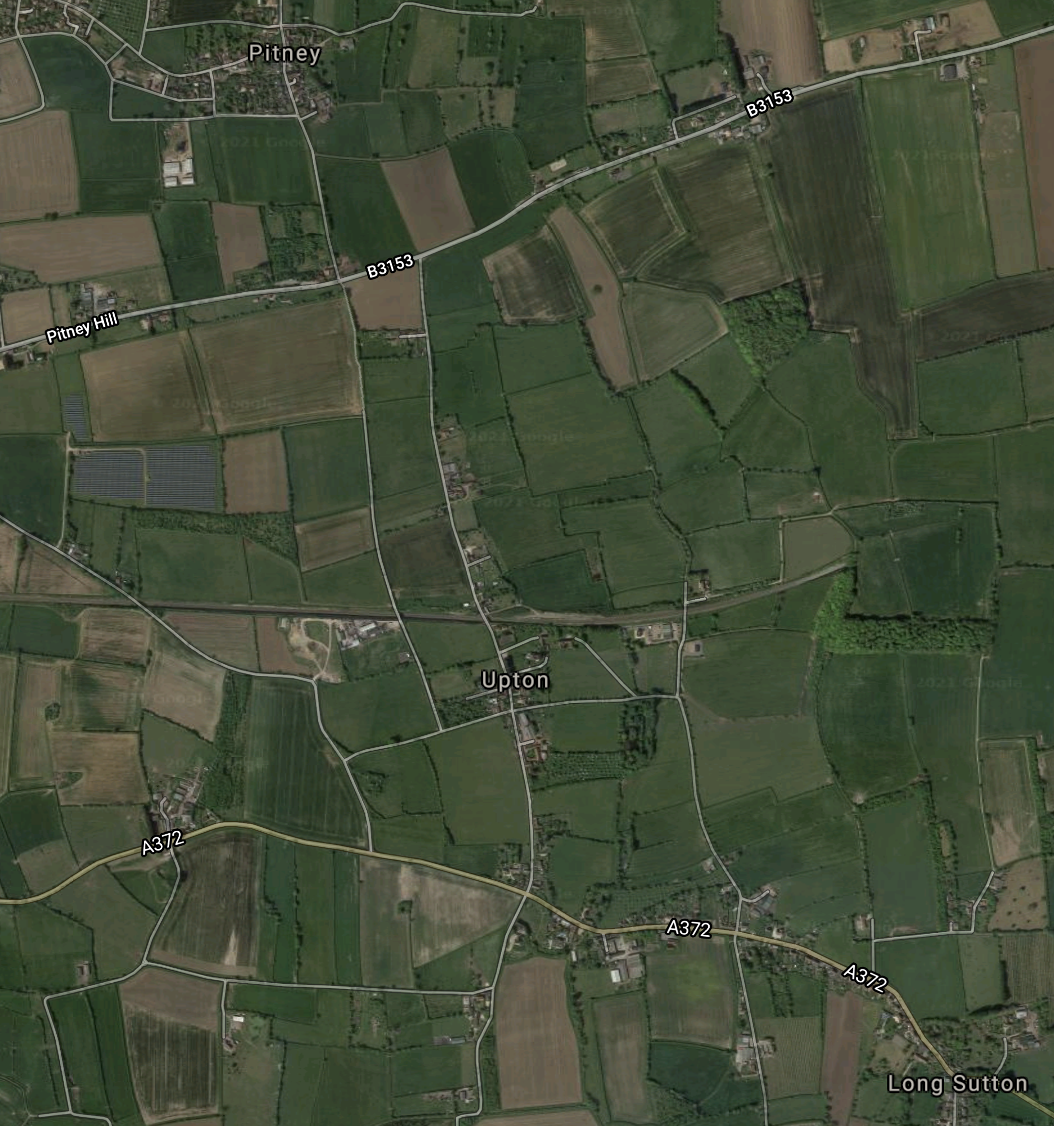
Note.
- Pitney is in the North-West corner of the map.
- Long Sutton is in the South-East corner of the map.
- The railway runs across the middle of the map it looks as if there was a station site to the North of the village of Upton.
- The only major road in the area; the A372, runs across the bottom of the map.
It is certainly a possibility for a Parkway station, but are the road connections good enough?
