Beeching Reversal – East Didsbury – Stockport
This is one of the Beeching Reversal projects that the Government and Network Rail are proposing to reverse some of the Beeching cuts.
This project has been puzzling me.
Search Google for “East Didsbury and Stockport Rail Link” and all you find is grandiose plans for billion pound extensions to the Manchester Metrolink.
Having researched a lot of the proposed Beeching Reversal projects, it appears to me, that the ones likely to be built, will give a lot of benefit for millions, not billions of pounds.
I just wonder, if in this project, Manchester is stealing an idea from Birmingham – the four-poster station!
This Google Map shows Smethwick Galton Bridge station.
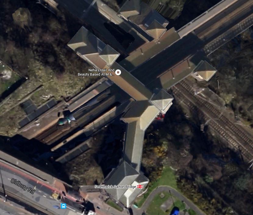
This extract from the Wikipedia entry, describes the station.
The station was opened in September 1995 as part of the Jewellery Line scheme to reopen the line between Smethwick and Birmingham Snow Hill station. It was built as an interchange station between two lines, and the platforms on both lines opened at the same time.
Note.
- The four lift towers with stairs, that connect the four platforms, have pyramid roofs.
- The station is fully step-free.
- The rail lines are at different levels.
These pictures show the station.
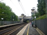
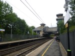

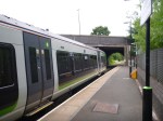
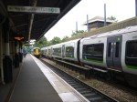


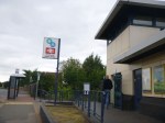


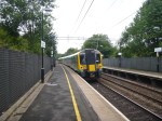
It is a very practical architectural idea and the world needs more four-poster stations to connect rail lines where they cross at different levels.
Could A Four-Poster Station Link East Didsbury And Stockport?
These are my thoughts.
The Location
This Google Map shows the general area, where the station could be built.
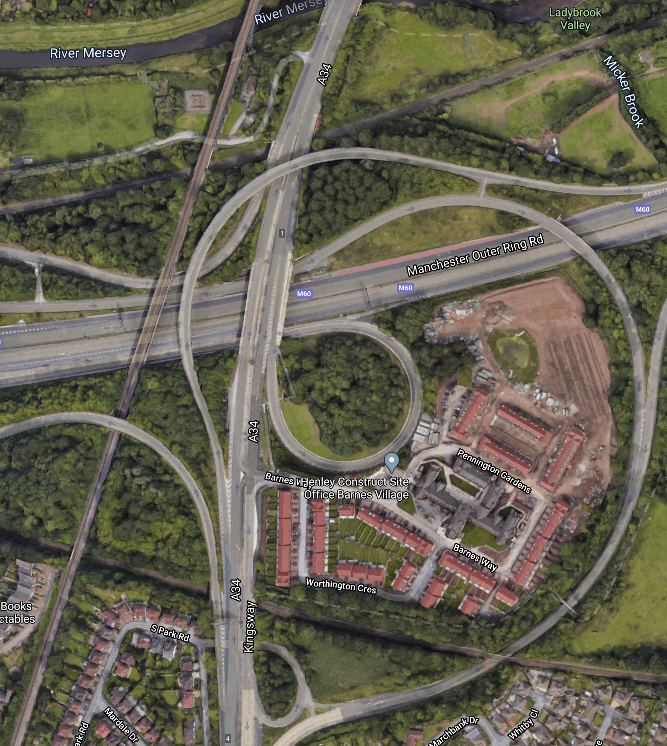
It is a spaghetti of motorways and rail lines with a lumpy sauce of new housing called Barnes Village in the middle.
Note, where the two rail lines cross in the South-West corner of the map.
This second Google Map, shows an enlarged image of the location, where the two rail lines cross.
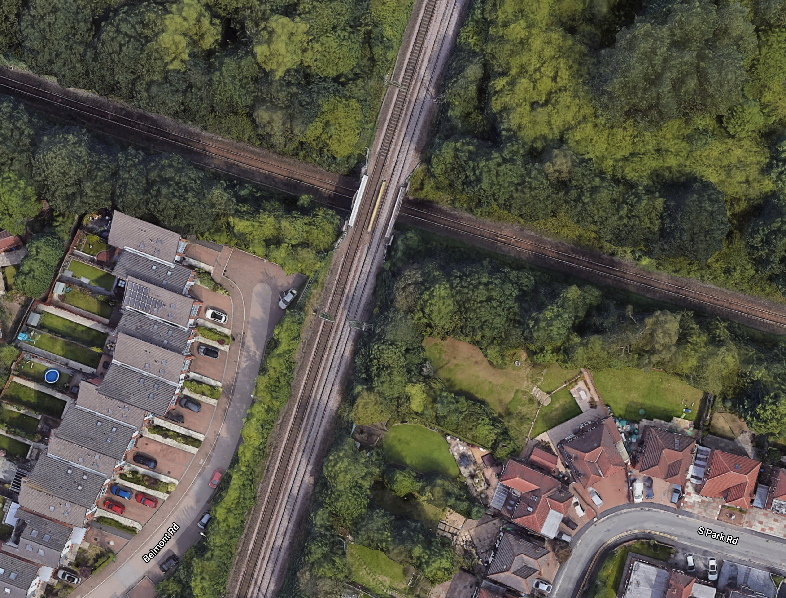
Note.
- The Styal Line runs North-South.
- The line running East-West is the Mid-Cheshire Line between Altrincham and Stockport stations.
I suspect most travellers joining the rail network at this point, would walk or cycle in from nearby locations or turn up in a taxi.
The Styal Line
The Styal Line has the following characteristics.
- It is an electrified double-track line.
- It connects Manchester Piccadilly and Wilmslow stations.
- There is a spur that serves Manchester Airport station.
- East Didsbury station, is the station North of where the two lines cross.
- Gatley station, is the station South of where the two lines cross.
- It is the route of trains to and from Manchester Airport.
These trains go through East Didsbury and Gatley stations in trains per hour (tph)
- 1 tph – Northern – Liverpool Lime Street and Crewe
- 1 tph – Northern – Liverpool Lime Street and Manchester Airport
- 1 tph – Northern – Manchester Airport and Blackpool North
- 1 tph – Northern – Manchester Airport and Cumbria
- 1 tph – Trains for Wales – Manchester Airport and Chester
- 1 tph – TransPennine Express – Manchester Airport and Redcar Central
- 1 tph – TransPennine Express – Manchester Airport and Newcastle
- 1 tph – TransPennine Express – Manchester Airport and Glasgow Central or Edinburgh
Freight trains also use the route.
This means that currently, there are eight tph between the Castlefield Corridor (Deansgate, Manchester Oxford Road and Manchester Piccadilly) and Manchester Airport, all of which go through the location, where the four-poster station could possibly be built.
So could the new station, be used to take pressure off the overloaded Castlefield Corridor?
The Mid-Cheshire Line
The Mid-Cheshire Line has the following characteristics.
- At this point it is a single-track without electrification.
- It connects Stockport and Altrincham stations.
Re-Doubling Of The Mid Cheshire Line Between Stockport and Altrincham And Associated Station Reopenings is another of the Beeching Reversal projects and envisages the following.
- Re-doubling the route.
- Possible electrification
- Reopening some stations.
This is the only passenger service that uses the route.
- 1 tph – Northern – Manchester Piccadilly and Chester
Up to two-three freight tph, also use the route.
In the related post, I said this about the desired frequency of services between Manchester and Chester stations.
It could be argued that two tph between Manchester Piccadilly and Chester are needed now and that four tph should be the preferred frequency.
There certainly needs to be four tph going through the proposed four-poster station.
Conclusion
I am being drawn to the conclusion, that this station if it were to be built, would help a lot of problems with Manchester’s railways.
- It would allow a sort out of train services to Manchester Airport.
- It would connect Stockport and Manchester Airport.
- It would connect Stockport and East Didsbury.
- It could help a solution to the problem of the Castlefield Corridor.
The station should be built.
Stevenage Station’s New Fifth Platform Opened A Year Early
The title of this post, is the same as that of this article on Rail Engineer.
This is the introductory paragraph.
A new £40 million platform and track at Stevenage station has been completed more than a year ahead of schedule.
Yesterday, it appears that the first scheduled train left Stevenage for Moorgate at 0502.
Will This Be Good For Travellers?
A few thoughts!
Stevenage Hospital
One of my old school friends lives in Cuffley. From that part of Hertfordshire, the hospital, patients use is in Stevenage. He can drive, but not everybody can!
LNER
Currently, LNER run an hourly service between Stevenage and Leeds, with an hourly service between Stevenage and Lincoln or York via Newark.
North From Enfield, Palmers Green, Southgate, Winchmore Hill and Wood Green
If you live in Enfield or the old London boroughs of Southgate or Wood Green, it could be easier to pick up trains for the North from Stevenage, rather than Kings Cross.
Not Bad For Me Too!
Even, where I live now, which is a mile or so East of Highbury & Islington station, if the timing is right, I can walk or get a bus for four stops to Essex Road station and get a train to Stevenage and then change for Leeds and the North.
East Coast Trains
East Coast Trains will be starting a fast, low-cost London Kings Cross and Edinburgh service, which will call at Stevenage.
Grand Central Trains
Grand Central Trains are currently shut down because of COVID-19, but will they call at Stevenage station, when they restart?
Hull Trains
Some Hull Trains services between London Kings Cross and Hull, call at Stevenage.
Hitachi’s Class 80x Trains
LNER, East Coast Trains and Hull Trains, all run versions of Hitachi’s Class 800 trains or similar.
These trains are built for performance and an extra stop at Stevenage station can probably be incorporated in the timetable without any penalty.
So will we see more trains stopping at Stevenage, if the train operators think it will be worthwhile?
Could Some Services From The North Terminate At Stevenage?
The Digswell Viaduct and the double-track section through Welwyn North station are the major bottleneck on the East Coast Main Line.
But a train returning North at Stevenage wouldn’t go over the viaduct.
Stevenage already has or could have excellent connections to the following.
- Cambridge, Stansted Airport and East Anglia
- Moorgate and the City of London and Crossrail.
- North East London
If keen pricing can encourage travellers to use Stevenage instead of Kings Cross, I can see operators wanting to run extra services, that could start at Stevenage.
I can also see Greater Anglia getting in on the act.
Could Greater Anglia’s Ipswich and Cambridge service be extended to Stevenage via the planned Cambridge South and Royston stations?
Could the service be timed to offer cross-platform interchange with their Norwich and Stansted Airport, at Cambridge South station?
Four important extra services would be created with a step-free interchange.
- Ipswich and Stansted Airport – 106 minutes – Step-free walk across at Cambridge South station
- Ipswich and Stevenage – 115 minutes – New direct service
- Norwich and Stansted Airport – 107 minutes – Existing service
- Norwich and Stevenage – 116 minutes – Step-free walk across at Cambridge South station.
A large number East Anglian rail journeys would be simpler.
Car Parking
Will there be enough car parking at Stevenage station?
I suppose, it would be possible to build a Stevenage Parkway station between Stevenage and Watton-at-Stone stations.
This Google Map shows the area.
Note, that the railway seems to mark the development limit for the town.
The high performance of the Class 717 trains, would probably mean, that there would be no lengthened journey times.
Conclusion
This project appears to have been well-thought through!
Beeching Reversal – Re-Doubling Of The Mid Cheshire Line Between Stockport and Altrincham And Associated Station Reopenings
This is one of the Beeching Reversal projects that the Government and Network Rail are proposing to reverse some of the Beeching cuts.
Much of this project appears to be about bringing the former Stockport, Timperley and Altrincham Junction Railway, back up to somewhere near its original state.
This map clipped from Wikipedia shows the railway.
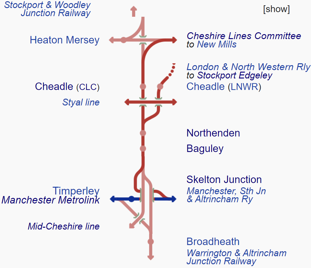
Note.
- Stockport Edgeley is now just Stockport station.
- Altrincham station is on the Mid-Cheshire Line.
- Baguley, Northenden and both Cheadle stations are now closed.
I have just flown my virtual helicopter between Stockport and Altrincham stations and much of the route is already double-track.
- At Cheadle Village Junction, which appears to be behind Cheadle Heath Police Station, the track becomes single.
- Just before Sharston Junction, which appears to be to the North-East of Sharston, the track becomes double again.
I estimate, that the single-track section is just over two miles long.
I was also able to ascertain, that there appeared to be plenty of space, where British Rail singled the track.
There is also a second section of single-track, through Navigation Road station, which is shown in this Google Map.
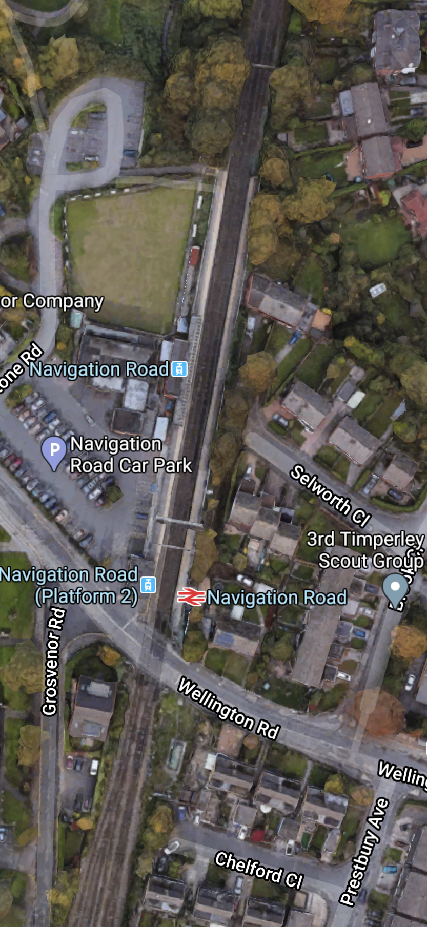
Note.
- Both tracks through Navigation Road station are bi-directional.
- The Metrolink track is on the West.
- The National Rail track is on the East.
- South of Navigation Road station, both Metrolink and National Rail get two tracks.
In the twenty-four hours to 0600 this morning, a total of seventeen freight movements, went through this section.
- Some were biomass trains between Liverpool and Drax power station, up to 6400 tonnes.
- Some were stone trains from the quarries in the Peak District.
- Some were Network Rail engineering trains.
I suspect this abort section of single track for both Metrolink and Network Rail is an absolute pain.
The single track must cause a lot of problems as the route is sometimes used by two or three trains per hour (tph) in both directions.
As some of the trains are some of the UK’s longest freight trains, it could also be very challenging for the signalling and the signallers.
Work That Could Be Done
These sub-projects could be performed.
Elimination of Single Track At Cheadle
I think this is essential and could greatly increase the capacity of the route.
This Youtube video from Don Coffey, shows the view from the cab, which travelling from Manchester to Chester. If you watch from about thirteen minutes, you’ll see the single-track section.
Sorting Out Navigation Road
As with the single-track section at Cheadle, I think this is essential and could greatly increase the capacity of the route.
Watch the same Youtube video from about twenty-two minutes, and you’ll see the single-track section, through Navigation Road station.
In Tram-Trains To Hale Station, I talked about the possibilities of using a variant of Class 399 tram-trains, similar to those running on the Sheffield Supertram.
Signalling
It could be there are minor adjustments or major work to get the most out of a double-track railway.
Electrification
This is an excerpt from the Wikipedia entry for the Mid-Cheshire Line.
In March 2015, the Electrification Task Force said that the Mid-Cheshire line was a tier 1 priority for being electrified in the CP6 period (2019-2024)
Would electrification be installed to perhaps run electric trains between Manchester Piccadilly and Chester?
Baguley Station
I covered Baguley station in Glazebrook Junction And Skelton Junction, where I said this.
Baguley station could be an interesting station, as it would be possible to create an interchange with the Manchester Metrolink. Wikipedia says this.
Proposals were made in the early 2000s to reopen a station in the Baguley area when the extension of the Metrolink out to Wythenshawe and Manchester Airport is actioned. In May 2011 re-opening of the station on the Stockport-Altrincham line was included in Transport for Greater Manchester’s Passenger Plan. The station would be on Southmoor Road and would be a tram/train interchange with the Baguley tram stop, which opened in 2014.
This Google Map shows the possible Baguley Interchange.
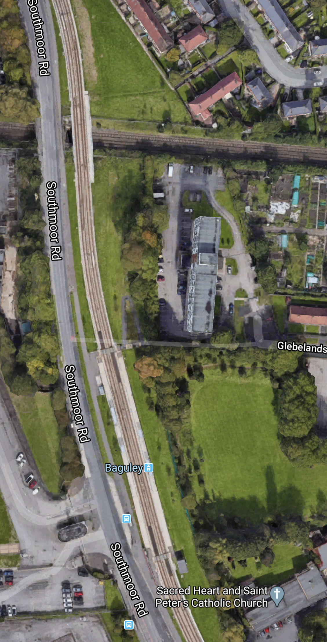
Note.
-
- The North-South road is Southmoor Road.
- The Metrolink branch to the Airport runs alongside.
- The Stockport and Altrincham Line crosses East-West towards the North of the map.
If you take a train between Manchester Piccadilly and Chester via Stockport, Navigation Road, Altrincham and Knutsford, you cross on the railway through here.
So perhaps a Baguley Interchange station, would help some people get to and from Manchester Airport?
Baguley station certainly has possibilities.
Cheadle North Station
Could Cheadle North station be replaced?
This article on the Manchester Evening News is entitled Cheadle ‘On Cusp’ Of Having Own Railway Station For First Time Since Mid-1960s, where this is said.
If ministers back the proposals, the railway station is likely to be built next to the Alexandra Hospital along the mid-Cheshire line – close to where the original Cheadle (later Cheadle North) station was.
This Google Map shows the Cheadle Alexandra Hospital and the Mid-Cheshire Line.
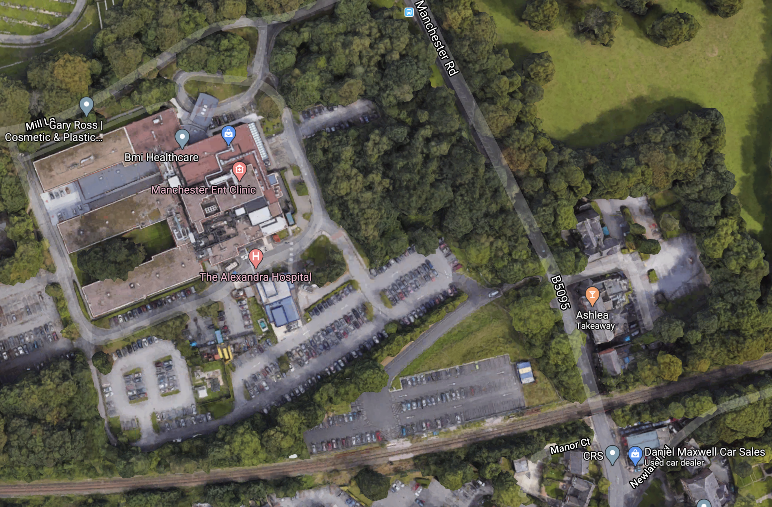
Note.
- The hospital is the largest private hospital in the UK, outside London.
- The railway, which is single-track at this point, runs along the South side of the site.
If the line is double-tracked, as seems likely, adding a small station would not be a challenging addition.
Northenden Station
Could Northenden station be replaced?
Future Train Services
The train service between Manchester Piccadilly and Chester is as follows.
- The service is 45 miles.
- It takes 90 minutes.
- There are stops at Stockport, Navigation Road, Altrincham, Hale, Ashley, Mobberley, Knutsford, Plumley, Lostock Gtalam, Northwich, Greenbank, Cuddington, Delamere and Mouldsworth.
It could be argued that two tph between Manchester Piccadilly and Chester are needed now and that four tph should be the preferred frequency.
There are other services.
Conclusion
After restoring the double-track on this route, there are possibilities to spend, as much money as you want.
In Tram-Trains To Hale Station, these were my conclusions.
- Tram-trains can deliver a capacity improvement through Navigation Road station.
- Tram-trains could be extensively tested on the existing Manchester Metrolink network.
- Tram-trains could be used to build a simple extension to Hale station from Altrincham.
- The Manchester and Chester service via Stockport, Navigation Road and Altrincham stations could be run by tram-trains.
A comprehensive network of tram-trains could be developed between, through and beyond Altrincham, Crewe and Chester.
Cheshire would have a quality commuter and local train network into Manchester.
After all in the next couple of years, Merseyrail’s Cheshire network will be getting a major upgrade with new trains and perhaps another new route.
Beeching Reversal – Glazebrook Junction And Skelton Junction
This is one of the Beeching Reversal projects that the Government and Network Rail are proposing to reverse some of the Beeching cuts.
This Wikipedia entry, which is entitled Glazebrook East Junction–Skelton Junction Line. gives a lot of information.
Closure Of Passenger Services
This is said.
As part of the London Midland region of BR, It remained a busy line with trains from Liverpool Central and Warrington Central up until the mid-1960s. It was only on the withdrawal of these stopping passenger services in 1964 that all the stations closed along the line.
Where did the services terminate?
I would assume it was Stockport.
Closure Of Freight Services
This is said.
The line carried on as freight only until 1983 when Cadishead Viaduct was in need of serious and costly repair. British Rail decided rather than repairing the viaduct to close it and mothball the line. The tracks were lifted in the mid-1980s from Glazebrook to Partington.
This Google Map shows Cadishead Viaduct over the Manchester Ship Canal, which appears to need some TLC.
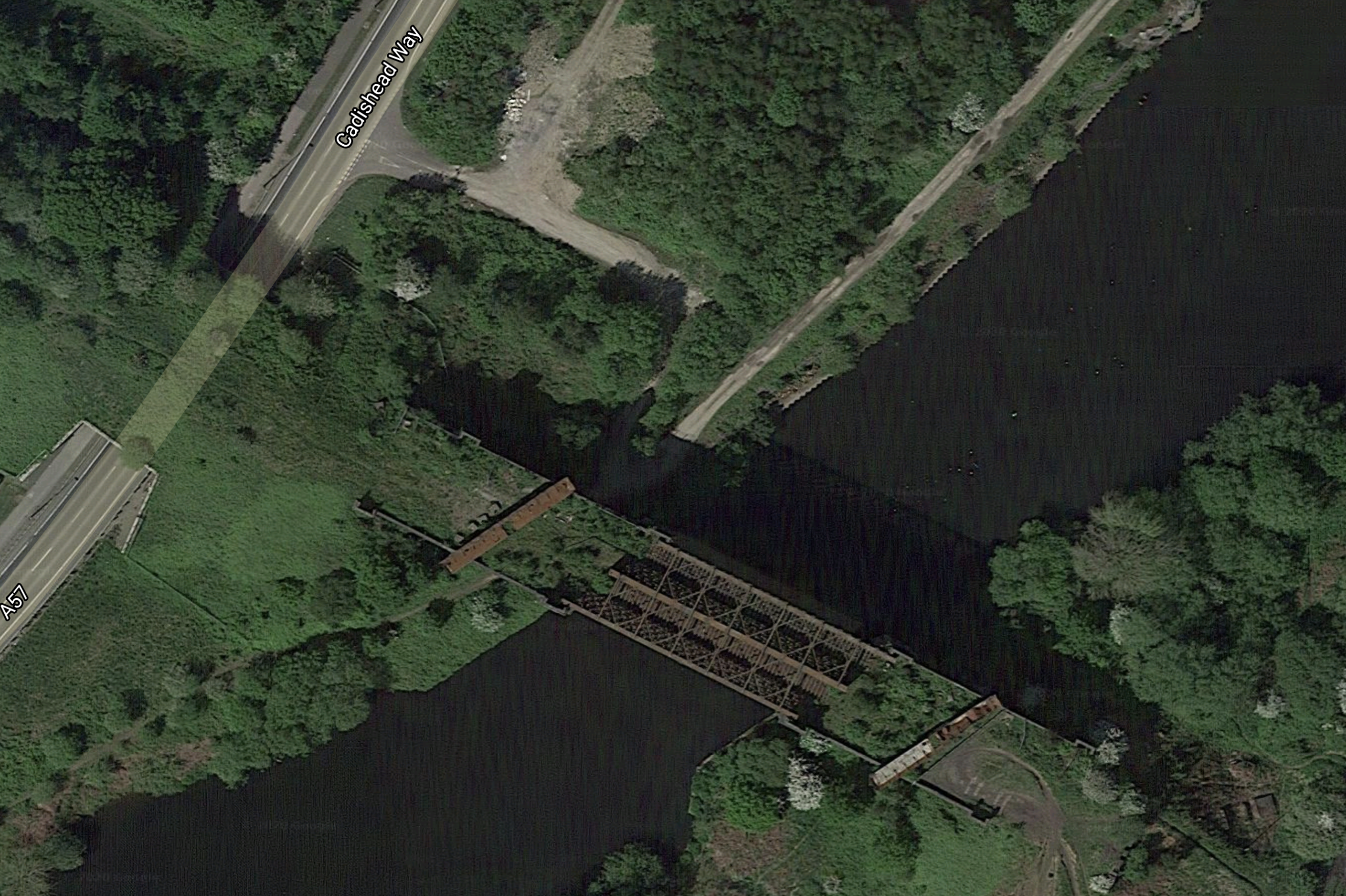
It looks to be in similar condition to that of this bridge at Tottenham Hale station in London, before it was replaced.
This Google Map show the bridge at Tottenham Hale now.
It certainly looks a lot better and was installed in a few days over Christmas.
It might be expensive but it certainly looks possible, to add a pair of replacements at Cadishead Viaduct.
Glazebrook Junction
This is said about Glazebrook Junction.
As of 2010 Glazebrook East Junction is still intact and remains part of the national network. The junction towards Cadishead on the original deviation is also still in place with a powered signal lamp showing a permanent red signal. This short section of track from the still live passing loop at Glazebrook East Junction towards Cadishead on the original non-deviated line is permanently point locked. The short section ends near a barrow crossing shortly before a bridge carrying a bridleway above.
This Google Map shows the Junction and Glazebrook station.
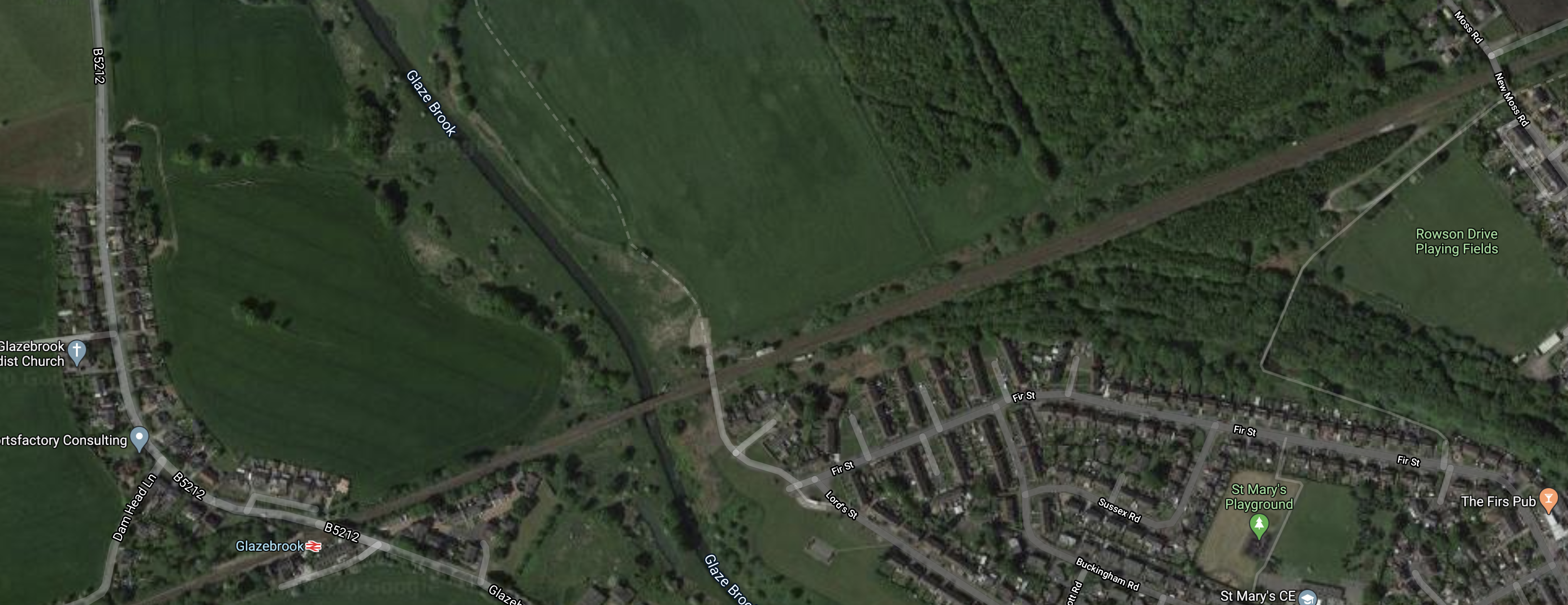
Note.
- Glazebrook station is in the South-West corner of the map.
- The line to be reinstated leaves the map in the South-East corner.
Could there be space for a double-track junction?
Skelton Junction
This is said about Skelton junction.
The tracks from Skelton Junction to the south east of Partington were left and remained intact for chemical trains for a local chemical plant. These trains continued to use this route until 10 October 1993. To this day however this part of the line is intact but disused; the signal lamps at Skelton Junction remain powered red. Also in 2005 this part of the track saw some work; vegetation clearance took place for the line to reopen for freight but this fell through.
This Google Map shows Skelton junction.
Note, that from Skelton junction it appears, it is an easy run to Stockport station.
Stations
Four stations from the route have closed.
Baguley station could be an interesting station, as it would be possible to create an interchange with the Manchester Metrolink. Wikipedia says this.
Proposals were made in the early 2000s to reopen a station in the Baguley area when the extension of the Metrolink out to Wythenshawe and Manchester Airport is actioned. In May 2011 re-opening of the station on the Stockport-Altrincham line was included in Transport for Greater Manchester’s Passenger Plan. The station would be on Southmoor Road and would be a tram/train interchange with the Baguley tram stop, which opened in 2014.
This Google Map shows the possible Baguley Interchange.
Note.
- The North-South road is Southmoor Road.
- The Metrolink branch to the Airport runs alongside.
- The Stockport and Altrincham Line crosses East-West towards the North of the map.
If you take a train between Manchester Piccadilly and Chester via Stockport, Navigation Road, Altrincham and Knutsford, you cross on the railway through here.
So perhaps a Baguley Interchange station, would help some people get to and from Manchester Airport?
Future Train Services
It would appear that at the simplest level it creates a passenger connection between Liverpool Lime Street and Manchester Piccadilly stations via South West Manchester and Stockport.
There are also large projects underway, close to Glazebrook.
Climate Emission Killer: Construction Begins On World’s Biggest Liquid Air Battery
railfuture On The Castlefield Problem
Will these two projects and others like them by the Manchester Ship Canal, create the need for more passenger and freight trains to the area?
Conclusion
It looks to me, that opening this new passenger train route could be very beneficial for those that live, work and play in the area.
Beeching Reversal – Reinstating Beeston Castle And Tarporley Station
This is one of the Beeching Reversal projects that the Government and Network Rail are proposing to reverse some of the Beeching cuts.
Beeston Castle and Tarporley station was on the Crewe and Chester Line.
- The station was closed in 1966.
- The station was situated almost exactly half-way between Crewe and Chester stations.
- If it were to be reinstated, Beeston Castle and Tarporley would be the only intermediate station.
- Wikipedia says reinstatement will cost £3 million.
This Google Map shows the site of the station.
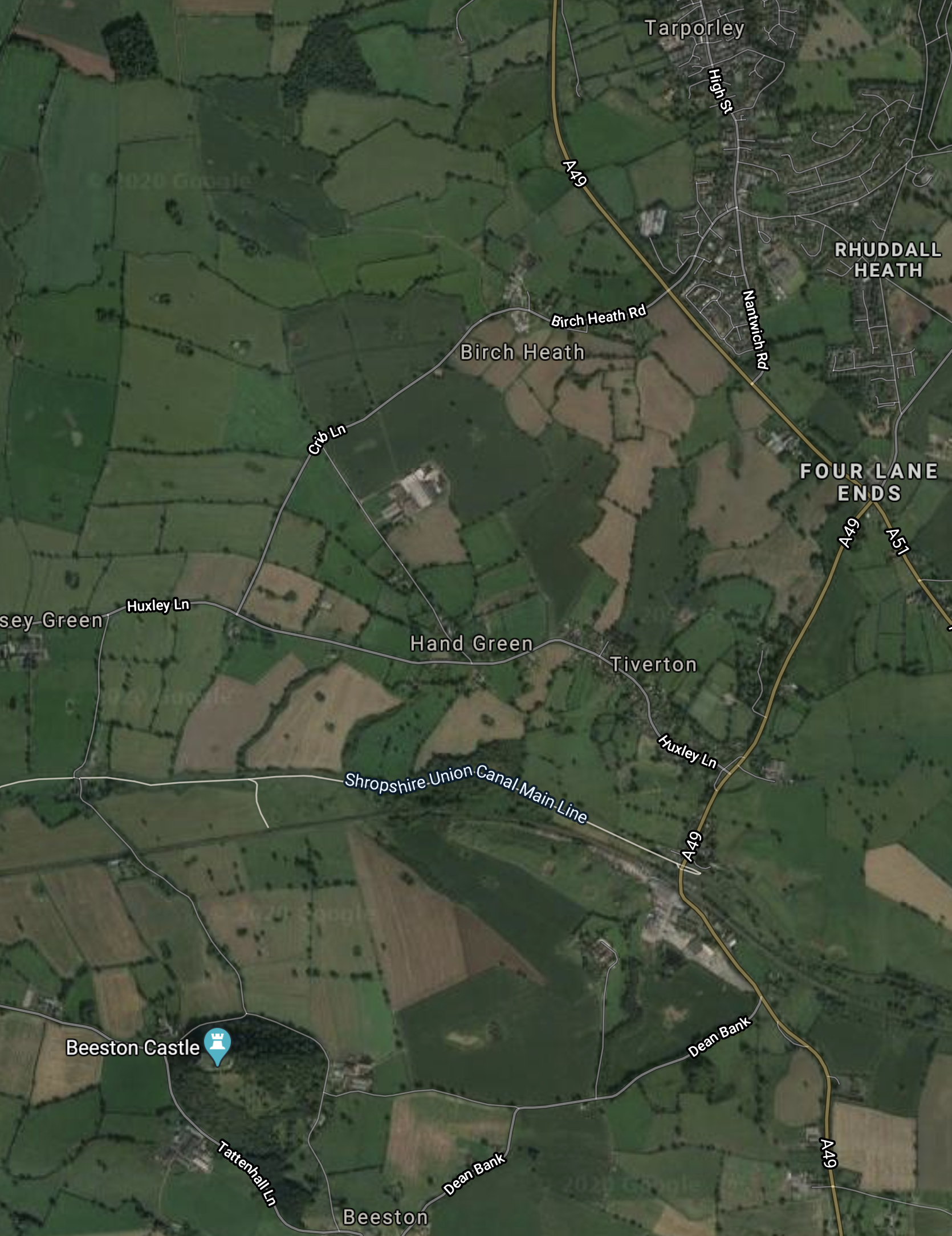
Note, that the station appeared to have been, where the A49 crosses the railway and the Shropshire Union Canal.
This Google Map shows an enlargement of the site.
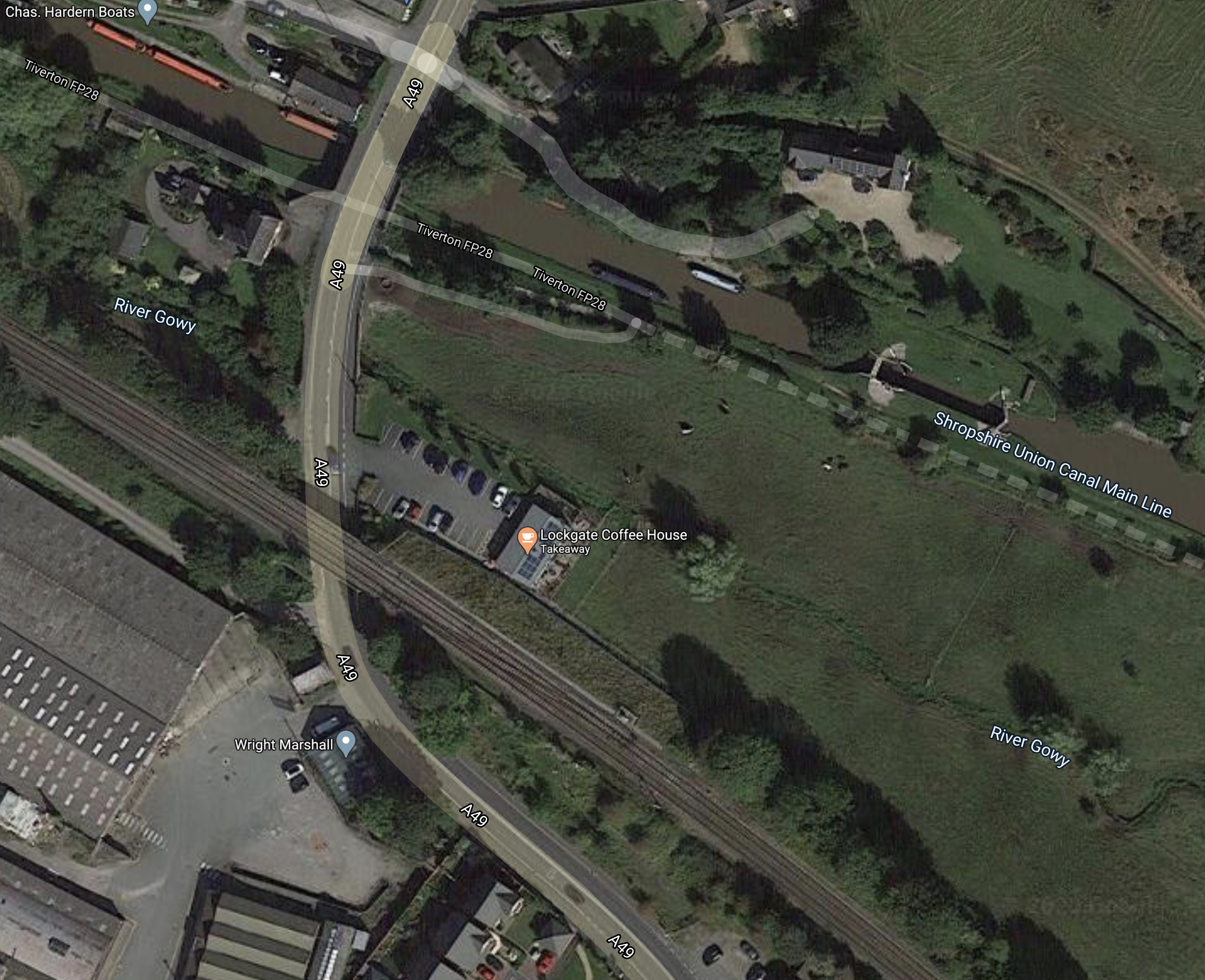
Note.
- If canal boats are for hire in the North-West corner of the map, someone will like a convenient station.
- The former platforms are just about visible.
- Is there enough space for the required car parking?
There’s even a handy cafe for the builders.
Conclusion
It doesn’t appear to be the most challenging station to reinstate.
Beeching Reversal – Reopening Wymondham-Dereham Line
This is one of the Beeching Reversal projects that the Government and Network Rail are proposing to reverse some of the Beeching cuts.
It has looked to me, that for some years, that those in Norfolk’s rail industry and Local Government, have been co-operating with rail problems and developments in the county.
If you read the Wikipedia entry for the Mid-Norfolk Railway, various activities are revealed.
- Regular steam and diesel services between Wymondham and Dereham stations.
- Occasional sightseeing services North of Dereham station.
- Mid-Norfolk Railway facilitates commercial freight trains.
- Dereham yard has been used as a servicing depot by Direct Rail Services for over ten years.
- Network Rail store track plant at Dereham.
- There are facilities to transfer damaged rail vehicles to road vehicles at Dereham.
- The Army uses the line to transport vehicles by train.
- Storage of trains for Greater Anglia, who have a chronic lack of space.
- The line appears to be used for specialist crew and driver training.
- In Mid Norfolk Railway Completes Work On ‘First For UK’ Railway Level Crossing, I wrote about how the railway company used new Dutch technology to demonstrate how to rebuild a level crossing.
It seems, that if you have a different rail-related need in Norfolk, that the Mid-Norfolk Railway will at least listen to your needs.
The company and volunteers have the ambition to restore the railway as far as Fakenham, which will make it one of the longest heritage railways in England.
I am not surprised that reopening services between Wymondham and Dereham stations, is on the list of Beeching Reversal projects.
Dereham
Dereham is a market town of 18,600 residents.
This Google Map shows the Dereham station complex.
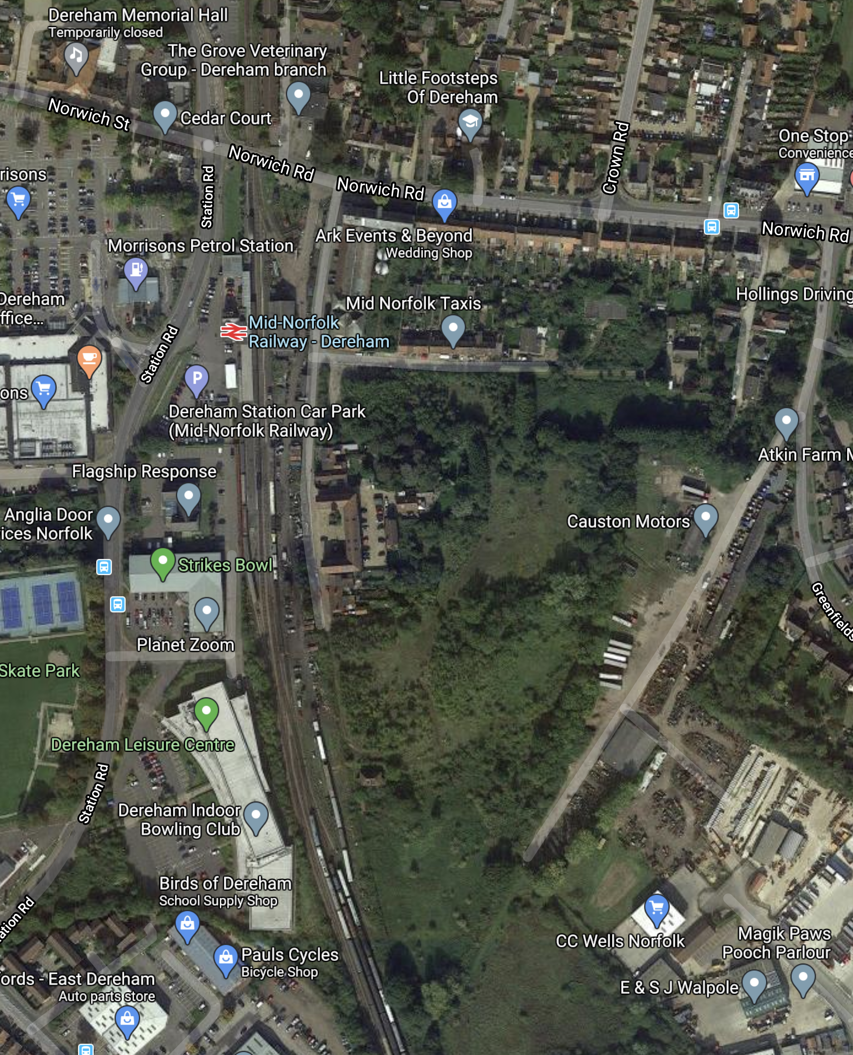
It is the headquarters of the Mid-Norfolk Railway.
Wymondham
Wymondham is a developing market town of 14,400 residents, that has a station on the Breckland Line between Cambridge and Norwich via Ely and Thetford.
The Mid-Norfolk Railway also has a connection to the Breckland Line and access to Wymondham station at Wymondham South junction.
This Google Map shows the town of Wymondham.
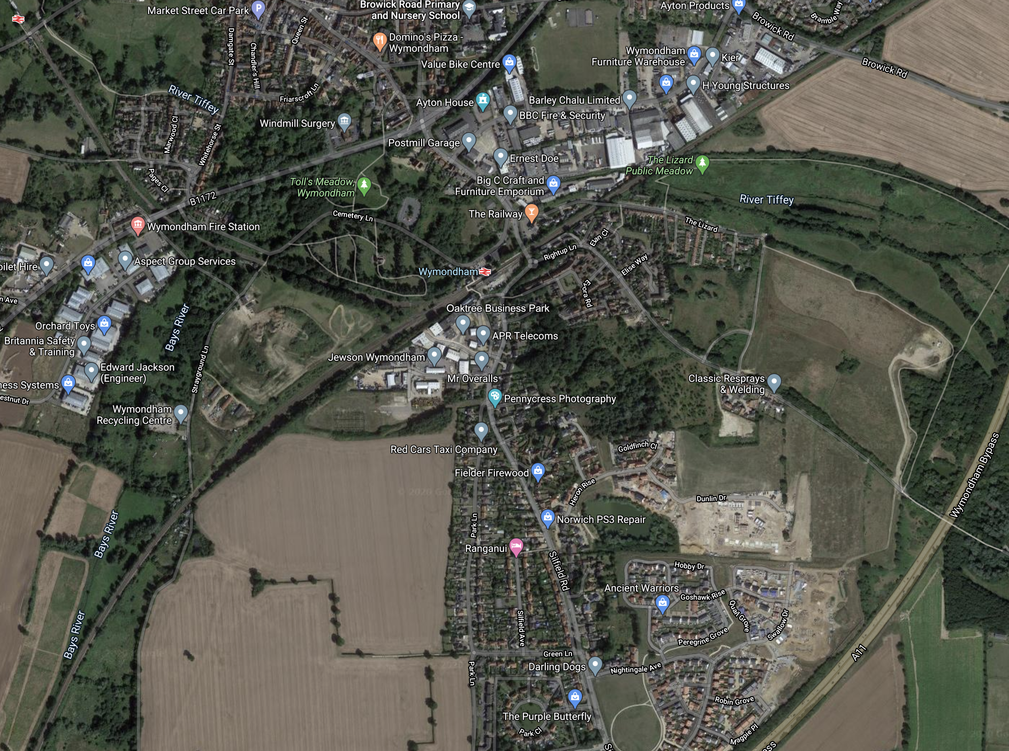
Note.
- The Breckland Line going SW-NE across the map.
- Wymondham station in the middle of the map.
- Wymondham Abbey station, which is on the Mid-Norfolk Railway in the North-West corner of the map.
- Wymondham South junction, where the branch divides to the South-West of Wymondham station.
The A11 Wymondham Bypass encloses a lot of land, which seems to be being developed into housing.
Breckland Line Train Services
Current train services on the Breckland Line include.
- Greater Anglia – One train per hour (tph) – Norwich and Stansted Airport via Cambridge
- East Midlands Railway – One tph – Norwich and Liverpool via Ely and Peterborough
Note.
- Both train franchises are Abellio.
- Both train franchises use modern diesel or bi-mode trains.
As there is significant development of housing and industry, all along the A11 and the Breckland Line between Cambridge and Norwich, many believe that there is a large opportunity for the growth of passenger train services.
All being well in a few years, Norwich will get a third service in a one tp2h service along the East West Railway to Oxford.
But towns like Wymondham probably will need better and more connections to Cambridge and Norwich, before that, as although the roads are good, the emissions won’t be!
The Trowse Swing Bridge
The single-track Trowse Swing Bridge is a major bottleneck on any service between Norwich and the South.
It does manage to carry up to nine to ten tph, but it appears that for efficient operation of extra services South from Norwich, that the bridge will have to be replaced or by-passed.
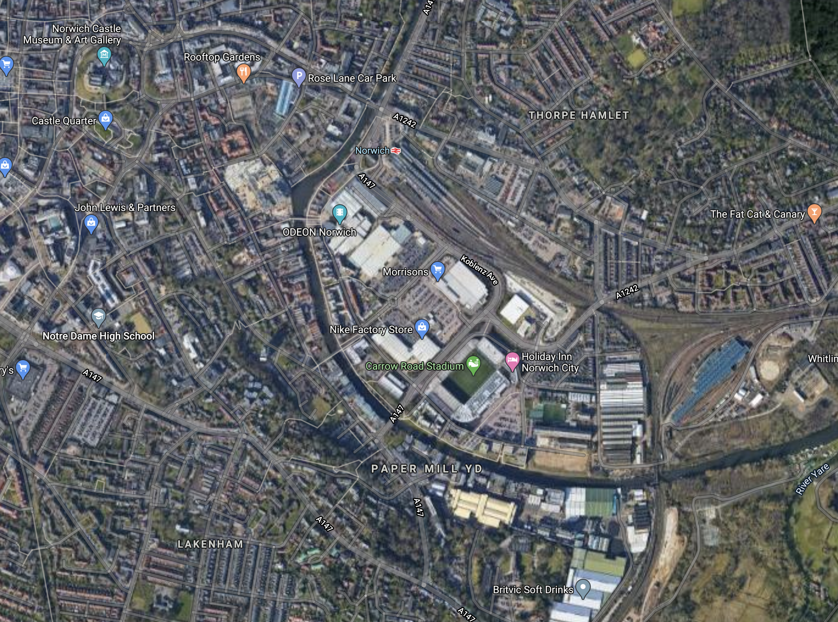
This Google Map shows Trowse Bridge.
When the Great Eastern Main Line was being electrified to Norwich station, a temporary station was built in this area, whilst electrification was added to the bridge.
A Station At Trowse
A similar strategy could be used, whilst the bridge is replaced, but I suspect, that a bolder plan might be possible.
- There is a lot of development going on in Norwich.
- It is expected that rail traffic South from Norwich to Cambridge and London will grow significantly in the next few years.
- Removing the requirement for the bridge to open, would require difficult Parliamentary legislation.
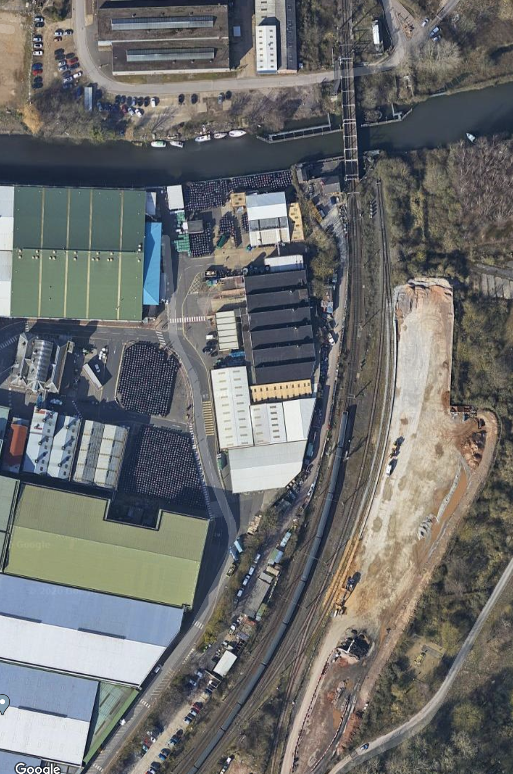
This Google Map shows the wider City Centre.
Note.
- The River Wensum curving through the City.
- The large Norwich station in the middle of the map.
- Norwich City Centre to the West of the station.
- Norwich City’s Carrow Road ground to the South of the station.
- The blue-roofed Norwich Crown Point Depot towards the East of the map.
- Trowse bridge crossing the river to the South of Crown Point Depot.
It should also be noted, that to solve some of the chronic overcrowding in Crown Point Depot, Greater Anglia have developed some new sidings South of the Trowse bridge, on the Western side of the Great Eastern Main Line, around the area of the former Trowse station.
Consider.
- If you look at the rail lines South of the Trowse bridge, the Breckland Line crosses under the Great Eastern Main Line and then joins the main line from the East.
- Norwich could borrow an idea from other cities like Bristol and run a water bus on the River Wensum.
- The South Bank of the river looks ripe for development.
I wonder if it would be possible to reopen Trowse station as a modern riverside station.
- There would be two electrified through platforms.
- The Southern ends of the through platforms would connect to the Great Eastern Main Line and the Breckland Line, as they do now.
- The Northern ends of the through platforms would combine and cross the Trowse Bridge, as they do now.
- On the Eastern side of the station, there would be up to two electrified bay platforms, which could connect to any route to the South.
- At least one platform would be able to take a full-length Class 745 train.
- There would be a river bus station, with connections to the main Norwich station, Carrow Road and Norwich City Centre.
- The station would be fully step-free.
As the infamous bridge is only thirty-three years old, surely it can be refurbished and modernised, so that the major problem of reliability is eliminated.
This new station would give train operators advantages and options.
- The station would be very handy for office and residential developments along the river.
- The rail line into Norwich could probably be kept open during the construction, as the bridge is only being refurbished.
- Some travellers to and from Norwich might prefer to use Trowse, rather than Norwich station and use the water bus.
- Extra services to Norwich might terminate in the bay platforms at Trowse and would not need capacity on the bridge.
- I suspect that a four or five tph frequency would operate between Norwich and Trowse station.
- In times of disruption, the bay platforms can be used to turn trains South of the bridge.
I’m sure there is an innovative solution in there somewhere.
What is Norwich City Council intending to do along the South bank of the river?
Future Train Services Between Norwich And The South
Greater Anglia have bought a lot of new trains and I doubt, that they’ll be leaving them in sidings, if they have a job for them to do.
I can certainly see four tph Turn-Up-And-Go services running on the following routes around Norwich.
- Norwich and Cambridge
- Norwich and Ipswich
- Norwich and Lowestoft
- Norwich and Yarmouth
Being able to turn some Cambridge and Ipswich trains South of Trowse bridge, may be the better solution, than replacing, rather than refurbishing the bridge.
Norwich And Dereham
- Norwich and Dereham stations are just over twenty miles apart and I suspect that Class 755 trains can do the trip in about twenty-five minutes.
- This may open up the possibility of an hour’s round trip between Trowse and Dereham stations.
If the hour trip is possible, this could open up a two tph service, run by just two trains.
A Possible Timetable
I could see something like this being a possible timetable.
- East West Rail – One tph – Norwich and Oxford via Cambridge
- Greater Anglia – One tph – Norwich and Stansted Airport via Cambridge
- Greater Anglia – One tph – Trowse and Stansted Airport via Cambridge
- Greater Anglia – One tph – Trowse and Cambridge
- Greater Anglia – Two tph – Trowse and Dereham
- East Midlands Railway – One tph – Norwich and Liverpool via Ely and Peterborough
- Greater Anglia – Two tph – Norwich and London Liverpool Street via Ipswich
- Greater Anglia – One tph – Trowse and London Liverpool Street via Ipswich
- Greater Anglia – One tph – Trowse and Ipswich
Trowse bridge would be handling five tph in both directions, with six tph terminating in Trowse station.
Obviously, there are a lot of permutations and combinations, that will be determined by customer forecasts and figures.
Conclusion
I’ve thought the route between Norwich and Dereham stations will be a commuter, shopping and leisure rail route for some time.
As I indicate, I think some work will need to be done at the Trowse bridge, but a two tph service should be possible.
Beeching Reversal – Mid-Cornwall Metro
This is one of the Beeching Reversal projects that the Government and Network Rail are proposing to reverse some of the Beeching cuts.
This is a strange project, as I can’t find a detailed description of what it entails.
All I can think, is that it is a general project to run all the local lines in Cornwall as a unified whole.
Great Western Railway runs these services in Cornwall.
- Cornish Main Line – London Paddington and Penzance – One train per two hours (tp2h) – Calling at Plymouth, Liskeard, Bodmin Parkway, Lostwithiel, Par, St Austell, Truro, Redruth, Camborne and St Erth
- Cornish Main Line – Exeter St. Davids and Penzance – One train per hour (tph) – Calling at Newton Abbot, Totnes, Ivybridge, Plymouth, Devonport, Dockyard, Keyham, St Budeaux Ferry Road, Saltash, St Germans, Menheniot, Liskeard, Bodmin Parkway, Lostwithiel, Par, St Austell, Truro, Redruth, Camborne, Hayle and St Erth
- Looe Valley Line – Liskeard and Looe – One tph – Calling at Coombe Junction Halt, St Keyne Wishing, Well Halt, Causeland and Sandplace.
- Atlantic Coast Line – Par and Newquay – One tp2h – Calling at Luxulyan, Bugle, Roche, St Columb Road and Quintrell Downs
- Maritime Line – Truro and Falmouth Docks – Two tph – Calling at Perranwell (1tph), Penryn, Penmere and Falmouth Town
- St. Ives Bay Line – St. Erth and St. Ives – Two tph – Calling at Lelant Saltings, Lelant and Carbis Bay
Could frequencies and connectivities be improved?
Other Beeching Reversal projects are also aiming to improve the railways in Cornwall.
Transforming the Newquay Line
Reinstatement of Bodmin-Wadebridge Railway and associated works
Increased service provision Bodmin General-Bodmin Parkway
I think the first might increase frequencies on the Newquay to one tph or even two tph and the Bodmin General station improvements should create a useful new platform.
Wikipedia mentions this project.
Reopening The Lostwithiel And Fowey Railway To Passengers
Are there any other lines, stations or platforms, that could be reopened, given a passenger service or or an increase in frequency?
Conclusion
Someone must have a plan somewhere! So can they please disclose it?
Beeching Reversal – Light Railway Extension To The Barnstaple Branch (Chivenor Braunton) “TawLink”
This is one of the Beeching Reversal projects that the Government and Network Rail are proposing to reverse some of the Beeching cuts.
This is an unusual project for two reasons.
- It is based on light railway or tram technology.
- The case for the extension is fully set out in the Taw Link web site.
None of the other projects, that I have documented have such a comprehensive statement of their case for acceptance.
The Introduction
This is taken from the home page of their web site.
Combe Rail CIO is proposing a modern, light railway between Barnstaple and Braunton. The North Devon Local Plan already urges the protection of former railway routes, to allow for future re-instatement. This former railway route is 98% intact, with sufficient width to accommodate a new single-track railway line alongside the Tarka Trail and South West Coast Path.
It’s now accepted that new and re-opened railways unlock economic growth. The success of the Borders Railway in Scotland is a spectacular example of this. The challenge of North Devon’s ever-growing population demands similar, forward-looking infrastructure planning.
Some of the other projects, that I have documented, could do with such a clear Statement of Intent.
The Route
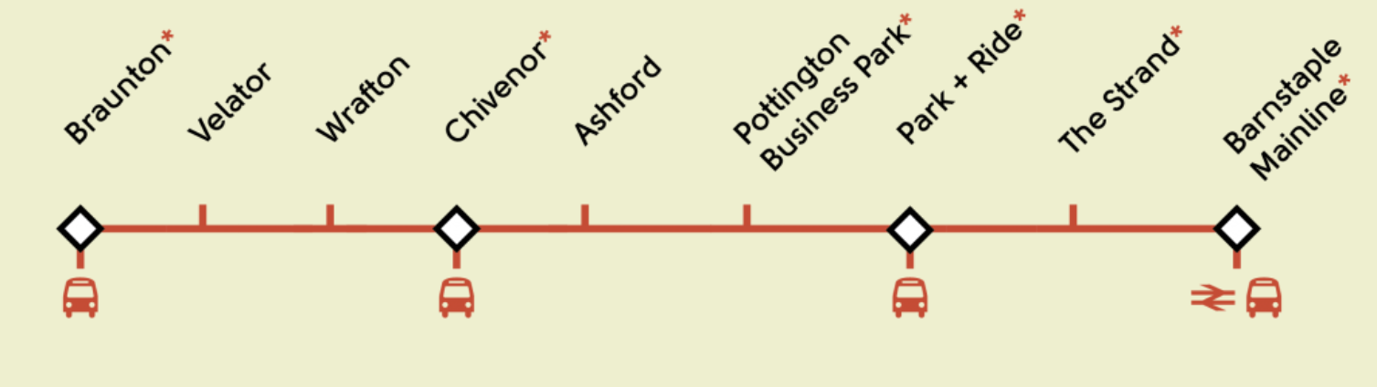
This graphic from the Route page on web site shows the route.
And this Google Map shows the area.
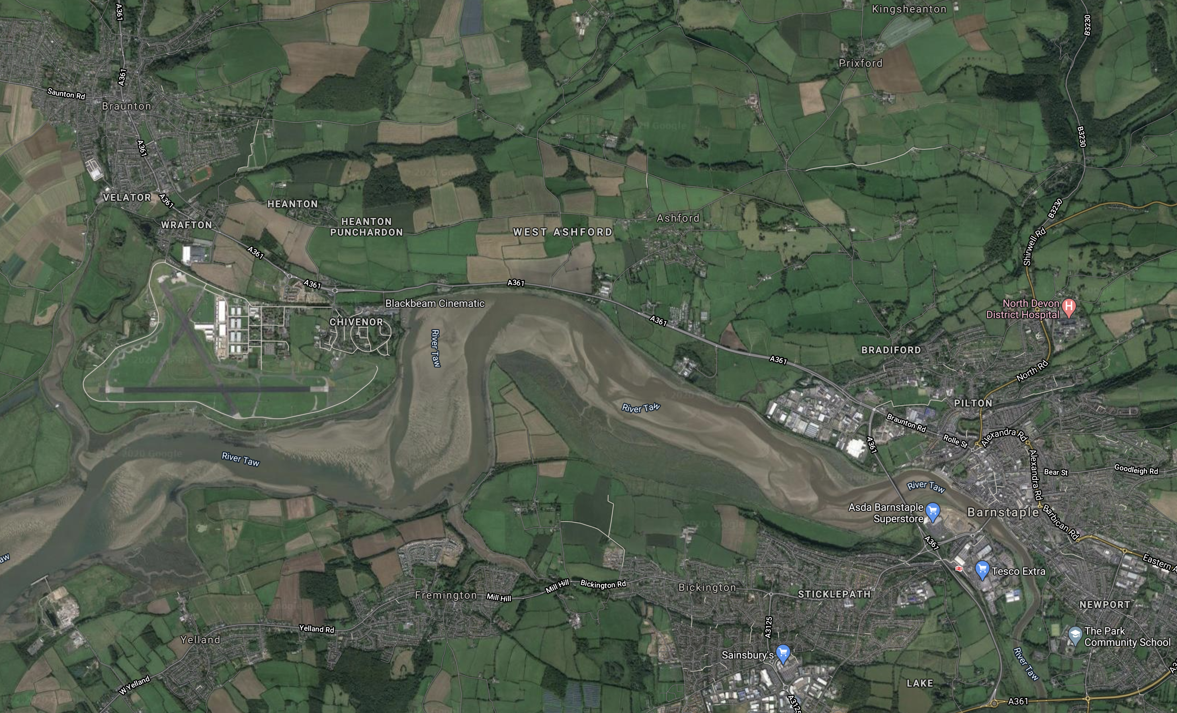
Note.
- Braunton is in the North-West corner of the map.
- Barstaple is in the South-East corner of the map.
- The River Taw runs East-West across the map.
- The runways of the former RAF Chivenor, which is now a Royal Marine Base, can be found.
If you enlarge the map by clicking on it, many of the stations on the TawLink can be picked out.
This paragraph from the Route page describes the route.
Starting from Caen Street in Braunton, it will run tramway-style along Station Road, and then use the old railway formation all the way to the Civic Centre car park in Barnstaple. It will then street-run past the front of the former Town Station and along Castle Street to The Strand in the heart of Barnstaple. There are two options for crossing the river Taw – either to street-run along Long Bridge, or to share the proposed reinstated (former railway) bridge. The line will then street-run along Stickelpath Terrace to re-connect to the National Rail Network at Barnstaple (Mainline.) Intermediate stations will be provided at Velator, Wrafton (for Perrigo), Chivenor (Business Park and The Landings), Ashford (Garden Centre and Braunton Inn) Pottington (Business Park) and Barnstaple Park-and-Ride (near the A39 downstream bridge – which could potentially have a huge catchment area.)
As the proposals for the Reinstatement Of The Bodmin-Wadebridge Railway, are doing, these proposals are replacing a walking and cycle path with a walking/cycling/single-track rail route.
This pair of South-West proposals could set an important design precedent, that can be applied in other places across the UK.
Are These Two Routes Substantially Level?
Thinking about this similar design, were the two original rail routes built as level as possible, so they are now easy walking and cycling routes?
I suspect, that there’s only a couple of metres difference between the two ends of this route at Barnstaple. So it could be the case here!
If thar is the case, it would mean that less energy would be needed to travel the route!
The Trams
This paragraph from the Trams page on the web site describes the trams.
This will be a modern community- and commuter railway, which will run throughout the year. Its scenic location will also make it highly attractive to tourists. It will use lightweight, battery-electric vehicles – like traditional trams, but without the overhead wires – capable of running safely on-road, and quickly off-road. These vehicles are environmentally-friendly, and very quiet. Visually, and in terms of infrastructure, the railway will be low-impact.
I have liked the concept of coastal trams, even since I rode in the one along the Belgian coast, which I wrote about in Riding The Coast Tram.
A Level Route Would Be Beneficial
If I am right about the level nature of the route, this would mean smaller and lighter batteries would be needed to power the trams.
Through-Running
I suspect through-running would not be possible, unless the Tarka Line between Exeter and Barnstaple is electrified, as it is a rather challenging route for a light rail vehicle.
The vehicles also don’t probably have enough capacity, for what can be a busy route in the Peak.
Conclusion
I like this proposal and I have a feeling it will be imitated in the future.
Beeching Reversal – Project Wareham – Complete The Link
This is one of the Beeching Reversal projects that the Government and Network Rail are proposing to reverse some of the Beeching cuts.
A Visit To The Swanage Railway describes an enjoyable visit I made to the Swanage Railway, just after the first part of Project Wareham had been completed.
This was my conclusion in that post.
There is a lot of potential to improve services on the Swanage Railway.
I suspect that if South Western Railway and the Swanage Railway got into serious discussion, there will be a solution, that would be beneficial to both parties and all those who live and work in or visit Swanage and the Isle of Purbeck.
This page on the Swanage Railway web site describes the project.
Completing Project Wareham
I can find very little on the Internet about what is proposed in the completion of this project.
So perhaps, the proposal is to start a project to see what could be developed on the Swanage Railway to the benefit of residents, commuters and visitors.
Hourly Trains
From a railway point of view, I suspect the most important thing, is to make it possible for an hourly train to connect from the Swanage Railway to the South Western Main Line.
This would enable the following.
- Residents along the route to commute to or go shopping in Poole and Bournemouth.
- Better public transport connections to the local councils at Dorchester and Warham.
- Better visitor access to the Isle of Purbreck and especially the Swanage Railway.
- Development of some possible housing and industrial sites.
There could be a lot of beneficiaries.
What Trains Would Be Used?
The Swanage Railway seem to be proposing running heritage diesel multiple units on connecting services. They have a Class 117 train and a Class 121 train, that were built around 1960, that have been fully-refurbished for the service.
These would be fine for the service and I suspect to cut emissions, they could be run on biodiesel.
I also think that if the service was successful, that more trains would be needed.
Consider.
- The South Western Main Line is fully-electrified.
- The Swanage Railway is only 5.5 miles long.
- South Western Railway probably want to go to an all-electric fleet.
- Battery electric train technology is improving rapidly.
- South Western Railway will probably be running battery electric trains on other services in their network.
- The route might be suitable for Vivarail’s ideas, like the Pop-Up-Metro.
I believe that South Western Railway could connect Wareham and Swanage with a battery electric train charged on the main line.
I’m sure that Bombardier, CAF, Hitachi, Siemens or Stadler, would be able to supply a suitable battery electric train to replace the company’s Class 158 and Class 159 diesel multiple units.
Where Would The Trains Run?
Consider.
- The obvious route is between Wareham and Swanage, but as I showed in A Visit To The Swanage Railway, the timings might not be friendly to an hourly shuttle.
- Changing trains is something that discourages regular passengers.
- I believe a service to Poole or Bournemouth may be more attractive to passengers.
- Some passengers might even like the occasional service to London.
I can see an innovative timetable being developed containing elements like these.
- One train per two hours (tp2h) between Swanage and Wareham, run by the Swanage Railway. using a heritage diesel multiple unit.
- One tp2h between Swanage and Poole or Bournemouth via Wareham, run by South Western Railway, using a modern battery electric multiple unit.
- Some services might extend past Bournemouth to Southampton or Salisbury.
- Early morning and late night services between Swanage and Bournemouth.
- At least one train per day in both directions between Swanage and London Waterloo.
- Services would be seven days per week.
I believe that the more comprehensive the service, the more it will be used.
Conclusion
After my visit in November 2018, I said this.
There is a lot of potential to improve services on the Swanage Railway.
I stand by what I said and feel that comprehensive services between Swanage and Wareham can be developed for the benefit of residents, travellers and train companies.
Beeching Reversal – Shepton Mallet (Mendip Vale)
This is one of the Beeching Reversal projects that the Government and Network Rail are proposing to reverse some of the Beeching cuts.
This article on Rail Technology News is entitled Shepton Mallet Railway Station And Services Could Be Restored Under New Vision.
These are the introductory paragraphs.
National rail services could be restored to a Somerset town after the local authority unveiled a new vision for the rail route.
Shepton Mallet’s current nearest mainline station is Castle Cary which is over seven miles away, but new stations and a bypass have been proposed in a business case from Mendip District Council for major new transport projects.
In the Wikipedia entry for the East Somerset Railway, this is said.
On 25 March 2007, the East Somerset Railway announced that it had received a £7,500 grant from Shepton 21 Group, a local organisation, set up to regenerate the area around Shepton Mallet. The money was to be spent on conducting a feasibility study into extending the line towards Shepton Mallet, with a possible new terminus at Cannards Grave, on the outskirts of Shepton Mallet
This Google Map shows the South-Eastern edge of Shepton Mallet.
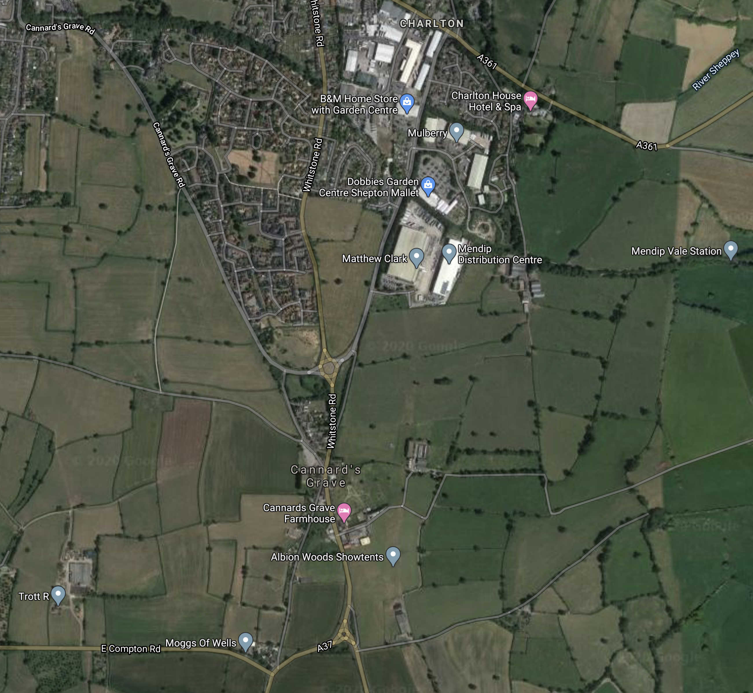
Note.
- The scar of the disused railway passing East-West through the town.
- Mendip Vale station on the East Somerset Railway on the Eastern side of the map.
- The Cannard’s Grave area of the town, with what appears to be a new road system.
Would it be possible to extend the East Somerset Railway to a new Parkway station in the Cannard’s Grave area?
It certainly looks the most likely plan.
This map clipped from Wikipedia, shows the route of the railway.
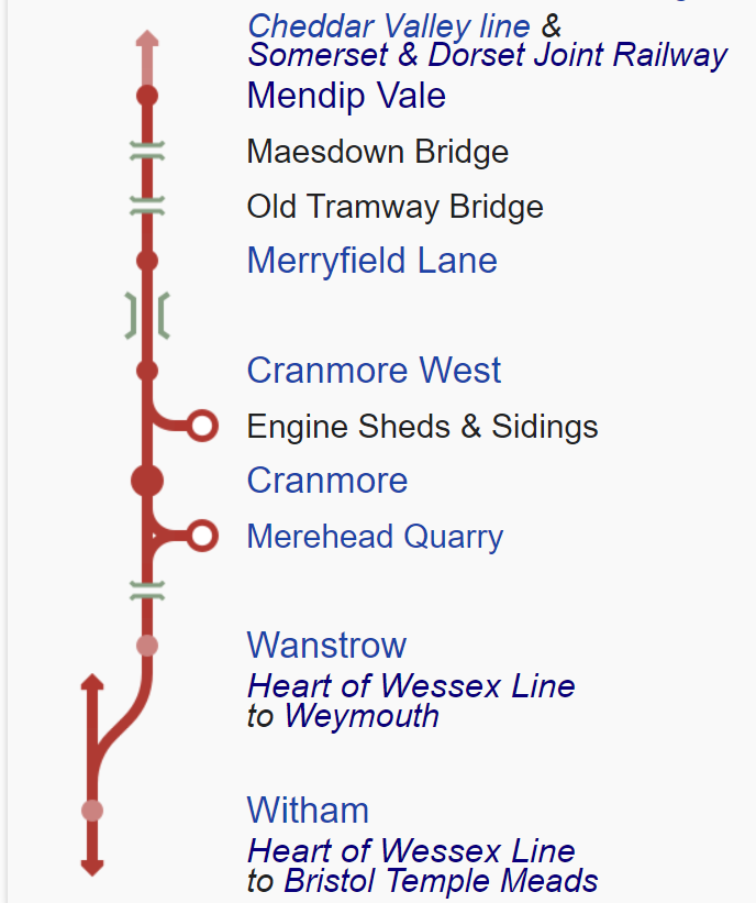
The railway may be only 2.5 miles long, but it does provide a connection for the important Merehead Quarry to the UK rail network.
The tracks to the Quarry and Shepton Mallet join up to the South West of the quarry before joining the Heart of Wessex Line, that connects Bristol Temple Meads and Weymouth stations via Bath Spa, Bradford-on-Avon, Trowbridge, Westbury, Frome. Castle Cary and Yeovil.
Passenger Train Services
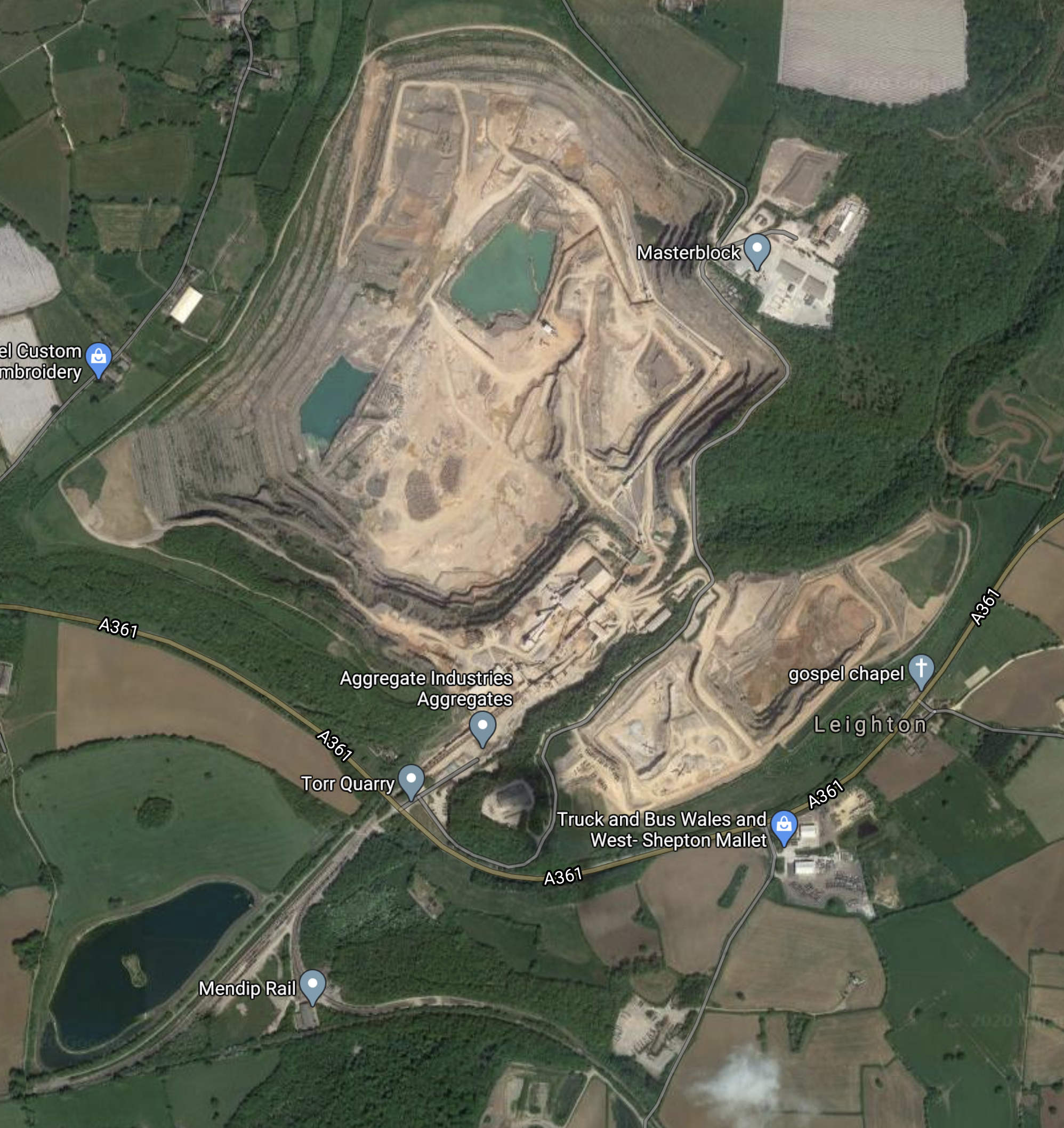
This Google Map shows East Somerset Junction, where the branch line joins the Heart of Wessex Line.
Note.
- Frome, Westbury, Bath Spa and Bristol Temple Meads are to the North East.
- The double-track railway going South-West is the Heart of Wessex Line to Castle Cary, Yeovil and Weymouth.
- The East Somerset Railway is the single-track joining from the West.
There is no direct access to and from the branch from the South-West. But then all of the quarry traffic needs to go to and from via the junction at Westbury.
In Westbury Station – 30th July 2020, I discussed the development of Westbury station.
This was my conclusion.
Could Westbury station develop into a zero-carbon rail transport hub for Wiltshire?
-
- It has an hourly train service between London Paddington and Exeter St. Davids.
- It has an hourly service between Bristol Temple Meads and Weymouth.
- There are hourly services to stations like Bath Spa, Bradford-on-Avon, Bristol Temple Meads, Chippenham, Dorchester, Frome, Swindon, Taunton, Trowbridge and Yeovil
It could be electrified to charge battery electric trains as they pass through.
Perhaps, an hourly service between Westbury and Shepton Mallet Parkway stations could be added to the services?
- I estimate that Westbury and Shepton Mallet Parkway stations are about 13.5 miles apart
- With an intermediate stop at Frome, I estimate that it would be a twenty minute journey.
- A shuttle would need just one train and could run a passenger-friendly clock-face timetable.
- A two-car diesel multiple unit would probably be good enough to open the service.
- The service could be fully-integrated with all the other services passing through Westbury.
It would also be a shuttle service, that could be run using a battery electric train charging at Westbury station.
Vivarail’s Pop-up Metro
The route could be ideal for Vivarail’s Pop-up Metro.
- It is 27 miles for a round trip.
- I’m sure space could be found for charging at either Shepton Mallet or Westbury.
- A two-car train would be large enough.
it could be an extension to the Transwilts local system.
Conclusion
I like this proposal.
- The only infrastructure required is the Park-and-Ride station at Shepton Mallet Parkway.
- Much of the route is currently used by heavy freight trains.
- I doubt that the East Somerset Railway will object.
- I’m sure, that a diesel multiple unit could be found for the shuttle.
- The passenger services will have good connections at Westbury station.
In a future zero-carbon world, it could be run by battery electric trains, charging at Westbury station.
