Thameslink Information At London Bridge Station – 3rd March 2018
This picture was taken at the foot of the escalators leading to the Thameslink Platforms 4 and 5 at London Bridge station.

The trains were fairly crowded, although it was mid-afternoon.
But at the bottom of the escalators under the tracks going through the station, in the vast space, there were relatively few travellers.
I should visit in the Peak.
But it does seem the design is working.
More Thameslink Trains Serving The East Coast Main Line From May 20th 2018
The National Rail timetable is now showing the following new Thameslink trains serving the East Coast Main Line.
There will be two trains per hour (tph) between Peterborough and Horsham.
- XX:26 and XX:56 – Peterborough
- XX:08 and XX;38 – Finsbury Park
- XX:00 and XX:30 – London Bridge
- XX:08 and XX:38 – Horsham
Note.
- Trains take two hours and 45 minutes.
- Stops include Huntingdon, St. Neots, Hitchin, Steveange and Finsbury Park, to the North of the Thames.
- The trains call at St. Pancras Thameslink, Farringdon, City Thameslink and London Bridge in the core.
- Stops include East Croydon, Gatwick Airport, Three Bridges and Crawley to the South of the Thames.
- The first train is 05:24 from Peterborough.
Trains generally leave Horsham at XX:25 and XX:55.
There will be one tph between Cambridge and Brighton.
- XX:54 at Cambridge
- XX:52 – Finsbury Park
- XX:15 – London Bridge
- XX:19 – Brighton
Note.
- Trains take two hours and 25 minutes.
- Stops include Royston, Hitchin, Steveange and Finsbury Park, to the North of the Thames.
- The trains call at St. Pancras Thameslink, Farringdon, City Thameslink and London Bridge in the core.
- Stops include East Croydon, Gatwick Airport, Three Bridges and Haywards Heath to the South of the Thames.
- The first train is 05:54 from Cambridge.
Trains generally leave Horsham at XX:07.
But going to Gatwick, I might go to Finsbury Park, where I can now get three trains per hour to the Airport.
- XX:08 taking around 70 minutes
- XX:38 taking around 70 minutes
- XX:52 taking around 52 minutes
But coming back, I would take the first train to London Bridge, from where I’d get a 141 bus to just outside my door.
Are The Trains Acceptable?
For my journey of an hour to Gatwick, the trains are just about acceptable.
But, in some ways, I think that passengers from Cambridge and Peterborough will only use Thameslink to South of East Croydon occasionally, as over two hours in a Class 700 train, is an experience, passengers will be reluctant to repeat.
I would do the following.
- Add wi-fi and power sockets.
- Add a few tables to make some groups of four seats, suitable for families.
- Add seat-back tables.
- Make the seats more comfortable.
I’d love to have five minutes with the idiot who signed off the order for these trains, which must be the worst new trains on the UK network. Perhaps, that’s not being harsh enough. I suspect they could be the worst new trains in the world!
I’ve had better passenger comfort in a Pacer, that I wrote about in Is This Really A Pacer In A New Outfit?.
But that journey was only between Rotherham and Sheffield, not say Cambridge and Gatwick.
Noise From Trains Revisited
Nearly, two years ago, I wrote a post entitled Are You Annoyed By Noisy Trains At The Bottom Of Your Garden?.
A few days ago, the post had a comment from a lady saying this.
we live on top of thames link between st pancras and farringdon stations. We are used to the trains having lived here for nearly 30 years. But recently in the last 6 months 2017/2018 the noise and vibration from the trains has increased also the frequency. From before 6am until after 1am in the morning. These new trains make the house rattle and you can feel the vibration through the floor. You have to turn up the radio or TV and visitors always comment on how do you manage to live with it.
No one seems to know anything when I made enquiries to thameslink. Spoke to me as if i was completely mad.
I contacted the lady and the problem seems to be that the eight-car Class 700 trains are the problem.
Now if the twelve-car trains are quieter, it sounds to me, that there must be a peculiar resonance between eight-car trains and the track.
According to Wikipedia, the train formations are.
- Eight-car – Bo’Bo’+2’2’+Bo’Bo’+2’2’+2’2’+Bo’Bo’+2’2’+Bo’Bo’
- Twelve-car – Bo’Bo’+2’2’+Bo’Bo’+Bo’Bo’+2’2’+2’2’+ 2’2’+2’2’+Bo’Bo’+Bo’Bo’+2’2’+Bo’Bo’
Note.
- Bo’Bo’ is a powered-car.
- 2’2′ is a trailer car.
- The plus sign separates each car.
From my engineering knowledge, could it be something to do with the fact that the twelve-car train has four trailer cars in the middle of the train, whereas the eight-car train has only two.
I suspect that these trains were designed as twelve-car units and because of the problems of lengthening some platforms, Siemens were asked if they could build an eight-car version as well.
With the dynamics tuned to the twelve-car train, I’m not surprised that the eight-car trains create an annoying resonance.
I shall be using my Freedom Pass to investigate this phenomenon, by riding in the middle sections of these trains.
The Cranleigh Line
Looking for possible privately-funded rail projects, I have come across the Cranleigh Line on Wikipedia.
This is part of what is said on Wikipedia about Possible Reopening, in a eport by Buchanan and Partners in 1994.
The report estimated that around 500 car users could transfer to rail each day. The cost of reinstating the line between Guildford and Cranleigh was projected at £24 million which would include the base, civil, electrical, engineering and signalling works. It did not include land acquisition costs, legal costs and bridge works. The reinstatement of the bridge over the River Wey was costed at £750,000.
The report concluded that, based on a preliminary analysis of the line’s potential returns, re-opening would not be feasible. The line was, according to the report, likely to recoup only 3% of the capital investment in the first year of re-opening, and this without taking into account its operating costs. British Rail usually insisted on a figure of at least 8% before investing capital into re-opening a line. Nevertheless, the County Council decided to commission a detailed economic feasibility study by British Rail into the line’s potential for re-opening, and looked into the possibility of using a light railway or tramway substitute.
What would a report say now?
Given that the line runs between the busy stations at Guildford and Horsham, the latter of which has a Thameslink frequency of two trains per hour, I think that the answers would be very different.
The route would also be one, that could be run by a third-rail tram-train!
Consider.
- The tram-trains would use battery power, where there is no third-rail electrification.
- The route between Guildford and Peasmarsh Junction is electrified and has no stations.
- The route between Horsham and Stammerham Junction is electrified and has no stations.
- Between Peasmarsh Junction and Stammerham Junction, there were stations at Bramley & Wonersh, Cranleigh, Baynards, Rudgwick and Slinford.
- Stations could be rebuilt and added to as required.
- Between Peasmarsh Junction and Stammerham Junction, the new line would be without electrification.
Could the new line share the route with walkers and cyclists?
I think there is a chance here to create a new type of light rail link!
MK-Bedford New Line Mooted
The title of this post, is the same as the title of an article in the April 2018 Edition of Modern Railways.
This is the first paragraph.
A new railway between Milton Keynes and Bedford for the East West Rail project has been suggested as a way of avoiding problems with the Marston Vale Line, where the hourly stopping service and numerous level crossings limit capacity for through regional trains.
Another aim is that the next phase of the project should be completed by the end 2022, which is between a one and two years earlier than the existing target.The Chairman of the East West Rail Company, then said he’d like the the railway to open in 2027.
The article says a new route will be expensive, but innovative ways of doing things could help.
Consider these points about the Marston Vale Line
- The stations need development.
- There are at least thirteen level crossings.
- New houses are being built near some stations.
- The operating speed is just 50 mph.
- Finding a new route at Fenny Stratford, Woburn Sands, Aspley Guise, Ridgmont and Lidlington could be difficult.
- The railway passes under the M1 and the A421, so moving these crossing points could be difficult.
It’s all a complicated design problem.
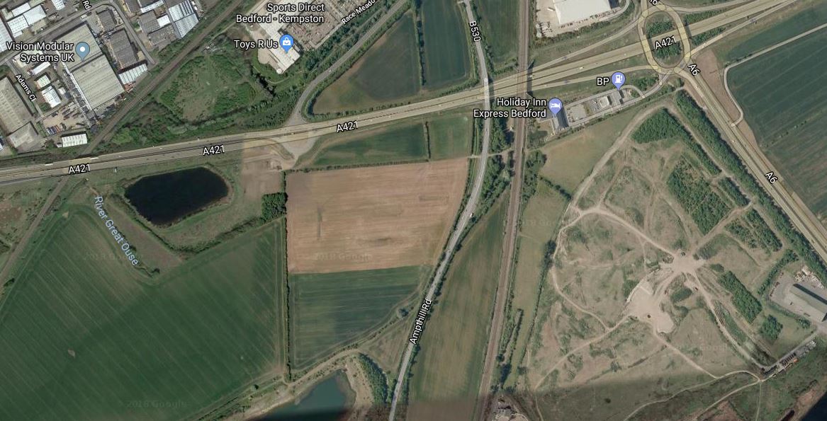
East West Rail could borrow a trick from the Heathrow Southern Railway, which is planned to run alongside the M25 to get to Heathrow. The new railway could be routed alongside the A421 in the Bedford area.
This Google Map shows the A421 to the South of Bedford.
Note.
- The Marston Vale Line goes across the North West corner of the map.
- The Midland Main Line goes across the map in a North-South direction.
- The roundabout at the North East connects the A421 to the A6.
- The building by the roundabout is a hotel.
If the East West Rail Link was routed alongside the by-pass a station could be built where the two lines cross.
- The Midland Main Line and Thameslink would be linked to the East West Rail Link.
- Passengers for Bedford would be able to use the frequent Thameslink service to get to the town.
- A big Park-and-Ride could be built.
- Marston Vale Line services would take the same route as they do now, via Bedford St. Johns station.
If it was desired, chords could be built to enable services on the East West Rail Link to serve Bedford with a reverse in Bedford station.
Oxford has a Parkway station, Milton Keynes has a Milton Keynes South station at Bletchley, Cambridge will probably have a Cambridge South station, so why shouldn’t Bedford have a Bedford South station?
Thameslink Should Be On The Tube Map
Consider.
- Cambridge and Gatwick Airport are two of the most important destinations within an hour of Central London.
- The outer branches of Thameslink to East Croydon, St. Albans, Welwyn Garden City and Wimbledon act in a similar manner to Underground Lines.
- The central core of Thameslink will be used by many as just another Underground Line.
- The London Overground is on the Tube Map.
- Crossrail will be on the Tube Map.
For these and other reasons, the London sections of Thameslink should be on the Tube Map.
If Thameslink should be added, what about the Northern City Line?
A Connection Between City Thameslink Station And The Docklands Light Railway
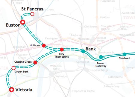
In the Wikipedia entry for the Docklands Light Railway, there is a section describing a proposed Euston/St. Pancras Extension.
This is said.
In 2011, strategy documents proposed a DLR extension to Euston and St Pancras. Transport for London have considered driving a line from City Thameslink via Holborn north to the rail termini. The main benefit of such an extension would be to broaden the available direct transport links to the Canary Wharf site. It would create a new artery in central London and help relieve the Northern and Circle lines and provide another metro line to serve the High Speed line into Euston.
This map from Transport for London, shows the possible Western extension of the DLR.
With all the problems of the funding of Crossrail 2, that I wrote about in Crossrail 2 Review Prompts Fresh Delays, could this extension of the DLR, be a good idea?
Consider,
- Victoria, Euston and St. Pancras are prosposed Crossrail 2 stations.
- It would link Canary Wharf and the City of London to Eurostar, Northern and Scottish services and High Speed 2.
- It would give all of the Docklands Light Railway network access to Thameslink.
- A pair of well-designed termini at Euston and St. Panras would probably increase frequency and capacity on the Bank branch of the system.
- The DLR is getting new higher capacity trains.
- Bank station is being upgraded with forty percent more passenger capacity.
- Holborn station is being upgraded and hopefully will be future-proofed for this extension.
- One big advantage at City Thameslink, is that Thameslink and the proposed DLR extension will cross at right-angles, thus probably making designing a good step-free interchange easier.
- The Bank Branch of the DLR currently handles 15 tph, but could probably handle more, if they went on to two terminal stations at St Pancras and Victoria..
- Waterloo and City Line can run at twenty-four tph.
Cinderella she may be, but then she always delivers, when there is a desperate need, just as she did magnificently at the 2012 Olympics.
The only problem with this extension of the DLR, is that compared to the rest of the system, the views will be terrible.
For myself and all the others living along the East London Line, with a step-free change at Shadwell, we would get excellent access to Euston, Saint Pancras and Victoria
But could the line still be called the Docklands Light Railway, as it spreads its tentacles further?
A Pedestrian Connection Between City Thameslink Station And St. Paul’s Tube Station
In the Wikipedia entry for City Thameslink station, there is a section called Future Proposals.
This is said.
An underground passageway linking City Thameslink to St Pauls tube station to provide an interchange between the London Underground Central line and National Rail services on the Thameslink (route) has been suggested by London TravelWatch in a report in 2014 which suggested it would benefit passengers travelling from the Central Line catchment to Gatwick and Luton Airports.
St. Paul’s tube station does not have the best access, with two sets of escalators to get to the Easttbound platform, which is underneath the Westbound one.
This picture shows the lobby at the bottom of the second set of escalators.
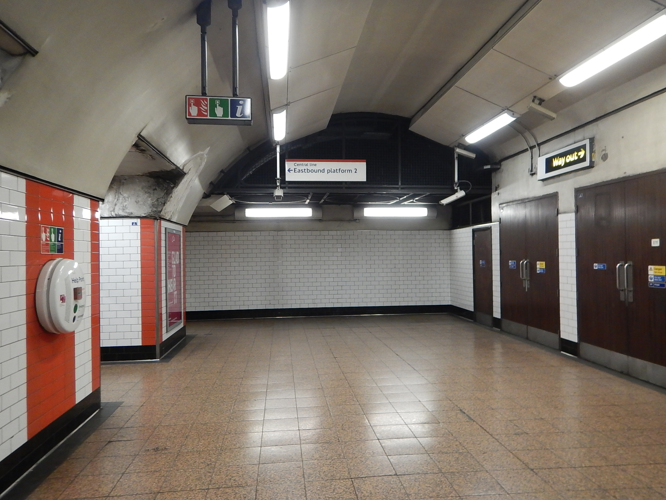
The Eastbound platform is through the opening on the left.
Could a tunnel to the West be built from this lobby?
This map from carto.metro.free.fr shows the layout of lines at City Thameslink and St. Paul’s.
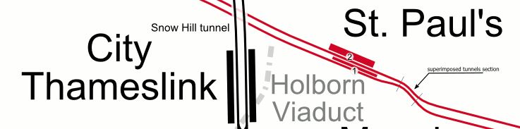
It would appear that a pedestrian tunnel could be bored from the Western end of the platforms at St. Paul’s to connect to the Northern end of City Thameslink.
- A travelator could be included.
- It would create an accessible route into St. Paul’s station.
- Intermediate entrances could be provided to give access to important sites like the Western end of St. Paul’s cathedral.
Property development between the two stations will probably be the catalyst to get this link built.
These pictures show Paternoster Square, which lies to the North of St. Paul’s cathedral.







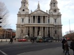
I wonder if provision was made for an entrance, when the area was redeveloped around twenty years ago.
It would surely be an ideal place for an intermediate step-free entrance to any pedestrian tunnel linking St. Paul’s and City Thameslink stations.
Conclusion
Done properly, it would do the following.
- Add step-free access at one of London’s most important stations for tourists.
- Create a link between Thameslink and the Central Line.
- Create a shared entrance to both stations in the Paternoster Square area.
Obviously, the figures would have to add up.
Thameslink’s Sutton Loop Services Appear To Be Starting From Luton
I just looked at Thameslink’s core traffic on nationalrail.co.uk and it appears that services on the Sutton Loop Line are now starting from Luton.
Are there operational issues or are Thameslink changing the timetable?
It was operational, as a passenger had been taken seriously ill!
Could The Waterloo And City Line Have An Intermediate Station At Blackfriars?
The Waterloo and City Line between Bank and Waterloo stations, is London’s shortest Underground Line.
In the Wikipedia entry for the line, there is a section entitled A Blackfriars Station Proposed. This is said.
In 1934 the LPTB, which now operated most of the London Underground system, proposed that the Waterloo & City should have a new intermediate station at Blackfriars, connecting with the District line station there. They further proposed that the Waterloo & City line should be extended to Liverpool Street station and Shoreditch, the trains there continuing over the East London Railway to New Cross and New Cross Gate. It is not clear whether the scheme had been costed, but nothing came of it.
So have things changed since 1934?
The Problem Of An Intermediate Station
The line is only a mile and a half long and trains take about three minutes to go from end-to-end.
Even allowing for the turn-round time at each end of the route, it must be very difficult with the current rolling stock to accommodate the time needed for an intermediate station.
Thameslink Has Been Built
Thameslink didn’t exist in the 1930s and when it is completed, there will be 24 trains per hour (tph) passing through Blackfriars station.
Consider.
- The Thameslink frequency could increase to 30 tph.
- How many Thameslink passengers want to go to Bank and Waterloo stations?
- Blackfriars station is fully step-free.
I certainly think, that a Blackfriars station on Thameslink would be used by passengers.
Trains Can Be Fully Automated
As a Control Engineer, I believe that with the right automation, that capacity on the line can be increased.
I know the Unions attitude to driverless trains, but if ever there was a line, that would benefit, it is the Waterloo and City Line.
Perhaps, the driving position should be in the middle of the train, so the driver wouldn’t have to change ends and drove the train using CCTV.
New Trains Are Coming
London Underground has a plan to renew a lot of the trains, starting with the Piccadilly Line.
These trains will have the following characteristics.
- Walk-through cars.
- Shorter stopping times at station.
- Improved performance.
- Air-conditioning and other improved passenger features.
Would these trains and improved signalling enable an intermediate stop at Blackfriars to be added to be added to the line?
Conclusion
I obviously haven’t seen Transport for London’s figures, but I’m sure, there will come a time, when an intermediate station at Blackfriars will be a project worth doing.

