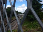
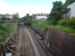
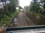
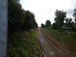
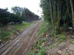
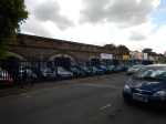
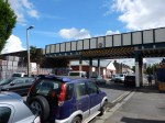
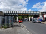
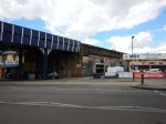
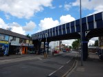
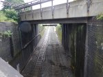
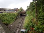
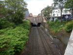
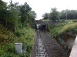
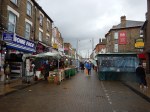
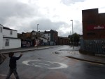
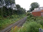
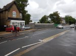
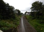
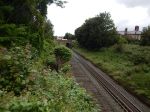
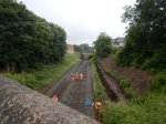
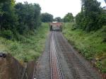
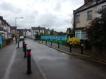
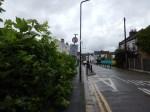
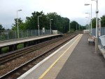
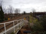
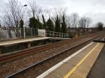
Between Walthamstow Queen’s Road And Leyton Midland Road Stations
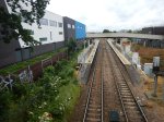
These pictures show the Gospel Oak and Barking Line (GOBlin) between Walthamstow Queen’s Road and Leyton Midland Road stations.


This part of the route isn’t as interesting as the section I covered in The Bridges Of Walthamstow.
Note.
- In my peek at Walthamstow Queen’s Road station, nothing much seemed to have happened at the station.
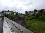
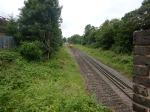
- The track in the Gospel Oak direction appears to have been removed and track replacement seemed to be happening in the region of the Baker’s Arms Bridge.
- The cutting is well-buttressed between the Shrubland Road Bridge and the relatively-new Alobert Road Bridge
- You can see pairs of piles for electrification gantries east of Queen’s Road Bridge.
- The embankment that carries the line through North East London appears to start around the Boundary Road Bridge.
- The railway arches don’t seem to be in the worst of conditions, even if they do have a touch of the Arthur Daley’s.
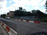
What I find strange about this line is the lack of a station at Bakers Arms. It’s not that there ever was one, but as the line crosses the major Lea Bridge Road and on this line, that is usually a good enough reason for a station, I’m surprised the Victorians didn’t build one.
The Barking Gospel Oak Rail User Group suggest one in this page on their web site.
There may be a lot of reasons to build a station at Bakers Arms.
- It is near to several new hotels and housing developments.
- It is better positioned than the two adjoining stations.
- It is well served by lots of buses.
- It is on a busy main road.
But contrary to that.
- The buses can take you to the better connected stations of Walthamstow Central and Lea Bridge, in under fifteen minutes.
- It might be a difficult site on which to build a station.
- Reopening the Hall Fsrm Curve may be a better option.
It should probably have been built, when one of the adjoining developments was constructed.
‘Wheelchair vs. Buggy’ Case Goes To The Supreme Court
The latest in this story from Wetherby is in this article on the BBC, which is entitled Supreme Court to hear ‘wheelchair vs buggy’ bus case.
I think it is interesting that this case comes from Wetherby, which I suspect doesn’t have such an intensive bus service as I have here in London or as there is in Manchester, Newcastle or Liverpool.
In London, I have never seen an argument over the wheelchair space on a bus, although I have seen some severe, but helpful reorganising, when a wheel-chair needs to be accommodated.
In London because bus frequencies are higher and there are generally shelters these days, I would suspect that most people, be they able-bodied, in a wheel-chair or with a buggy, accept that they may have to wait for the next bus.
But if there is only one bus an hour, it’s chucking it down and there’s no shelter, it’s more likely that passengers will refuse to co-operate.
So one way to mitigate problems like this, is to provide a better bus service, with more buses, better shelters and improved information.
But that all costs money!
I am not disabled, although I don’t drive because of an eyesight problem. I also because of my stroke, could have ended up in a wheelchair, so I sympathise, with those who have to use a wheelchair or electric buggy to get about.
I regularly, see passengers in wheelchairs use London buses, with their central entrance/exit, which leads straight into the wheelchair space. The design, also means the driver can deploy the ramp and do everything they need without leaving the cab. In loading a wheelchair, I’ve also seen buggy-pushers take advantage of the deployed ramp to get out of the bus to fold the buggy before getting back on.
But outside of London, where often the wheelchair user has to get in the front entrance by the driver, this creates all sorts of delays and I’ve seen on a crowded bus, virtually everybody on the lower-deck get off, to allow the wheelchair to pass through.
I wonder if outside of London, there is more resentment of wheel-chair users on buses, than there is in the capital.
In my view, all new buses should be designed for central wheelchair entrance/exit as this is so much more efficient.
I once had a discussion with a Manchester Buses union rep on a Manchester bus. He was all for the London system of no-money-on-buses, with a front entrance and central-exit passenger flow, as it cut attacks on staff.
Since then, London has gone even further and now with the ability to use any contactless bank card as a ticket, London now has one of the most advanced bus-ticketing system in the world.
We need a standardised bus-system all over the UK. It might actually encourage more people to use this often-neglected form of public transport, which would generate more revenue for a better system.
The Bridges Of Walthamstow
I have been meaning for some time to walk the route of the Gospel Oak to Barking Line (GOBlin) between Walthamstow Central station in Selborne Road to Blackhorse Road station.
But now the line is closed for electrification work, I thought it would be an appropriate time to do it, taking photographs as I walked.


To cross all the bridges, I was constantly doubling back on myself, using a route of.
- West on Selborne Road.
- Right onto Vernon Road
- Left onto Walthamstow High Street
- Right onto Palmerston Road
- Left onto Northcote Road
- Right onto Pretoria Avenue
- Right onto Warner Road and back to Northcote Road
- Left onto Palmerston Road
- Left onto Walpole Road, Suffolk Park Road and The Links
- Right onto Pretoria Road
- Left onto Forest Road
After a short detour to look at the bridge on Blackhorse Road, I arrived at the station, where I took a bus alongside of the GOBlin to Tottenham Hale station.
This Google Map shows Walthamstow Central and Blackhorse Road stations, and the portion of the GOBlin in the area.
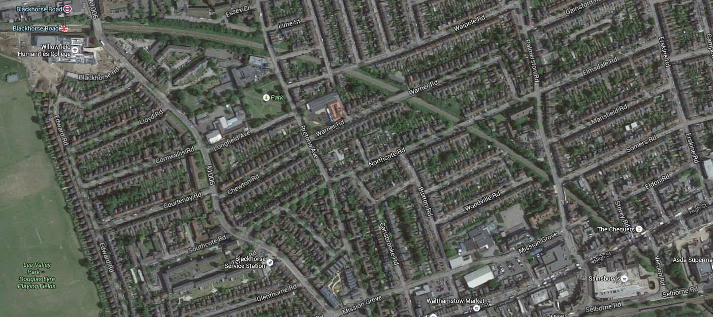
The Bridges Of Walthamstow
Note in both the photographs and the map.
- There are eleven bridges including those at Blackhorse Road and Selborne Road.
- Most seem to be in good condition, with Palmerston Road having been recently replaced and others looking as if they have been thoroughly refurbished.
- Only Suffolk Park Road and Stoneydown Avenue Bridges have restrictions on access.
- It would appear that the track going towards Blackhorse Road has been lifted and laying of new track has started at that end.
- There does appear to be some new sheet piling to stabilise the cutting.
- There is ample space on both sides of this section of the line to erect the masts and gantries for the overhead wires.
- I wonder what William Morris would think of the bridge designs.
- I can’t find any information on whether more work needs to be done on the bridge at Suffolk Park Road, except a mention of new public art from 2015.
So in this section at least, it doesn’t appear that there’ll be much problem putting up the overhead wires for the electrification.
Alongside The GOBlin – June 14th 2016
I took these pictures of the Gospel Oak to Barking Line from the top of a 123 bus going between Blackhorse Road and Tottenham Hale stations.

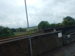


This bus ride will be an easy way to ascertain progress on the electrification.
Nothing much seems to be happening yet!
Will Shoreditch High Street Be Connected To The Central Line?
Every Londoner has their own personal pet hates about the Underground.
One of mine is the lack of an interchange between the East London Line and the Central line at Shoreditch High Street station. The Central line passes under the East London Line and some web sites say that provision was left in the new station for the connection.
This map from carto.metro.free.fr shows the lines around Shoreditch High Street station.
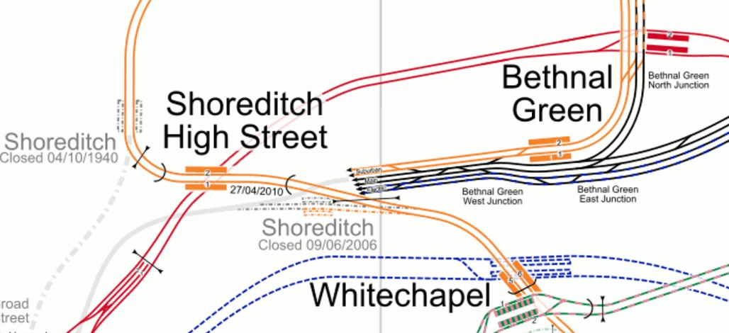
Shoreditch High Street Station
Note how the Central Line platforms at Liverpool Street are in the South West corner of the map.
Some sites also say that the reason for not building the connection, is that the Central line is too crowded and a decision will not be taken until after Crosrail opens. This is the comment on an article about the connection in London Connections.
Don’t expect an interchange with the Central Line until Crossrail 1 is fully operational. The Central Line in its present, heavily overcrowded, state could not possible cope with even more stations.
Perhaps in about 10 years…
It does sound sensible.
Getting West on the Central Line can be difficult from where I live.
I can take a bus to either Bank or St. Paul’s stations, but coming back is a problem, as the bus stops aren’t well placed.
After Crossrail opens, I might take the same bus to Moorgate for the new line or I could get to Crossrail using the East London Line connection at Whitechapel.
It shows how Crossrail is going to add masses of possible new routes to everybody’s travel in London.
Crossrail links with the Central line at Stratford with a cross-platform interchange and more conventionally at Liverpool Street, Tottenham Court Road, Bond Street and Ealing Broadway.
As the East London Line links to Crossrail at Whitechapel, will passengers going from say Anerley to Epping, be happy with a double change at Whitechapel and Stratford? Especially, as the second one would be just a walk across the platform.
I think they will.
But obviously Transport for London will have all the traffic statistics and would know when creating the Interchange at Shoreditch High Street will be worthwhile.
But looking at the map of the lines at Shoreditch High Street station, leads me to wonder if it would be possible to put in an escalator connection to the Eastern end of the Central Line platforms at Liverpool Street station. This map from carto.metro.free.fr shows the Central Line through both stations in detail.

Liverpool Street And Shoreditch High Street Stations
As all of the office blocks on both sides of Bishopsgate, were planned and designed before Crossrail and the London Overground, I do wonder that if they were being designed now, they would build a travelator connection between Shoreditch High Street and Liverpool Street stations, which incorporated another set of escalators to the Central Line.
The Platform For The Future
The June 2016 Edition of Modern Railways has a section about The Railway Industry Innovation Awards 2016.
One is labelled the Platform for the Future.
That probably sounds rather boring, but I’m a great believer in disruptive technology and using new and innovative methods to replace something that is rather dull, with something that is better, quicker to be installed and get working and more affordable.
This is said.
Abellio Greater Anglia and Dura have pioneered the use of a composite platform at Needham Market station in Suffolk, which was installed in just 36 hours.
This installation might be considered surprising as Needham Market station is a Grade II Listed building. So it can’t look like.
A monstrous carbuncle on the face of a much-loved and elegant friend.
But the product comes with these advantages.
- The design life is sixty years.
- A financial saving of 25% is reported.
- As the platforms are built in a factory, the quality should be tip-top.
- Other features like Harrington Humps could be built-in.
Hopefully, this would dissuade even the most determined member of the Heritage Taliban from objecting.
There’s more here on the Dura website. There’s also this video, of the platform being installed at Needham Market station.
This is a picture I took from a p[passing train.

It looks good and who would think it was long-life hard-wearing plastic.
Only members of the Taliban tendency of the Green and Heritage lobbies would probably object!
I think that this product could find lots of applications, in traditional heavy rail, light rail and tramways. Certainly, it could be used to create some of the needed extensions to platforms on the Gospel Oak to Barking Line.
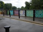
Look at these pictures taken at Harringay Green Lanes station.


Would composite platforms make extending these platforms an easier process?
The company might also have the solution to the dual-height platforms, that some people feel are needed for tram-trains. The Germans certainly use stepped platforms so that different types of tram-trains have step-free access.
In fact, why restrict it to rail applications?
It could be used to provide a disabled viewing platform at somewhere like a horse racecourse or other sporting venue.
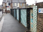
Or how about helping to create step-free bus stops, that I wrote about in One Of London’s Step-Free Bus Stops?
One Of London’s Step-Free Bus Stops
It’s certainly a very good innovation.
When Will The United States Realise That Guns Kill People?
On the wall of my office, there used to be a picture of my wife presenting a racing trophy to a racehorse trainer.
Both are now dead.
- My wife died from a squamous cell carcinoma of the heart.
- The trainer died because of an argument and a gun was available and used to settle it.
We fight cancer with common sense and all the tools that science has given us.
Isn’t it about time, that common sense is applied to the problem of guns in the United States and other countries where they are responsible for a high murder rate?
What Will Be The Service On The Great Northern Lines After Thameslink Opens?
When I did the short trip from Essex Road station on the Northern City Line, that I wrote about in Never On Sunday, I was surprised to see that the frequency of the service was Transport for London’s turn-up-and-go frequency of 4 trains per hour (tph), with 2 tph to going to Hertford North, with 1 tph extended to Stevenage and 2 tph to Welwyn Garden City.
The services at Essex Road station in the Off Peak include these trains.
- 6tph to London Moorgate
- 3tph to Welwyn Garden City via Potters Bar
- 3tph to Hertford North (1tph extended to Letchworth Garden City)
It is interesting to note that between 0800 and 0900 on a weekday morning, thirteen trains arrive at Moorgate.
From 2018, the new Class 717 trains will start to run on the Northern City Line. The number of passengers on this line will surely grow as the Southern terminus of Moorgate station will be on Crossrail from December 2018.
Assuming these six-car Class 717 trains can carry about half that of a 12-car Class 700 train, then in that hour they could bring 4,329 passengers into Moorgate station.
Will the low-level platforms at Moorgate station be able to cope?
Probably easily, if there is a direct tunnel and escalator access to Crossrail.
This map from carto.metro.free.fr shows the various lines at Moorgate.
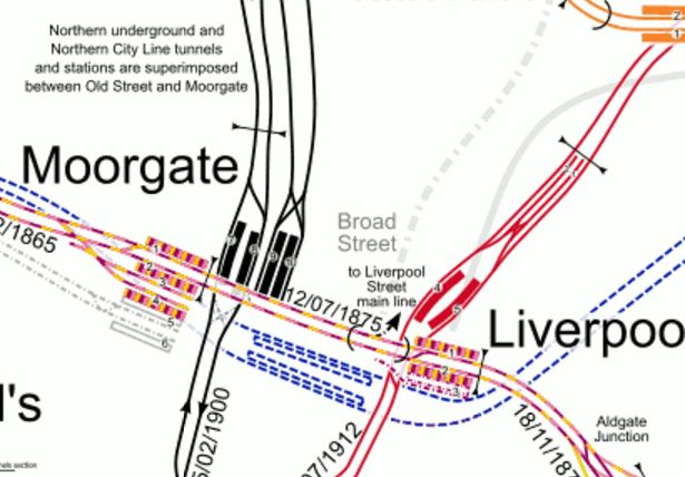
Note.
- The Northern City Line is superimposed on top of the Northern Line at Moorgate station.
- The 200 m. long Crossrail platforms almost stretch between Moorgate and Liverpool Street stations.
- Interchange between the Northern Line at Moorgate and the Central Line will probably be a three hundred metre walk.
- Crossrail should mean that all Liverpool Street to Moorgate interchanges will be desert dry in the wettest weather.
If this massive interchange doesn’t create a need for more capacity on the Northern City Line, I’ll be very surprised.
As there have been improvements to the lines on the Great Northern Route, between Finsbury Park and Alexandra Palace stations, I wouldn’t be surprised that when Crossrail opens, this Cinderella line, that nobody wanted is running eight, ten or even more tph between Moorgate and Finsbury Park stations and further up the route.
The services on the Great Northern Route are intense, but despite that, the route has some of the most crowded trains in the UK..
Thameslink is coming and that will change everything dramatically.
At present Cambridge has 4 tph to Kings Cross in the Off Peak, of which two tph are non-stop Cambridge Cruisers.
When Thameslink connects to Cambridge, the provisional timetable says it will add 4 tph semi-fast trains between St. Pancras Thameslink and Cambridge.
Thameslink haven’t said what services they will retain between Kings Cross and Cambridge, but I did read somewhere that they want to hold on to the Class 387 trains to run the Cambridge Cruisers.
At present, Peterborough has 2 tph Great Northern services to Kings Cross, in addition to several non-stop expresses.
As with Cambridge, Peterborough will get an additional 4 tph, when Thameslink opens.
I think the outcome will be lots of direct services between Cambridge or Peterborough in the North and Kings Cross or St. Pancras Thameslink in the South.
If you are prepared to change just once, you’ll be able to travel between any station North of Finsbury Park to any of the three London terminals; Kings Cross, Moorgate and St. Pancras Thameslink.
I believe that because Thameslink has such a large number of stations and connections, that many passengers will have a wide choice of route.
There is also the performance and quality of the various trains on the routes to consider.
- The current Class 365 trains are 100 mph trains built in the 1990s. They are starting to look dated as I wrote in The Class 365 Trains Are Looking Dated.
- The Class 387 trains are 110 mph trains built in the last few years. They are a quality long-distance commuter train.
- The Class 700 trains are 100 mph trains, that are being delivered at the present time.
- The Class 717 trains could have a similar performance to the Class 700 trains. I will be very surprised if they are not 100 mph trains.
A succession of 100 mph plus trains speeding up and down the Great Northern Route won’t be a slower service than is currently offered.
There would probably be four semi-fast trains to and from both Northern destinsations, stopping at all major stations, with well-connected stopping trains serving the intermediate stations.
There might even be service patterns like say four tph between Moorgate and Welwyn Garden City stopping at all stations, which have a same platform interchange with four tph stopping services to Cambridge and Peterborough. So from say Foxton to New Barnet, you’d always change at Welwyn Garden City.
As an example of how the new improved Thanmeslink will help passengers, look at the routes from my home to Cambridge.
I could.
- Take a 277 bus to Highbury and Islington station and get a Victoria Line train to St. Pancras for a Thameslink train to Cambridge.
- Take a 38 bus or walk to Essex Road station and get a Northern City Line train to Finsbury Park for a Thameslink train to Cambridge.
- Take a 141 bus to Moorgate station and get a Northern City Line train to Finsbury Park for a Thameslink train to Cambridge.
- Take a 277 bus or walk to Highbury and Islington station and get a Northern City Line train to Finsbury Park for a Thameslink train to Cambridge.
- Take a 30 bus to Kings Cross station and get a Cambridge Cruiser to Cambridge.
The possibilities will be endless.
I wouldn’t take the first option, as St. Pancras is A Fur Coat And No Knicker Station, with a long walk between the Victoria Line and Thameslink.
My choice of route, will probably be decided by the first bus that arrives and the quality of the smile on the driver’s face.
Are Sainsburys Winning The Bag War?
Since the five pence charge was introduced for plastic bags in England, there has been very little innovative thinking by shops about how they could use the bags to drag people into their shops.
Summing up the shops I use and the comments of others, I would say this.
- Waitrose – Thin and useless
- Tesco – Thin and useless
- Marks and Spencer – Not too bad!
And then there’s Sainsburys!

A Reuseable Orange Plastic Bag From Sainsburys
They are surely the best, as you can fold them flat and then into a size to fit in a coat pocket or bag.
The one in the picture is probably six or seven weeks old.
One day last week, I needed a few items to complete my supper like some strawberries and I hadn’t got a bag with me. So I walked past Marks and Spencer and Waitrose to Sainsburys and bought them there together with a 5p. bag.
Do you think that Sainsburys have deliberately made a 5p. bag that lasts to attract shoppers to their stores?
Judging by the number of orange bags, I see on the streets of London, I certainly think Sainsburys have been thinking this one through.
- Orange bags are easy to spot, so you always take one.
- As they’re easy to fold, some might fold them and put them in their pocket or bag after putting the shopping away.
- Seeing lots of orange bags on the street, reminds shoppers to get what they need at Sainsburys.
- Because of the quality of the bag, it makes you think well of Sainsburys and their products.
On the other hand, IKEA deliberately make their blue bags impossible to fold, so you leave them behind, when you go shopping.
