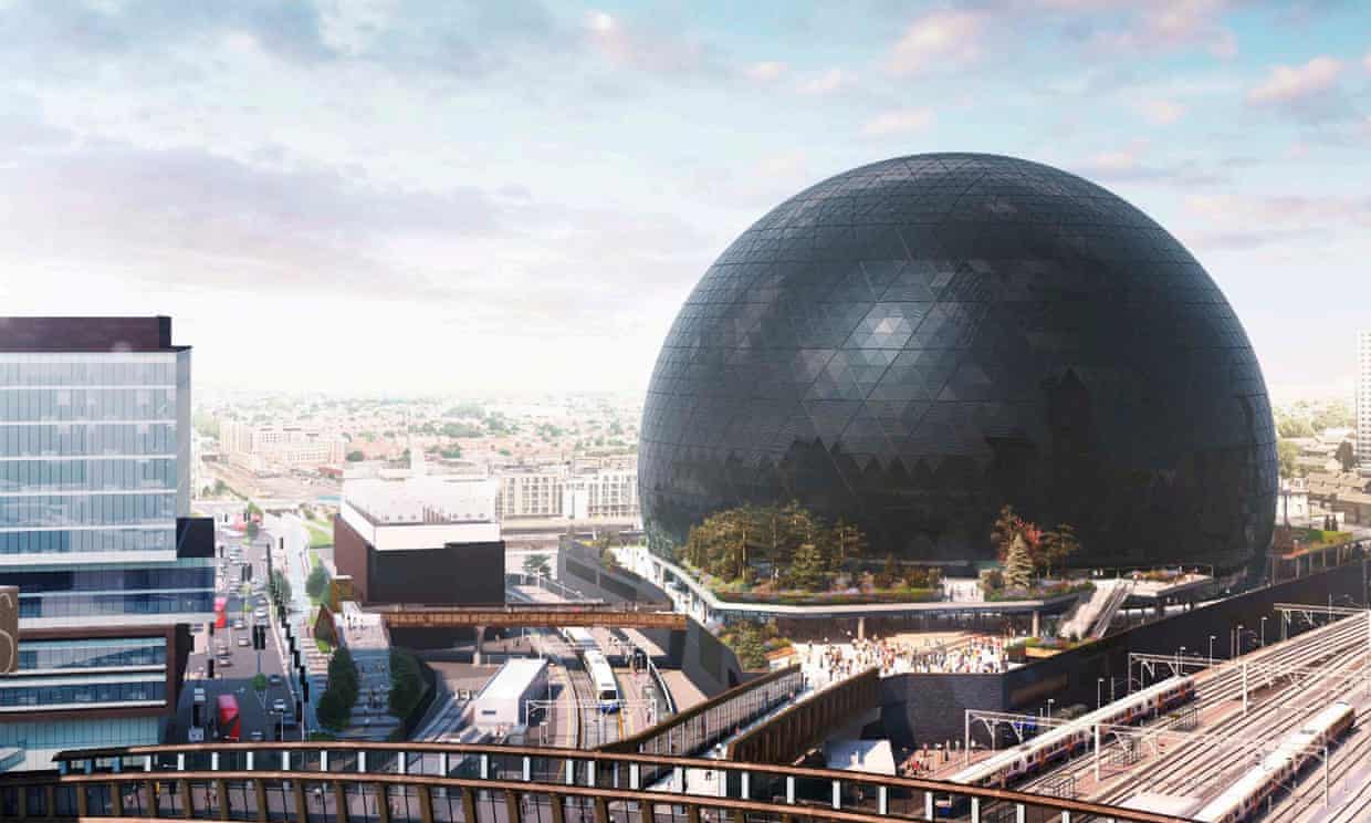
The Proposed MSG Sphere At Stratford
I have been reading about the proposed MSG Sphere at Stratford in East London.
Note.
- The railway lines to the left of the sphere are platforms 11 and 12 of Stratford station on the West Anglia Main Line.
- The Great Eastern Main Line goes off to the right.
This article in the Guardian gives a good outline of the building and its promoters and backing.
But it won’t be plain sailing to get planning permission, as this paragraph explains.
Worries have already been voiced by local residents. A petition launched four months ago argues that the building will block sunlight, create light pollution and increase traffic in the area. Others have opposed MSG, whose executive chair, James Dolan, has donated funds to Donald Trump, and was on the board of the Weinstein Company from 2015-16. Beverley Whitrick, strategic director of the Music Venue Trust, has argued< that some audiences would feel uncomfortable in a venue from a Trump backer.
Protestors also believe the site should be used for housing, as Newham has over 25,000 households on the housing waiting list.
This Google Map shows the site.
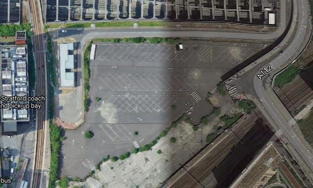
Note.
- The site was used as a coach park during the 2912 Olympics.
- The Channel Tunnel Rail Link runs across the Northern edge of the site.
- The Great Eastern Main Line runs along the South-Eastern edge of the site.
As the sphere will be five hundred feet across, it must almost fill the site.
And then there’s this article in The Telegraph, which is entitled Crossrail Objects To Plan For London Mega-Venue.
This is the introductory paragraph.
Crossrail’s operator is seeking to block plans for a “second O2” in London, over concerns flashing lights from the proposed entertainment venue could cause crashes, with trains travelling at up to 80mph.
Crossrail have a serious point.
Ian Publishes Details Of Future Developments At Euston And Euston Square Underground Stations
This post on the Ian Visits blog is entitled A New London Underground Entrance To Euston Station.
The Underground Lines In The Euston Station Area
This map from carto.metro.free.fr shows the Underground Lines in the Euston station area.
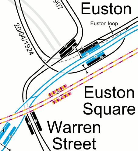
Note.
- The sub-surface lines run underneath the busy Euston Road.
- Platform 2 at Euston Square station has no lift or escalator.
- Platform 1 at Euston Square station has a lift, which also serves the subway.
- To connect between the sub-surface lines at Euston Square and the deep lines at Euston means a walk on the surface.
- Euston station only has two up and two down escalators and no lifts for the six deep-level platforms.
- To connect between the Bank and Charing Cross branches of the Northern Line is often along a very crowded passage.
This interchange has not been fit for purpose since the Victoria Line was built in the 1960s.
A Second Entrance To Euston Square Station
One of the key projects to unlock the interchange, is to create a subway from the current Euston station.
It will lead to a new entrance placed in the middle of Gordon Street.
The subway will have stairs, escalators and/or lifts to connect to the Eastern ends of the current Euston Square platforms.
Ian showed this diagram of the subway.
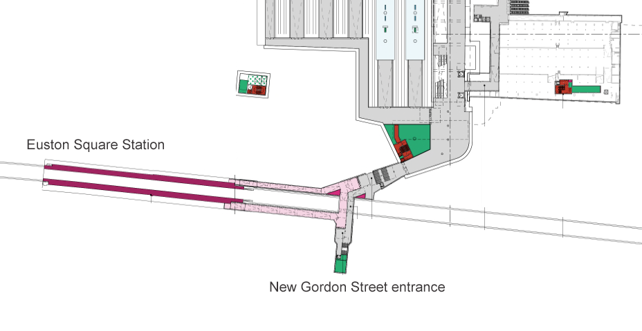
Note.
- It serves both platforms at Euston Square station.
- It looks to be reasonably wide and level.
These are some pictures I took on a walk round the area.


This is a possible future visualisation from Ian’s site.
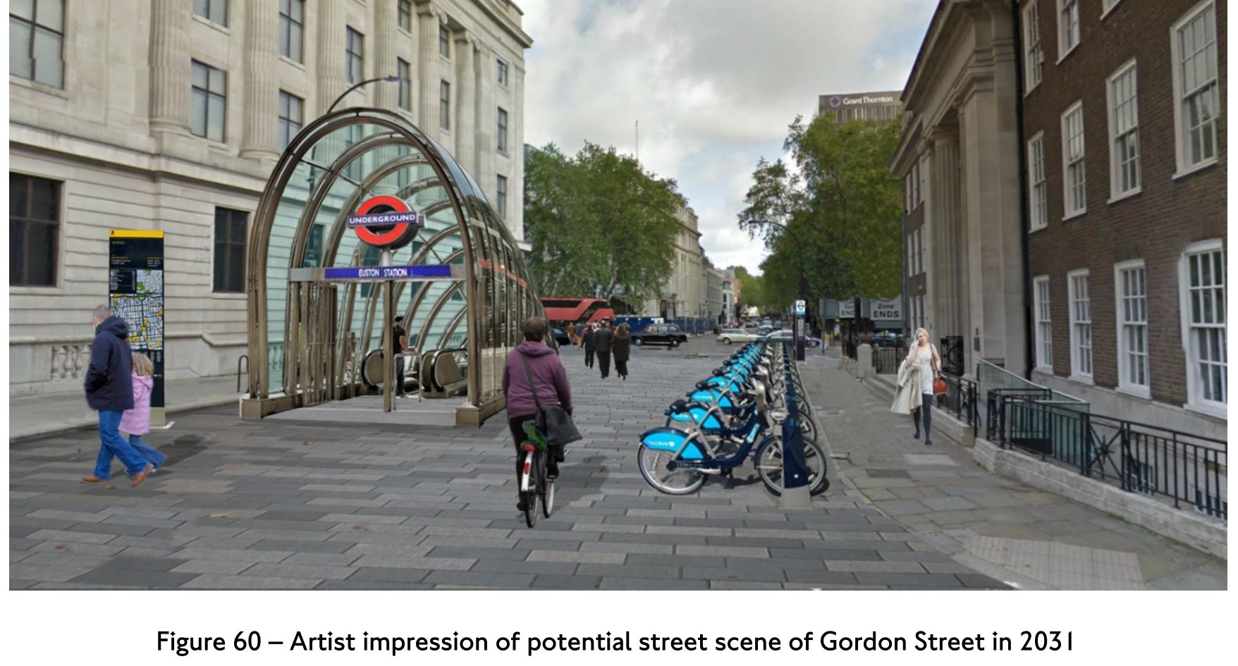
The new Gordon Street entrance appears to be opposite the porticoed building, which is part of University College London.
- The view is looking North, like the first three of my pictures.
- Gordon Street appears to be at least part-pedestrianised.
- Escalators are visible.
It looks to be a London version of Bilbao’s fosteritos.


Fosteritos are named after Norman Foster, as he or his practice designed the Bilbao Metro.
- The escalators in Bilbao are longer than would be needed at Gordon Street.
- I don’t think that fitting in a slimline lift would be difficult.
I like the fosterito concept and I feel a similar approach could be used to add step-free access to a lot of stations on the London Underground.
The Design Of The Updated Euston Underground Station
Ian showed this visualisation of the updated Euston Underground station.
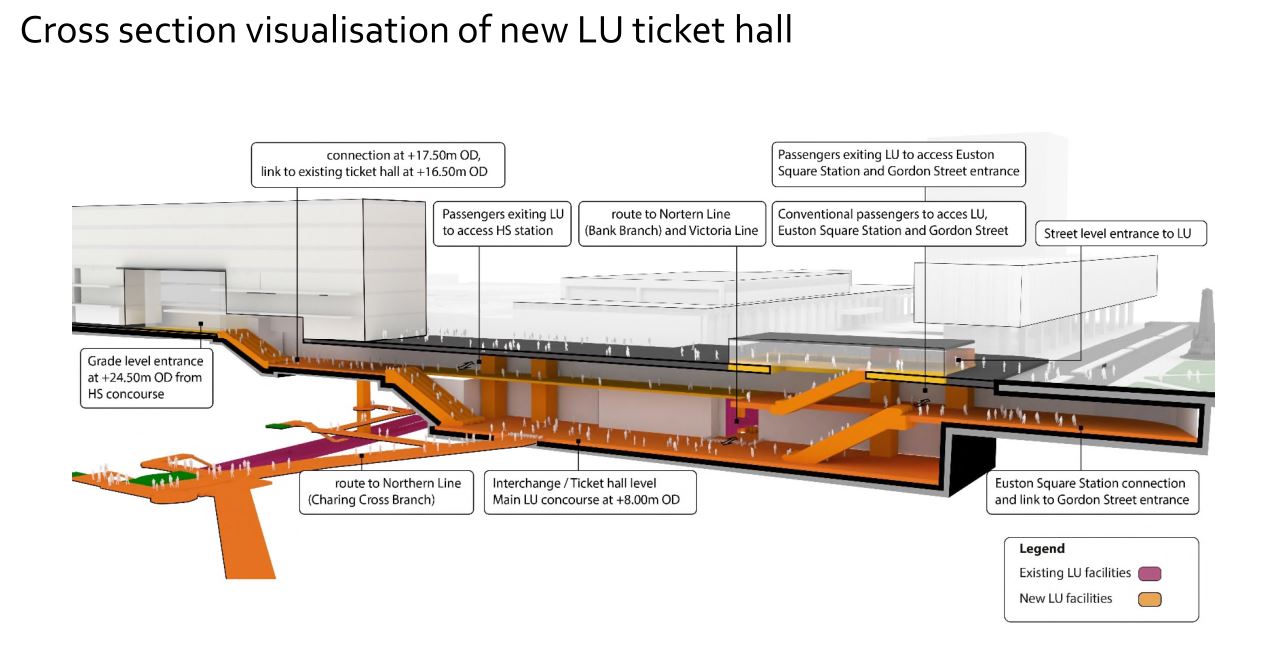
At a first look, it appears to be a very similar concept to the entrance to the Underground in front of St. Pancras station.
Click on the image to show it large and you can pick out the following.
- West is to the left and East is right.
- Much of the construction appears to replace the original car park and taxi rank.
- The upper level looks like where passengers enter and leave the station.
- The subway to Euston Square station and the new Gordon Street entrance joins to the upper level towards the Eastern end.
- There is grade access between the upper level and the High Speed Two concourse.
- There are lots of escalators to travel between levels. The square orange columns could be lift towers.
- The lower level is the Interchange/Ticket Hall level.
- The lower level is not much higher than the Charing Cross branch of the Northern Line.
- The design seems to make clever use of levels to make changing easier.
- The access between the lower level and the Charing Cross branch of the Northern Line at the Western end of the station, appears to be comprehensive and step-free.
- The access between the lower level and the Victoria Line and the Bank branch of the Northern Line, appears to use the current route, which will probably be upgraded to be fully step-free.
This second image shows the design from above the platforms of the convention section of Euston station.
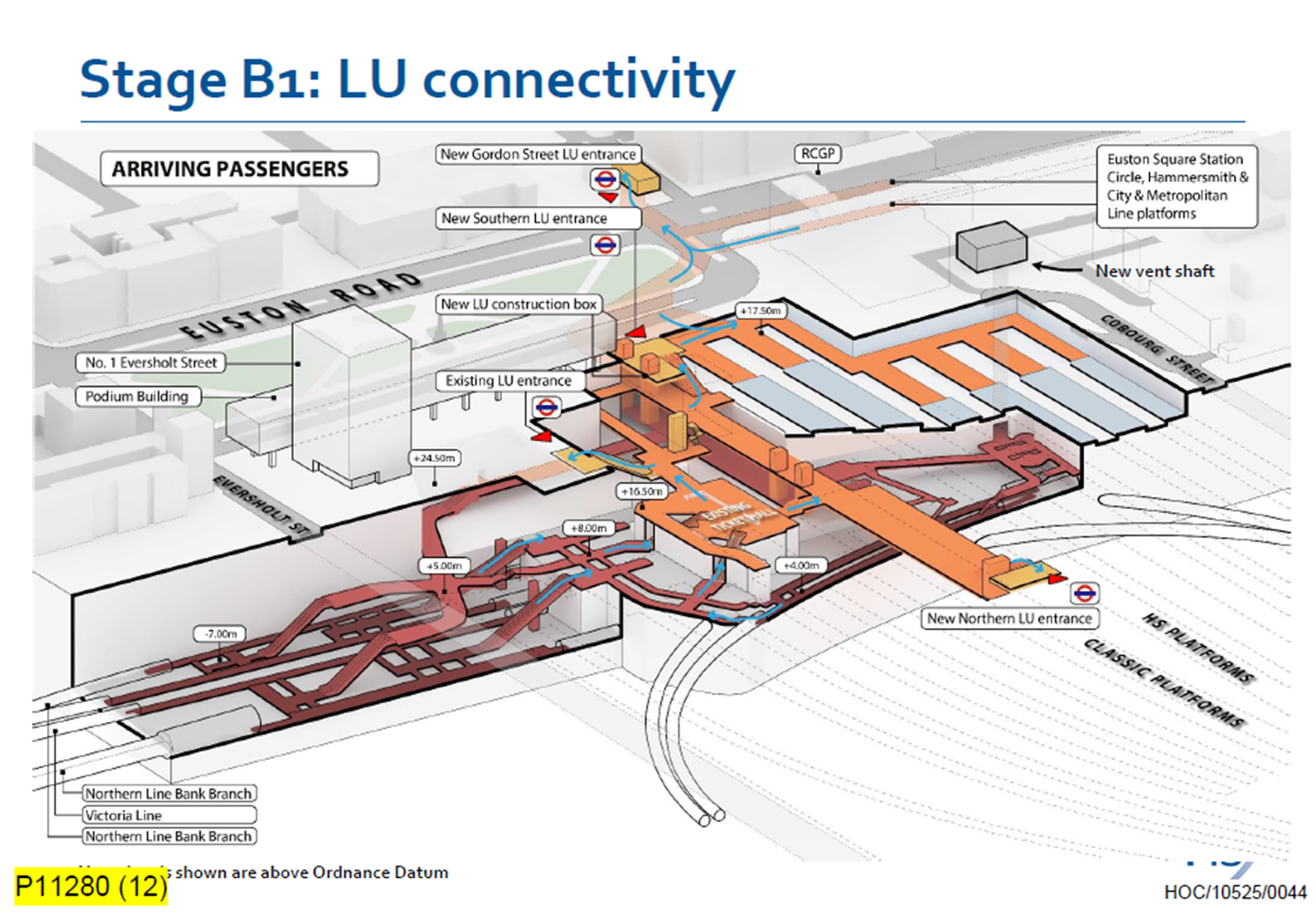
Click on the image to show it large and you can pick out the following.
- The complicated passages, escalators and lifts of the existing four platforms serving the Bank branch of the Northern Line and the Victoria Line.
- The cross passage connecting these lines to the platforms of the Charing Cross branch of the Northern Line.
- The two up and two down escalators leading to the existing ticket hall.
- The Charing Cross branch of the Northern Line curving in and away from the station. See the earlier map of the Underground lines.
- The eleven High Speed platforms on the West side of the station.
- The thirteen Classic platforms on the East side of the station.
- The new Northern entrance to the Underground between the two sets of platforms. How convenient!
- There appears to be a wide passage between the Northern and Southern entrances, with connections to the lines branching off.
- The subway to the new Gordon Street entrance is shown at the top of the image.
The design seems to have separated access to the two branches of the Northern line, by creating a new high-capacity route to the Charing Cross branch.
I also think, that the design allows the station to be built without disrupting passengers using the Underground and the current Euston station.
- A large hole for the station can be excavated, without touching existing access.
- It could then be fitted out section by section.
- Once the new access to the Charing Cross branch of the Northern Line is complete, the current access to the Northern and Victoria Lines can be refurbished.
Arriving At Euston
Imagine you are a passenger arriving from the North, who knows the Underground line, you need to take, you would then enter the Underground station using the new Northern entrance.
- For the Bank branch of the Northern Line or the Victoria Line, you would go through the existing ticket hall and down the escalators, much as you do now! Except that you’d enter the ticket hall on the other side from the East side of the passageway connecting the two entrances. New lifts appear to be shown.
- For the Charing Cross branch of the Northern Line, you would take the passages, lifts and escalators on the West side of the passageway connecting the two entrances.
- If you wanted the sub-surface lines, you would just keep going and take the new subway, which connects to the Eastern ends of the platforms at Euston Square station.
It will certainly do me fine, if I arrive at Euston, as I’ll walk through the subway and get in the front of any Eastbound train for Moorgate station, where being in the front is convenient for the exit and the nearby bus stop to my home.
This route will surely be one of the ways arriving passengers at Euston will get Crossrail to Abbey Wood, Canary Wharf and Shenfield stations. In Crossrail – Northern – Northern City Interchange At Moorgate Station, I show some visualisations of Moorgate station and the connectivity.
Conclusion
I certainly think, that the new Underground station is a good design.
Rail Solar Project Seen As Stepping Stone For Renewables
The title of this post is the same as that of this article on Engineering & Technology.
This is the introductory paragraph.
A British solar power company is working on technology that could enable railways all over the world to be powered by renewable energy, with South Wales seen as a likely testbed for the equipment.
Riding Sunbeams is developing its technology to see if it can be part of the electrification of the South Wales Metro.
Some relevant points from the article.
- Their test installation at Aldershot, which is rated at 37 kW, is quite small.
- The Aldershot system is already delivering power to trains.
- The Welsh Government are aiming for the South Wales Metro to be powered by renewable energy, of which 50 % is generated in Wales.
- There could be export possibilities for the technology.
Note that the article gives an interesting insight into the various equipment needed to power railway electrification.
Manchester Piccadilly ‘Super Hub’ Proposed
The title of this post is the same as that of this article on Rail Technology Magazine.
This is the introductory sentence.
A Manchester Piccadilly ‘super hub’ has been proposed as part of the High Speed North rail project.
And these two paragraphs lay out the proposed design.
To create the super hub, the report suggests a new tunnel from Ordsall into Manchester Piccadilly from the west, which could connect to High Speed 2 (HS2) and Northern Powerhouse Rail (NPR).
Fast trains from Chester and North Wales, Liverpool, Blackpool, Barrow and Glasgow could travel through the super hub with services emerging eastwards and across the Pennines to Leeds/Bradford, Sheffield, Hull, York and Newcastle.
Five years ago, I wrote Whither HS2 And HS3?, which argued for greater integration of the two routes and more tunnelled stations under major cities to build High Speed Two and Northern Powerhouse Rail with less disruption.
Part of that post was deliberately over the top, but it seems that others have been thinking in a similar way.
Last year, I wrote Changes Signalled For HS2 Route In North, which was an attempt to add detail to this report on the Transport for the North web site, which is entitled At A Glance – Northern Powerhouse Rail.
The proposed Manchester Piccadilly ‘Super Hub’ fits very well with the Transport for the North report.
- The station, could have entrances and exits were all over Manchester City Centre
- The main platforms could be long East-West through platforms, that would have direct tunnelled approaches from both directions.
- There could also be terminating platforms to take services from North Wales, Blackpool, Barrow and Glasgow.
- According to the Wikipedia entry for High Speed Two, the Western tunnel would be 7.5 miles long and link Manchester Piccadilly and Manchester Airport stations at speeds of up to 142 mph.
- As a High Speed Two size tunnel will be needed on the Eastern approach, if High Speed Two trains eventually use the route, could this tunnel extend for perhaps five miles with speeds of up to 142 mph, to speed up journey times?
- Journey times between Manchester Piccadilly and Manchester Airport stations could be under four minutes.
The Manchester Piccadilly ‘Super Hub’, High Speed Two And Liverpool
This clip of a map from the Transport for the North report shows a schematic of the current and possible rail links in the area.

High Speed Two would appear to come North and split into two routes.
- One continues North to join the existing West Coast Main Line just South of Wigan.
- Another goes through Crewe station.
North of Crewe, the two routes join and then split into three at the Junction labelled 6.
- To Warrington and Liverpool
- To Wigan, Preston and Scotland
- To Manchester Airport and Manchester.
A second Junction labelled 5, allows Northern Powerhouse Rail trains to run Liverpool-Warrington-Manchester Airport-Manchester.
The Transport for the North report, also says the following.
- There could be a new Warrington South Parkway station.
- Six trains per hour (tph) between Liverpool and Manchester via Warrington are planned.
- Journey times will be 26 minutes.
Will a Liverpool and Manchester time of 26 minutes be possible with two stops?
- I estimate Liverpool and Manchester will be a distance of 43 miles.
- As the will be a newly-built railway high speed railway, I suspect it will be at least a 125 mph line between Liverpool and Manchester Airport.
- But it is perfected feasible, that this section could be designed for speeds up to 140 mph or even the High Speed Two speed of 186 mph.
- TransPennine Express‘s current Class 802 trains, can run at up to 140 mph, so could take advantage of the higher speed.
- In addition, the Wikipedia entry for High Speed Two says that trains will use the Manchester Airport to Manchester City Centre tunnel at speeds of up to 142 mph.
Calculating journey times for various average speeds, including the two stops at Warrington South Parkway and Manchester Airport stations gives the following.
- 100 mph – 26 minutes
- 125 mph – 21 minutes
- 140 mph – 18 minutes
If the Liverpool and Manchester Airport section were to be built to High Speed Two standards, I can see a very comfortable Liverpool and Manchester time of under twenty minutes.
The Twenty-First Century will finally get a modern and fast Liverpool and Manchester Railway.
Going East From The Manchester Piccadilly ‘Super Hub’
The principle long-distance destinations to the East of Manchester Piccadilly station use one of two routes.
The Huddersfield Line to Leeds and beyond.
The Hope Valley Line to Sheffield and beyond.
Both routes leave the Manchester Branch of the West Coast Man Line out of Manchester Piccadilly station at Ardwick Junction.
This Google Map shows Ardwick Junction, Ardwick station and the Siemens Train Care Facility.
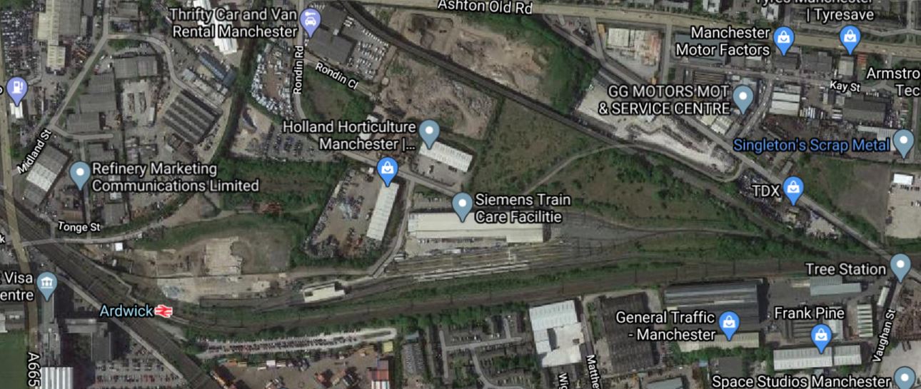
It would appear that the Eastern portal of the tunnels that lead to the proposed underground platforms of the Manchester Piccadilly ‘Super-Hub’ could emerge in this area.
Note.
- Ardwick station is about a mile from Manchester Piccadilly station.
- The Sheffield and Leeds routes split about a mile to the East of Ardwick station.
- The large site of the Train Care Facility, could surely be used for the tunnel portal.
The Transport for the North report says this about the services to the East from Manchester.
- Sic tph between Manchester and Leeds are planned.
- Four tph between Manchester and Sheffield are planned.
Ten tph through the underground platforms is surely possible, when Crossrail will handle 24 tph with full digital signalling.
A Manchester And Leeds High Speed Line
This clip of a map from the Transport for the North report shows a schematic of the rail links to the East of Manchester.
Two alternative routes are proposed between Manchester and Leeds.
- The black route would be created by upgrading the Huddersfield Line.
- The yellow route would be a new route via Bradford.
The Transport for the North report says this about the Leeds-Manchester service.
- There will be six tph.
- The journey will take 25 minutes.
In Is There Going To Be Full Electrification Between Leeds And Huddersfield?, I detailed Network Rail’s £2.9 billion proposal to upgrade the existing route between Huddersfield and Leeds. This is the black route.
If this project results in the full electrification between Leeds and Hudderfield, the Leeds and Manchester route will have these characteristics.
- It will be about forty-two miles long
- All except the sixteen mile section between Stalybridge and Huddersfield is electrified or is planned to be so.
- Network Rail have published plans to upgrade Huddersfield station.
- The section between Huddersfield and Dewbury will be upgraded to four tracks.
- The approach to the underground platforms at Manchester Piccadilly station could be in a two-mile 100 mph tunnel.
- Twenty-five minutes between Leeds and Manchester will need an average speed of 100 mph.
I don’t think it is unreasonable to assume that with a few other improvements, that the twenty-five minute time between Leeds and Manchester is possible.
New 140 mph Trains Will Be Needed
Consider a Blackpool and Leeds service via Preston, Wigan North Western, Warrington, Manchester Airport, Manchester and Huddersfield.
- It could be a fully-electrified route, if between Stalybridge and Huddersfield were to be electrified.
- Much of the route would be cleared for at least 140 mph running including the West Coast Main Line and the new route between Warrington and Manchester Piccadilly via Manchester Airport.
- Some sections of the route would allow more than 140 mph, but most would be 140 mph or less.
Without doubt, trains capable of running at 140 mph would be needed to make full use of the operating speeds available.
Is The New Routemaster A Better Bus For COVID-19?
I went to the Angel today and rode on a New Routemaster.
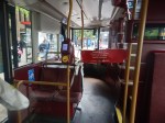


It almost seemed it was a bus designed for social distancing.
- I sat in one of the sets of four seats on the lower deck, by myself.
- The other set, also had a single occupant.
- The driver is safely behind a barrier and two metres from passengers.
- Entry and exit is by rear and centre doors only.
- The buses were designed for entry and exit at all doors.
I’d certainly be happy to travel on one of these buses.
An Inappropriate Advert
I didn’t think that this taxi-advert was in good taste.
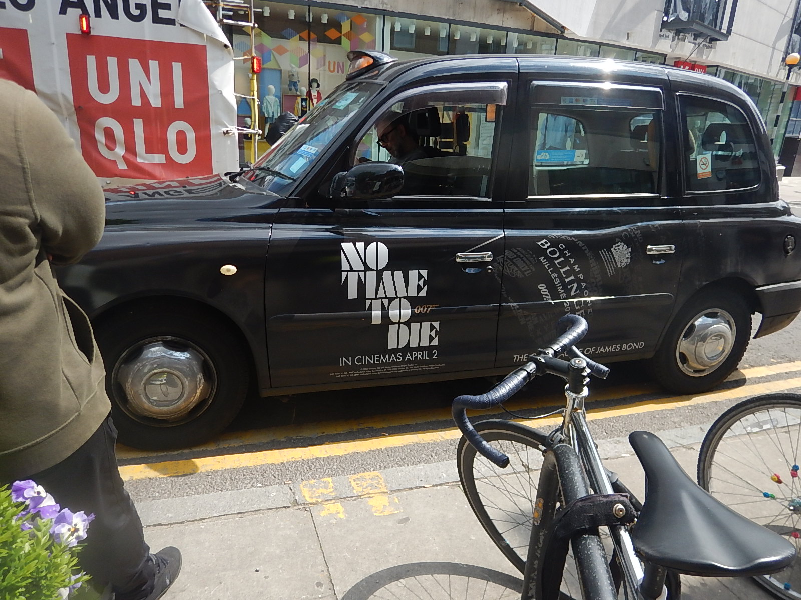
No Time To Die has been put back to the 12th of November.
Plan Submitted For £18.6 Million Station At Soham
The title of this post, is the same as that of this article on Rail Magazine.
The new Soham station appears to be simple.
- A single 102 metre long platform, that will be able to handle a four-car Class 755 train.
- A car-park. Fifty spaces is mentioned on Wikipedia.
- Trains on Greater Anglia‘s two-hourly service between Ipswich and Peterborough service will call. This service is planned to go hourly, with some services extended to Colchester.
- The picture in the article shows a bridge.
- Opening could be in Spring 2022.
I’ve read somewhere that the station will have provision for adding a second platform.
- Looking at the maps of the railway through Soham, it is double-track at the Southern end of the village and single-track at the Northern end.
- The single track section, which reaches as far as Ely, will possibly be doubled before 2030.
- East West Rail are also proposing a new A14 Parkway station at Chippenham Junction, which is close to both the A14 and the A11. I wrote about this in East West Rail Makes ‘Powerful Case’ For Direct Services From Ipswich And Norwich To Oxford.
- The Mayor of Cambridge has plans for a direct service between the new Soham station and Cambridge.
It’ll all be happening in this part of East Anglia. Most is driven by the expansion and success of Cambridge.
It’s all a bit different to the dark days of the Second World War, when the town suffered from the Soham Rail Disaster.
Will there be a memorial at the new station?
A14 Parkway Station
This report on the East-West Rail web site is entitled Eastern Section Prospectus and gives full details of their proposals for the section of East West Rail to the East of Cambridge.
The report recommends building a new station at Chippenham Junction, which is to the East of Newmarket, close to the junction of the A11 and the A14 . The station is referred to in the report as A14 Parkway station.
This Google Map shows the location of the proposed station.
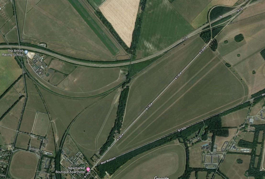
Note.
- The A14 going across the top of the map.
- The junction between the A14 and the A11 in the top-right corner.
- The triangular Chippenham Junction, pointing North to Ely, South to Newmarket and East to Bury St. Edmunds and Ipswich.
Having lived in that area for nearly thirty years, I believe that this is a much-needed station.
- Stations in the area, with the exception of Cambridge North are short of car parking.
- There would be two trains per hour (tph) to/from Bury St. Edmunds and Ipswich.
- There would be one tph to Cambridge, Cambridge North, Cambridge South , Ely, Peterborough and the new Soham station.
I suspect that there could be shuttle trains to provide extra services to Cambridge and Ely.
A shuttle train could run between A14 Parkway, Cambridge South, Ely, Soham and back to A14 Parkway.
- The service might be arranged so that trains reverse at Cambridge South, Ely and A14 Parkway stations.
- As an alternative trains could reverse at Bury St. Edmunds instead of A14 Parkway.
- Trains would call at all intermediate stations.
I believe that if the A14 Parkway station were to be built, that there would be no need to rebuild the Western track of Chippenham Junction to enable services between Cambridge and Soham via Newmarket.
Hydrogen House Is ‘Greenest In Europe’
The title of this post is the same as that of this article in The Times.
This is the introductory paragraph.
A hydrogen-powered house that is off-grid and said to be the first of its kind in Europe is being built by a family in Devon.
These are some features.
- Solar panels
- Hydrogen from electrolysis.
- Hydrogen storage
- Hydrogen boiler
- Water from a borehole
- Own sewage plant
- Air source heat pump.
The article says that “Any spare hydrogen can power the hydrogen cars they plan to buy”
This sounds like my ideal house!
Highview Power And Railway Electrification
In Encore Joins Highview To Co-Develop Liquid Air Energy Storage System In Vermont, I gave brief notes about a proposed Highview Power CRYOBattery in Vermont.
- The system will supply 50 MW for eight hours.
- The total capacity will be 400 MWh.
Other articles have suggested, that the system could be built on the site of a demolished coal-fired power station, which still has a good connection to the electricity grid.
In other words, I believe that a CRYOBattery can be considered to be a small 50 MW power station.
- It could be charged by local excess renewable energy during the day.
- It could be charged by excess renewal energy from the electricity grid during the night, when there can be large amounts of wind energy, that needs a home.
- Intelligent control systems, would balance the output of the CRYOBattery to the needs of the electricity grid.
It would be used in very much the same way as gas-turbine power-stations are used in electricity grids all over the world.
The Braybrooke Feeder Station
The National Grid is providing a feeder station at Braybrooke to support the Midland Main Line electrification.
This page on the Harbough Rail Users site is entitled Electrification Substation Plan for Braybrooke.
It gives this description of the sub-station.
Electrification of part of the Midland Main Line has moved a tentative step closer with the plans being prepared by National Grid for a feeder substation at Braybrooke, just outside Market Harborough. The location is where a high-voltage National Grid power-line crosses over the railway and the plan is for a substation and associated equipment plus an access road from the A6. The substation is due to be completed by October 2020 and is intended to feed the power supply for the Corby line pending electrification of the main line through Market Harborough.
This Google Map shows the rough area, where it will be located.
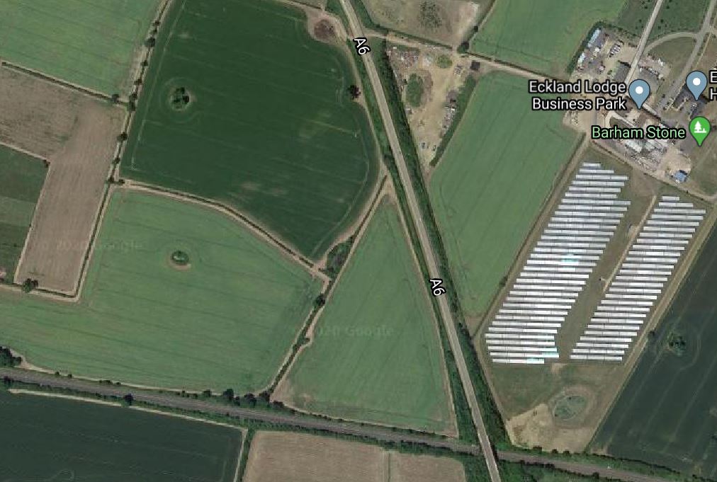
Note.
- The A6 crossing the Midland Main Line.
- The solar farm in the South-facing field, which has a 3MW capacity, according to the Eckland Lodge Business Park web site.
- Various planning documents say the transformers on the substation will be 400/25 kV units.
- This means that the power-line in the area must be a 400 kV.
Unfortunately, I can’t pick out the line of 400 kV pylons marching across the countryside. But they are rather large.
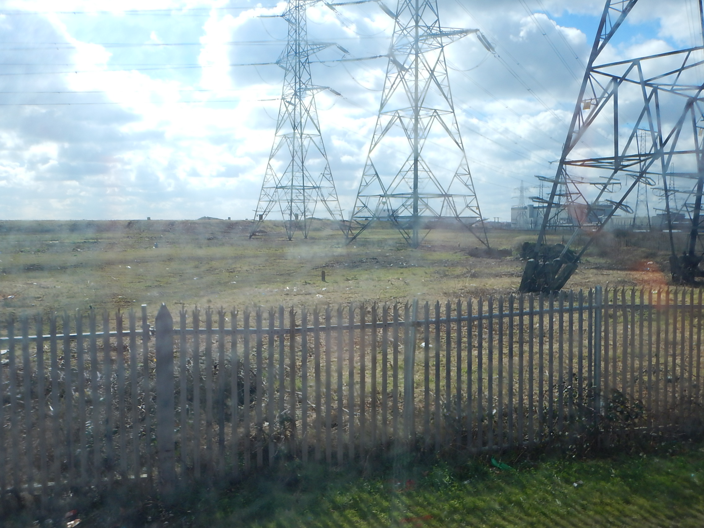
The pictures show a group of 400 kV pylons near Barking.
- The Midland Main Line at Braybrooke certainly seems to be getting a solid supply of electricity.
- It was originally planned, that the electrification would go all the way, but it was cut back to Kettering and Corby a couple of years ago.
- But to power, the electrification to Corby, it is being extended all the way to Braybrooke, so that the electrification can act as a giant extension lead for the Corby Branch Line.
The page on the Harborough Rail Users Site says this.
The Braybrooke substation is still planned, however, and the DfT has advised that the bi-mode trains will be able to switch power mode at speed. They would therefore be able to continue running electrically north from Kettering as far as Braybrooke before ‘pan down’
It would appear, that the end of the electrification will be at Braybrooke, but the sub-station seems to have enough power to extend the electrification further North if that is ever planned.
I also think, that is rather an efficient and affordable solution, with very little modification required to the existing electricity network.
But not all electricity feeds to railway electrification have a convenient 400 kV line at a handy site for installing all the needed transformers and other electrical gubbins.
How Much Power Will Needed To Be Supplied At Braybrooke?
This can probably be dismissed as the roughest or rough calculations, but the answer shows the order of magnitude of the power involved.
Consider.
- Braybrooke must be sized for full electrification of the Midland Main Line.
- Braybrooke will have to power trains North of Bedford.
- If there is full electrification of the Midland Main Line, it will probably have to power trains as far North as East Midlands Parkway station, where there is a massive power station.
- Trains between Bedford and Market Harborough take thirty minutes.
- Trains between Bedford and Corby take around thirty minutes.
- Four trains per hour (tph) run between Bedford and Market Harborough in both directions.
- The system must be sized to handle two tph between Bedford and Corby in both directions.
- The power output of each Class 360 train, that will be used on the Corby route is 1,550 kW, so a twelve-car set will need 4.65 MW.
- I can’t find the power output of a Class 810 train, but an InterCity 125 with similar performance has 3.4 MW.
- A Class 88 bi-mode locomotive has a power output of 4 MW when using the electrification.
I estimate that Braybrooke could have to support at least a dozen trains at busy times, each of which could need 4 MW.
Until someone gives me the correct figure, I reckon that Braybrooke has a capacity to supply 50 MW for trains on the Midland Main Line.
A Highview Power system as proposed for Vermont, would have enough power, but would need a lot more storage or perhaps local wind or solar farms, to give it a regular charging.
Riding Sunbeams
Riding Sunbeams are a company, who use solar power to provide the electricity for railway electrification.
I’ll let their video explain what they do.
It’s a company with an idea, that ticks a lot of boxes, but would it be able to provide enough power for a busy electrified main line? And what happens on a series of rainy or just plain dull days?
Highview Power
Could a Highview Power energy storage system be used?
- To store electricity from local or grid electrical sources.
- To power the local electrification.
If required, it could be topped up by affordable overnight electricity, that is generated by wind power.
The Highview Power system could also be sized to support the local electricity grid and local solar and wind farms.
Conclusion
I think that Riding Sunbeams and Highview Power should be talking to each other.
To Revive Economy, Think Infrastructure
The title of this post is the same as that of this article on CommonWealth.
This is the sub-title.
It worked in the Great Recession and it can work now.
The author is talking about Massachusetts in 2008, but I’m sure it would work in the UK and other countries in 2020.
Projects I would bring forward in the UK.
- Build lots of wind farms, both onshore and offshore.
- Build energy storage. I would go for Highview Power.
- Use wind energy to generate hydrogen for industrial processes. ITM Power in Rotherham, have the technology.
- Build a refuelling network for hydrogen-powered cars, buses, trucks and other vehicles.
- Add new rail stations to the network, where needed.
- Update all possible rail, tram, light rail and Underground stations so they are step-free.
- Build the electrified Huddersfield and Leeds upgrade to the TransPennine Route.
- Expand the Blackpool Tram, the Edinburgh Tram, the Manchester Metrolink, Merseyrail, the Nottingham Express Transit, the Sheffield Supertram, the Tyne and Wear Metro and the West Midlands Metro.
- Extend the Docklands Light Railway West to Charing Cross, Euston, St. Pancras and Victoria.
I would setup a construction pipeline, so all areas of the country got a share of the new infrastructure.
We must be bold.
