TfL Closes 40 Tube Stations, Suspends The Night Tube, Fewer Trains And Buses Next Week
Th title of this post is the same as that of this article on Ian Visits.
Ian gives this list of stations that could close.
Bakerloo Line
- Lambeth North
- Regents Park
- Warwick Avenue
- Kilburn Park
- Charing Cross
Central Line
- Holland Park
- Queensway
- Lancaster Gate
- Chancery Lane
- Redbridge
Circle Line
- Bayswater
- Great Portland Street
- Barbican
District Line
- Bow Road
- Stepney Green
- Mansion House
- Temple
- St James’s Park
- Gloucester Road
Jubilee Line
- Swiss Cottage
- St John’s Wood
- Bermondsey
- Southwark
Northern Line
- Tuffnell Park
- Chalk Farm
- Mornington Crescent
- Goodge Street
- Borough
- Clapham South
- Tooting Bec
- South Wimbledon
- Hampstead
Piccadilly Line
- Caledonian Road
- Arsenal
- Covent Garden
- Hyde Park Corner
- Bounds Green
- Manor House
Victoria Line
- Pimlico
- Blackhorse Road
The general feeling in the comments on Ian’s site, is that they are stations, where they are lightly used or the design could increase the rate of infection.
Reopening Of Darlaston And Willenhall Train Stations Moves Closer
The title of this post is the same as that of this article on the Wolverhampton Express And Star.
This is the introductory paragraph.
A bid to reopen two railway stations after more than half a century has taken a major step forward after planning applications were formally submitted.
The two stations are Willenhall Bilston Street and Darlaston James Bridge on the Walsall–Wolverhampton Line.
- The route is electrified, as it is used as a diversion route for the West Coast Main Line.
- There will be an hourly service between Wolverhampton and Walsall.
- There will be a second hourly service between Wolverhampton and Birmingham via Willenhall, Darlaston and Tame Bridge Parkway stations.
- It is planned that services will open in December 2021.
It appears that funding is in place from Whitehall.
Conclusion
Will much work need to be done to get these two station projects shovel-ready?
If not, why not get going?
First Passenger Train In 80 Years Runs On Camp Hill Line
The title of this post is the same as that of this article on Rail Technology Magazine.
These two paragraphs described the route, that the train took on the Camp Hill Line.
On Monday morning a train carrying the Mayor, West Midlands Railway’s customer experience director Jonny Wiseman and other representatives from across the rail industry, travelled along the line.
The train followed the route of what would be the re-opened line, stopping at the Moseley, Kings Heath and Hazelwell sites before arriving into Kings Norton, and later returning to Birmingham New Street.
The article has a picture showing the VIPs showing boards indicating the stations at Moseley, Kings Heath and Hazelwell, that will be reopened.
Wikipedia says this under Future for all three stations.
In 2019, the project to re-open the stations at Moseley, Kings Heath and Hazelwell received £15 million in Government funding, with construction due to start in 2020 and aimed for completion in time for the 2022 Commonwealth Games.
£15million seems good value to reopen three stations.
Let’s hope the world has solved the COVID-19 crisis before the 2022 Commonwealth Games.
Trains For The Service
The picture in the article, shows the test service was run by a two-car Class 170 train. This is an ideal train to do the testing, but as the Camp Hill Line is not electrified, self-powered trains will be needed for the passenger service.
West Midlands Trains will have a good selection of self-powered trains with which to run the service.
- They already have a selection of Class 170 and Class 172 Turbostar diesel multiple units in very good condition, which total thirty-seven two-cars and twenty-one three-cars.
- I’m sure Vivarail will pitch diesel-electric or battery-electric versions of their Class 230 trains.
- Alstom will probably pitch the Breeze hydrogen-powered train.
- Porterbrook will probably pitch their proposed Battery/FLEX conversion of Class 350 trains.
I don’t think there will be a problem finding a suitable fleet for this route.
I suspect some form of battery-electric train will be used, as there is lots of 25 KVAC overhead electrification in the Birmingham area, that can be used to charge the batteries.
Battery-electric trains with a range of perhaps forty miles would also open up the possibilities for other electric services for West Midlands Trains.
A Thought On Construction
Because of COVID-19, there will probably be numbers of unemployed in this part of Birmingham, who have skills that could be useful to do the building work.
So should the non-railway related parts of the reopening be accelerated to put money in the pockets of the local unemployed.
Looking At The East West Railway Between Bedford And Cambridge
Updated Post
I have updated this post in June 2021 to add extra information, that has now become available.
The route that has been chosen by East West Railway is Route E.
Route E is described in Wikipedia as follows.
Route E involves running from the existing Bedford station heading north then running to Tempsford where a new station would be built then (bypassing Sandy) the route heads east to Cambourne where a new station would be built. The route then joins an existing line northbound to Cambridge.
These maps show the route between Bedford and Cambridge stations in sections.
Bedford And Tempsford
This map shows the Western section between Bedford and Tempsford.
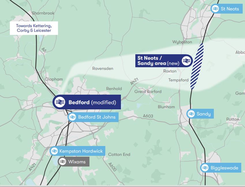
Note.
- Kempston Hardwick and Bedford St. Johns are existing stations on the existing Marston Vale Line, which could substantially be the route of the East West Railway between Bedford and stations to the West like Bletchley, Milton Keynes, Oxford and Reading.
- Bedford station is on the Midland Main Line.
- Wixams station is a proposed station on the Midland Main Line, which also might be served by the East West Railway.
- Biggleswade, Sandy and St. Neots stations are on the East Coast Main Line (ECML).
I’ll now take a quick look at the route through Bedford and the proposed Wixams station.
Bedford Station
Bedford station is served by the following train services.
- It is a terminus for Marston Vale Line services to and from Bletchley station.
- It is a terminus for Thameslink services to and from London St. Pancras International station and the South as far as Brighton.
- East Midlands Railway services between London St. Pancras International station and the East Midlands and Sheffield call at the station.
Midlands Connect are also proposing a service between Bedford and Leeds.
- It would use High Speed Two Classic-Compatible trains.
- This would use High Speed Two to the North of East Midlands Hub station.
- Times would drop between Bedford and Leeds from 140 minutes to 66 minutes.
I wonder, if this service were to be successful, that more services could be run from Bedford to the North.
There would certainly be massive advantages in developing Bedford as a major interchange between the East West Railway and the Midland Main Line.
This Google Map shows Bedford station.
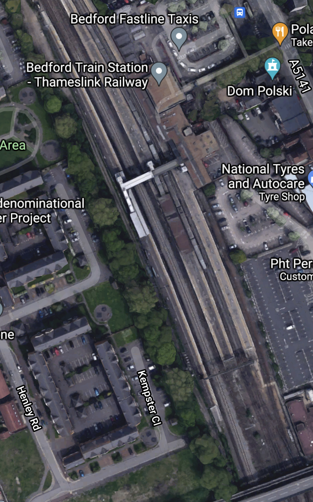
Bedford station currently has five platforms.
- 1a – A bay platform for Marston Vale Line services
- 1 and 2 – Thameslink
- 3 – Southbound East Midlands Railway
- 4 – Northbound East Midlands Railway
Note.
- Platform 1a is about a hundred metres long.
- There is a fast line between Platforms 3 and 4.
- There is space to the West of Platform 4
I can come to these conclusions about Bedford station.
If a new platform is needed to handle more services at the station, there is space to build it.
According to East West Railway Company To Start Second Phase Of Rolling Stock Procurement, three-car trains are to be used by the East West Railway and these can be handled by the current Platform 1a.
As Bedford station is to be rebuilt, any issues can be sorted.
This Google Map shows the area to the North of the station.
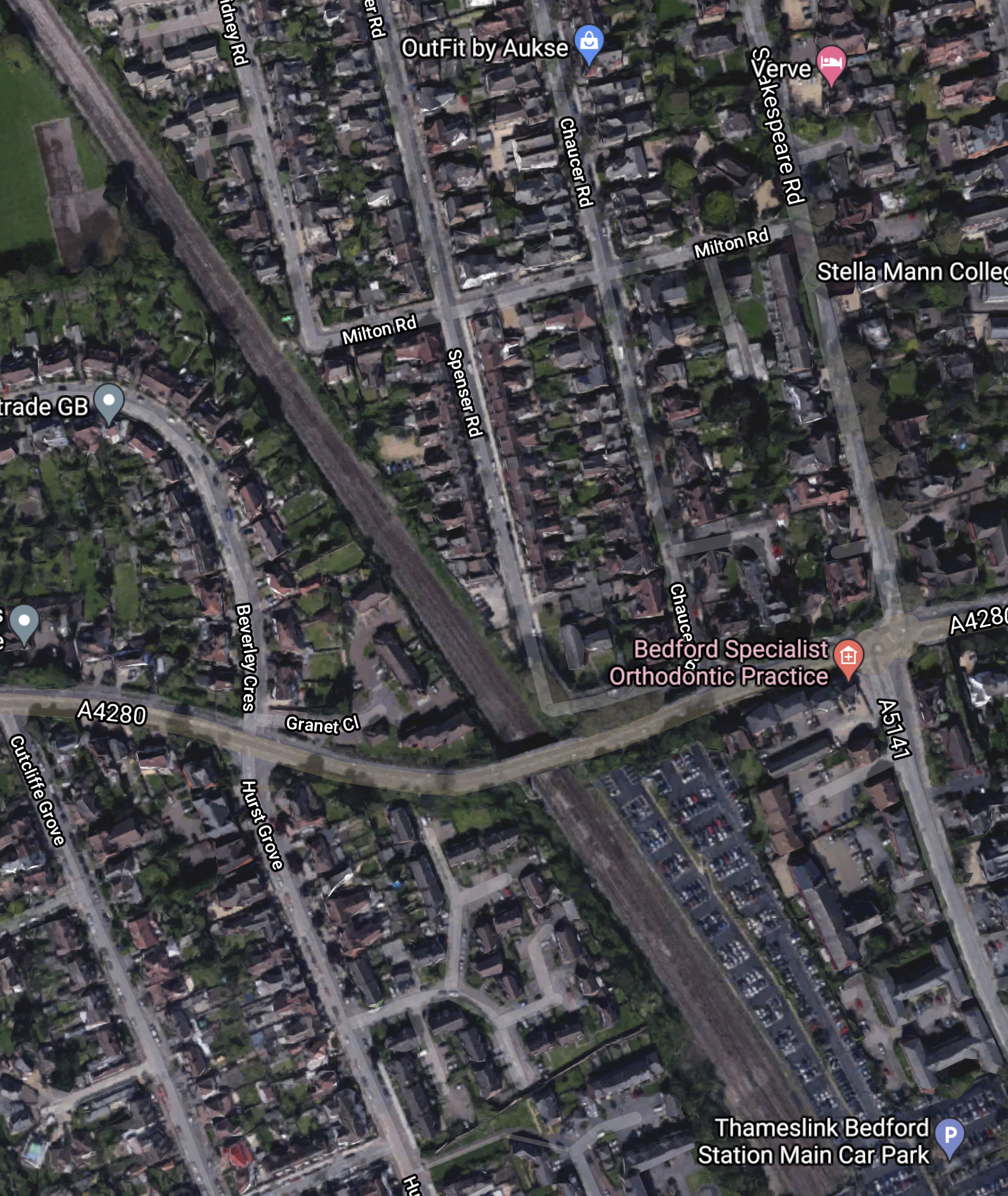
Note that some of the roads to the North-East of the railway are named after poets. This is the Poets area of Bedford.
This article on the BBC is entitled East-West Rail: Bedfordshire Residents Give Their Views On £5bn Scheme and it details the opposition to the route including a section about the Poets area.
EWR Co says it could acquire or demolish 53 properties in the Bromham Road district of Bedford, known as the Poets area.
In addition, a further 16 properties could be demolished between Bedford and Cambridge.
This Google Map shows the Midland Main Line through Bedford.
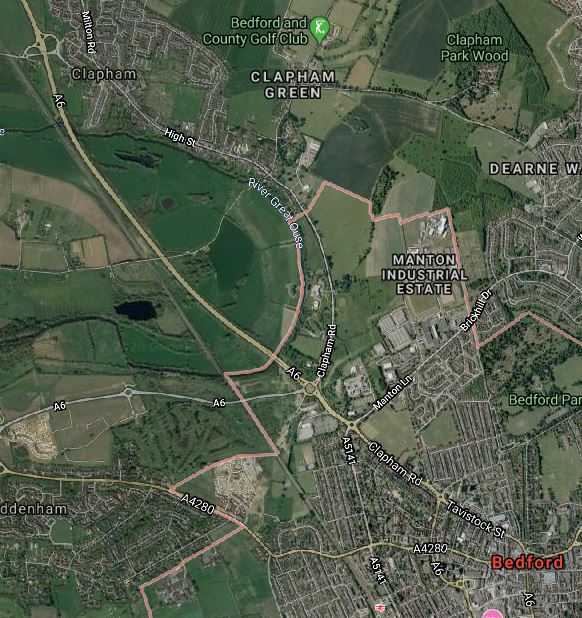
Note.
- Bedford station is at the bottom of the map towards the East.
- The village of Clapham is towards the top of the map.
- The A6 road runs up the Eastern side of the railway.
What I find interesting, is that, to the East of the Midland Main Line between Bedford and Clapham appears to be mainly open farmland.
Is there sufficient space to build a flying junction, so that trains could go between Bedford and Cambridge in a smooth manner? From a quick look at this map, it appears to me that this would be possible.
It might even be possible to build a full triangular junction, North of Bedford, so that trains could go between the East and the Northbound Midland Main Line.
It looks to me to be a very important junction, that gives lots of possibilities for new passenger and freight services.
- Passenger trains between Cambridge and Sheffield via Leicester and Derby.
- Freight trains between Felixstowe and Derby, Nottingham and Sheffield.
- Could the route be used for stone trains between the Peak District and the massive building developments in the City of London?
This ideas would be for starters!
But I do feel that Network Rail have lots of strong reasons to take a North-Easterly route out of Bedford.
But this route is not popular with those that live in the area.
This Google Map shows the area South of Bedford towards the Wixams development.
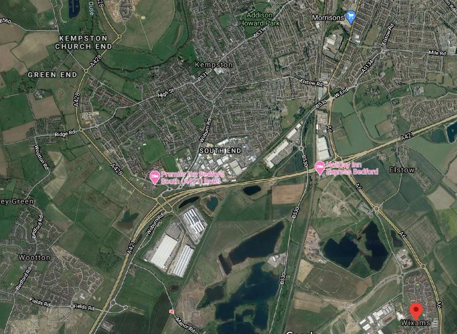
Note.
- The large new village of Wixams is shown by the red arrow.
- Kempston Hardwick station can be picked out to the West of Wixams, close to the bottom of the map.
- The Midland Main Line can be picked out running South between Wixams and Kempston Hardwick.
The area looks like it is ripe for housing and commercial development between all the water.
I can envisage the East West Railway and the Midland Main Line doing the following.
- Sharing tracks through Bedford and a new Wixams station, if that is desired.
- A flying junction would then allow the two routes to split.
- The East West Railway would go West to places like Bletchley, Milton Keynes, Oxford and Reading.
- The Midland Main Line would go South to Luton, London and beyond.
The East West Railway would open up a massive housing development at Wixams with connections to Cambridge, London, Milton Keynes, Oxford and beyond.
It strikes me, that one of the reasons for choosing Route E, is that this is the route, that opens up the Wixams development.
Could A Southern Route Be Used Around Bedford?
It probably could but, if the trains were to serve Bedford they’d need to reverse in Bedford station.
If the East West Railway goes to the North of Bedford, the following is possible.
- East West Railway trains going East could share Platform 4 with Northbound East Midlands Railway services.
- East West Railway trains going West could share Platform 3 with Southbound East Midlands Railway services.
- East West Railway trains going West could also have a cross-platform interchange with Thameslink.
Train operation would be much simpler.
Through Tempsford
This map shows the Western section around Tempsford, where it crosses the ECML.
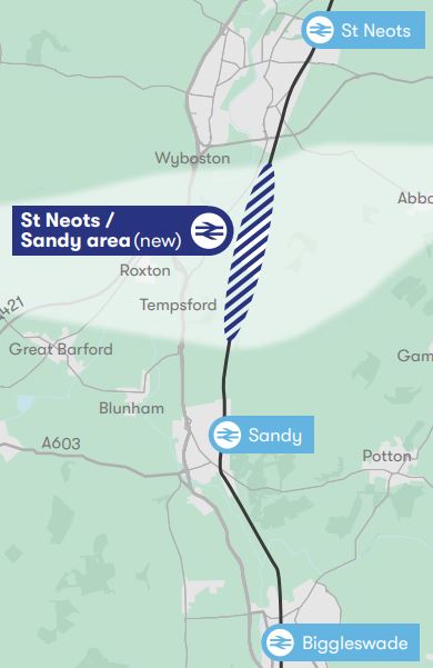
Note.
- Biggleswade, Sandy and St. Neots stations are on the ECML.
- There might be opportunities to improve the section of the ECML in this area.
- The light-coloured East-West band through the new station, is the proposed route of the East West Railway.
This Google Map shows the area North from Sandy.
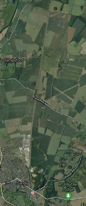
Note.
- Sandy station can be seen at the bottom of the map.
- Tempsford can be seen about three-quarters of the way up the map.
- The ECML runs North-South up the middle of the map.
- The former RAF Tempsford can also be seen on the East side of the ECML.
- One interesting place on the map is the RSPB at Sandy.
Has the route been chosen to the North of Sandy to avoid the RSPB, who might not be in favour of a new railway?
- I could envisage an impressive interchange station at Tempsford, if East West Railway decided to build it.
- The East West Railway and the ECML could cross at right angles.
- Platforms on both routes could be connected by lifts, escalators and stairs.
- There looks like there could be space for lots of car parking.
Alternatively, a full junction could be built so that trains could swap between the two routes. But I suspect this would be too expensive.
The View From St. Neots
This article on the BBC is entitled St Neots: ‘I Think This Could Put Our Town On The Map’.
This is the first paragraph.
For the first time in its 1,000 years of history, St Neots could get its own voice in Parliament as part of a reshuffle of constituency boundaries. What difference could it make for a town that is the largest in Cambridgeshire?
The This in in the title is their own MP.
This is also said about transport links in the town.
he town, which is 45 minutes to London by rail, is getting a new bypass and is also at the centre of the new Cambridge to Oxford east-west rail link.
“There are phenomenal opportunities here for new business, all this development is happening around us,” adds Mr Hughes.
“All the people who used to travel to London – because St Neots is a commuter town – during the pandemic, they’ve opened the door, walked into the town and realised there’s a wonderful bohemia here.
There are also complaints in the article about the lack of jobs.
Surely, if the new station at Tempsford was well-designed and had enough car-parking, some of those commuters could work in Cambridge.
Tempsford And Cambourne
This map shows the central section between Tempsford and Cambourne.
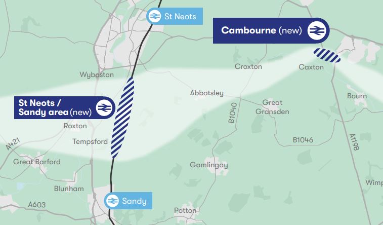
Note.
- Sandy and St. Neots stations are on the ECML.
- The light-coloured East-West band through the new Tempsford and Cambourne stations, is the proposed route of the East West Railway.
This Google Map shows the area between Tempsford and Cambourne.
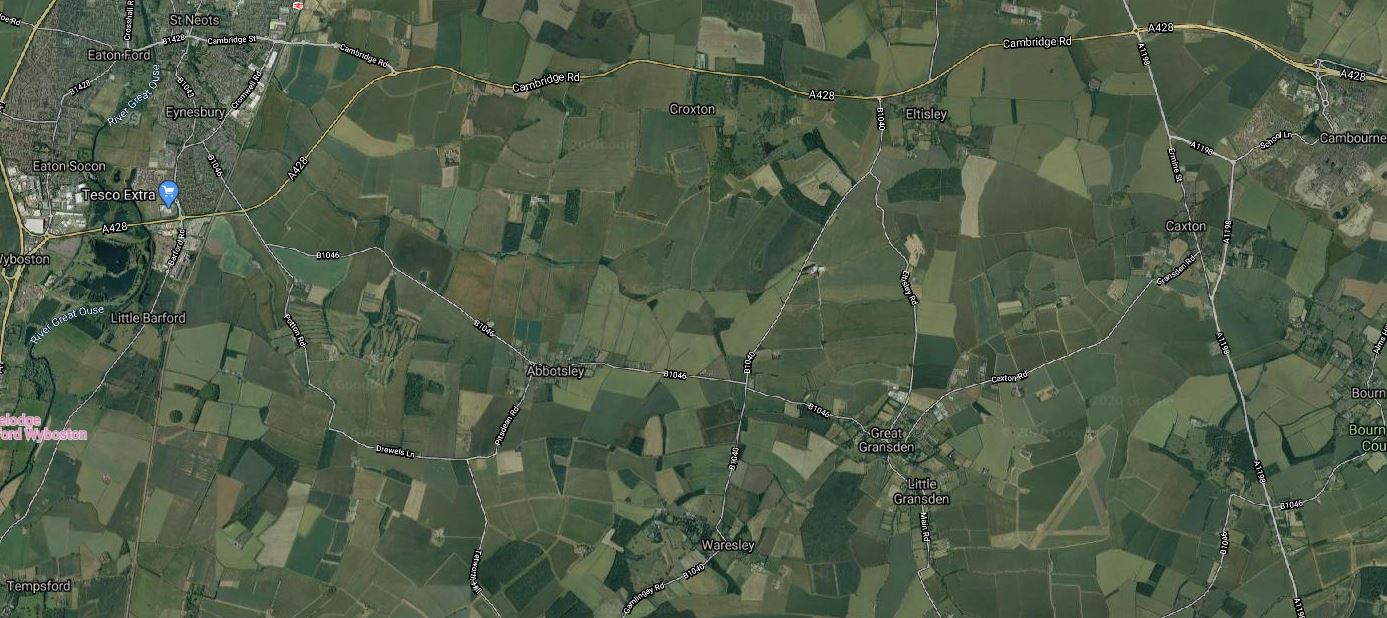
Note.
- Tempsford is in the South-West corner of the map.
- Cambourne is in the North-East corner of the map.
- St. Neots station is in the North-West corner of the map.
It certainly isn’t an area of the country with many important buildings around.
Through Cambourne
This Google Map shows the central section through Cambourne.
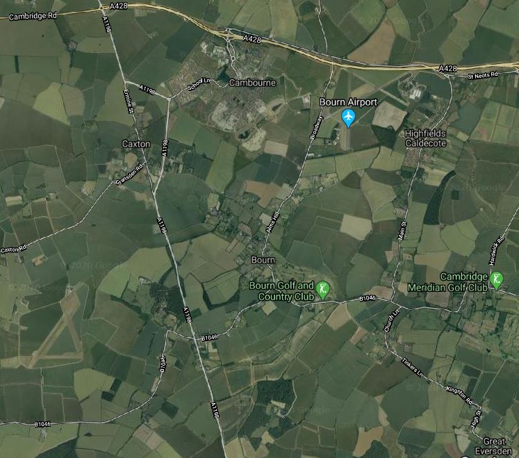
Note.
- The new village of Cambourne by the A428.
- The A1198 road going North-South between Huntingdon and Royston.
- The village of Great Eversden in the South-East corner of the map.
From looking at the various maps and knowing the area well, I suspect the East West Railway will take the following route.
- Approach from the West and cross the A1198 to the North of Caxton.
- Pass South of Cambourne, where a station could be built. The station could be fairly simple, but there is plenty of space, especially if cycling to the train is encouraged.
- Pass North of Bourn and Bourn Golf and Country Club.
- Pass North of Great Eversden and leave the map in the South-East corner.
It looks to be a fairly simple section.
Great Eversden And Cambridge
This Google Map shows the area from Great Eversden to the Trumpington Park-and-Ride, which is served by the Cambridgeshire Guided Busway.
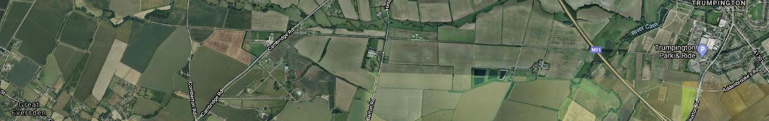
Note.
- Great Eversden is in the South-West corner of the map.
- The M11 runs diagonally across the Eastern end of the map.
- Trumpington is at the Eastern end of the map.
- The track bed of the old Varsity Line is clearly visible.
The question has to be asked, if it would be worthwhile rebuilding this section.
Consider.
- Part of the trackbed is used for the Ryle Telescope.
- Part of the trackbed is used for the Cambridgeshire Guided Busway.
- The route doesn’t serve Addenbrooke’s Hospital.
- Cambridge also has ambitions to extend the Cambridgeshire Guided Busway to Hauxton and create the Cambridge Autonomous Metro, which I wrote about in Consultation On The Cambridge Autonomous Metro.
This map shows the proposed layout of the Cambridgeshire Autonomous Metro.
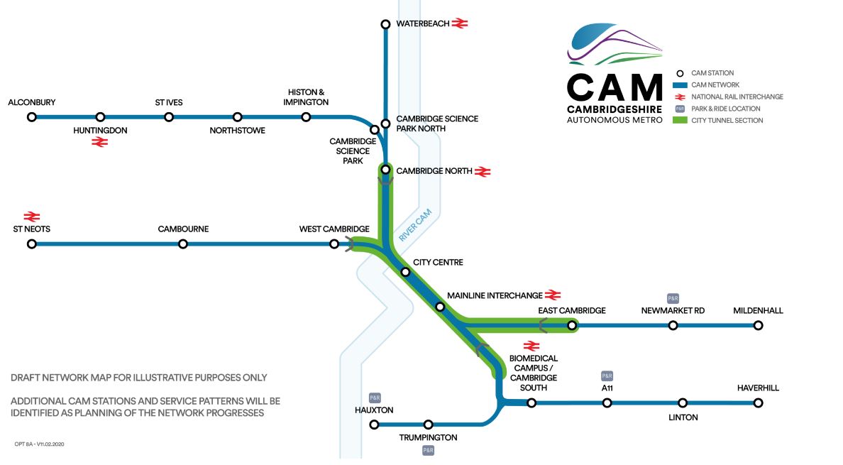
Note.
- The green section will be in tunnel.
- The Trumpington Branch is extended to Hauxton,
This Google Map shows the area to the South West of Cambridge between Hauxton and Addenbrooke’s Hospital.

Note.
- Addenbrooke’s Hospital is in the North-East corner of this map.
- The Trumpington Park-and-Ride is to the East of the M11.
- Shelford station is in the South-East corner of the map.
- The West Anglia Main Line running past the hospital, splits into two, with one branch going West to Royston and Hitchin and the other going South to Harlow and London.
The two maps taken together weave quite a complicated pattern.
The East West Railway and the Cambridge Autonomous Metro could probably be tweaked so that they could both be created.
- The East West Railway could take a slightly more Southerly route and pass to the West of Hauxton to join the Royston and Cambridge Line to get to Cambridge South and Cambridge stations.
- The Cambridge Autonomous Metro would pass over or under the M11 and terminate at a suitable place on the East of Hauxton.
There might even be a solution involving a joint station to the West of the M11
Manchester Piccadilly Through Platforms Become ‘A Station Within A Station’
The title of this post, is the same as that of this article on Railway Gazette.
This was the introductory paragraph.
Following what Network Rail describes as ‘a major rethink’, the two through platforms at Manchester Piccadilly which handle up to 14 trains/h are to be managed independently from the rest of the station.
Measures to be taken include.
-
- A dedicated Customer Service team.
- Better customer information screens.
- An improved satellite lounge with lots of facilities.
- Platforms will be fitted with windbreaks.
- Improved train stopping procedures to cut train dwell times.
Network Rail is also going to run a design contest to see if anybody has any other ideas.
I shall be interested to see how this works out.
First Of Greater Anglia’s Aventra EMUs On Test
The title of this post, is the same as that of this article on Railway Gazette.
This was the introductory paragraph.
Greater Anglia has begun testing the first of the 111 Aventra 25 kV 50 Hz electric multiple-units being supplied by Bombardier Transportation for its London commuter routes.
Hopefully, we’ll be seeing some of these trains in service this year.
A Site For Battery Train Sceptics
I meet and get messages from a lot of people, who are sceptical, that battery-powered trains will ever be a viable alternative to diesel-powered ones.
I have just read this post on Vivarail’s web site, which is entitled Battery Train Update.
It is very open and informative and is very much a must read for anybody interested in the future of railways worldwide or the application of battery-powered trains.
The introductory sentence of the update is very heartening.
Our first production train is in its final build stage and is due to go out on the network – fully approved for passenger service – by the summer.
Provided of course, the COVID-19 situation will allow everybody to travel.
First Order For Mireo Plus B Battery EMUs
The title of this post is the same as that of this article on Railway Gazette.
This is the introductory paragraph.
The Land of Baden-Württemberg’s rolling stock body SFBW has ordered 20 battery-equipped Mireo Plus B electric multiple-units from Siemens Mobility, which will then be responsible for their availability over a 29½-year operating life.
The Siemens Mireo Plus B Battery EMUs appear to have the following specification.
- Ability to use overhead electrification.
- Ability to use battery power for a range of eighty kilometres.
- Two underfloor lithium-ion battery packs.
- Batteries handle regenerative braking.
- 160 kph operating speed.
Delivery is by December 2023.
A Class 755 Train PowerPack Car
The picture shows the PowerPack car of a Class 755 train.
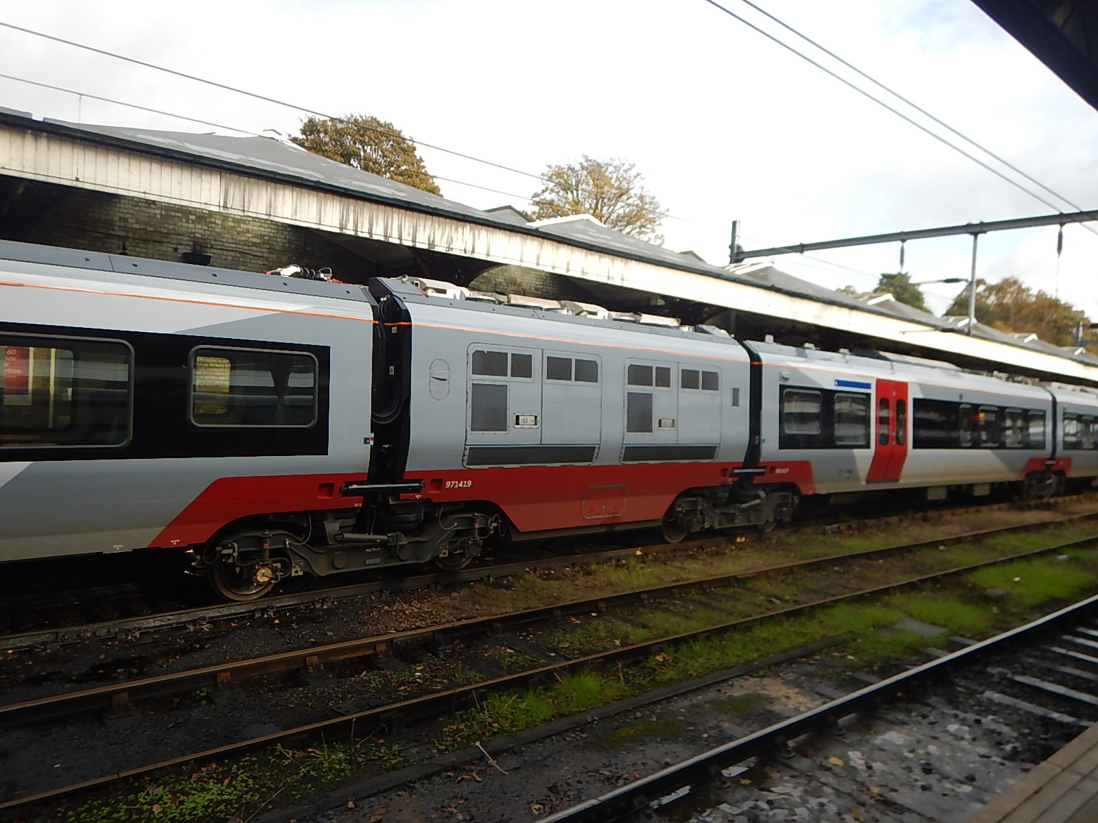
Note.
- The two covers to give access to the two engines on each side of the car.
- The shared Jacobs bogies between the cars.
- The pairs of shock absorbers between cars.
The Jacobs bogies and the shock absorbers are probably used to help give the trains a smooth ride. The Wikipedia entry for Jacobs bogies says this.
Instead of being underneath a piece of rolling stock, Jacobs bogies are placed between two carbody sections. The weight of each car is spread between the Jacobs bogie. This arrangement provides the smooth ride of bogie carriages without the additional weight and drag.
After my half-dozen or so rides in Class 745 and Class 755 trains, I wouldn’t be averse to seeing a lot more of these trains in the UK.
Morden South Station – 24th December 2019
These pictures were taken on the 24th December 2019, at Morden South station.


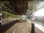


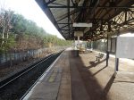
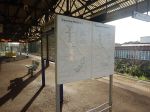

The station is based on an island platform like many on the Sutton Loop Line.
The station doesn’t have step-free access, but I suspect, that a lift could be installed between the tunnel and the island platform.
