National Grid And Emerald AI Announce Strategic Partnership To Demonstrate AI Power Flexibility In The UK
The title of this post, is the same as that of this press release from National Grid.
This is the sub-heading.
National Grid and Emerald AI are partnering to show how AI data centres can support a smarter, more flexible grid.
A UK-first live trial is planned for late 2025 on a grid connected data centre using Emerald AI’s platform.
Targeted for late 2025, the demonstration will use cutting-edge NVIDIA GPUs, to dynamically adjust energy consumption
Increased flexibility of data centre consumption can unlock capacity and accelerate connections to the electricity network.
These three introductory paragraphs indicate how the strategy partnership will work.
National Grid and Emerald AI today announced a strategic partnership to demonstrate how AI data centres can work with the transmission network to adjust their energy use in real time, making better use of existing capacity to support the UK’s growing digital needs.
The partners will deliver a live demonstration in the United Kingdom showcasing Emerald Conductor, an AI-powered system that acts as a smart mediator between the grid and a data centre, supporting flexible management of energy demand. Targeted for late 2025, the demonstration will use cutting-edge NVIDIA GPUs, dynamically adjust energy consumption, and support grid stability.
The electricity transmission network is designed with built-in redundancy to deliver world-class reliability and keep the lights on for customers. Capacity is typically available outside of peak events like hot summer days or cold winter storms, when there’s high demand for cooling and heating. That means, in many cases, there’s room on the existing grid to connect new data centres, if they can temporarily dial down energy usage during periods of peak demand.
Yesterday, there was an article in The Times which was entitled Octopus Energy Prepares Kraken Software Arm for Potential IPO.
I asked Google AI what Octopus Energy’s Kraken software does and received this answer.
Launched as part of the Octopus Energy Group in 2016, Kraken now serves 70 million household and business energy accounts worldwide through an operating system that processes 15 billion new data points each day. The software underpins Octopus Energy’s customer management and increasingly sophisticated smart tariffs.
I wouldn’t be surprised that similar methodology is used by both Emerald IT and Kraken.
As I have written at least four scheduling algorithms to best allocate available resources to tasks that need to be done for project management and other similar fields, I would have my ideas about the methods used by the two companies.
I am also sure, that the generic algorithm, that I have used in the past, could step up to the plate one more time, if anybody were to be interested.
Is Last Energy The Artemis Of Energy?
In Raft Of US-UK Nuclear Deals Ahead Of Trump Visit, I quoted from this article on World Nuclear News.
The article also contains, these two paragraphs, with talk about an MoU between Last Energy and DP World.
An MoU has also been signed between US-based micro-nuclear technology developer Last Energy and DP World, a global leader in logistics and trade, to establish the world’s first port-centric micro nuclear power plant at London Gateway. A proposed PWR-20 microreactor – to begin operations in 2030 – would supply London Gateway with 20 MWe of electricity to power the logistics hub, with additional capacity exported to the grid.
“The initiative represents a GBP80 million (USD109 million), subsidy-free investment for the development of Last Energy’s first unit, unlocking clean power supply for DP World’s ongoing GBP1 billion expansion of London Gateway,” Last Energy said. “The partnership is closely aligned with both UK and US ambitions to increase nuclear capacity and strengthen long-term energy security.”
Note.
- Last Energy are proposing a micro-reactor of just 20 MW.
- DP World own and/or operate sixty ports in over forty countries, so should know their energy requirements well.
- It appears that DP World are investing £80 million in Last Energy’s first unit.
- Thurrock Storage is a 300 MW/600 MWh battery close to London Gateway and the Port of Tilbury.
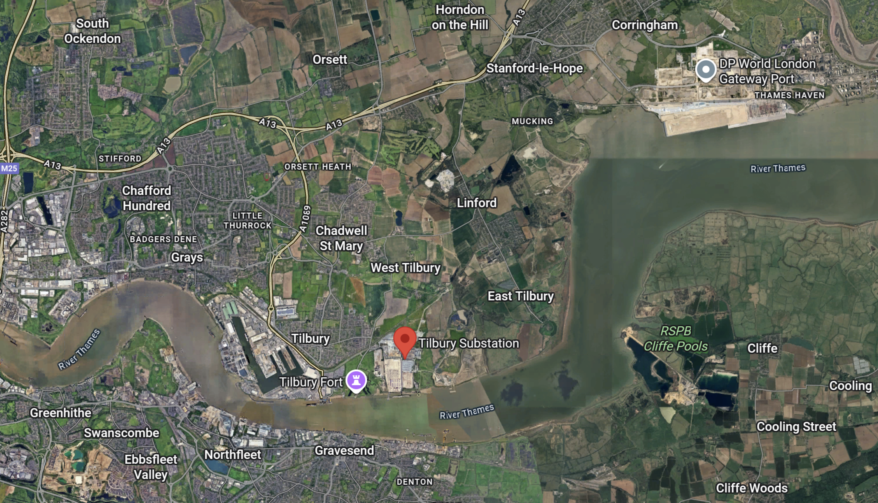
This Google Map shows London Gateway and the Port of Tilbury.
Note.
- DP World London Gateway is in the North-East corner of the map.
- The A13 road runs across the North-West corner of the map and links the area to London and the M25.
- Thurrock Storage is next to the Tilbury substation, which is marked by the red arrow.
- The Port of Tilbury is to the West of the substation.
I wonder if DP World London Gateway have had power supply problems.
The Design Of The First Artemis Project Management Software System
Before Artemis, project management was usually done on a large mainframe computer like an IBM-360-50, that I’d used extensively for solving simultaneous differential equations in a previous job at ICI.
Mainframe computers worked on complex problems, but to put it mildly, they were slow and needed a team to operate them and a big air-conditioned room to keep them happy.
When the four of us decided to create Artemis, our vision was something simpler.
- A processor – something like a PDP-11, which I judged would be big-enough for the computing.
- A visual display unit.
- A printer.
- A standard-size desk to hold the hardware.
- Ability to run from a 13-amp socket.
When it came to writing the software, I took few risks.
- Much of the data decoding software, I’d developed when I left ICI to write a program to solve up to a thousand simultaneous differential equations.
- The scheduling software was generic and I’d first used it for different purposes in two programs at ICI.
- The aggregation software had been devised, whilst I was a consultant at Lloyds Bank over several bottles of wine with their Chief Management Accountant, who was a wizard with numbers. I suspect, but can’t prove it, that if the idiots that programmed the Horizon system for the Post Office had used that algorithm, the problems there would have been much smaller.
- I also spent a lot of time reading old papers from the 1950s in IBM’s library on the South Bank, looking for better algorithms.
- I also made sure, I chose the best hardware and I believe HP did us proud.
- I used HP’s operating system and proprietary database to cut down, what could go wrong.
- Almost all of the first system was written by one person – me!
But we also put the right features into how we supported, delivered and trained users of the system.
I certainly, think we made few mistakes in the design of that first system.
Have Last Energy Used A Similar Cut Back Approach?
Reading their web site, I think they have.
They have obviously chosen, the 20 MW unit size with care.
But from worldwide experience with wind turbines, linking smaller power sources together, is not as difficult as it once was.
These are some of the statements on their web site’s introductory screens.
- Fully Modular, Factory Made
- A Scalable Solution
- <24 Month Delivery
- 100+ Supply Chain Partners
- 300+ Pressurised Water Reactors Operating Globally
- 0.3 acre – Plant Footprint Fits Within A Football Field
But a chain is only as strong as its weakest link.
It should be noted, that I have been over several nuclear power stations.
Three were a tour to show me how Artemis was being used to track and sign off, the problems identified after the Three Mile Island incident.
The other was a trip over Sizewell A, a couple of years before it was decommissioned.
Comparing these experiences with some of the chemical plants, that I’ve worked on, I would prefer to be close to a nuclear power plant.
Raft Of US-UK Nuclear Deals Ahead Of Trump Visit
The title of this post, is the same as that of this article on World Nuclear News.The article is a good summary of all the deals done between the US and UK governments concerning next-generation nuclear power.
This is the introduction.
Several agreements have been signed between UK and US companies to advance the deployment of small modular reactors and advanced reactors in both countries. The deals were signed ahead of the state visit of President Donald Trump to the UK later this week.
The whole article is a must-read.
These are my posts, that are related to the main agreement.
- Centrica And X-energy Agree To Deploy UK’s First Advanced Modular Reactors
- Nuclear Plan For Decommissioned Coal Power Station
- Rolls-Royce Welcomes Action From UK And US Governments To Usher In New ‘Golden Age’ Of Nuclear Energy
I shall finish it later.
Rolls-Royce Welcomes Action From UK And US Governments To Usher In New ‘Golden Age’ Of Nuclear Energy
The title of this post, is the same as that of this press release from Rolls-Royce.
These three paragraphs introduce the press release.
The agreement between the UK and US Governments to deepen cooperation in advanced nuclear technologies and make it quicker for companies to build new nuclear power stations sets the stage for a significant step forward in the energy security and resilience of the two nations. The Atlantic Partnership for Advanced Nuclear Energy will help ensure the accelerated development and deployment of advanced nuclear reactor technologies in the US and UK. Building a bridge between the world’s first and world’s largest civil nuclear power markets.
The global market for advanced nuclear technologies is estimated to be worth many trillions up to 2050. Secure, scalable and reliable power across civil, defence, industrial and maritime sectors is needed to meet growing demands in digital and AI. In the US alone, demand for nuclear power is forecast to grow from 100GWe to 400GWe by 2050.
Rolls-Royce stands ready to seize the opportunity to further innovate and partner in the development of advanced nuclear technologies which will deliver thousands of skilled jobs, attract investment and support the economic growth of both the US and the UK.
Note.
- Rolls-Royce have several partners for the SMR, who include Siemens and a couple of American companies.
- Rolls-Royce are involved with US company; BWXT, in one of the consortia developing a micro-reactor for the US Department of Defense, which I wrote about in Rolls-Royce To Play Key Role In US Department Of Defense Nuclear Microreactor Program.
- Rolls-Royce also has a large design, development and manufacturing presence in the United States.
- The new engines for the B-52s are from Rolls-Royce.
Rolls-Royce has a very strong footprint in the United States.
Gwynt Glas And South Wales Ports Combine Strength In Preparation For Multi-Billion Floating Wind Industry
The title of this post, is the same as that of this news item from the Gwynt Glas wind farm.
The news item starts with a spectacular image of a port, that is assembling floating wind turbines and these three paragraphs.
Gwynt Glas Offshore Wind Farm has signed a Memorandum of Understanding (MoU) with the UK’s largest port operator, Associated British Ports, and Wales’ largest energy port, the Port of Milford Haven, to ready the ports for the future needs of floating offshore wind in the Celtic Sea.
Gwynt Glas is a joint venture partnership between EDF Renewables UK and DP Energy. The proposed floating offshore wind farm would generate 1GW of low carbon green energy in the Celtic Sea.
Under the MoU, information and industry knowledge will be shared to investigate the potential opportunities for manufacture, assembly, load-out and servicing for the Gwynt Glas project from the key South Wales Ports of Port Talbot and Milford Haven. This collaborative approach demonstrates a major commitment to supporting economic growth, investment and maximising social value in the region.
UK Port Unveils GBP 150 Million Offshore Wind Expansion Plan
The title of this post, is the same as that of this article on offshoreWIND.biz.
This is the sub-heading.
The Port of Tyne, located in the northeast of England, has unveiled its plans to add 400 metres of deep-water quayside to support offshore renewables, clean energy, and advanced manufacturing.
These two paragraphs add details.
The Port of Tyne is investing GBP 150 million (approximately EUR 173 million) to transform 230 acres into the Tyne Clean Energy Park, a move that could create up to 12,000 jobs, deliver GBP 5.6 billion (about EUR 6.5 billion) to the economy, and establish the North East as a hub for the UK’s green energy revolution, according to an independent study by WSP.
The plan for Tyne Clean Energy Park includes a kilometre of both new and redeveloped deep-water, heavy-lift quay to facilitate the use of a 230-acre footprint located within an Industrial Strategy Zone.
The Wikipedia entry for the Port of Tyne has this opening paragraph.
The Port of Tyne comprises the commercial docks on and around the River Tyne in Tyne and Wear in the northeast of England.
This Google Map shows the River Tyne Through Newcastle.
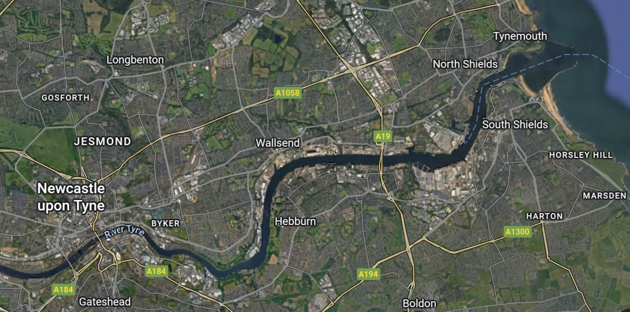
I estimate that this map is around twenty kilometres from East to West.
This news item from the Port of Tyne is entitled Port of Tyne Unviels 230 Acre Green Development Terminal and gives full details.
This summary is given.
The Port of Tyne is investing £150 million to transform 230 acres into the Tyne Clean Energy Park, adding 400 metres of deep-water quayside to support offshore renewables, clean energy, and advanced manufacturing. The redevelopment could create up to 12,000 jobs, deliver £5.6 billion to the economy, and establish the North East as a hub for the UK’s green energy revolution.
This is not a small development.
In future I shall tag developments like this with a tag of UK Port Development.
.
Nuclear Plan For Decommissioned Coal Power Station
The title of this post, is the same as that of this article on the BBC.
This is the sub-heading.
Nuclear power could be generated on the site of a former coal power station in Nottinghamshire.
These first four paragraphs add details.
Cottam Power Station was decommissioned in 2019, and in August its eight 114m (375ft) cooling towers were demolished.
Three businesses – American energy firm Holtec International, EDF UK, and real estate manager Tritax – have now signed an agreement to set up a small modular reactor (SMR) to power “advanced” data centres at the 900-acre site.
Holtec said the project could create “thousands of high-skilled manufacturing and construction jobs”, as well as “long-term roles”.
The SMR at Cottam would be the second of its kind, following the creation of a plant at Palisades in Michigan, in the US.
Note.
- Cottam was a 2,000 MW power station, that could run on coal, oil and biomass.
- If a nuclear power station is built at Cottam, it will be one of the first nuclear stations not close to the coast.
I asked Google AI for details of the plant at Palisades in Michigan and received this reply.
The Palisades SMR project at the Palisades Nuclear Plant in Michigan will feature two Holtec SMR-300 units, each producing at least 300 megawatts of power, for a combined total of at least 600-640 megawatts of net power. This project aims to have the first US dual-unit SMR 300 system operational by 2030, and the SMRs are designed to produce electricity and provide steam for other industrial purposes.
It does appear that the new generation of reactors from Holtec, Rolls-Royce and X-energy are smaller than many nuclear reactors built in the last twenty years.
This Google Map shows the Cottam site.
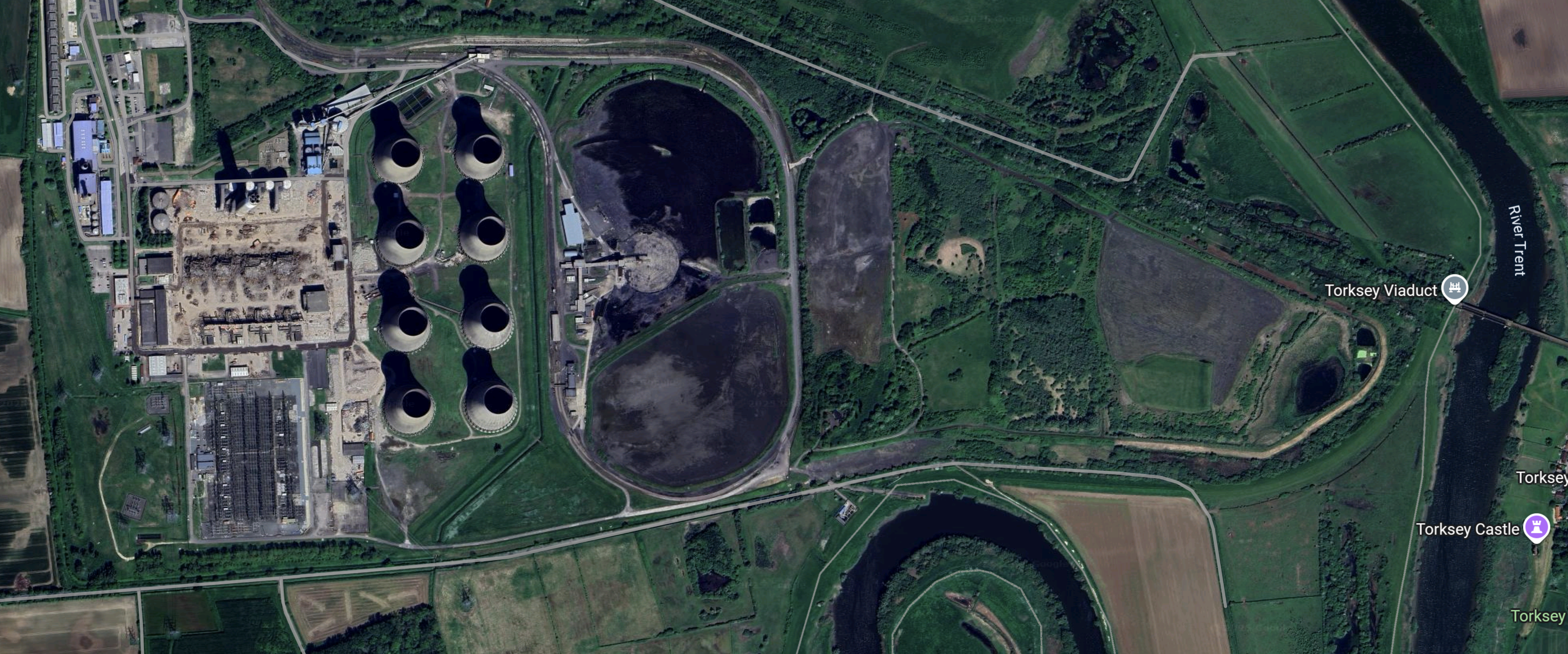
Note.
- The River Trent surrounds the site.
- Could the Trent be used for cooling water?
- The cooling towers are still in place, so the image must have been taken before August.
- The sub-station is in the South-West corner of the site.
- The railway over Torksey viaduct is disused.
It would appear that there is generous space for the SMRs and a few data centres.
The Cottam Solar Project
In DCO Decision On 480MW West Burton Solar NSIP Delayed Until 2025, I wrote about three large solar projects in Eastern England.
The Cottam Solar Project was one of the projects and wants to use the Cottam site.
- The Cottam Solar Project has a web site.
- It will have a capacity of 600 MW, with a battery, with a battery with a 600 MW output and a 600 MWh capacity.
- The solar farm will use the grid connection of the former coal-powered Cottam power station.
- The project is massive and will cover 1270 hectares.
Will this solar project lease space for the SMR, so they can co-exist?
Conclusion
It does appear that there are more than one use for old coal-fired power station sites.
Consultation Opens For Ferrybridge Next Generation Power Station
The title of this post, is the same as that of this press release from SSE.
These three bullet points act as sub-headings.
- Ferrybridge Next Generation sets out plans for continuing the legacy of power generation at the site, with the potential to bring significant investment to the region.
- Statutory consultation phase launched, inviting communities and stakeholders to have their say on project proposals.
- Hydrogen-enabled project could support the security of supply and offer a clear route to decarbonisation.
These three paragraphs add more detail.
Members of the public are being invited to have their say on plans for a proposed new power station in development, Ferrybridge Next Generation Power Station.
The station is being designed so that it can run on hydrogen, as a lower-carbon alternative to natural gas. It would also be able to operate using natural gas or a blend of hydrogen and natural gas until a technically and commercially viable hydrogen supply becomes available to the site.
With a proposed capacity of up to 1.2GW, Ferrybridge Next Generation Power Station could play an important role in supporting the UK’s energy system in the short term – providing reliable flexible back-up power during periods of peak demand and balancing the system when the wind doesn’t blow or the sun doesn’t shine, while delivering a route to decarbonised power generation in the longer term.
Note.
- A 150 MW/300 MWh Battery Electric Storage System is being developed on the site, which I wrote about in SSE Renewables Announces Construction Of Second Utility-Scale Battery Storage System.
- The last Ferrybridge power station; C had a capacity of just over 2 GW.
- This will be SSE Renewable’s second hydrogen-fired power station after Keadby, which I wrote about in Consultation On Plans For Keadby Hydrogen Power Station To Begin.
- As the press releases says, Ferrybridge Hydrogen-Fired Power Station will be West Yorkshire’s backup for when the wind doesn’t blow and the sun doesn’t shine.
How similar will the two hydrogen-fired power stations be?
Will SSE Be Building Any More In The First Wave Of Hydrogen-Fired Power Station?
This is a paragraph from SSE’s press release.
The station is being designed so that it can run on hydrogen, as a lower-carbon alternative to natural gas. It would also be able to operate using natural gas or a blend of hydrogen and natural gas until a technically and commercially viable hydrogen supply becomes available to the site.
It would appear that the availability of the hydrogen fuel may be a problem.
But places like Aberdeen, Bradford, Brighton, Humberside and Merseyside, do seem to be planning for hydrogen, so all is not lost.
Hydrogen Milestone: UK’s First Hydrogen-to-Power Trial At Brigg Energy Park
The title of this post, is the same as that of this press release from Centrica.
This is the sub-heading.
Centrica and HiiROC, supported by the Net Zero Technology Centre (NZTC), have successfully demonstrated the injection of hydrogen into a gas-fired peak power plant at Centrica’s Brigg Energy Park, North Lincolnshire. The trial that took place last Thursday (11 September) marks a UK first in using hydrogen to decarbonise peak power generation supplying power directly to the electricity grid.
These three opening paragraphs add detail.
HiiROC’s modular hydrogen production technology, using Thermal Plasma Electrolysis (TPE), produced hydrogen on site which was then blended at a 3% ratio for the purposes of a one-hour trial.
The trial marks a further step forward in Centrica’s ongoing efforts to advance innovative solutions for the decarbonisation of its portfolio of gas plants, demonstrating that existing gas infrastructure can operate on a hydrogen blend to provide reliable, low carbon electricity to UK homes and businesses. More broadly, the trial shows a viable route for delivering on decarbonisation readiness obligations for peaker generation as part of the UK’s journey to net zero.
It is also a key milestone in HiiROC’s journey, demonstrating the effectiveness and affordability of HiiROC’s TPE process, which produces hydrogen without CO2 emissions, making it compliant with the UK’s Low Carbon Hydrogen Standard (LCHS). By leveraging the existing gas network and co-locating hydrogen production where it is needed, operators can decarbonise without costly new infrastructure.
Note.
- This test was only at a low level of hydrogen.
- Brigg power station is a 240 MW power station, which is fuelled by natural gas.
A long journey starts with a single step.
Centrica And X-energy Agree To Deploy UK’s First Advanced Modular Reactors
The title of this post, is the same as that of this press release from Centrica.
This is the sub-heading.
Centrica and X-Energy, LLC, a wholly-owned subsidiary of X-Energy Reactor Company, LLC, today announced their entry into a Joint Development Agreement (JDA) to deploy X-energy’s Xe-100 Advanced Modular Reactors (“AMR”) in the United Kingdom.
These three paragraphs add more details.
The companies have identified EDF and Centrica’s Hartlepool site as the preferred first site for a planned U.K. fleet of up to 6 gigawatts.
The agreement represents the first stage in a new trans-Atlantic alliance which could ultimately mobilise at least £40 billion in economic value to bring clean, safe and affordable power to thousands of homes and industries across the country and substantive work for the domestic and global supply chain.
A 12-unit Xe-100 deployment at Hartlepool could add up to 960 megawatts (“MW”) of new capacity, enough clean power for 1.5 million homes and over £12 billion in lifetime economic value. It would be developed at a site adjacent to Hartlepool’s existing nuclear power station which is currently scheduled to cease generating electricity in 2028. Following its decommissioning, new reactors would accelerate opportunities for the site and its skilled workforce. The site is already designated for new nuclear under the Government’s National Policy Statement and a new plant would also play a critical role in generating high-temperature heat that could support Teesside’s heavy industries.
This is no toe-in-the-water project, but a bold deployment of a fleet of small modular reactors to provide the power for the North-East of England for the foreseeable future.
These are my thoughts.
The Reactor Design
The Wikipedia entry for X-energy has a section called Reactor Design, where this is said.
The Xe-100 is a proposed pebble bed high-temperature gas-cooled nuclear reactor design that is planned to be smaller, simpler and safer when compared to conventional nuclear designs. Pebble bed high temperature gas-cooled reactors were first proposed in 1944. Each reactor is planned to generate 200 MWt and approximately 76 MWe. The fuel for the Xe-100 is a spherical fuel element, or pebble, that utilizes the tristructural isotropic (TRISO) particle nuclear fuel design, with high-assay LEU (HALEU) uranium fuel enriched to 20%, to allow for longer periods between refueling. X-energy claims that TRISO fuel will make nuclear meltdowns virtually impossible.
Note.
- It is not a conventional design.
- Each reactor is only about 76 MW.
- This fits with “12-unit Xe-100 deployment at Hartlepool could add up to 960 megawatts (“MW”) of new capacity” in the Centrica press release.
- The 960 MW proposed for Hartlepool is roughly twice the size of the Rolls-Rpoyce SMR, which is 470 MW .
- Safety seems to be at the forefront of the design.
- I would assume, that the modular nature of the design, makes expansion easier.
I have no reason to believe that it is not a well-designed reactor.
Will Hartlepool Be The First Site?
No!
This page on the X-energy web site, describes their site in Texas, which appears will be a 320 MW power station providing power for Dow’s large site.
There appear to be similarities between the Texas and Hartlepool sites.
- Both are supporting industry clustered close to the power station.
- Both power stations appear to be supplying heat as well as electricity, which is common practice on large industrial sites.
- Both use a fleet of small modular reactors.
But Hartlepool will use twelve reactors, as opposed to the four in Texas.
How Will The New Power Station Compare With The Current Hartlepool Nuclear Power Station?
Consider.
- The current Hartlepool nuclear power station has two units with a total capacity of 1,185 MW.
- The proposed Hartlepool nuclear power station will have twelve units with a total capacity of 960 MW.
- My instinct as a Control Engineer gives me the feeling, that more units means higher reliability.
- I suspect that offshore wind will make up the difference between the power output of the current and proposed power stations.
As the current Hartlepool nuclear power station is effectively being replaced with a slightly smaller station new station, if they get the project management right, it could be a painless exercise.
Will This Be The First Of Several Projects?
The press release has this paragraph.
Centrica will provide initial project capital for development with the goal of initiating full-scale activities in 2026. Subject to regulatory approval, the first electricity generation would be expected in the mid-2030s. Centrica and X-energy are already in discussions with additional potential equity partners, as well as leading global engineering and construction companies, with the goal of establishing a UK-based development company to develop this first and subsequent projects.
This approach is very similar to the approach being taken by Rolls-Royce for their small modular reactors.
Will Centrica Use An X-energy Fleet Of Advanced Modular Reactors At The Grain LNG Terminal?
This press release from Centrica is entitled Investment In Grain LNG Terminal.
This is one of the key highlights of the press release.
Opportunities for efficiencies to create additional near-term value, and future development options including a combined heat and power plant, bunkering, hydrogen and ammonia.
Note.
- Bunkering would be provided for ships powered by LNG, hydrogen or ammonia.
- Heat would be needed from the combined heat and power plant to gasify the LNG.
- Power would be needed from the combined heat and power plant to generate the hydrogen and ammonia and compress and/or liquify gases.
Currently, the heat and power is provided by the 1,275 MW Grain CHP gas-fired power station, but a new nuclear power station would help to decarbonise the terminal.
Replacement Of Heysham 1 Nuclear Power Station
Heysham 1 nuclear power station is part-owned by Centrica and EdF, as is Hartlepool nuclear power station.
Heysham 1 nuclear power station is a 3,000 MW nuclear power station, which is due to be decommissioned in 2028.
I don’t see why this power station can’t be replaced in the same manner as Hartlepool nuclear power station.
Replacement Of Heysham 2 Nuclear Power Station
Heysham 2 nuclear power station is part-owned by Centrica and EdF, as is Hartlepool nuclear power station.
Heysham 2 nuclear power station is a 3,100 MW nuclear power station, which is due to be decommissioned in 2030.
I don’t see why this power station can’t be replaced in the same manner as Hartlepool nuclear power station.
Replacement Of Torness Nuclear Power Station
Torness nuclear power station is part-owned by Centrica and EdF, as is Hartlepool nuclear power station.
Torness nuclear power station is a 1,290 MW nuclear power station, which is due to be decommissioned in 2030.
I don’t see why this power station can’t be replaced in the same manner as Hartlepool nuclear power station.
But the Scottish Nationalist Party may have other ideas?
What Would Be The Size Of Centrica’s And X-energy’s Fleet Of Advanced Modular Reactors?
Suppose.
- Hartlepool, Grain CHP and Torness power stations were to be replaced by identical 960 MW ADRs.
- Heysham 1 and Heysham 2 power stations were to be replaced by identical 1,500 MW ADRs.
This would give a total fleet size of 5,880 MW.
A paragraph in Centrica’s press release says this.
The companies have identified EDF and Centrica’s Hartlepool site as the preferred first site for a planned U.K. fleet of up to 6 gigawatts.
This fleet is only 120 MW short.
