Demonstration Of Commercial-Size Hydrogen Module
The title of this post, is the same as that of news item on the SunHydrogen web site.
This is the sub-heading.
SunHydrogen has successfully demonstrated live operation of its commercial-size 1.92m² hydrogen module, producing renewable hydrogen using only sunlight and water. This major milestone showcases the scalability and off-grid potential of the company’s renewable hydrogen production technology.
These first three paragraphs add more details.
SunHydrogen, developer of a breakthrough technology to produce renewable hydrogen using sunlight and water, today announced the successful live operation of its 1.92 m² (20.7 sq. ft.) hydrogen module. Conducted in an open prototype housing, the demonstration marks a pivotal milestone in the company’s path toward commercial-scale, renewable hydrogen production.
The 1.92m² hydrogen module, which uses only sunlight and water to produce hydrogen, represents the most advanced version of SunHydrogen’s proprietary hydrogen production technology. Engineered to operate independent of the electrical grid, the system integrates solar collection and hydrogen production into a single unit, offering a modular and scalable solution for distributed renewable hydrogen.
“This successful demonstration of the commercial-size reactor underscores the progress we’ve made in bringing our technology out of the lab and into the real world,” said Tim Young, CEO of SunHydrogen.
There is a video of this demonstration.
On their home page, there is a section called A Breakthrough In Clean Energy, where this is said.
SunHydrogen has developed a breakthrough technology to produce renewable hydrogen using sunlight and any source of water.
By optimizing the science of water electrolysis at the nano-level, our low-cost photoelectrochemical technology uses sunlight to separate hydrogen from water, making the process truly green from start to finish.
I will accept their word that it is truly green, but it is truly unique in that it doesn’t appear to use only sunlight to generate hydrogen.
It Was Hot So I Drunk A Lot Today
It’s still 35 degrees as I write this and judging by the empties I’ve been drinking heavily all day.

I’ve actually had six bottles of Adnams 0.5% Alcohol Ghost Ship, as I started at 09:00 this morning and I’ve also drunk two cans of Diet Coke and three mugs of tea. So I must have drunk close to four litres today, none of which was alcoholic.
But when I was eighteen and serving in The Merryhills pub in Oakwood, I can remember drinking thirteen bottles of Guinness and walking home.
At the time, I didn’t know I was coeliac, so why did the beer not effect my gut?
As my father, who was undoubtedly an undiagnosed coeliac, also drank bottles of Guinness, were the bottles gluten-free, as I believe Guinness 0.0 is today.
It certainly looks like my grandfather, who was a professional alcoholic could have got started on beer to just keep himself hydrated. He then moved on to spirits and that contributed to his early death around forty.
US Floating Wind Platform Developer Issues RFI To Fabricators Worldwide
The title of this post, is the same as that of this article on offshoreWIND.biz.
This is the sub-heading.
Aikido Technologies, which recently secured a spot at a Norwegian offshore demo site, has released an RFI for its 15 MW ‘AO60’ floating wind platform to offshore wind fabricators.
These are the first four paragraphs which add more details.
The California-based floating wind foundation developer said on social media that it had issued the RFI to more than ten “top-tier offshore wind fabricators from around the world”.
The RFI has been released in three separate packages, each tailored to a specific type of facility: one for standard offshore steel shops, one for tubular/jacket yards, and one for monopile/tower facilities.
“This is how we can build 1, 50 or 100 of these units with existing fabrication capabilities, with components that can be easily transported around the world for final assembly at a local port. No need for custom yards, custom vessels or custom ports”, Aikido Technologies said.
In May 2025, the company was allocated a slot for its AO60 platform at the Marine Energy Test Centre (METCentre) in Norway, where Aikido will deploy what it says is a first-of-its-kind 15 MW demonstration project.
As someone, who wrote project management computer systems for thirty years, I like Aikido’s plans and feel they would be well suited to the UK, where we have quite a few local ports, that would appear suitable for final assembly of the A060 platforms.
In Yarmouth Harbour To Be ‘Completed’ In £60m Project, I describe the expansion of the Port of Great Yarmouth.
These two paragraphs describe the work to be done.
Peel Ports said it would invest between £50m and £60m in Great Yarmouth’s Outer Harbour by developing the southern terminal, creating a roll-on roll-off (RORO) lift ramp and a large storage area.
Port director Richard Goffin said the construction work, which is set to begin in 2026, would “complete” the port as laid out in a business case in the early 2000s.
This image from Peel Ports Group shows how the Port of Great Yarmouth will look after the the proposed development.
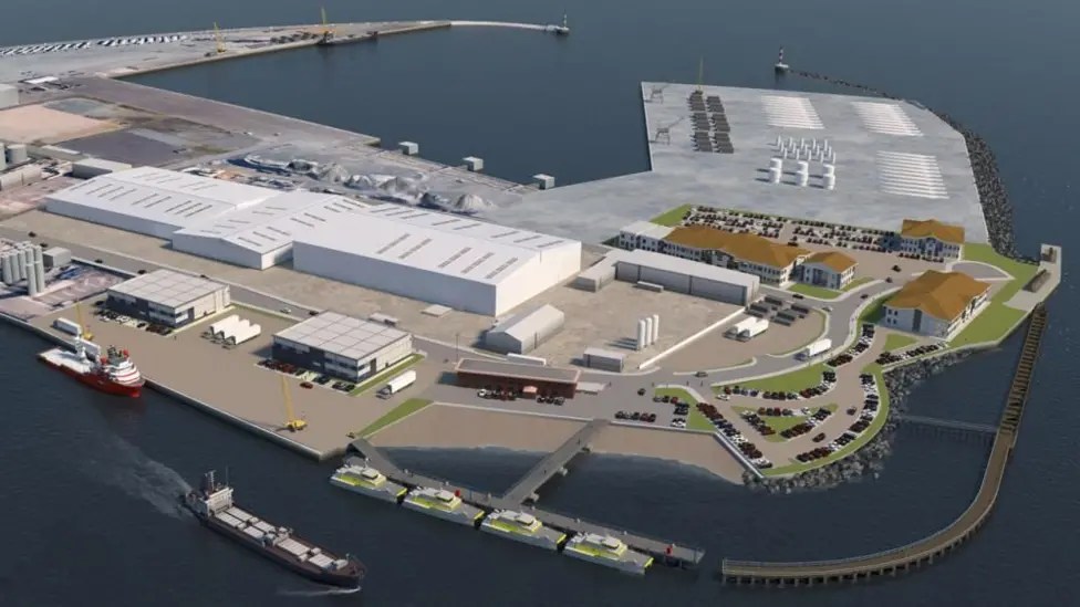
As the Port of Great Yarmouth has a depth of ten metres it could be an ideal base for the assembly and maintenance of floating wind turbines.
Renewable Power By 2030 In The UK
I am doing this to see what the total output will be by the net election.
Offshore Wind Power
I shall start with offshore wind power.
- Operational in July 2025 – 16,035 MW
- 2025 – Dogger Bank A – 1,235 MW
- 2026 – Sofia – 1,400 MW
- 2026 – Dogger Bank B – 1,235 MW
- 2026 – East Anglia 1 North – 800 MW
- 2026 – East Anglia 3 – 1,372 MW
- 2027 – Dogger Bank C – 1,218 MW
- 2027 – Hornsea 3 – 2,852 MW
- 2027 – Inch Cape – 1,080 MW
- 2027 – Llŷr 1 – 100 MW
- 2027 – Llŷr 2 – 100 MW
- 2027 – Norfolk Boreas – 1,380 M
- 2027 – Whitecross – 100 MW
- 2028 – Aspen – 1008 MW
- 2028 – Morecambe – 480 MW
- 2028 – Ossian – 2,610 MW
- 2028 – Stromar – 900 MW
- 2029 – Beech – 1008 MW
- 2029 – East Anglia 2 – 967 MW
- 2029 – Green Volt – 400 MW
- 2029 – Mona – 1,500 MW
- 2029 – Morgan – 1,500 MW
- 2029 – Norfolk Vanguard East – 1,380 MW
- 2029 – Norfolk Vanguard West – 1,380 MW
- 2029 – North Falls – 504 MW
- 2029 – West of Orkney – 2,000 MW
- 2030 – Awel y Môr – 500 MW
- 2030 – Bellrock – 1,200 MW
- 2030 – Berwick Bank – 4,100 MW
- 2030 – Caledonia – 2,000 MW
- 2030 – Cedar – 1008 MW
- 2030 – Five Estuaries – 353 MW
- 2030 – Morven – 2,907 MW
- 2030 – N3 Project – 495 MW
- 2030 – Outer Dowsing – 1,500 MW
- 2030 – Rampion 2 Extension – 1,200 MW
This gives these yearly totals, if I use pessimistic dates.
- 2025 – 1,235 MW
- 2026 – 4,807 MW
- 2027 – 5,350 MW
- 2028 – 4,998 MW
- 2029 – 9,631 MW
- 2030 – 15,263 MW
This adds up to a total of 58,897 MW.
Solar Power
For solar power, I just asked Google AI and received this answer.
The UK government aims to have between 45 and 47 gigawatts (GW) of solar power capacity by 2030. This goal is set out in the Solar Roadmap and aims to reduce energy bills and support the UK’s clean power objectives. The roadmap includes measures like installing solar on new homes and buildings, exploring solar carports, and improving access to rooftop solar for renters.
Let’s assume that we only achieve the lowest value of 45 GW.
But that will still give us at least 100 GW of renewable zero-carbon power.
Energy Storage
For pumped storage hydro, I asked Google AI and received this answer.
The UK’s pumped storage hydro (PSH) capacity is projected to more than double by 2030, with six projects in Scotland, including Coire Glas and Cruachan 2, potentially increasing capacity to around 7.7 GW from the current approximately 3 GW. This would be a significant step towards meeting the National Grid’s required 13 GW of new energy storage by 2030, though achieving this depends on policy support and investment.
It looks like there is about another 5 GW of capacity to find.
Hull Trains Allows Delay Compensation To Be Donated To Charity
The title of this post is the same as that of this article on Rail Advent.
These four paragraphs fill in the details.
Customers of Hull Trains who claim compensation for train delays can now choose to donate their Delay Repay funds to charity.
Hull Trains’ new official charity partner for 2025 is P.A.U.L For Brain Recovery, which supports people across the Humber region affected by acquired brain injury. P.A.U.L For Brain Recovery is based in Hull, and has recently expanded its support to cover communities in north and northeast Lincolnshire, and has ambitions to support people further afield.
The new scheme will allow customers to opt for the delay compensation to be sent directly to the charity. Hull Trains operates trains between Hull and London King’s Cross, stopping at Grantham in Lincolnshire, and serving other stations on the East Coast route, including Doncaster and Beverley.
The founder and CEO of P.A.U.L For Brain Recovery is Paul Spence. In 2012, Paul suffered a brain haemorrhage when he was the victim of an unprovoked attack. After he was discharged from a high dependency unit, he and his family faced a long and challenging road to recovery, and quickly realised that support available in the community was sadly lacking.
I think it’s rather a good idea.
Trump Wants National Guard To Dump Homeless ‘Far From Washington’
The title of this post is the same as that of this article on The Times.
On reading that title, I asked Google, what Adolf Hitler did with the homeless.
Wikipedia gave this answer.
In 1933, the Nazi Party passed a Law “against Habitual and Dangerous Criminals”, which allowed for the relocation of beggars, homeless, and the unemployed to concentration camps.
I know Trump has German ancestry, but!
Hydrogen Deployment Milestone For Cemex And HiiROC
The title of this post, is the same as that of this article on Agg-Net.
This is the sub-heading.
Cemex kick-start first-of-a-kind low-carbon hydrogen project using thermal plasma electrolysis in cement production
These first two paragraphs add more detail.
CEMEX Ventures, Cemex’s corporate venture capital (CVC) and open innovation unit, announced today an initial hydrogen deployment at industrial scale with HiiROC, the pioneering British hydrogen company that produces affordable, clean hydrogen, at their Rugby cement plant in the UK.
Hydrogen has emerged as a low-carbon energy source within the construction industry’s decarbonization roadmap and offers potential as an energy solution to help reduce the sector’s reliance on fossil fuels and lower CO2 emissions. This venture marks a significant milestone for Cemex, as it represents the beginning of a large-scale strategic project plan with the aim to further lower their carbon emissions in cement production.
These third paragraph is a good outline of HiiROC and how it can be deployed.
HiiROC produce carbon-neutral hydrogen using their proprietary Thermal Plasma Electrolysis (TPE) process, which requires just one-fifth of the electrical energy used in water electrolysis and captures carbon as a solid by-product, avoiding CO2 emissions – a game-changer for the industry. HiiROC’s modular solution can be deployed as single units to full-scale industrial plants, and the hydrogen produced can be used as an alternative energy source to fuel clinker production processes, helping Cemex to achieve their decarbonization goals.
Centrica, Cemex, Hyundai, Kia and others are investors in HiiROC.
I asked Google AI, what percentage of carbon emissions came from cement production and got this answer.
Cement production accounts for roughly 8% of global carbon dioxide (CO2) emissions, according to think tank Chatham House. This makes it a significant contributor to climate change, with the industry’s emissions comparable to the total emissions of some countries.
If HiiROC can take a big bite out of carbon emissions, by reducing cement production’s 8 % share, they would be on a winner.
Did I Have A Funny Turn Caused By Dehydration This Morning?
I followed my usual Sunday morning routine today
- I took my drugs with a large mug of tea.
- I had a deep bath with emollient in the water.
- I put my head under the water and opened my eyes, to clear the massive amount of sleep, I get overnight in my eyes.
- I then went to Leon in Hanover Square for a good Full English gluten-free breakfast.
Unusually, Leon made a mistake and didn’t put any milk in my tea, so I didn’t drink it. So was I low on fluids?
A Transformer Is Being Moved Tonight
This press release from National Grid is entitled National Grid Prepares For Two Major Supergrid Transformer Deliveries In London.
The first one is to be moved into Redbridge substation tonight, so I went to have a look after breakfast.
- It was easy to get to the site, as it is close to Redbridge station on the Central Line.
- Out of the Underground, it was quite hot.
- By the time, I got to Redbridge station, I was feeling slightly unwell and felt my balance was poor.
- So I immediately turned around and came home using the Central and Lizzie Lines to Moorgate, where I took a bus home.
- I was certainly feeling better in the air-conditioned atmosphere of the Lizzie Line.
Since I’ve been home, I have been continuously drinking Adnams 0.5 % Alcohol Ghost Ship and I feel that I am now back to normal.
I asked Google AI “Can being dehydrated affect your balance?” and got this answer.
Yes, dehydration can definitely affect balance. It can lead to dizziness and a feeling of unsteadiness, which can make it harder to maintain balance. This is because dehydration can disrupt the fluid balance in the inner ear, which plays a vital role in balance.
I can remember an incident in my thirties, when I fell down the escalator at Oxford Circus station and went round to the Middlesex Hospital to be cleaned up.
Did Dehydration Play A Part In My Serious Stroke?
I had my stroke during breakfast in the Mandarin Oriental Hotel in Hong Kong. I’d had two or possibly three very small strokes early in the morning before and I know from measuring my weight, that I can lose up to a kilo overnight.
So I asked Google AI “Can dehydration cause strokes?” and got this answer.
Yes, dehydration can increase the risk of stroke. When the body lacks sufficient fluids, blood volume decreases, potentially leading to thicker blood and reduced blood flow to the brain. This can exacerbate existing blockages in blood vessels or make it more difficult for blood to reach the brain, potentially causing an ischemic stroke.
My late wife drunk a lot more fluids that I do and perhaps, I should have followed her example more, of always having water handy?
Man Finds Prehistoric Handaxe On His Tea Break
The title of this post, is the same as that of this article on the BBC.
This is the sub-heading.
A man discovered a prehistoric handaxe while he was “kicking his feet” on the ground during a tea break.
These are the first three paragraphs, which add some detail to the story.
Colin Cooley, 57, from Otley, Suffolk, works as a dumper driver on the Sizewell C excavation site.
Toward the end of a tea break, he noticed a piece of rock that he believed looked like a handaxe.
“All hell broke loose” when it was confirmed to be between 36,000 and 59,000 years old, and Hadley Sharman, an archaeologist working on the site, added it was a “blinder” of a find.
I suppose that the Nimbies will use the find to stop the power station getting built!
On the other hand Crossrail has used archaeology to make friends with the public, as I pointed out in Bison To Bedlam Or How To Make Friends.
