Beeching Reversal – Cirencester Community Railway
This is one of the Beeching Reversal projects that the Government and Network Rail are proposing to reverse some of the Beeching cuts.
It is also one of only a few of these projects, that has a very detailed plan.
- The plan has been written to the sort of standards, that would be expected of competent professionals from one of the large international rail consultancies.
- The plan is explained in detail on a comprehensive web site.
- The authors seem to have knowledge of recent developments in rail technology.
After a visit to Cirencester in November 2019, I wrote Could Cirencester Be Reconnected To The Rail Network?, which I started with this paragraph.
In Boris Johnson Vows New Life For High Streets And Axed Rail Lines, I laid out a list of rail lines that could be reopened by a future Conservative government.
Today, I’m going to Cirencester to have lunch with an old friend.
But, Cirencester does not have a rail connection, although there used to be a Cirencester branch line from Kemble station.
This was my conclusion.
With some clever and sympathetic engineering on the branch to handle the crossings, it could be a feasible reopening.
I also felt that a tram-train with batteries, could serve a two trains per hour (tph) service between Swindon and Cirencester via Kemble.
These are some details from the Cirencester Community Railway (CCR) plan.
The Route
In my post, I thought the last part of the route into Cirencester could be a problem.
The authors of the scheme have come up with an elegant solution.
- Between Kemble station and Parklease Farm, the route follows the previous route.
- Between Parklease Farm and the A433 Tetbury Road, the route runs North-South, possible along the route of an existing track.
- The route then follows the A433 into the town.
It is simple and there won’t be much major construction.
- A new bridge over the A429 will be needed.
- The track will need to cross the A433 on the level. It appears that this could be fitted in with major works to provide access to a new housing development.
All of the construction needed is laid out in the CCR report.
Single Or Double Track?
The report says that it will be built single track, which should be sufficient. Although there may be a need for a passing place around halfway to allow a more frequent service.
The Stations
Before detailing the stations, I will show this Google Map, which shows the route of the A433 Tetbury Road into Cirencester.
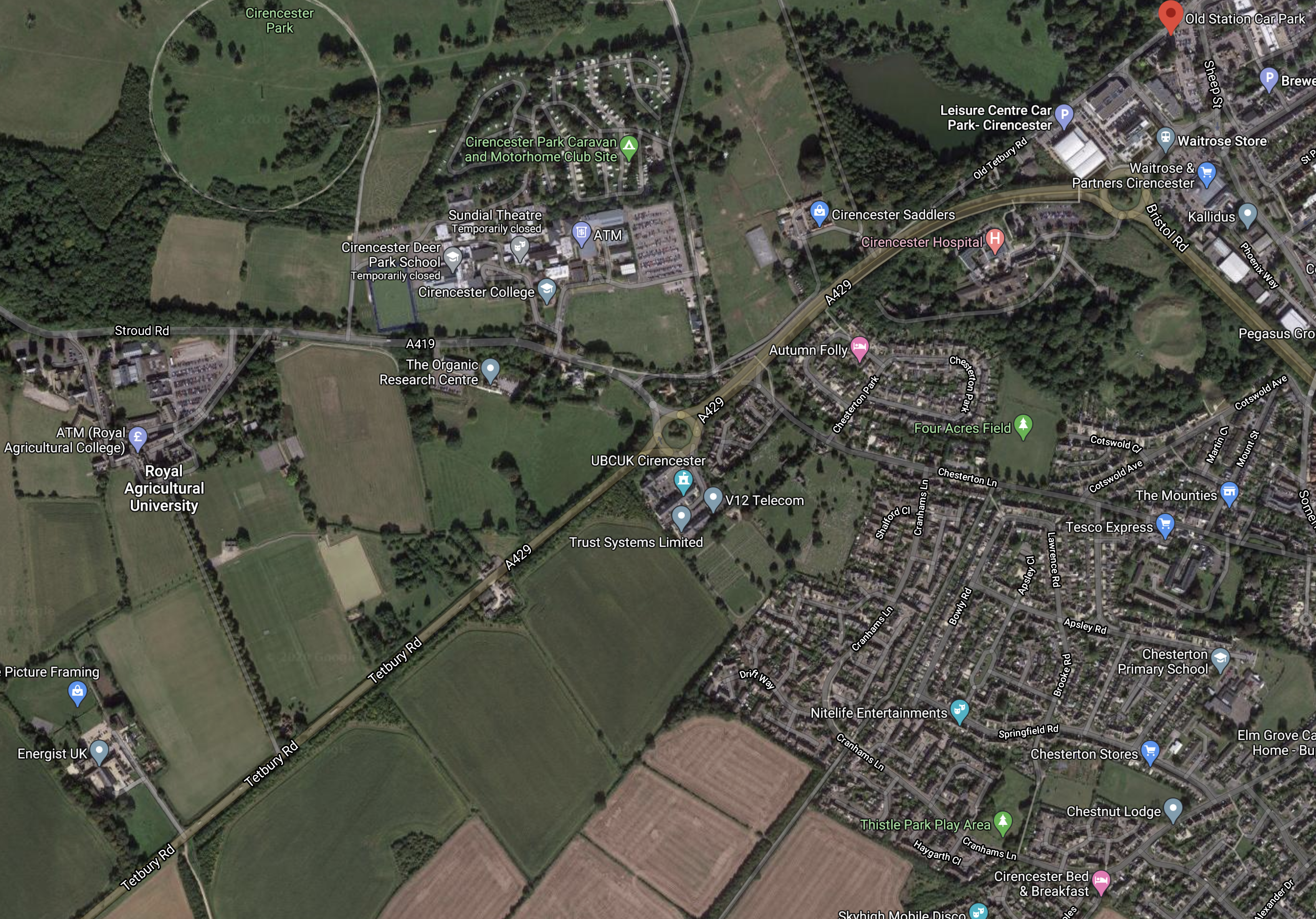
Note.
- The A 433 running SW-NE across the map.
- The Royal Agricultural University towards the West of the map.
- Cirencester College to the North-East of the University.
- The red arrow in the North-East corner of the map, which marks the Old Station Car Park.
The design envisages the following stations.
Parklease Farm
This station could be added, where the track changes direction, when it leaves the old route. It lies to the South of the Royal Agricultural University and off the map above.
It would probably be by request.
The University Station
This would be the main station on the route.
- It would serve the Royal Agricultural University.
- It would act as a Park-and-Ride station, with a large car park.
- Overnight stabling for the trains could be provided here.
If a passing loop is needed it could be added at this station.
The College Halt
This would be to the East of the roundabout on the map and would serve Cirencester College.
The Town Halt
This would be on the edge of the town centre, by the Old Station Car Park.
The Vehicles
The plan envisages using Very Light Rail vehicles.
- If these run on concrete tracks, as the report indicates, then effectively this means the the CCR will be separate from the UK rail network and through running will not be possible.
- In my post, I proposed battery tram-trains as these would allow extra local services between Kemble and Swindon, which might be needed if there was substantial housing development in the area.
- But then I like tram-trains and felt they would be a way to get to the centre of Cirencester. But the CCR’s route avoids the need for tram-trains.
I also wonder, if Very Light Rail would offer enough capacity. But it could probably offer a higher frequency easier than heavy rail.
Service Frequency
Nothing is said in the CCR report about service frequency.
As the University station doubles as a Park-and-Ride for the town, I think the frequency between the University station and the Town halt should be at least four tph.
Would this frequency apply to the whole of the CCR?
Great Western Railway’s Attitude
I can’t speak for Great Western Railway (GWR), but surely they would hope that the CCR would bring them a large number of passengers..
Currently, there is a two tph service between Swindon and Cheltenham through Kemble! Will this provide a good connection with the Cirencester service? Or will passengers find that they waste thirty minutes waiting for trains.
This was one of the reasons, I proposed tram-trains in my original post.
But this would not be a problem unique to the CCR, as the GWR has several branch lines with a similar problem.
So will GWR develop a company-wide solution to feed passengers in from branch lines?
Conclusion
The CCR have produced a well-thought out and detailed plan, but I think it can be improved. Especially, if GWR develop a company-wide solution for branch lines.
Beeching Reversal – Reopening Stratford-upon-Avon And Honeybourne-Worcester/Oxford (SWO) Railway Line
This is one of the Beeching Reversal projects that the Government and Network Rail are proposing to reverse some of the Beeching cuts.
I covered this route in RSC Urges GWR To Provide Stratford Improvements and came to these conclusions.
There are three ways to improve rail access to Stratford-upon-Avon.
-
- The relatively easy and quick, enhancement of the rail services in Warwickshire.
- Provide better one-change routes using Chiltern Railways.
- The more difficult re-connection of Stratford to the Cotswold Line at Honeybourne.
As the last project will take years to implement, I feel, it is important that services to Stratford from Birmingham, Coventry, Leamington Spa and the West Midlands are substantially increased.
I also believe that the responsibility of providing a local service between Leamigton Spa and Stratford should be given to West Midlands Trains.
The Case To Reconnect Stratford-on-Avon and Honeybourne Stations
In Where Is London Midland Going?, I wrote this section in July 2017.
The North Warwickshire Line
The North Warwickshire Line links Birmingham with Stratford-on-Avon and has an alternative name of the Shakespeare Line.
Plans exist to extend this line South to Honeybourne station on the Cotswold Line.
Under Possible Future Development in the Wikipedia entry for the Warwickshire Line, this is said.
The Shakespeare Line Promotion Group is promoting a scheme to reopen the 9 miles (14 km) of line south of Stratford to Honeybourne where it would link to the Cotswold Line. Called the “Avon Rail Link”, the scheme (supported as a freight diversionary route by DB Schenker) would make Stratford-upon-Avon station a through station once again with improved connections to the South, and would open up the possibility of direct services to Oxford and Worcester via Evesham. The scheme faces local opposition. However, there is a good business case for Stratford-Cotswolds link.
I think we’ll see something in the new franchise about developing this line, as there is a lot of potential for a train operator.
-
- Direct services between Stratford-on-Avon and Oxford, where there is a connection to Bicester Village. Tourists would love that!
- Connection of the housing development at Long Marston to Birmingham.
- Could Stratford-on-Avon or Honeybourne become the terminus of a service from Leamington, Coventry and Nuneaton?
It would also give DB Schenker, their freight diversion.
But we didn’t see anything in the new franchise and the project has turned up in the list of Beeching Reversal projects.
The Route Into Stratford-Upon-Avon
This Google Map shows Stratford-upon-Avon station.
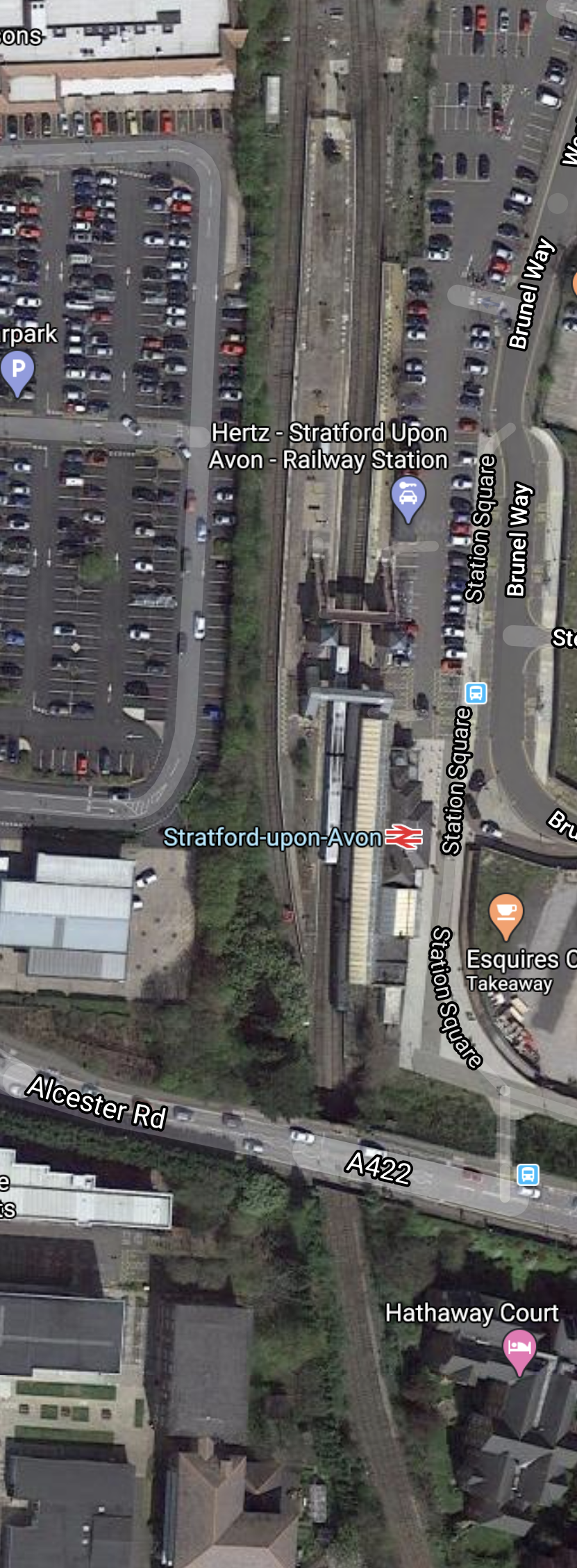
Note.
- The station is well-appointed with step-free access and three platforms.
- The bridge at the Southern end of the station to allow the railway to go South, appears to be intact.
This second Google Map shows the area of the town from the station to the racecourse.
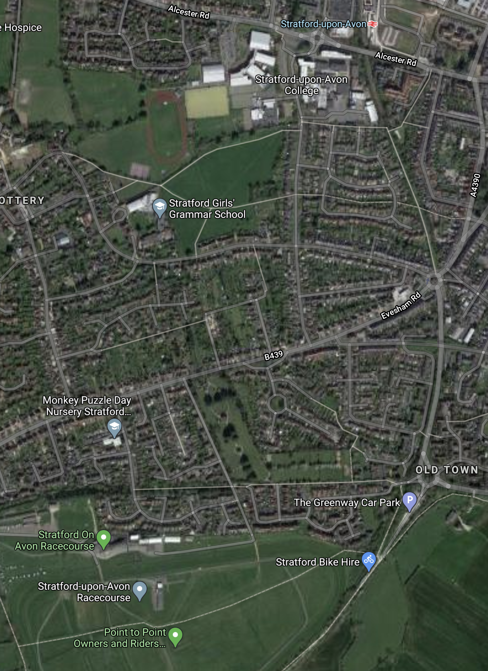
Note.
- Stratford-upon-Avon station at the top of the map.
- Stratford Racecourse at the bottom of the map.
The road curving between the station and the racecourse is the track of the former Stratford to Honeybourne railway.
My first reaction, when I saw this was that those, who want to rebuild this railway can’t be serious.
- Would you want one of DB Schenker’s noisy, smelly and polluting Class 66 locomotives running past your house?
- Would you want the line to be electrified, so they could use electric locomotives on this short stretch of railway? If so would DB Schenker be happy to change locomotives twice?
I have looked at new railways entering towns and cities all over the UK and Europe and feel there is only two possible solutions for Southern access to Stratford-upon-Avon station.
- A single-track passenger-only railway run by battery electric trains.
- A tunnel, which would probably be single-bore for cost reasons.
South of Stratford, the route is easier and it can be picked out on Google Maps until it reaches the Cotswold Line to the East of Honeybourne station.
This Google Map shows Honeybourne station and the junction.
Note.
- The Cotswold Line running NW-SE across the map.
- The large triangular junction that connected the line to Stratford-upon-Avon station, which is to the North-East.
- Another track going South from the junction, can be picked out. This leads to the heritage Gloucestershire Warwickshire Railway at Broadway station, with onward connections to Cheltenham Racecourse.
Honeybourne station could be an important rail hub.
Honeybourne Station And Battery Electric Trains
Consider.
- Hereford and Honeybourne stations are 48 miles apart.
- Didcot East Junction, where trains switch to and from the Great Western Main Line electrification and Honeybourne stations are 48 miles apart.
- Trains to Hereford pass through Great Malvern, Worcestershire Parkway and Worcester Foregate Street.
- Stratford-up-on-Avon and Honeybourne stations would be less than thirty miles apart, if the two stations were to be reconnected by rail.
- Hitachi’s proposed battery electric trains will have a range of 56 miles on battery power.
If the means to charge battery electric trains were provided in the Honeybourne area, the following services could be run by battery electric trains.
- London Paddington and Worcestershire Parkway, Worcester Foregate Street, Great Malvern and Hereford.
- Honeybourne and Stratford-upon-Avon
The charging could be performed, by a ten minute stop at Honeybourne station or a section of electrified line centred on the station.
The two stations either side of Honeybourne are Evesham and Moreton-in-Marsh.
- They are fifteen miles apart.
- Trains take eighteen minutes between the stations.
- This would be enough time to charge the batteries.
- Trains could pan-up and pan-down in the two stations.
I believe modern low-visibility overhead electrification could be used.
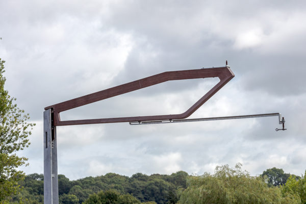
See Prototype Overhead Line Structure Revealed for more details on these gantries.
An Oxford And Stratford-upon-Avon Service
My estimates for the timings of the two sections of the route are as follows.
- Stratford-upon-Avon and Honeybourne – 20 minutes
- Honeybourne and Oxford – 46 minutes
Perhaps not the best for an efficient services, but I’m sure something could be arranged.
Conclusion
This will be a difficult project to get built.
If it is built, I suspect, it will be a passenger-only route using battery trains.
Beeching Reversal – Stockport And Ashton Line
This is one of the Beeching Reversal projects that the Government and Network Rail are proposing to reverse some of the Beeching cuts.
I came across this railway, when I was writing Macclesfield Station And High Speed Two, as I felt the Stockport and Stalybridge Line could be a useful connection to the proposed High Speed Two terminus at Macclesfield station.
This article on the Quest Media Network is entitled Proposals For New Rail Link Between Ashton And Stockport.
This paragraph described the political backing.
The Labour politicians are backing a bid to the ‘Restoring Your Railway Fund’, which will distribute £500 million of funds to reinstate axed local services and restore stations.
The bid was put forward by Transport for Greater Manchester (TfGM) and Stockport Council, but also has the backing of Tameside Council.
Not fans of Boris, I would presume!
These paragraphs describe the proposals
It proposes two options – a heavy rail service between Stockport and Manchester Victoria via Denton and Reddish South, and a light rail service connecting with the existing Manchester-Ashton Metrolink line at Ashton Moss in the north, and with the proposed Stockport-East Didsbury line in the south.
The proposals also open possibilities of new stations along the line at Audenshaw, Thornley Lane and Heaton Norris.
These are my thoughts.
Macclesfield As A Terminal
As I said in conjunction with High Speed Two, I believe that Macclesfield station would make a good terminal, where a Stockport-facing platform could be built, which would give step-free access to the hourly High Speed Two train to Stoke, Stafford and London.
Manchester Victoria And Stockport
This route map, which has been clipped from Wikipedia, shows the route between Manchester Victoria and Stockport stations.
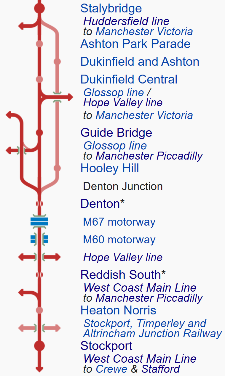
Note.
- The connection to Manchester Victoria station joins at Denton Junction.
- There are possible stations at Denton, Reddish South and Heaton Norris.
- Trains to Macclesfield station take the West Coast Main Line from Stockport station.
- At Stalybridge there is a connection to the Huddersfield Line for Huddersfield and Leeds.
Realtimetrains devolves this extra information.
- Manchester Victoria and Stockport are twelve miles apart via Denton.
- It is a busy freight route with upwards of a couple of trains per hour (tph)
- There used to be a station at Miles Platting.
It is a comprehensive route and deserves a lot more than a simple hourly service to Manchester Victoria station.
Battery Electric Trains
Consider.
- Macclesfield, Manchester Victoria and Stockport stations are all fully electrified.
- About twelve miles of track are not electrified.
- Manchester Victoria and Macclesfield stations are twenty-four miles apart.
- I estimate a four-car 100 mph battery electric train like a Class 350 train would do the trip in close to 25 minutes.
It looks like an ideal route for a battery electric train to me.
Two trains would be needed to run a two tph service, with no extra infrastructure.
Conclusion
Develop a service between Manchester Victoria and Macclesfield stations using battery electric trains, with at least a frequency of two tph.
Beeching Reversal – Restoring A South Humber Link
This is one of the Beeching Reversal projects that the Government and Network Rail are proposing to reverse some of the Beeching cuts.
The project is described by these two paragraphs in this article in the Yorkshire Post, which is entitled Government Announce Yorkshire Rail Schemes That Could Receive ‘Reverse Beeching’ Funding.
North Lincolnshire Council have bid for funding to subsidise a new train service that would allow passengers from Barton-on-Humber to travel to Gainsborough, from where they would be able to catch direct services to Sheffield.
This would be achieved by diverting the existing Barton to Grimsby and Cleethorpes trains up a freight-only section used by traffic heading to Immingham docks. There have never been passenger trains using this path before.
This rail map clipped from Wikipedia shows the Barton Line to Barton-on-Humber station.
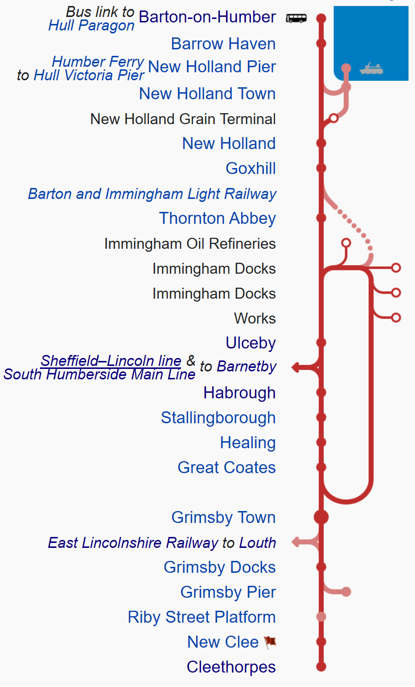
Note.
- Barton-on-Humber station has a bus link to Hull station.
- The loop gives a grand tour of the Port of Immingham on what is now a freight-only line.
- There is a lot of development going on in the area including the AltAlto aviation biofuel, that I wrote about in Grant Shapps Announcement On Friday.
Perhaps all this development is causing a lot of small problems.
- Is it causing congestion on the roads?
- Are workers difficult to find in the Immingham area?
- Is commuting over the Humber Bridge expensive?
- Is parking difficult in the Port?
North Lincolnshire Council could feel that a better rail connection serving the Port of Immingham, would be an asset, that reduces these problems.
I suspect the current two-hourly service between Barton-on-Humber and Cleethorpes stations, will be replaced by an hourly one, between Barton-on-Humber and Gainsborough Lea Road stations, that takes the following route.
- Barton-on-Humber to Ulceby
- At Ulceby station the train will reverse and go clockwise around the loop.
- After calling at Great Coates, Healing, Stallingborough and Habrough stations, the train would go West to Barnetby and Gainsborough Lea Road stations.
- Passengers wanting to go from Barton-on-Humber to Grimsby Town or Cleethorpes, would change at Great Coates station.
It may look a rather round-about route, but I suspect that the plan includes some stations to serve the Port of Immingham and the industrial development.
I suspect that some of these port, oil, chemical and energy companies can afford to pay a contribution.
Gainsborough Lea Road Station
Gainsborough Lea Road station is a mix of architectural styles.
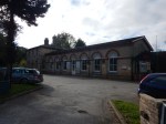
But with the addition of a friendly café and some other facilities, it would be a good interchange between the Immingham area and Sheffield and the county town of Lincoln.
Future Trains
Lincolnshire is an energy-rich county, which partly explains all the industrial development in the North-East of the county around Grimsby, Immingham and Scunthorpe.
- Immingham is a large importer of biomass for power generation.
- There are off-shore and on-shore gas fields connected to Theddlethorpe gas terminal.
- There is the large power station complex at Keadby.
But the energy mix is a-changing.
- Keadby now includes a solar farm.
- Wind turbines are springing up both on land and in the sea.
If I was to make a prediction, it would be that more and more large energy-related businesses will develop in the area.
- In recent months, Altalto’s waste-to-aviation biofuel plant has been given national and local government backing to be built at Immingham.
- ITM Power are involved in a hydrogen development project in the area.
- I wouldn’t be surprised to see hydrogen produced for transport from all this energy.
I think it will be inevitable, that zero-carbon battery electric or hydrogen-powered trains will run in the area.
- Cleethorpes and Doncaster via Scunthorpe 52 miles apart.
- Cleethorpes and Barton-on-Humber are 23 miles apart
- Lincoln and Newark are 16.5 miles apart.
- Lincoln and Doncaster are 37 miles apart.
- Lincoln and Sheffield are 48 miles apart
- Lincoln and the electrification at Peterborough are 54 miles apart.
- Skegness and Sleaford are 41 miles apart.
- Sleaford and Grantham are 18 miles apart.
With charging facilities at Barton-on-Humber, Lincoln, Skegness and Sleaford, the whole of Lincolnshire could be served by zero-carbon battery electric trains.
I suspect LNER could lead the way, as a five-car Class 800 train equipped with batteries, is predicted to have a 56 mile range away from the wires, which would easily handle a return trip between Newark and Lincoln.
There could be a small problem, in that the first train of the day, between Lincoln and London Kings Cross positions from Doncaster Carr IEP Depot, so running Doncaster to Newark via Lincoln might challenge the battery range of the train. I suspect, that the positioning could be performed via Newark with a reverse, prior to the installation of a charging facility at Lincoln Central station.
I estimate that Barton-on-Humber and Gainsborough Lea Road stations are about 35 miles apart, so with today’s battery technology, I suspect that a round trip in a battery electric train would be on the limit. But with charging facilities at Gainsborough, there would be no problems.
I suspect that East Midlands Railway would use several of their forty diesel Class 170 trains on this and other routes in Lincolnshire, so perhaps a good interim solution would be to run the Class 170 trains on Altalto’s biodiesel, that will be produced at Immingham.
There is also the possibility, that some or all of the Class 170 trains will be retrofitted with MTU Hybrid PowerPacks, which would cut their diesel consumption.
Surely, with all Lincolnshire’s energy, hydrogen-powered trains must be a possibility. But they seem to be stuck in a siding!
The MTU Hybrid PowerPack and Altalto’s bio-diesel seems a more affordable and less risky route.
A Direct Connection To London
In the Wikipedia entry for Gainsborough Lea Road station, there is a section called Future Services, where a direct connection to London is mentioned.
Conclusion
Given that the likes of East Midlands Railway, Hull Trains, LNER and TransPennine Express are improving their services to Hull, Lincoln, Cleethorpes and Grimsby, this local North Lincolnshire Metro serving the Port and the industrial development, could well be welcomed by those that live and work in the area.
I doubt that the infrastructure cost will be very high.
Beeching Reversal – Sheaf Valley Stations
This is one of the Beeching Reversal projects that the Government and Network Rail are proposing to reverse some of the Beeching cuts.
Stations To Be Rebuilt
As you approach Sheffield station, you pass four station sites, three of which are demolished and the fourth is just a shadow of its former self.
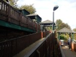
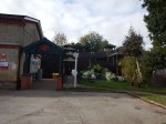
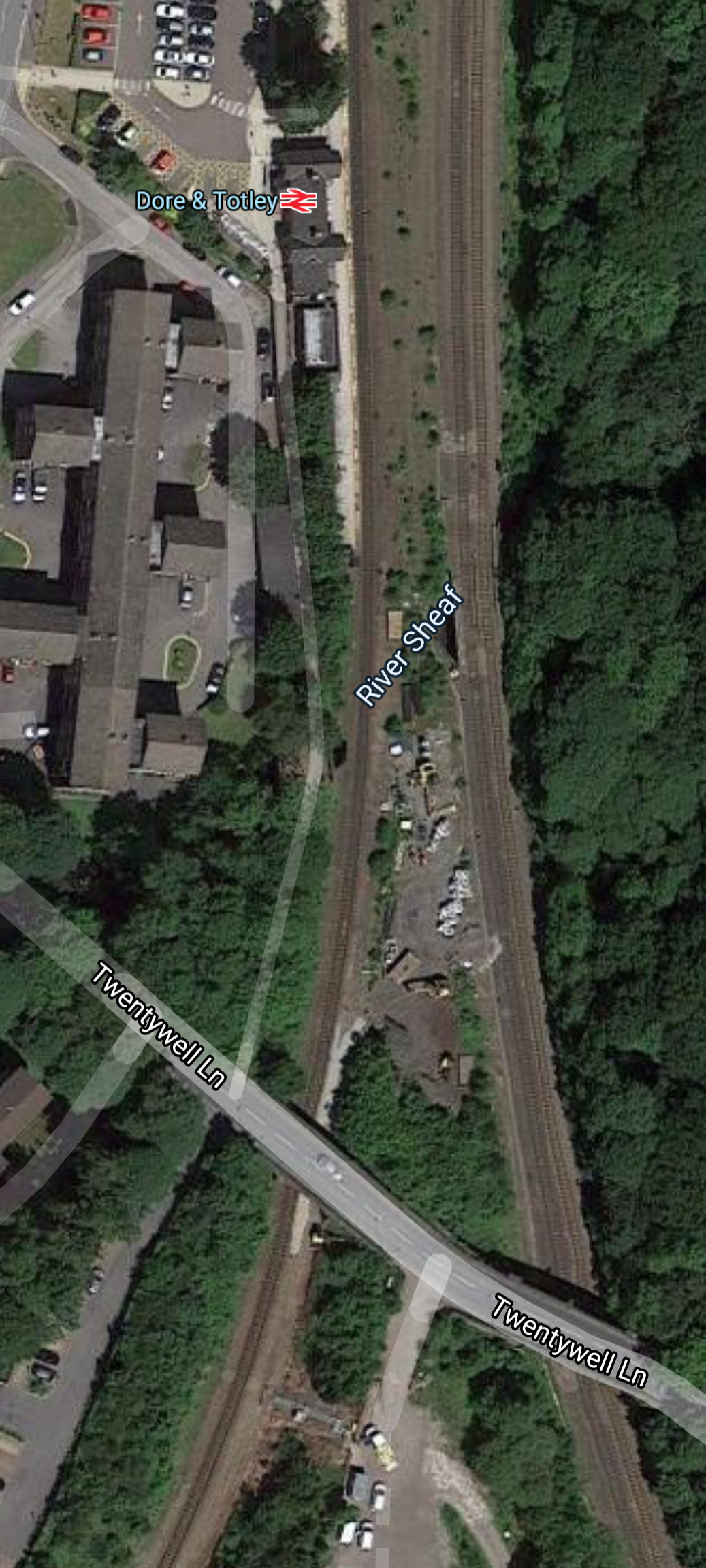
Dore & Totley
Dean & Totley station used to have four platforms and this Google Map, shows what is left after British Rail’s vandalism in the mid-1980s.
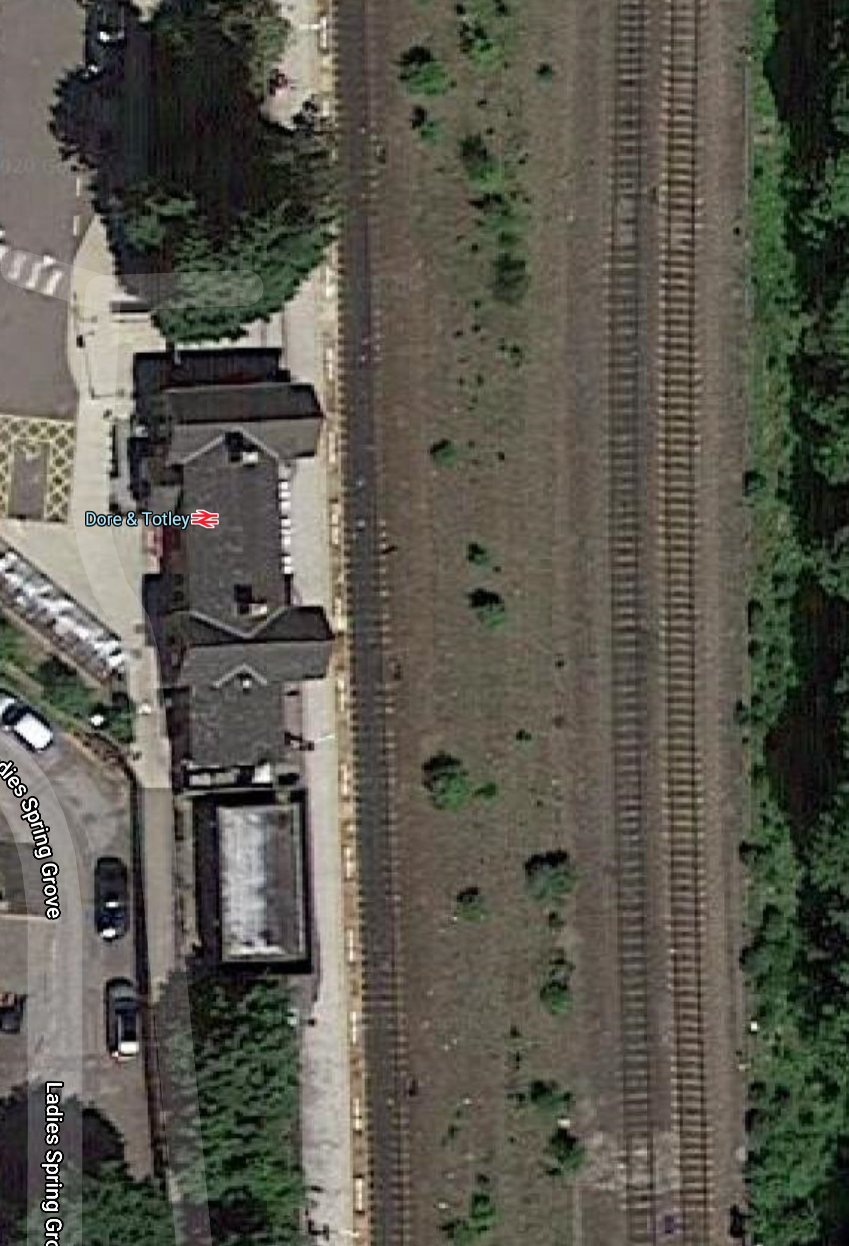
Note.
- The station has only one platform.
- The single track in the platform handles all trains to and from the Hope Valley Line.
- At present it appears to be two trains per hour (tph) in both directions.
- The two tracks at the right are the Midland Main Line.
Transport for the North wants to run four tph between Manchester Piccadilly and Sheffield through here, that will take forty minutes between the two cities.
Updates planned for the station include.
- A second platform for Manchester-bound trains.
- A new bridge with lifts.
- Platforms long enough to take a pair of Class 185 trains or a five-car Class 802 train.
- A full hourly service.
There certainly seems to be enough space for another platform and track through the middle of the station.
At some point in the near future, the two Midland Main Line tracks will be electrified, as part of the upgrade for High Speed Two.
Between Dore & Totley And Beauchief
This Google Map shows a typical section of the line between Dore & Totley and Beauchief stations.
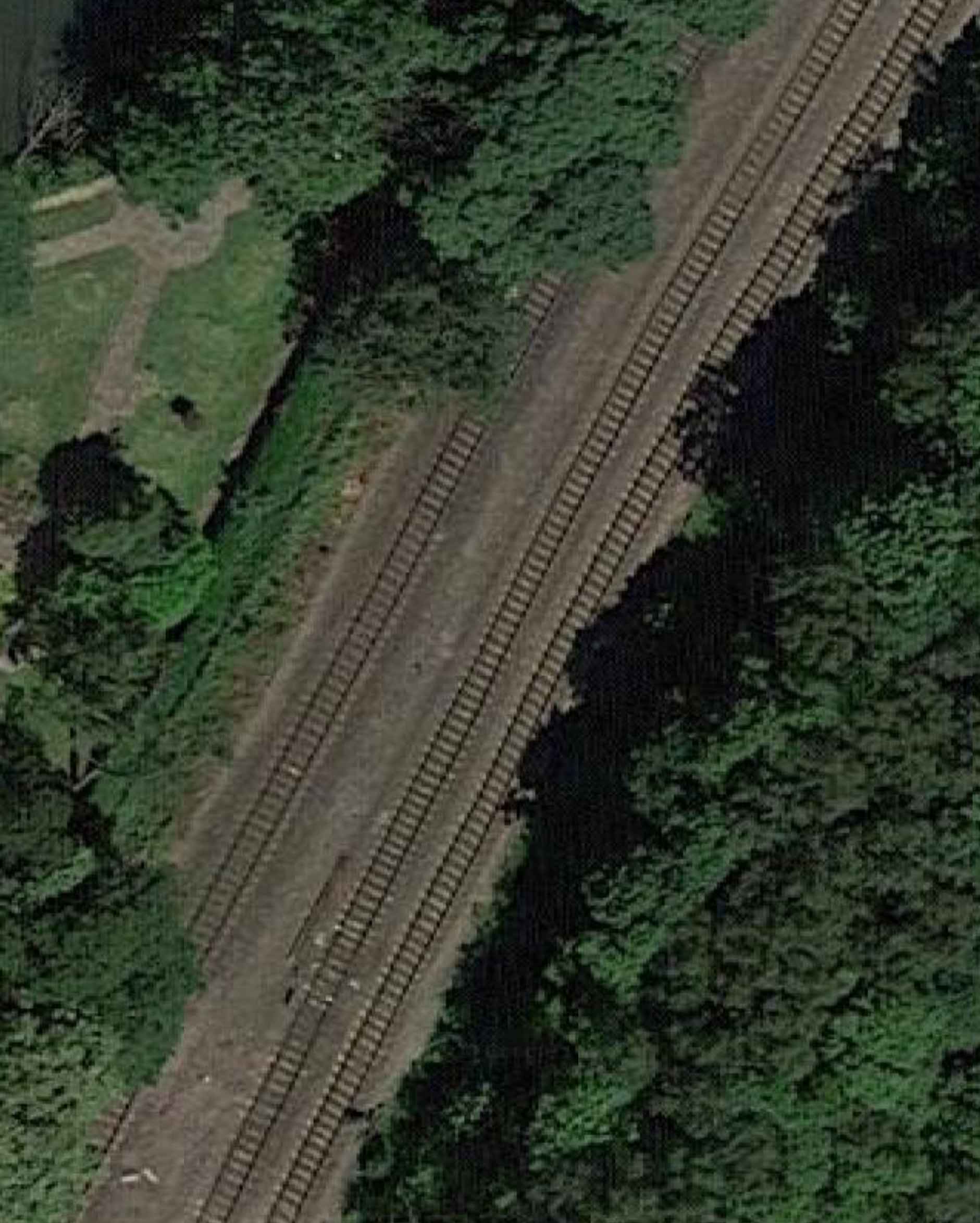
Note the two Midland Main Line tracks on the right and single-track to the Hope Valley Line on the left.
It would appear that the fourth track can be squeezed in between the single track and the Midland Main Line.
Beauchief
Beauchief station used to have four platforms before it was demolished.
This Google Map shows the station’s former location.
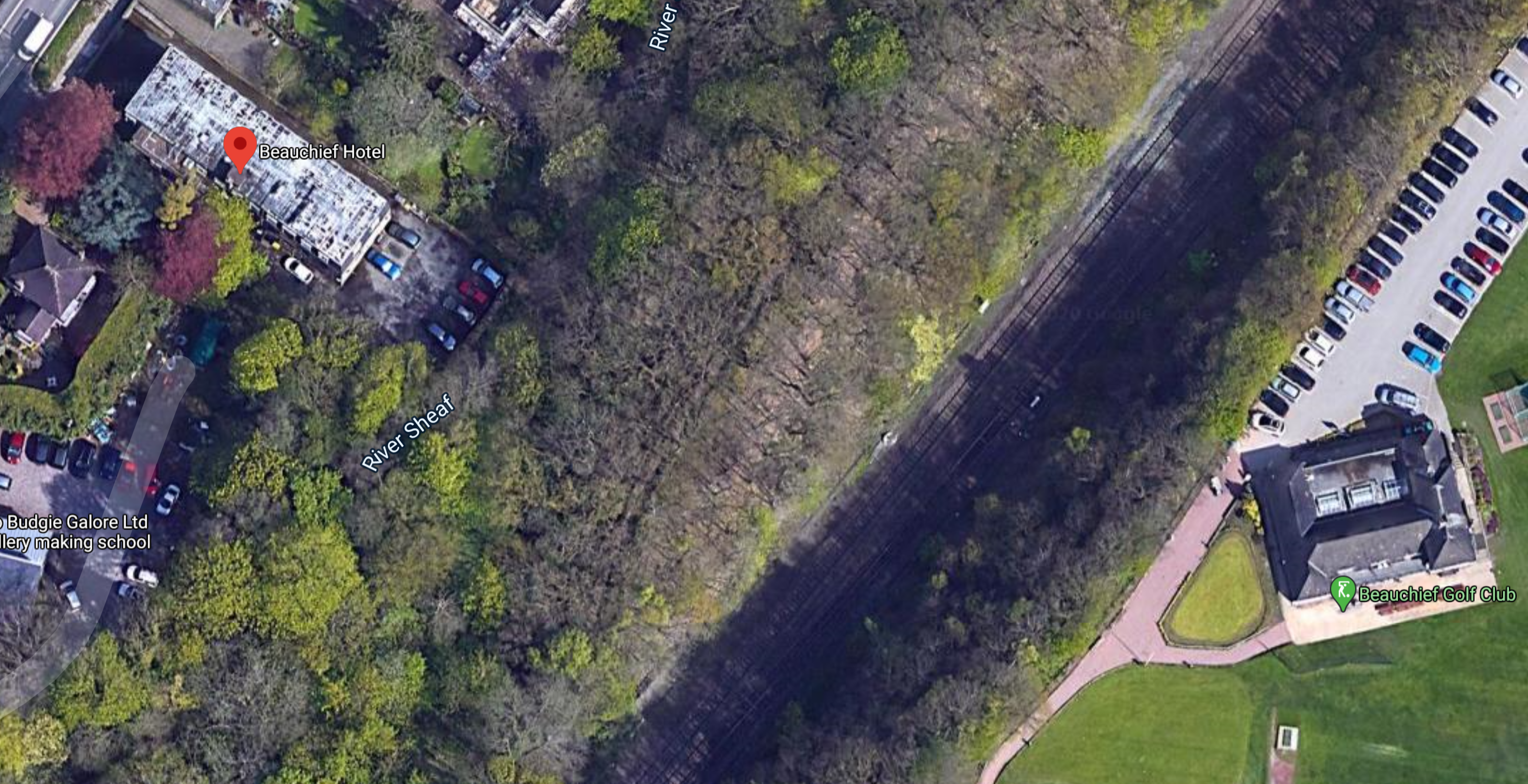
Note.
- The building with the red dot is the former Beauchief Hotel. which was by the station.
- On a larger screen you can see three tracks going into Sheffield.
I’m fairly certain that four tracks and two platforms for a station can be fitted into this narrow trackbed.
Millhouses & Eccleshall
Millhouses and Eccleshall station used to have four platforms before it was demolished.
This Google Map shows the station’s former location.
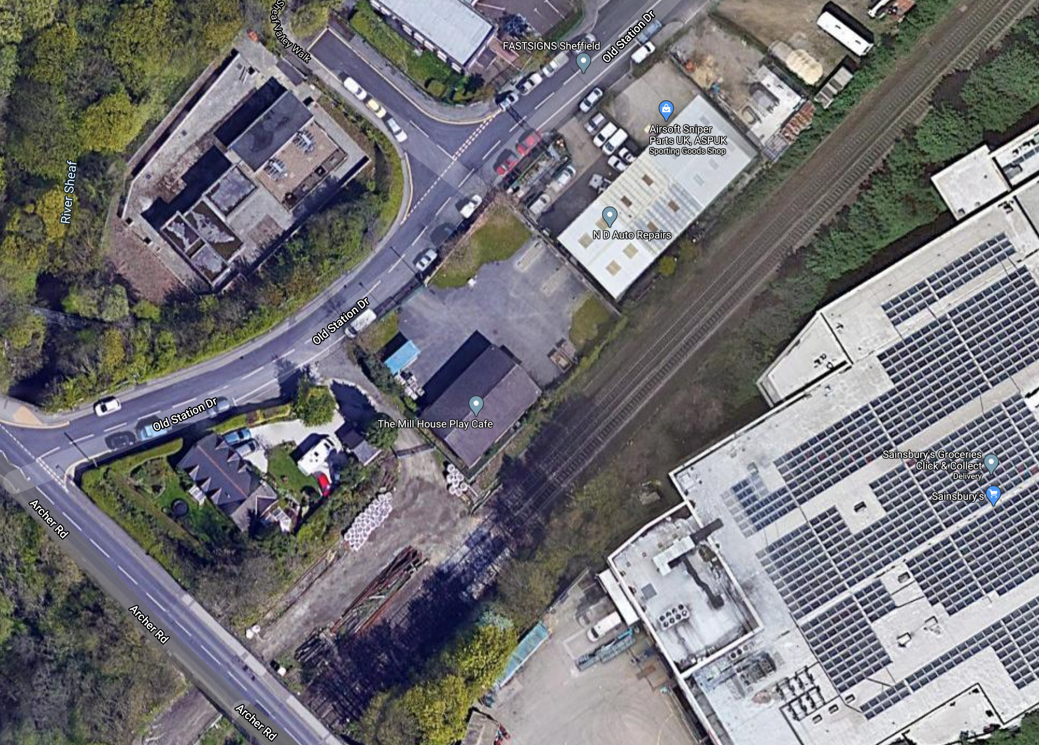
Note.
- Wikipedia says the station was accessed from the Archer Road bridge, which is in the South East corner of the map.
- It looks like there are three tracks with space for four.
- The road to the North-West of the railway is called Old Station Road.
As at Beauchief, it will be tight.
Heeley
Heeley station used to have four platforms before it was demolished.
This Google Map shows the station’s former location.
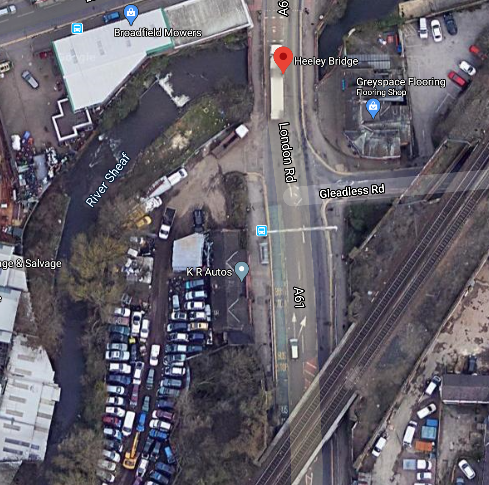
Note.
- The red arrow indicates Heeley Bridge, which Wikipedia says is near the station site.
- There appears to be only two tracks through here.
It is easy to follow the tracks from here to Sheffield station.
Could A Four Track Railway Be Rebuilt Between Dore & Totley And Sheffield Stations?
I’ve not seen anything that says that building a four-track railway through here is not possible.
In a few years, there could be the following tracks and platforms, on this section.
- Two fast tracks for High Speed Two, Midland Main Line and CrossCountry trains, that will be electrified with 25 KVAC overhead electrification, between Clay Cross North Junction and Sheffield station.
- The High Speed Two trains will be classic-compatible and up to 200 metres long.
- The two fast tracks will not have any platforms.
- Two slow tracks for local services, that will be appropriately electrified.
- The slow tracks will have step-free platforms, that will be long enough to take a five-car Class 802 train or a pair of Class 185 trains.
I can’t for the life of me understand, why this stretch of four-track main line between Dore & Totley and Sheffield stations was ever simplified, as at other places on the UK network, extra tracks were being added to the main lines, at the same time.
Future Services On The Fast Lines
Currently, the following services take the fast lines between Sheffield and Chesterfield stations via Dore & Totley station.
- East Midlands Railway – Sheffield and London St. Pancras – 2 tph
- East Midlands Railway – Sheffield and Norwich via Nottingham – 1 tph
- CrossCountry – Edinburgh/Newcastle and Derby/Birmingham and the South – 2 tph
- Northern – Sheffield and Nottingham – 1 tph
That is a very modest six tph.
High Speed Two are currently planning to run two tph between Sheffield and London Euston.
There may or may not be other changes.
- As Birmingham Curzon Street and Sheffield will be just forty-seven minutes by High Speed Two all the way, will these destinations have a direct high speed classic-compatible service? There’s plenty of space capacity on High Speed Two.
- I don’t think the Sheffield and St. Pancras services will be dropped, but they might be.
- CrossCountry will probably be running intelligent multi-mode trains capable of 125 mph running and up to 140 mph in places.
- Northern’s service between Sheffield and Nottingham might go via a reopened Barrow Hill Line.
But the biggest change will be that these two fast lines will be to High Speed Two standards.
- Sheffield and Chesterfield will be electrified.
- There will in-cab digital signalling, which theoretically could probably allow eighteen tph on the route.
- High Speed Two Trains between Sheffield and Chesterfield will take twelve minutes.
- Sheffield station will have been modified as required, to be able to handle all trains very efficiently.
But it would still be carrying a modest eight tph.
If required Sheffield would have the capacity to accept more trains from the South.
I wouldn’t be surprised to see, the following trains added.
- An extra tph to and from London Euston via High Speed Two.
- Two tph to and from Birmingham Curzon Street via High Speed Two.
I also wouldn’t be surprised to see CrossCountry using classic-compatible High Speed Two trains and switching to High Speed Two between Birmingham New Street and Sheffield. But these trains would still use the same tracks to access Sheffield station.
But I am led to the conclusion, that Sheffield will have more than enough capacity linking the City to Chesterfield and the South.
Future Services On The Slow Lines
Or should I use lines connecting to the Hope Valley Line rather than slow lines?
Currently, the following services take the slow lines between Sheffield and Dore & Totley stations.
- East Midlands Railway – Liverpool Lime Street and Sheffield – via Manchester Piccadilly – 1 tph
- TransPennine Express – Manchester Airport and Cleethorpes via Manchester Piccadilly – 1 tph
- Northern – Sheffield and Manchester Piccadilly – 1 tph
Transport for the North aims to run a four tph service with a forty minute journey time between Manchester Piccadilly and Sheffield.
Consider.
- 100 mph TransPennine Express trains take fifty-three minutes between Sheffield and Manchester Piccadilly without a stop.
- Classic-compatible trains with a battery capability could easily handle the route.
- Northern’s services on the Hope Valley Line are timed for 75 mph trains.
- Dore & Totley and Hazel Grove stations are twenty-nine miles apart.
If between Dore & Totley and Sheffield stations were to be electrified and track improvements like passing loops were to be made to the Hope Valley Line, I believe that to achieve a forty minute all-stops timing between Sheffield and Manchester Piccadilly, would need a train with the following specification.
- Electric train with batteries.
- Four cars
- 100 mph or faster operating speed.
- Step-free access between platform and train.
- Sparkling acceleration and deceleration.
- Ability to run under in-cab digital signalling to keep out of the way of freight services.
Looking at Crossrail between London Paddington and Maidenhead stations, the London route is probably as difficult as the Hope Valley Line and it has been designed as a forty minute service with ten stops, using a modern electric train.
If TransPennine fitted batteries to their Class 802 trains, these trains would fit the Northern Powerhouse Rail requirements.
East Midlands Railway and Northern would find that the following trains could be used.
- Bombardier – Aventra with batteries
- Bombardier – Class 377 train with batteries
- Bombardier – Class 379 train with batteries
- CAF – Class 331 train with batteries
- Hitachi – Class 385 train with batteries
- Porterbrook – Battery/FLEX train based on Class 350 train
- Stadler – Flirt with batteries
All would need that between Dore & Totley and Sheffield stations be electrified.
After the upgrades and the new or refurbished trains are running, this would mean that between Dean & Totley and Sheffield would be handling four tph, which would be semi-fast trains between Sheffield and Manchester Piccadilly. Although to current passengers on the line, they would seem to be fast services of a much higher standard.
It would not be very different to how the slow lines into Paddington also handle about four tph of other services, including GWR services and freight.
I believe that to provide an adequate service to the reopened and rebuilt stations of Dore & Totley, Beauchief, Millhouses & Eccleshall and Heeley, that a Turn-Up-And-Go service of at least four tph should be run between Dore & Totley and Sheffield stations.
A Turnback At Dore & Totley
This Google Map shows Dore & Totley station and the area to the South.
Note.
- There would appear to be a lot of space between the Midland Main Line and the single track, that leads between Dore & Totley station and the Hope Valley Line.
- Flying my helicopter, as low as I dare, it looks like the area is either a rubbish dump or very low grade businesses.
- Crossrail has designed turnbacks at Abbey Wood and Paddington stations, that will handle twelve tph.
I believe that it would be possible to design a turnback at Dore & Totley station, that would handle eight trains per hour, if not twelve tph.
It might even be possible to squeeze in some overnight stabling.
Trains Or Tram-Trains Between Dore & Totley And Sheffield Stations
In my view, it doesn’t matter.
Crossrail’s 12 tph turnbacks can handle a 205 metre long Class 345 train, so I’m sure a well-designed turnback at Dore & Totley could handle a mixture of any trams or tram-trains below a defined maximum length of say 140 metres, which would be defined by a pair of Class 185 trains, which might have to be turned back during service disruption.
Where Would The Services Terminate in The East?
It is my view that cross-city services like Birmingham’s Cross-City Line, Liverpool’s Northern Line, London’s Crossrail and Thameslink, Newcastle’s Metro and Paris’s RER are efficient for both passengers and train operators.
So Dore & Totley station could be one end of a Sheffield cross-city line, with a frequency of at least eight tph through Beauchief, Millhouses & Eccleshall, Heeley and Sheffield stations.
So where would services go on the other side of Sheffield? Wikipedia gives these as services to the East of Sheffield.
- Leeds via Barnsley and Wakefield (fast) – 2 tph
- Leeds via Meadowhall, Barnsley, Wakefield and Castleford (stopping). – 1 tph
- Leeds via Meadowhall, Moorthorpe and Wakefield. – 1 tph
- Scarborough via Meadowhall, Doncaster, Hull and Bridlington. – 1 tph
- Lincoln Central via Worksop and Retford – 1 tph
- Gainsborough Central via Worksop, three trains per week continue to Cleethorpes via Brigg. – 1 tph
- Huddersfield via Meadowhall, Barnsley and Penistone – 1 tph
- Doncaster via Meadowhall and Rotherham, with one train per hour continuing to Adwick – 2 tph
- York via Moorthorpe and Sherburn-in-Elmet. – 3 trains per day (tpd)
For much of the day, that is a frequency of 10 tph, with 5 tph calling at Meadowhall, 2 tph calling at Worksop and two fast tph passing Meadowhall without stopping.
But there are other rail projects under development.
- High Speed Two will enable a new fast service between Sheffield and Leeds via Meadowhall and a new station in the Dearne Valley.
- The Sheffield Region Transport Plan 2019 envisages a new station at Barnsley Dearne Valley. See Sheffield Region Transport Plan 2019 – A New Station At Barnsley Dearne Valley.
- The Sheffield Region Transport Plan 2019 envisages tram-trains running between Sheffield and Doncaster-Sheffield Airport See Sheffield Region Transport Plan 2019 – Tram-Trains Between Sheffield And Doncaster-Sheffield Airport.
- The Sheffield Region Transport Plan 2019 envisages a new Station at Waverley. See Sheffield Region Transport Plan 2019 – A New Tram-Train Route To A New station At Waverley.
- High Speed Two might enable a fast classic-compatible service between Sheffield and Scarborough via York.
- The possible opening of the South Yorkshire Joint Railway to passenger traffic, may open up further opportunities. See Beeching Reversal – South Yorkshire Joint Railway.
- The possible reinstatement of the Barrow Hill Line. See Reinstatement Of The Barrow Hill Line Between Sheffield And Chesterfield.
- The development of the Stocksbridge Railway for passenger services.
I can see classic-compatible High Speed Two trains serving the following places to the East of Sheffield.
- Leeds
- Hull via Doncaster
- Scarborough via York
- Cleethorpes via Doncaster, Scunthorpe and Grimsby.
A train like a five-car Class 802 train would probably be enough for most routes except Leeds.
I can see the following terminals for tram-trains to the East of Sheffield.
- Doncaster and Doncaster-Sheffield Airport
- Waverley station, which could be on a loop from the Sheffield and Lincoln Line.
- Barnsley Dearne Valley
There may well be others.
If Sheffield were Karlsruhe in Germany, the tram-trains would probably serve the following routes.
- Huddersfield via Penistone.
- Lincoln via Worksop and Gainsborough.
- Manchester via the Hope Valley Line.
But the Germans have a much larger electrified core, than Sheffield will have, even if High Speed Two electrifies between Dore & Totley and Thurnscoe stations via Sheffield.
I can make a table of destinations and distances and how they could be served.
- Barnsley – 16 miles – Possible return trip from Sheffield for a battery electric train.
- Barnsley Dearne Valley – 8 miles from Rotherham Parkgate – Possible return trip from Sheffield via Rotherham Parkgate for a battery electric tram-train.
- Doncaster – 11 miles from Rotherham Parkgate – Possible return trip from Sheffield via Rotherham Parkgate for a battery electric tram-train.
- Chesterfield via Barrow Hill – 17 miles – Possible return trip from Sheffield for a battery electric tram-train.
- Doncaster Sheffield Airport – 10 miles from Doncaster – Possible return trip from Sheffield via Rotherham Parkgate and Doncaster for a battery electric tram-train.
- Gainsborough Lea Road. – 32 miles – See Lincoln Central.
- Huddersfield – 36 miles – Possible battery electric train with charging at Huddersfield.
- Hull – 59 miles – Possible battery electric train with charging at Doncaster and Hull.
- Lincoln Central – 48 miles – Possible battery electric train with charging at Lincoln and/or Gainsborough Lea Road. Otherwise diesel.
- Penistone – 23 miles – Possible return trip from Sheffield for a battery electric train, using Newton’s friend on the way back.
- Retford – 23 miles – Possible return trip from Sheffield for a battery electric train.
- Waverley – About 6 miles – Possible return trip from Sheffield for a battery electric tram-train.
- Worksop – 16 miles – Possible return trip from Sheffield for a battery electric train.
It looks to me like a mix of battery electric trains and tram-trains could run most of the services from Sheffield, if services that used new High Speed Two infrastructure used classic-compatible trains or trains like the existing Class 802 trains, that have been converted to battery electric operation.
Note.
- I am assuming, that a battery electric train has a range of 56 miles on a single charge.
- Rotherham Parkgate station is changed to a through station.
- Tram-trains passing through Doncaster can recharge on the station’s 25 KVAC overhead electrification.
- Charging can be provided as required at other stations.
There are lots of possibilities.
Consider, this for tram-train extensions to Barnsley Dearne Valley, Doncaster and Doncaster Sheffield Airport.
- Extend the tram-train service at Rotherham Parkgate to either Doncaster and Doncaster Airport or Barnsley Dearne Valley stations.
- Run tram-trains between Dore & Totley and Rotherham Parkgate via Sheffield, Meadowhall and Rotherham Central.
This would give a double-ended route across Sheffield and Rotherham between Dore & Totley and the existing Supertram network in the West and Barnsley Dearne Valley, Doncaster and Doncaster Sheffield Airport in the East.
Consider how to connect the branch to Waverley station to the Supertram network.
- Waverley station will be either on or on a loop from the Sheffield and Lincoln Line.
- The Sheffield and Lincoln Line has no obvious connection with the Supertram network.
- The Sheffield and Lincoln Line goes straight in to Sheffield station.
- Trains to Lincoln always appear to use Platform 4 in Sheffield station.
- Sheffield station has four through platforms.
This Google Map shows where the Sheffield and Lincoln Line passes behind the Supertram Depot at Nunnery.
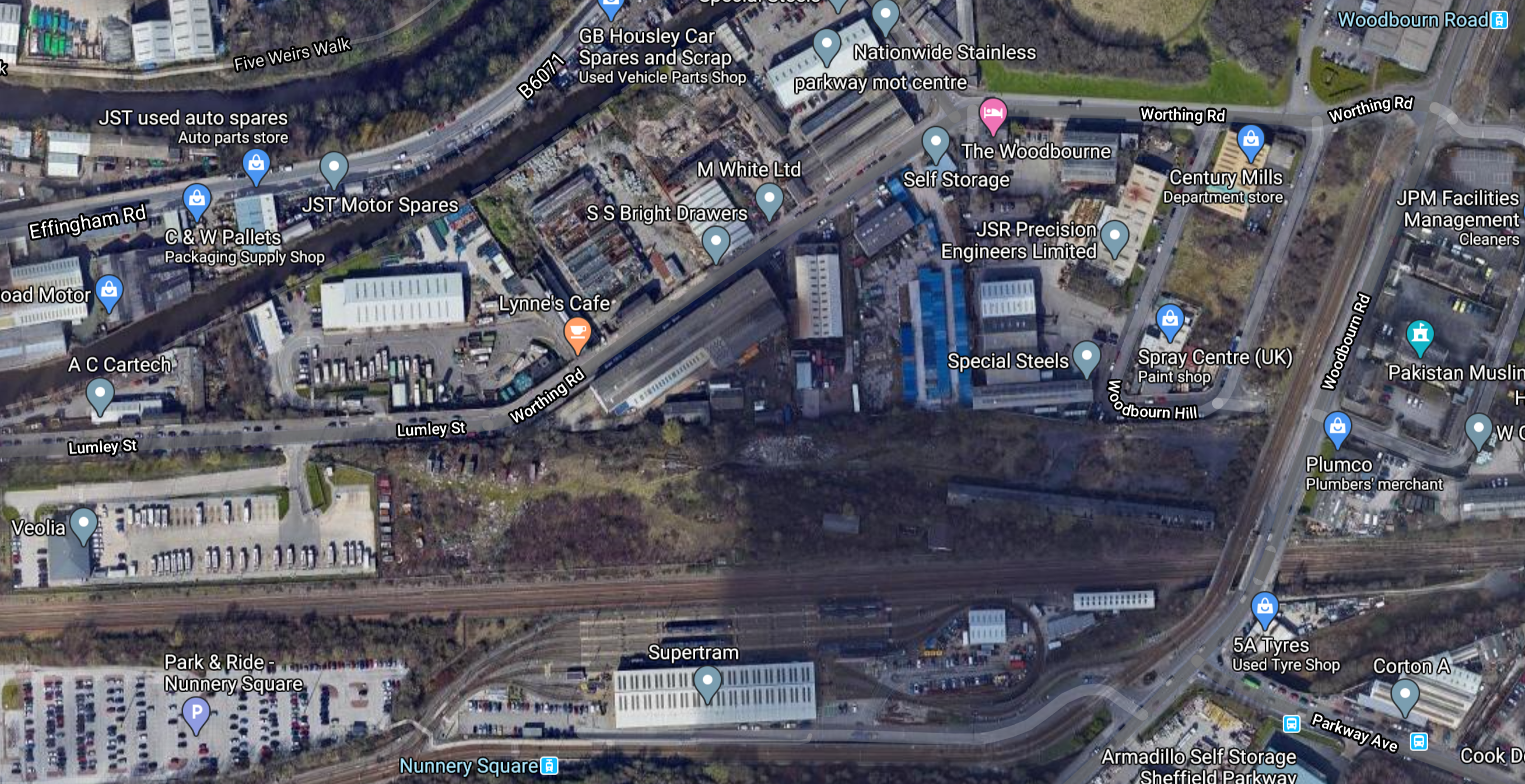
Note.
- The Nunnery Square Park and Ride is in the South West corner of the map.
- The Supertram depot is to the East of the Park-and-Ride, with the Nunnery Square tram stop to the South.
- The Woodbourn Road tram stop is in the North East corner of the map.
This second Google Map shows the lines around the Park-and-Ride.
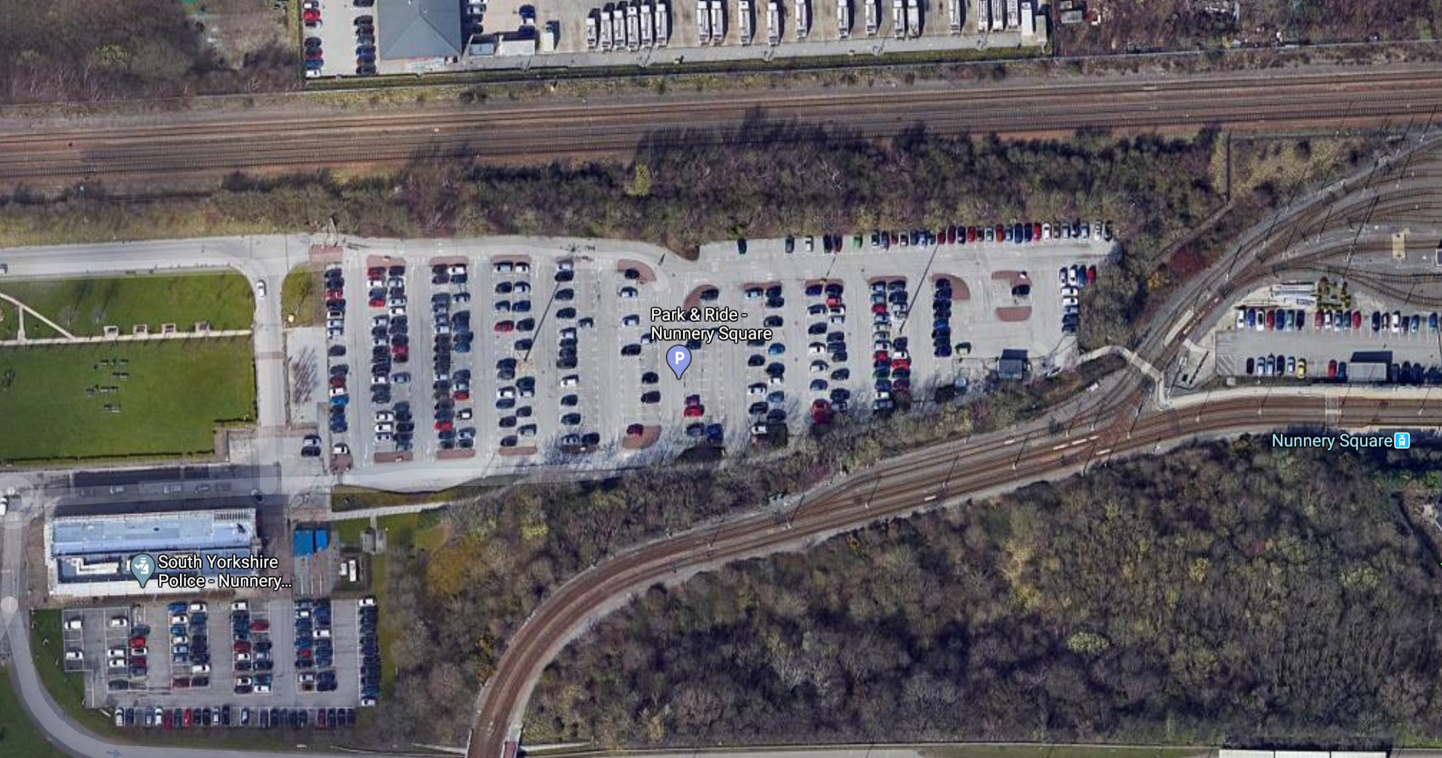
I suspect that a connection between the Supertram system and the Sheffield and Lincoln Line, could be built to the North of the Nunnery Depot.
But would it be easier to continue to Sheffield station or pass through the station and terminate at Dore & Totley station?
I can’t be sure looking at the maps, but it could be logical that trains to and from Lincoln use the Southern pair of tracks past the Nunnery Depot, as they would be on the right side of the tracks for Lincoln.
This would make it easier to do the following.
- Create a connection between the Nunnery Depot and the Sheffield and Lincoln Line, which would surely be needed for efficient maintenance and operation of tram-trains running to and from Waverley.
- Allow tram-trains used to serve the proposed Waverley station to return to the Depot every night.
- Allow tram-trains working between Sheffield and Meadowhall to use the Lincoln and Sheffield Line to enter the Nunnery Depot.
- Build a tram stop/station by the Park-and-Ride.
There would also be less need to build another depot.
Looking at the maps, could there be space to extend the Nunnery Depot?
Conclusion
This could be a very good project.
- It fits in well with the plans and needs of High Speed Two.
- It connects the new Waverley station to Sheffield station.
- It fits well with the Sheffield Region Transport Plan 2019.
- It connects Sheffield, Rotherham and Doncaster to Doncaster Sheffield Airport.
- It opens up the Hope Valley Line to improve services between Manchester and Sheffield.
I also don’t think, there’s any great risk!
I
Beeching Reversal – A New Station At Waverley In Sheffield
This is one of the Beeching Reversal projects that the Government and Network Rail are proposing to reverse some of the Beeching cuts.
In July 2019, I covered this new station in Sheffield Region Transport Plan 2019 – A New Tram-Train Route To A New Station At Waverley.
Note that to avoid confusion, I now refer to this station as Sheffield Waverley station.
This was my conclusion in the July 2019 post.
Why shouldn’t Sheffield have an advanced tram-train system to serve the Advanced Manufacturing Park?
I feel the service should be as follows.
-
- It should be terminated in a loop around the Waverley area and the Advanced Manufacturing Park.
- In the West it could terminate in Sheffield station or perhaps pass through and terminate in the West of the City.
- The service could be run using battery electric tram-trains, similar to the Class 398 tram-trains, that will be used on the South Wales Metro.
I don’t think that the engineering will be very challenging.
I shall be adding to this post.
Beeching Reversal – Reinstatement Of The Beverley And York Rail Line
This is one of the Beeching Reversal projects that the Government and Network Rail are proposing to reverse some of the Beeching cuts.
The York And Beverley Line does what it says in the name.
A section in the Wikipedia entry is entitled Re-Opening Proposals and the treatment of the trackbed after closure would appear to be a case study in how not to mothball a railway.
- The original route has been built on in several places at Huntingdon, New Earswick, Pocklington and Stamford Bridge.
- A new route will have to be built to connect to the York and Scarborough Line at Haxby.
- There may also be problems at Beverley.
The only positive thing I can see, is that York City Council, want to re-open Haxby station. If this station were to be re-opened with a future-proofed design that might help in the wider scheme of reopening the Beverley and York Line.
This Google Map shows the original location of Haxby station.
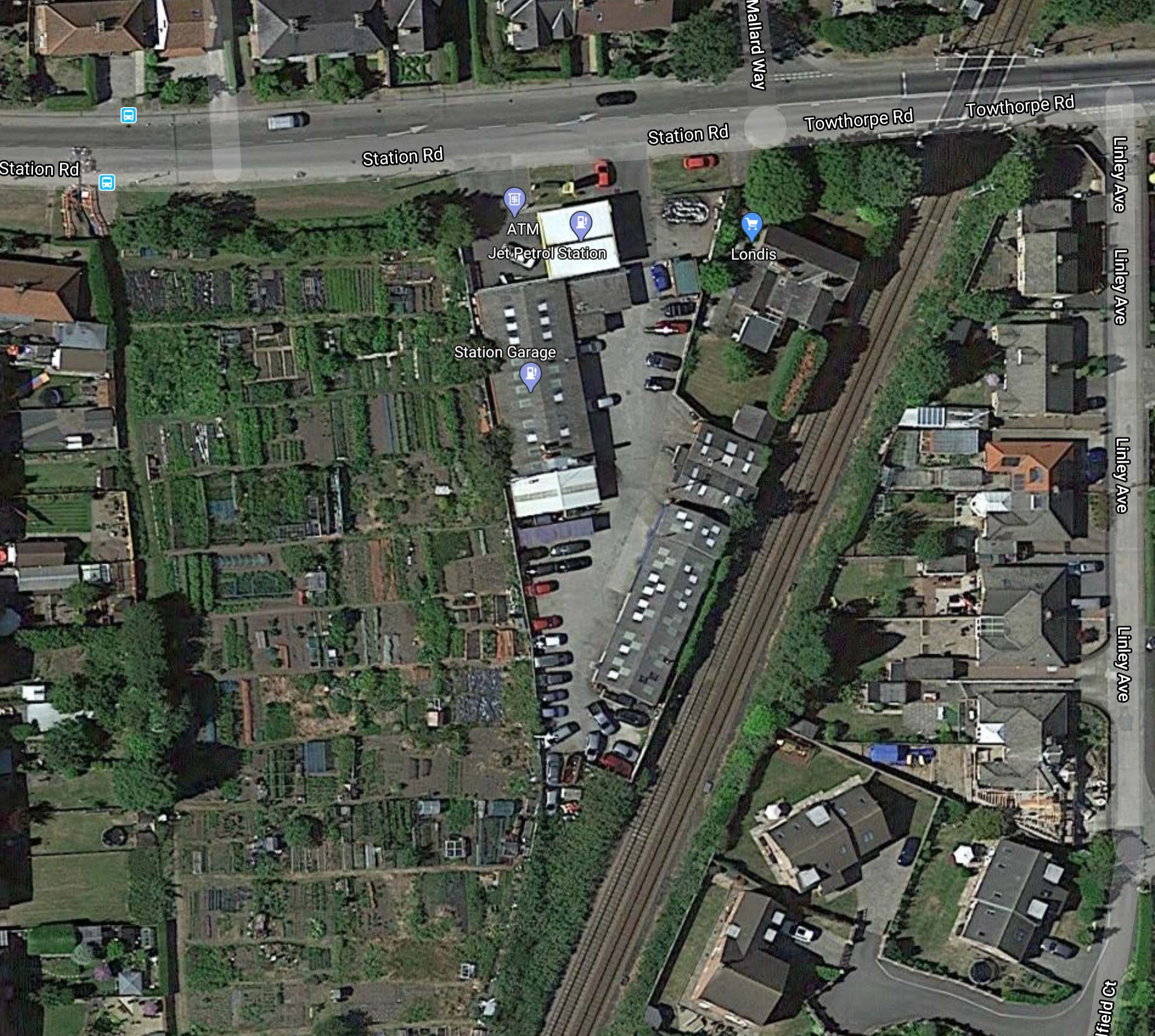
Note.
- There is a dreaded level crossing in the middle of the village, that typically has around two trains per hour (tph)
- The road going to the West at the top of the map, is called Station Road, which is a bit of a giveaway.
- The building on the triangular site is called Station garage.
- Some reports on the Internet say that allotments will be turned into car parks.
- According to Wikipedia 22,000 people live within three miles of the station site.
The station site appears to be hemmed in by housing and comments from readers on one report are complaining about car parking being a problem an definitely don’t want the station.
Wikipedia says this about the proposed service on the Beverley and York Line.
The report recommended reinstating a service from Hull via Beverley, Market Weighton, Stamford Bridge and Pocklington connecting to the York to Scarborough Line at Haxby, on a double track line with a frequency of 2 trains per hour, with intermediate stations only at Market Weighton, Pocklington and Stamford Bridge. The estimate journey time was under 1 hour.
As the Beverley and York Line can’t join the York and Scarborough Line in the middle of Haxby, would it join North or South of the town?
Joining to the North would allow the Beverley trains to call at Haxby, but that would mean the level crossing was busy with six tph.
This Google Map shows the countryside between Haxby in the North and Earswick in the South.
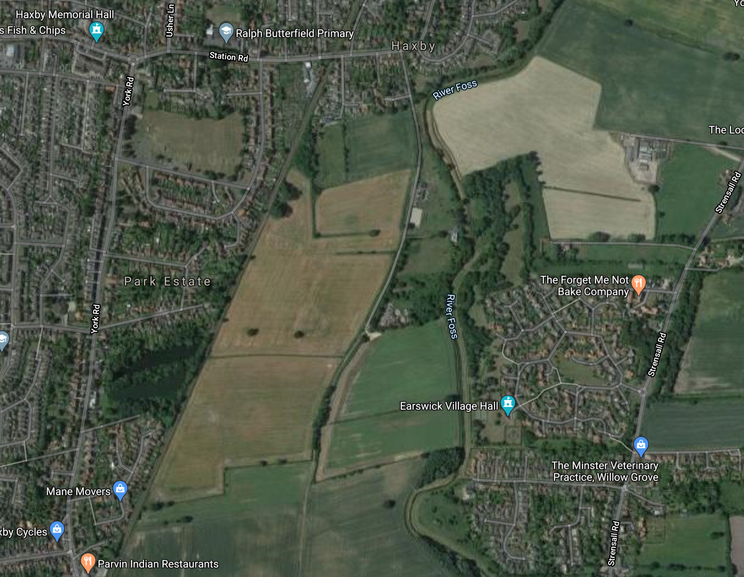
Note.
- The York and Scarborough Line going through the centre of Haxby and then passing down the West side of the light brown fields.
- York is to the South and Scarborough is to the North.
I wonder, if the Beverley and York Line could branch to the East here and skirt to the North of Earswick before continuing to Pocklington for Beverley.
Perhaps, a Park-and-Ride station could be situated, where the railway and the road called Landing Lane cross?
At Beverley, this Google Map shows how the Beverley and York Line connects to the station.
Note.
- Beverley station at the bottom of the map.
- The Hull and Scarborough running North-South through the station.
The line divides by Beverley Rugby Football Club, with the trackbed of the Beverley and York Line going off in the North-Westerly direction.
This seems a lot easier than at the York end of the route.
I have flown my virtial helicopter over much of the route between Beverley and York, and the trackbed is visible but missing in places, where construction has taken place.
Would The Route Be Single Or Double-Track?
The plans call for double track, but would it be necessary?
- There will only be two tph, that will take under an hour.
- No freight trains will use the line.
- The route is 32 miles long.
I suspect a single track would suffice, with a passing loop at Market Weighton station.
Should The Line Be Electrified?
I wouldn’t electrify the whole line, but I would electrify the following.
- Hull and Beverley, so that battery trains to and from London could top up their batteries.
- Haxby and York, so that battery trains to and from Scarborough could top up their batteries.
These two short stretches of electrification would allow battery electric operation between Hull and York, trains could charge their batteries at either end of the route.
Electrification Between Hull And Beverley
Consider.
- Hull Trains extend their London and Hull services to Beverley.
- Hull and Beverley are just over eight miles apart.
- Trains to and from London Kings Cross use the electrification on the East Coast Main Line to the South of Temple Hirst Junction.
- Hull and Temple Hirst Junction are thirty-six miles apart.
- Hull Trains and LNER use Hitachi Class 800 or Class 802 electro-diesel trains on services between London Kings Cross and Hull.
Hitachi’s proposed battery-electric conversion of these trains, would have a range of 56 miles, according to this infographic.

I have flown my helicopter along the route and counted the following.
- Level crossings – 5
- Modern road bridges – 5
- Footbridges – 5
- Other bridges – 5
- Stations – 1
Nothing looked too challenging.
In my view electrification between Hull and Beverley and at convenient platforms at both stations, would be a simple way of decarbonising rail travel between London and Hull.
If this electrification were to be installed, distances from the electrification between Hull and Beverley, these would be the distances to be covered on battery power to various places.
- Bridlington – 23 miles
- Doncaster via Goole – 41 miles
- Leeds – 52 miles
- Neville Hill Depot – 49 miles
- Scarborough – 45 miles
- York – 52 miles
Note.
- All of these places would be in range of a fully-charged Hitachi battery electric train running to and from Hull.
- Of the destinations, only Bridlington and Scarborough, is not a fully-electrified station.
- One of the prerational problems in the area, is that due to a lack of electrification to the East of Neville Hall Depot, electric trains from York and Hull have difficulty reaching the depot. Trains with a battery capability won’t have this problem.
- Hull and Beverley and a lot of stations in the area, would only be served by electric trains, with a battery capability.
There would be a large decrease in pollution and emissions caused by passenger trains in the area.
Electrification Between Haxby And York
Consider.
- York and Haxby are 4 miles apart.
- York and Scarborough are 42 miles apart.
- York and Beverley are 32 miles apart.
Note that unlike at Beverley, there is no need to electrify the end of the route, as trains can be charged in the turnround at York.
With a charging facility at Scarborough, the Class 802 trains of TransPennine Express could work this route if fitted with batteries.
Could Lightweight Electrification Be Used?
Electrification gantries like these have been proposed for routes, where the heavy main-line gantries would be too intrusive.
They could have a place in the rebuilding of lines like Beverley and York.
Trains Between York And Beverley
The UK’s railways need to be decarbonised before 2040.
As a train delivered today, would probably last forty years, I think it would be prudent to only introduce zero-carbon trains to the network, where they are able to run the proposed services.
There is no doubt in my mind, that all these local services in East Yorkshire could be run using battery-electric trains with a 56 mile range.
- Hull and Doncaster
- Hull and Leeds
- Hull and Neville Hill Depot
- Hull and Scarborough
- Hull and York via Beverley and Market Weighton
- Hull and York via Selby
- York and Scarborough
The only electrification needed would be as follows.
Electrification between Hull and Beverley.
Electrification of some platforms at Beverley and Hull stations.
Some form of charging at Scarborough.
Charging may also be needed at Bridlington station.
The trains needed for the route seem to fit Hitachi’s specification well and a Class 385 train to the following specification, would do a highly capable job.
- Three or four-cars.
- Batteries for a 56 mile range.
- 90-100 mph operating speed.
I’m also sure that Bombardier, CAF and Stadler could also provide a suitable train.
Could Tram-Trains Be Used?
I feel that they could be used successfully and might enable cost savings on the substantial rebuilding of the route needed.
- Lighter weight structures.
- Single track with passing places.
- Tramway electrification or battery.
- Less vidual intrusion.
- The service could also have more stops.
Perhaps too, it could go walkabout in Hull City Centre to take passengers to and from Hull station.
Conclusion
It is rebuilding the tracks between Beverley and York, that will be difficult in the reopening of this line, which with hindsight should have not been vandalised by British Rail.
But even, if the Beverley and York Line is not re-opened, it does look that if Beverley and Hull were to be electrified, it would enable a network of battery electric zero-carbon trains in East Yorkshire and allow battery electric trains to run between Kings Cross and Hull.
Beeching Reversal – South Yorkshire Joint Railway
This is one of the Beeching Reversal projects that the Government and Network Rail are proposing to reverse some of the Beeching cuts.
This railway seems to have been forgotten, as even Wikipedia only has a rather thin entry for the South Yorkshire Joint Railway.
The best description of the railway, that I’ve found is from this article in the Doncaster Free Press, which is entitled South Yorkshire Railway Line, Which Last Carried Passengers 100 Years Ago Could Be Reopened.
This is said.
The line remains intact, and recently maintained, runs from Worksop through to Doncaster, via North and South Anston, Laughton Common/Dinnington and Maltby.
I jave got my helicopter out and navigating with the help of Wikipedia, I have traced the route of the South Yorkshire Joint Railway (SYJR) between Worksop and Doncaster.
Shireoaks Station
This Google Map shows the Southern end of the SYJR on the Sheffield and Gainsborough Central Line between Shireoaks and Kiveton Park stations.
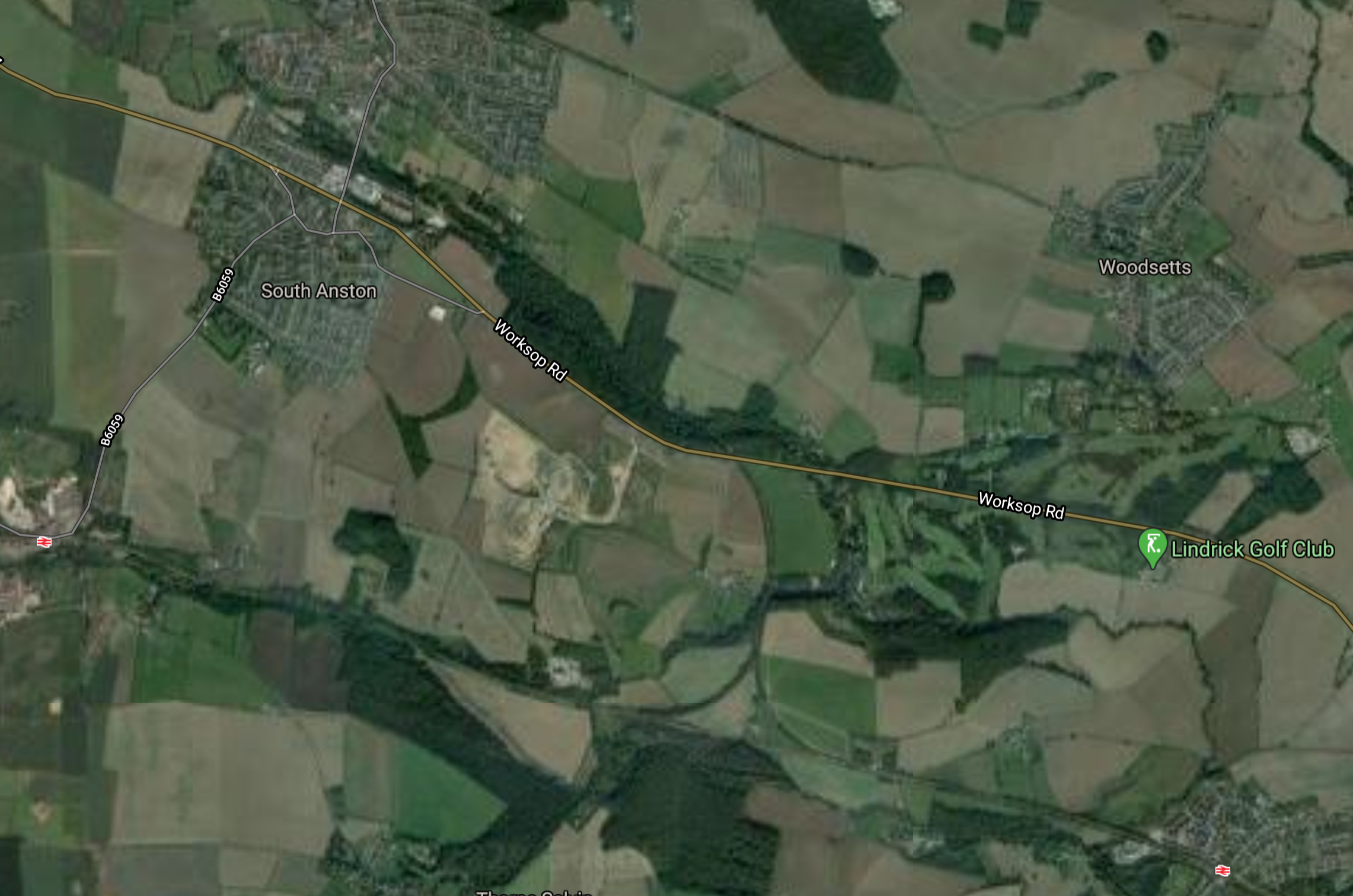
Note.
- Shireoaks station is in the East.
- Kiveton Park station is in the West.
- The SYJR starts at the triangular junction in the middle of the map.
- Lindrick Golf Club, where GB & NI, won the Ryder Cup in 1957 is shown by a green arrow to the North of Shireoaks station.
- The original passenger service on the SYJR, which closed in the 1920s, appears to have terminated at Shireoaks station.
The line immediately turns West and then appears to run between the villages of North and South Anston.
Anston Station
This Google Map shows the location of Anston station.
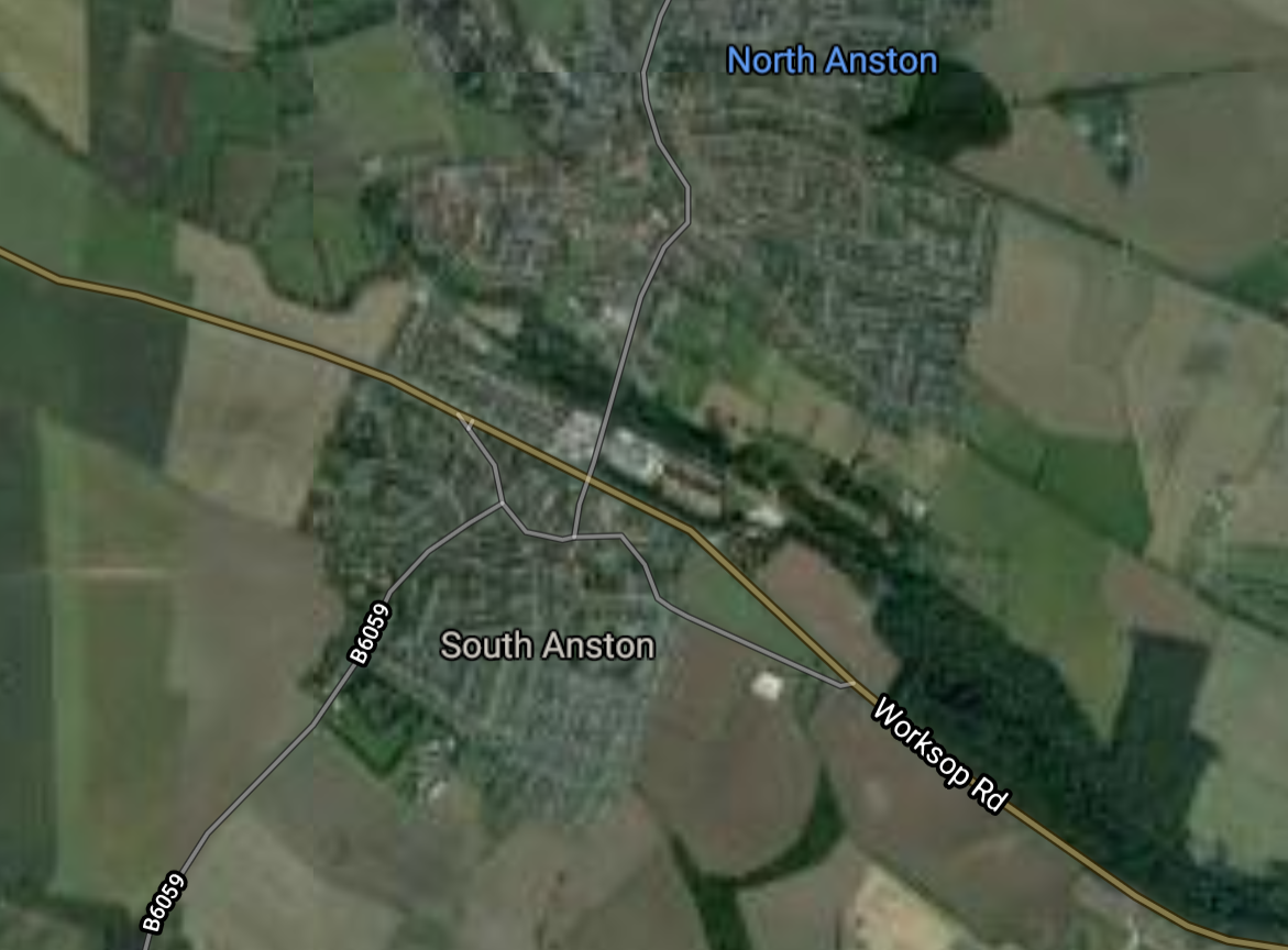
Note that the SYJR goes between the two villages and runs along the North side of the wood, that is to the North of Worksop Road.
Dinnington & Laughton Station
This Google Map shows the location of the former Dinnington & Laughton station.
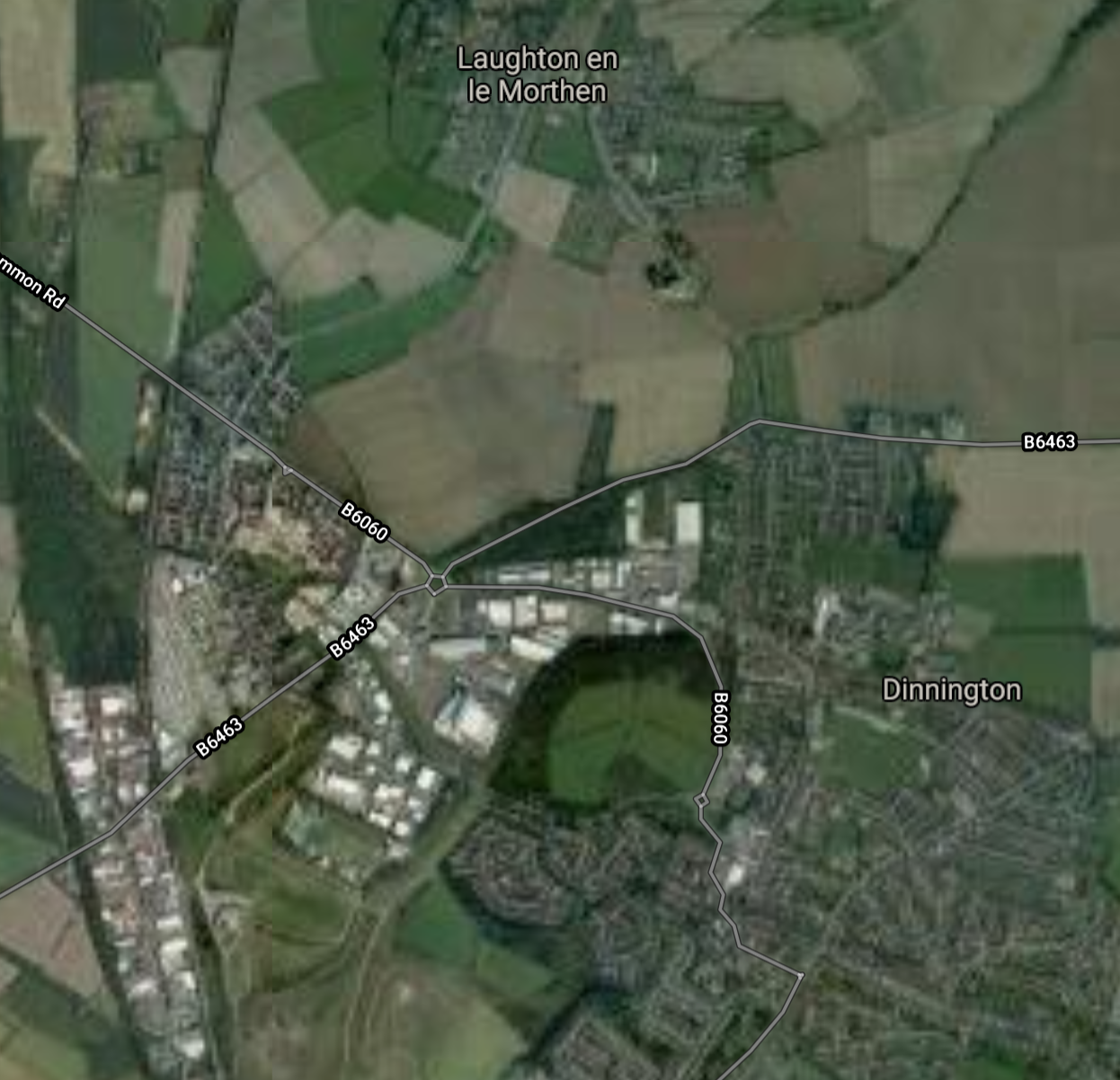
Note that the SYJR goes to the west side of both villages, so it would have been quite a walk to the train.
Maltby Station
This Google Map shows the location of the former Maltby station.
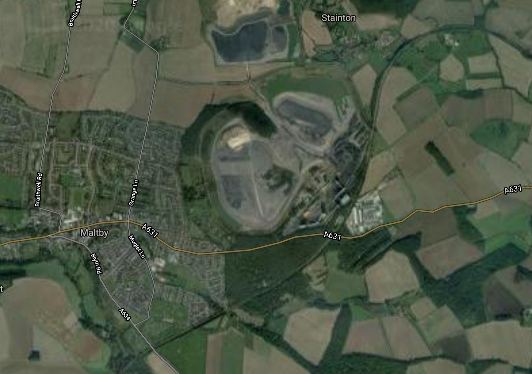
Note.
- The SYJR goes around the South side of the village.
- The remains of the massive Maltby Main Colliery, which closed several years ago.
I wonder if they fill the shafts of old mines like this. if they don’t and just cap them, they could be used by Gravitricity to store energy. In Explaining Gravitricity, I do a rough calculation of the energy storage with a practical thousand tonne weight. Maltby Main’s two shafts were 984 and 991 metres deep. They would store 2.68 and 2.70 MWh respectively.
It should be noted that Gravitricity are serious about 5.000 tonnes weights.
Tickhill & Wadworth Station
This Google Map shows the location of the former Tickhill & Wadworth station.
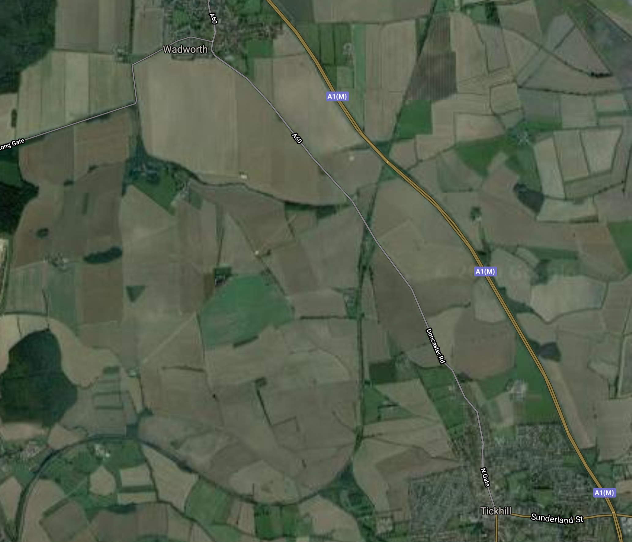
Note.
- Tickhill is in the South and Wadworth is in the North.
- Both villages are to the West of the A1 (M)
- The SYJR runs in a North-Easterly direction between the villages.
The station appears to have been, where the minor road and the railway cross.
Doncaster iPort
The SYJR then passes through Doncaster iPort.

Note.
- The iPort seems to be doing a lot of work for Amazon.
- The motorway junction is Junction 3 on the M18.
- The SYJR runs North-South on the Western side of the centre block of warehouses.
This is Wikipedia’s introductory description of the iPort.
Doncaster iPort or Doncaster Inland Port is an intermodal rail terminal; a Strategic Rail Freight Interchange, under construction in Rossington, Doncaster at junction 3 of the M18 motorway in England. It is to be connected to the rail network via the line of the former South Yorkshire Joint Railway, and from an extension of the former Rossington Colliery branch from the East Coast Main Line.
The development includes a 171-hectare (420-acre) intermodal rail terminal to be built on green belt land, of which over 50 hectares (120 acres) was to be developed into warehousing, making it the largest rail terminal in Yorkshire; the development also included over 150 hectares (370 acres) of countryside, the majority of which was to remain in agricultural use, with other parts used for landscaping, and habitat creation as part of environment mitigation measures.
It ;looks like the SYJR will be integrated with the warehouses, so goods can be handled by rail.
Onward To Doncaster
After the iPort, the trains can take a variety of routes, some of which go through Doncaster station.
I have some thoughts on the South Yorkshire Joint Railway (SYJR).
Should The Line Be Electrified?
This is always a tricky one, but as there could be a string of freight trains running between Doncaster iPort and Felixstowe, something should be done to cut the carbon emissions and pollution of large diesel locomotives.
Obviously, one way to sort out Felixstowe’s problem, would be to fill in the gaps of East Anglian electrification and to electrify the Great Northern and Great Eastern Joint Line between Peterborough and Doncaster via Lincoln. But I suspect Lincolnshire might object to up to fifteen freight trains per hour rushing through. Even, if they were electric!
I am coming round to the believe that Steamology Motion may have a technology, that could haul a freight train for a couple of hours.
These proposed locomotives, which are fuelled by hydrogen and oxygen, will have an electric transmission and could benefit from sections of electrification, which could power the locomotives directly.
So sections of electrification along the route, might enable the freight trains to go between Felixstowe and Doncaster iPort without using diesel.
It should be said, that Steamology Motion is the only technology, that I’ve seen, that has a chance of converting a 3-4 MW diesel locomotive to zero carbon emissions.
Many think it is so far-fetched, that they’ll never make it work!
Electrification of the line would also enable the service between Doncaster and Worksop to be run by Class 399 tram-trains, which are pencilled in to be used to the nearby Doncaster Sheffield Airport.
What Rolling Stock Should Be Used?
As I said in the previous section, I feel that Class 399 tram-trains would be ideal, if the line were to be electrified.
Also, if the line between Shireoaks and Kiveton Park stations were to be electrified to Sheffield, this would connect the South Yorkshire Joint Line to Sheffield’s Supertram network.
Surely, one compatible tram-train type across South Yorkshire, would speed up development of a quality public transport system.
A service could also be run using Vivarail’s Pop-up Metro concept, with fast charging at one or two, of any number of the stations.
Conclusion
This seems to be a worthwhile scheme, but I would like to see more thought on electrification of the important routes from Felixstowe and a unified and very extensive tram-train network around Sheffield.
Beeching Reversal – Upper Wensleydale Railway
This is one of the Beeching Reversal projects that the Government and Network Rail are proposing to reverse some of the Beeching cuts.
This map from the Upper Wensleydale Railway web site, shows the location of the proposed reinstated railway.
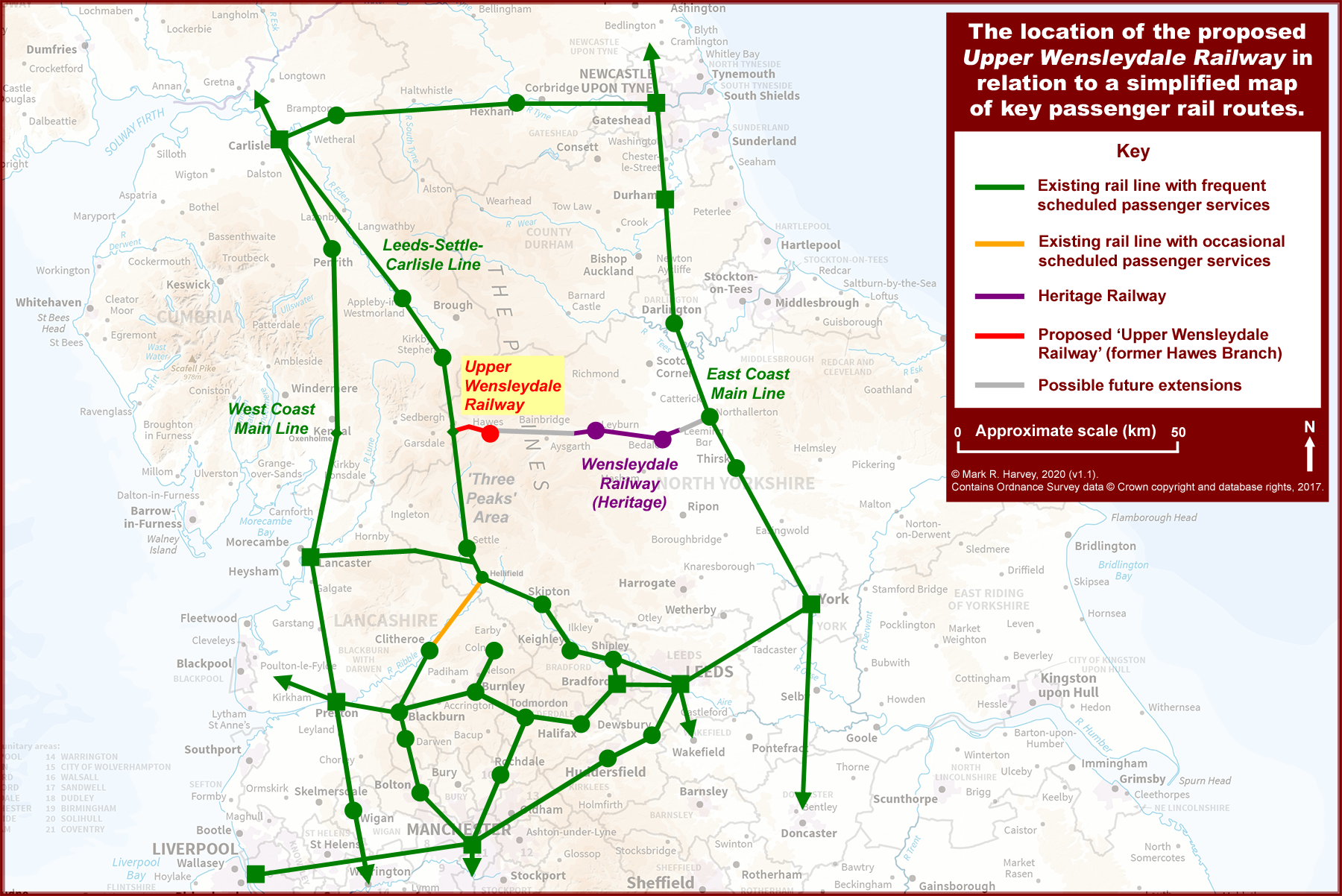
This is the vision of how the railway will be used, taken from the web site.
It is hoped that a reinstated junction with the existing Leeds – Settle – Carlisle railway line at Garsdale will allow ‘through’ trains to run from Hawes via Garsdale Junction, past the Yorkshire Three Peaks to Settle, then onwards through Hellifield and Clitheroe into Lancashire for Preston and Greater Manchester.
We are also hoping that some Manchester – Blackburn – Clitheroe trains can be extended to Garsdale and Hawes thereby linking Lancashire to an enhanced service through Settle to the Yorkshire Peaks and Dales.
Connections with other trains could be made at Hellifield (for West Yorkshire & Lancaster) and at Garsdale (for Carlisle, Scotland & the North East of England).
This Google map shows the current state of the railways at Garsdale.
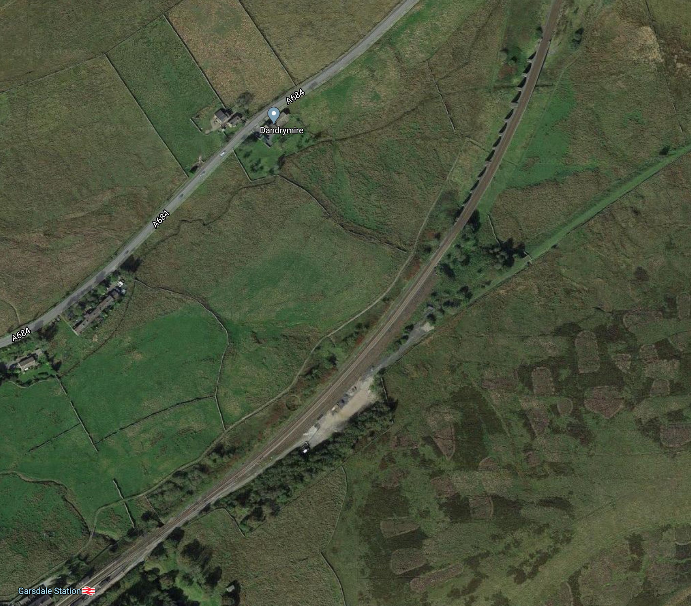
Note.
- Garsdale station in the South-West corner of the map.
- The Settle and Carlisle Line curving away to the North over the Dandry Mire Viaduct.
- The trackbed of the former branch to Hawes stands out as a green scar.
I have followed the route of the railway to Hawes in my helicopter and it doesn’t appear to be a very challenging project to reinstate.
- Although the comprehensive Routes and Structures page on the Upper Wensleydale Railway, indicates there is a lot to do.
- It is about six miles long.
- It is single track with a passing loop at Hawes.
This Google Map shows the town of Hawes,
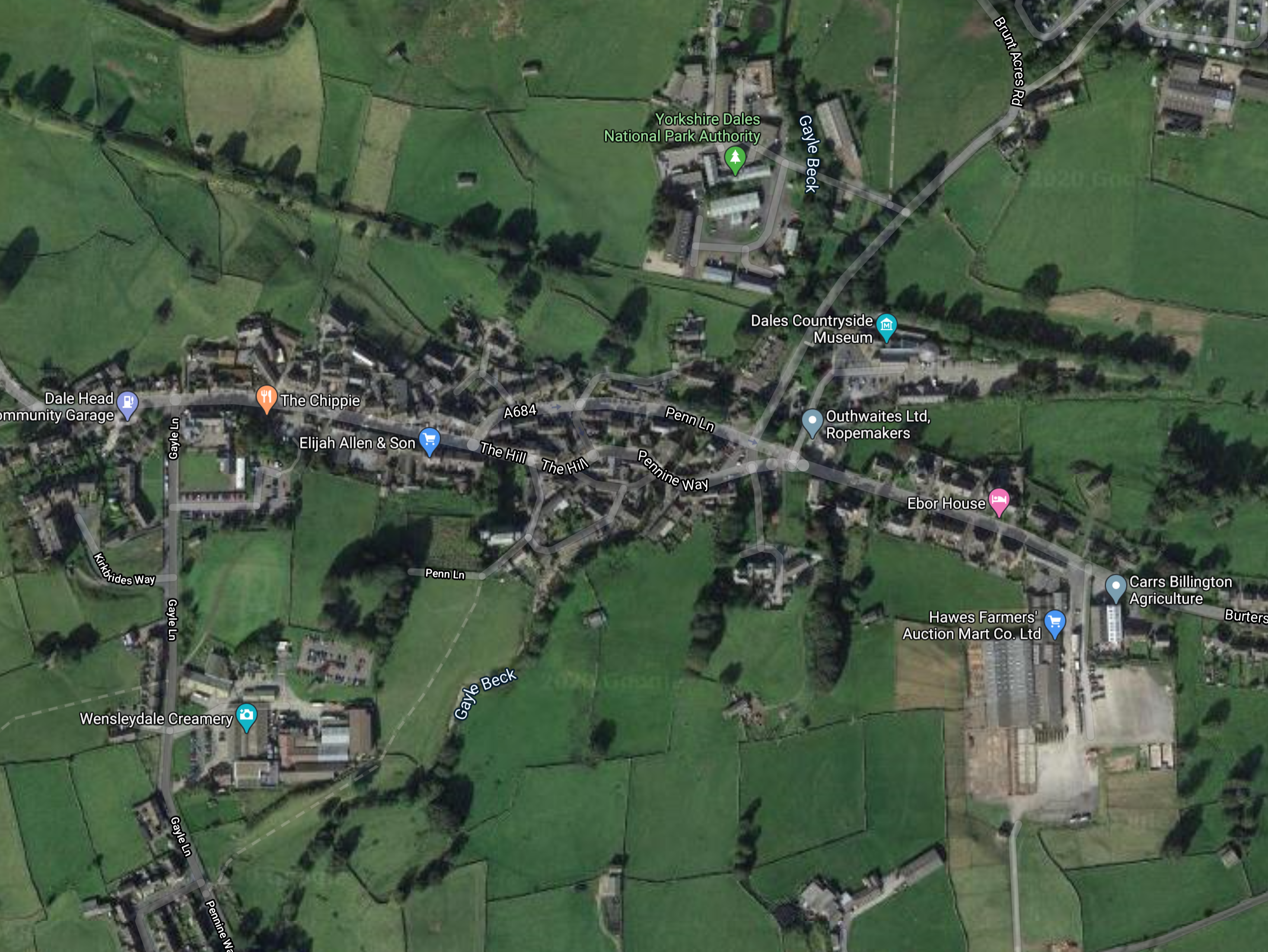
It certainly looks the sort of place, where Wallace and Gromit might rent a cottage for a week and use as a base to explore the countryside.
- There’s a Wensleydale Creamery.
- There’s a traditional ropemaker called Outhwaite, dating from 1905, who have the web site; www.ropemakers.com.
- The headquarters of the Yorkshire Dales National Park Authority are located in the North of the town and shown by a green arrow.
Next to the Park Authority is a blue arrow marking the Dales Countryside Museum, which incorporates the original Hawes railway station.
Services To Hawes
Looking at the data from Real Time Trains, it looks like trains on the Settle and Carlisle average about fifty mph on that line, which is generally double-track with an operating speed of sixty mph.
- I would estimate that a modern diesel or hydrogen-powered train could do the return trip between Garsdale and Hawes station in around thirty minutes.
- This time would probably mean that the Hawes Branch could be worked with only one train operational on the branch.
- It would also fit in well with the service plans for the Upper Wensleydale Railway.
I am fairly certain that an hourly service could be run between Hawes and Hellifield stations, which could be extended as far South as the operator wanted.
Military Traffic To Redmire
In the Wikipedia entry for Redmire village, this is said.
Redmire is the terminus of the Wensleydale Railway. The Ministry of Defence uses trains to transport armoured vehicles from bases in the south to the Catterick military area using Redmire railway station as its terminus.
It looks like there must be a quality railway between Redmire station and the East Coast Main Line at Northallerton.
This Google Map shows the site of Redmire station.
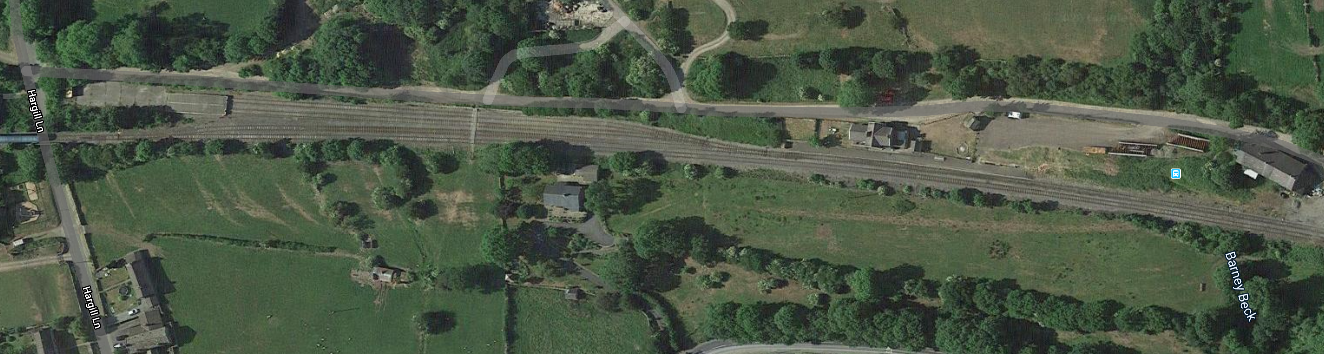
Note.
- At the left hand side of the map, there look to be loading ramps for the military vehicles, at the end of two sidings.
- The building on the North side of the tracks appears to be the old Redmire station buildings.
- The blue dot to the right, is a Google Maps pointer for the station
If you type Redmire into Google Maps, it’s easy to find..
This Google Map shows the rail lines at Northallerton.
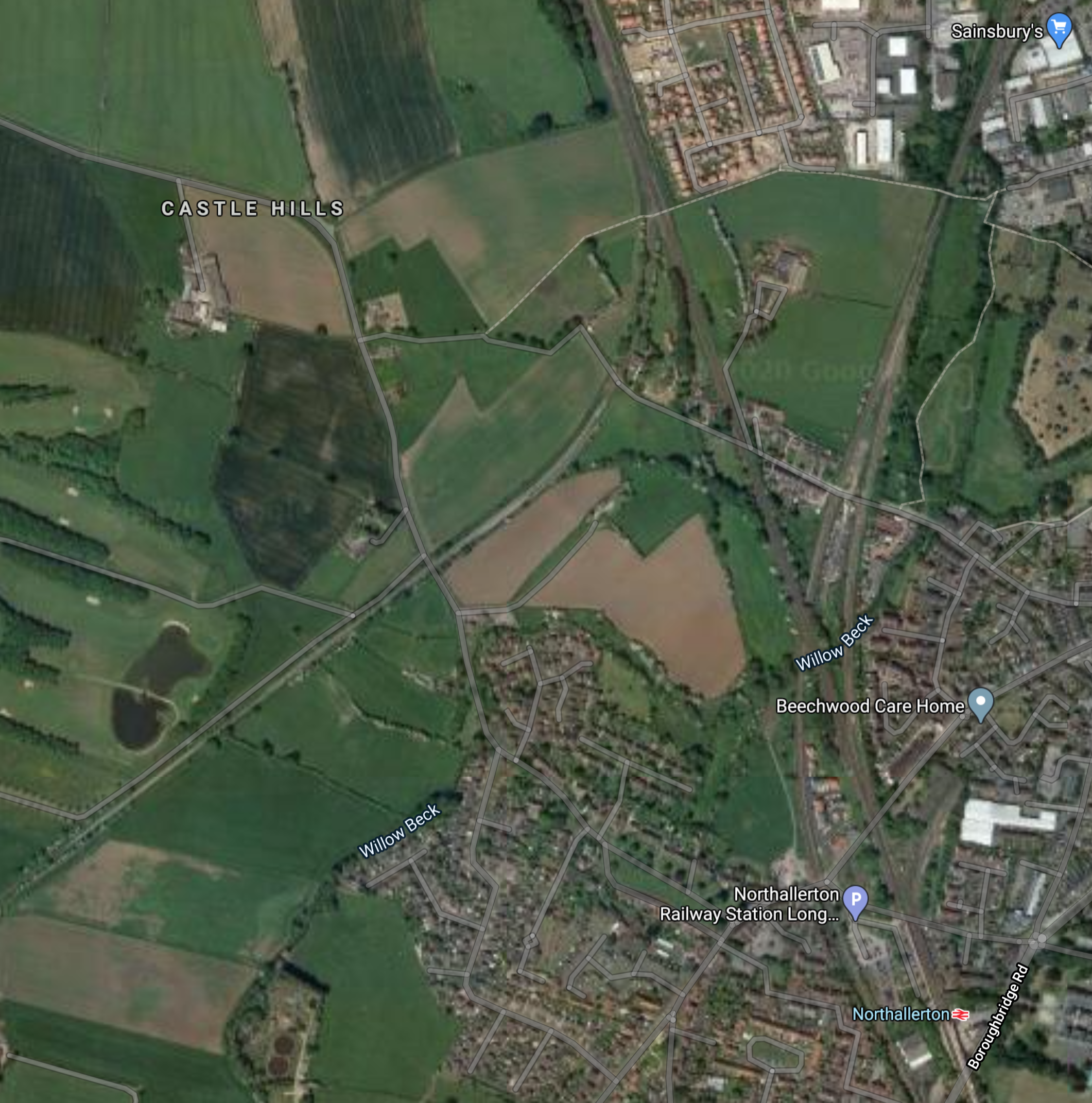
Note.
Northallerton station in the South-East corner of the map.
The East Coast Main Line runs about West-by-North from the station towards Darlington and Scotland.
The line to Middlesbrough branches off in a North-Easterly direction.
The Wensleydale Railway comes in from the West and joins the East Coast Main Line going North.
It also appears there used to be a tight chord that allowed trains to go between the Wensleydale Railway and the South.
It looks like the Army would like that chord for their vehicle trains.
This enlarged Google Map, shows the site of the chord.
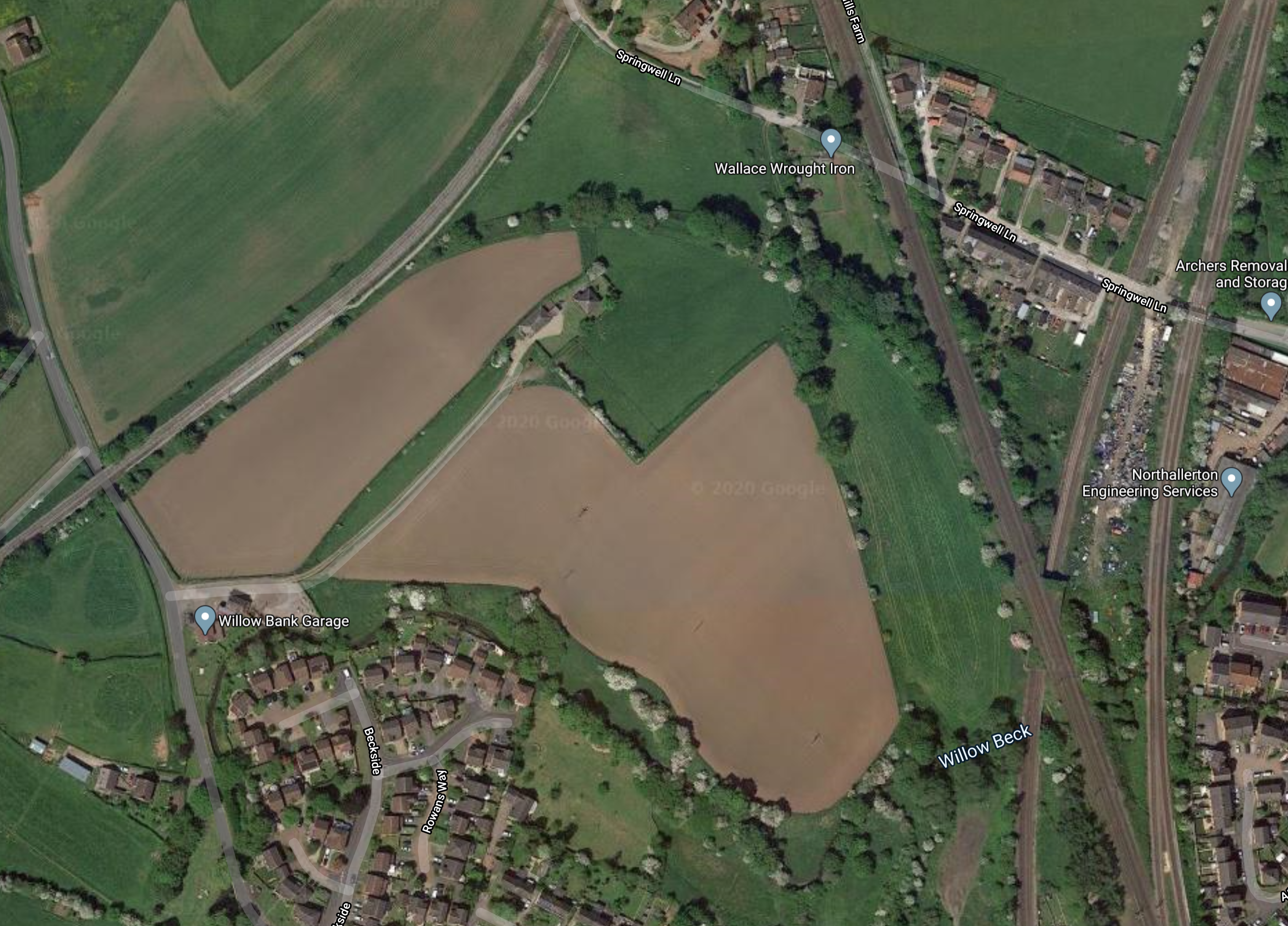
It looks to me, that it was once a chord, but now it’s a substantial wood.
A Bigger Plan
In the Wikipedia entry for the Wensleydale Railway, there is a section, which is entitled Upper Wensleydale Railway, where this is said.
In late 2019/early 2020, a separate company was formed to campaign to reinstate the line between Hawes and Garsdale. The groups’ objective is to have a timetabled year-round service run by a train operating company, rather than a heritage service. This scheme was shortlisted for funding in the second round of the government’s Reverse Beeching Fund, in June 2020.
These are my thoughts on various topics.
The Eastern Terminal
There are three possible Eastern terminals.
- Northallerton
- Middlesbrough – There is no connection to the Wensleydale Railway.
- Darlington – Would probably mean slow trains on the East Coast Main Line.
I think we’re left with Northallerton and the tight connection, which requires the chord to be reinstated.
But, it does say in the Wikipedia entry for Northallerton station, that the station is the terminus for the proposed extended Wensleydale Railway.
This Google Map shows the Northern end of Northallerton station.
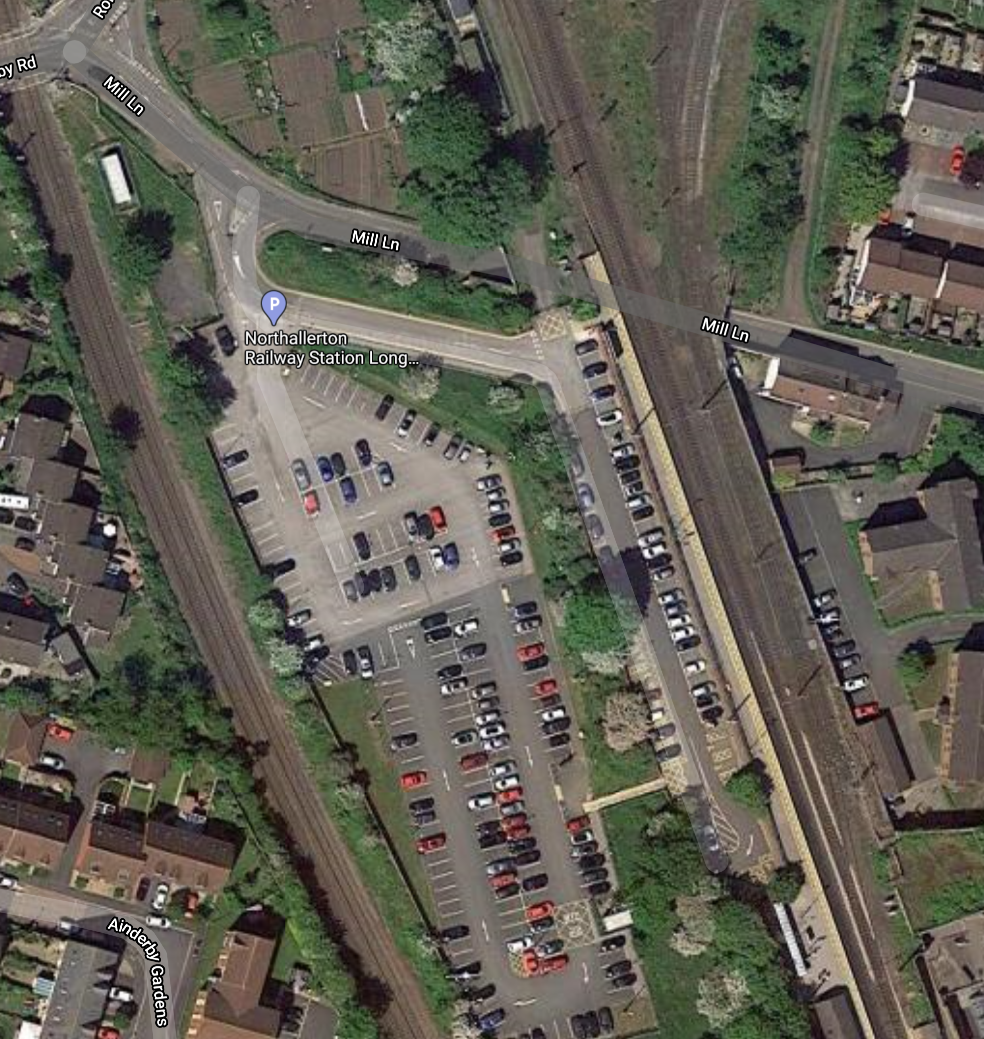
Would it be possible to sneak a line down the Western side of the East Coast Main Line and into a new bay platform at the station?
It would certainly allow trains from the Wensleydale Railway to terminate at Northallerton station.
The Western Terminal
As I said earlier, it’s the operator’s choice.
Personally, I would choose Blackburn station.
- It’s about fifty miles from Gardale station.
- There is a train depot at Blackburn.
- Blackburn station is in the Town Centre.
- Blackburn station has good rail connections to Blackpool, Liverpool, Leeds, Manchester and Preston.
Prior to COVID-19, I regularly stayed in the convenient Premier Inn next to the station.
Rolling Stock
The trains will have to be self-powered, as I don’t think the budget will run to electrification and much of the track-bed is owned by a heritage railway.
So that must mean the trains must be self-powered, which will mean either diesel, electric or hydrogen.
- I think diesel can be ruled out, except as a stop-gap, we are going carbon-neutral on the railways by 2040.
- Blackburn and Northallerton stations are too far for battery power.
So that means it must be hydrogen power.
But as, it appears that Teesside is going for hydrogen, as I wrote about in Fuelling The Change On Teesside Rails, that should be a convenient fuel.
The route might be a candidate for Vivarail’s Pop-up Metro concept, with fast charging at one or two, of any number of the stations.
Conclusion
I like this scheme, as it sorts a lot of problems.
I also think that there’s a fair chance, it will get the nod.
The local MP is the Chancellor of the Exchequer; Rishi Sunak and this could be a case of he who pays the piper, calls the tune!
