The Kerch Bridge Before The Attack Of November 2026
This Google Map shows the Kerch or Crimea Bridge before the attack.
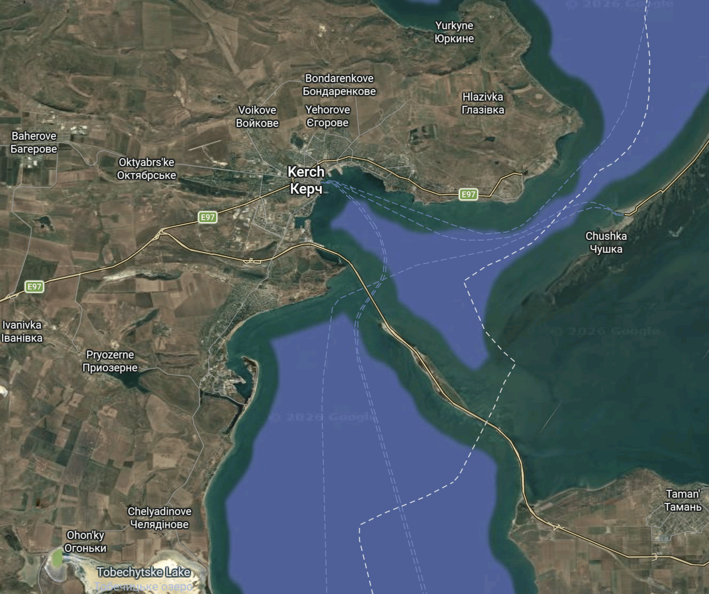
Note.
- The Western land is still Ukraine to every sane person.
- The city of Kerch is indicated on a bay.
- The Eastern land is Russia.
- The Taman Peninsular is in the South-East corner of the map.
- The Kerch Bridge connects Kerch to the Taman Peninsular.
- The bridge is 27 km. long.
- The Sea of Azov is North-East of the bridge.
- The Black Sea is South-West of the bridge.
- The dotted white lines are sea routes.
- There appear to be two main sea routes through the bridge.
It was the Northern route that seems to have been attacked.
This second Google Map shows the Kerch Bridge before the attack.
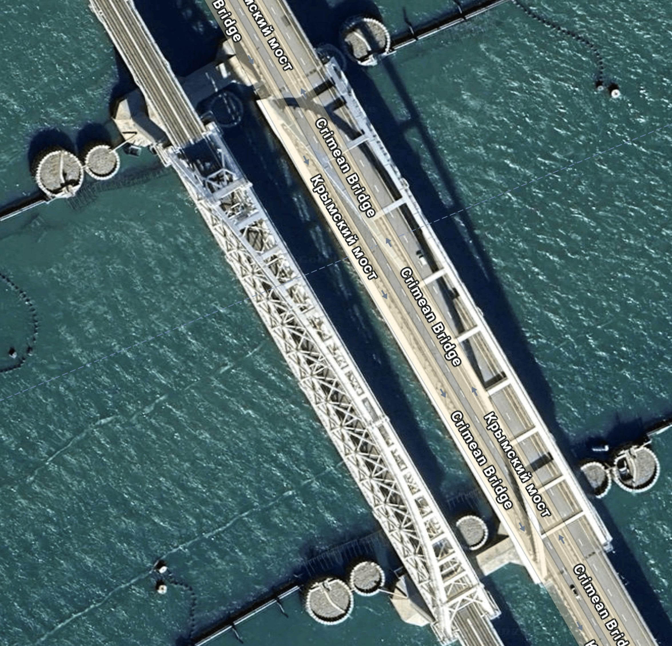
Note.
- There is pair of steel arch bridges.
- There is a double-track railway on the Western bridge.
- There is a two-lane double carriageway road on the Eastern bridge.
I believe that this was the bridge that was attacked by theUkrainians.
This third Google Map shows a wider view of the Kerch Bridge before the attack, with some ships about to cross under the bridge.
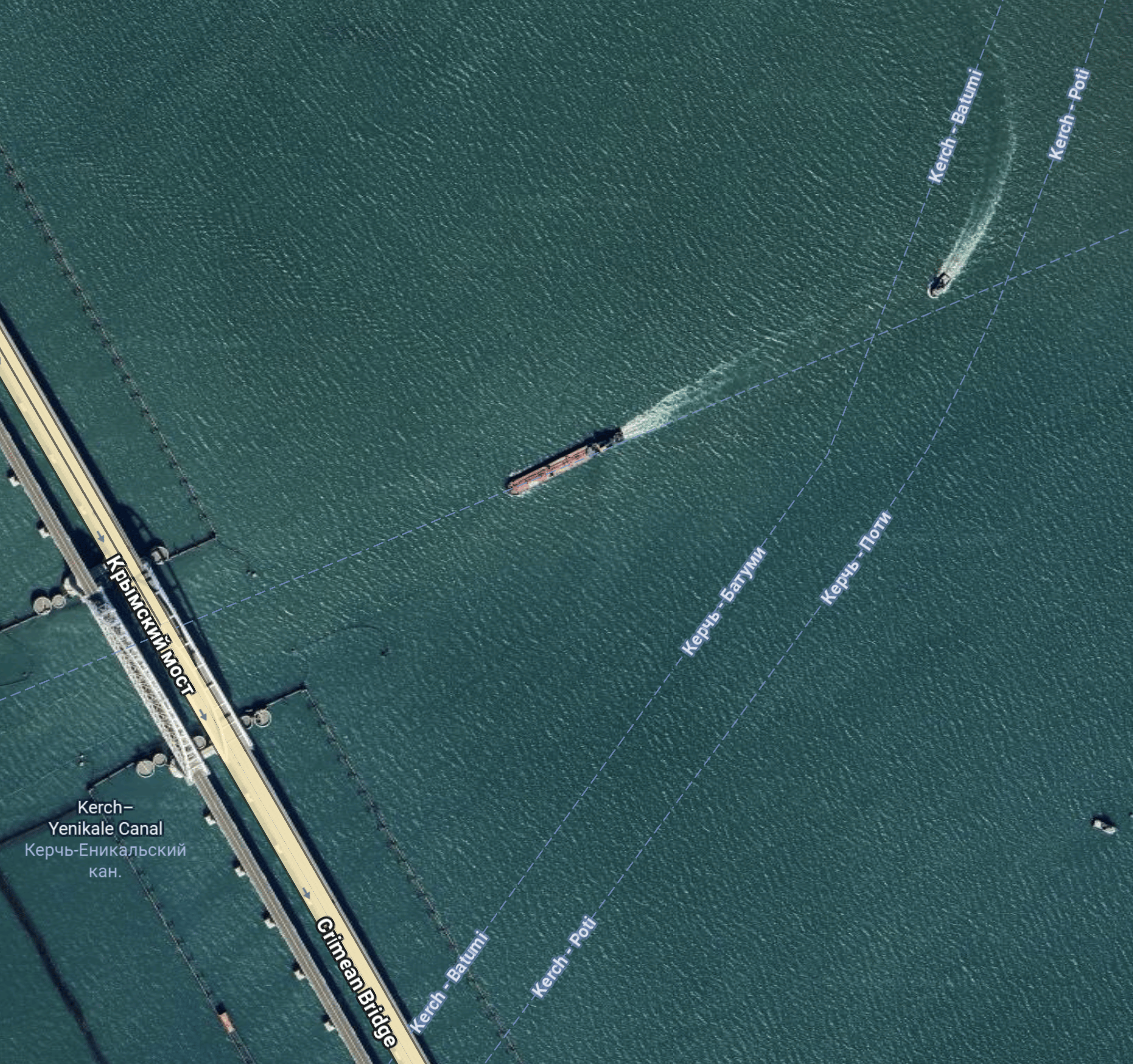
Note.
- The Northerly crossing appears at right-angles to the bridge.
- A ship appears to be going straight through.
- Another seems to be following behind.
- There appears to be another oblique crossing to the South of the steel arch bridges.
From the pictures of the damage, it appears the Ukrainians scored a direct hit.
Slava Ukraini
November 17, 2026 Posted by James | Transport/Travel, World | Black Sea, Bridges, Kerch Bridge, Russia, Russian Attack On Ukraine, Sea Of Azov, Ships, Ukraine | Leave a comment
About This Blog
What this blog will eventually be about I do not know.
But it will be about how I’m coping with the loss of my wife and son to cancer in recent years and how I manage with being a coeliac and recovering from a stroke. It will be about travel, sport, engineering, food, art, computers, large projects and London, that are some of the passions that fill my life.
And hopefully, it will get rid of the lonely times, from which I still suffer.
Why Anonymous? That’s how you feel at times.
Charities
Useful Links
Top Posts
- A List Of Gluten-Free Recipes
- I Have Uncomplicated Pancolonic Diverticular Disease And Coeliac Disease. Why Do I Feel Better, If I Eat A Whole Punnet Of Strawberries Every Afternoon?
- Where Is The Number 10 Bus?
- The West Midland's Transport Map
- Changing Trains At Carmarthen Station
- A Walk Between Kennington And Oval Tube Stations
- Where Should You Travel On An Elizabeth Line Train?
- About This Blog
- Why Did I Get The Samsung QLED Television With The Faulty Screen?
- Walking Routes Around London Bridge Station
WordPress Admin
Email Subscription
Join 1,825 other subscribers
Archives
Categories
Tags
2G Energy 3D Concrete Printing 3D Printing 3Squared Ltd 4G 4Silence 5 MW/20 MWh CRYOBattery 5G 6 x 6 HILOAD 8minute Solar Energy 11-Plus 22 Ropemaker Street 30 GWh CRYOBattery 73 Group 92 Clubs 92CCBB 101 Moorgate 150 222 420 777 1957-58 Flu Pandemic 1972 Stock 1992 Stock 2015 Three Queens Gathering 2017 Extension Projects 2022 2023 Turkey-Syria Earthquake 2025 Runcorn And Helsby By-Election 2028 Four Queens Gathering @sohoplace Theatre A & E A.P. Moller – Maersk A1(M) Motorway A4 Pacific Steam Locomotive A 10 Thunderbolt II A14 A14 Parkway Station A27 Worthing Tunnel A30 A57 A 66 ABB Abbey Line Abbey Mills Pumping Station Abbey Wood Station Abebe Bikila Abellio Aberarder Wind Farm Abercynon Station Aberdare Station Aberdeen Aberdeen Airport Aberdeen And Iceland Ferry Aberdeen And Inverness Line Aberdeen And Penzance Route Aberdeen Bay Wind Farm Aberdeen Crossrail Aberdeen Station Aberdeen University Aberfan Disaster Abergavenny Abergavenny Station Aberystwyth Aberystwyth Station Able Seaton Port Abortion ABP Abu Dhabi Abuse Accelera By Cummins Acceleron AccelorMittal Access To Toton Accident Accountants Acer Iconia Acetylene Acorn Carbon Capture And Storage Project ActionFraud Acton-Northolt Line Acton Central Station Acton Dive-Under Acton Main Line Station Acton North Station Acupuncture A Day Trip From London To Manchester And Leeds A Day Trip To Ebbw Vale Town Station Addenbrooke's Hospital Additive Manufacturing Adessia ADHD Administration Adnams Adnams Ghost Ship 0.5% Beer ADO 15 Mini Adoption Adrian Shooter Advanced Air Mobility Advanced Ionics Advanced Manufacturing Research Centre Advanced Propulsion Centre Advertising Adwick Station AECOM AEG Aeolian Islands Aerodynamics Aerosol Aerospace Technology Institute Aerus AfD AffeX Affric/Beauly Hydro-Electric Scheme Afghanistan Africa Afternoon Tea After Overground Aga Khan Age-Related Macular Degeneration Aggregates Agile Energy Agriculture Agrivoltaics Ahmedabad Ahmedabad Plane Crash AIDS Aikido Technologies Ainsdale Aintree Race Course Air Air-Conditioning Air Accidents Airbus Airbus A 318 Airbus A 320 Airbus A 320 ceo Airbus A 320 neo Airbus A 321 Airbus A 321 XLR Airbus A 330 ceo Airbus A 340 Airbus A350 Airbus A 350 Airbus A350 XWB Airbus A380 Airbus A 390 Airbus Beluga Airbus Beluga XL Aircat Vessels Aircraft Aircraft Carrier Air France Air India Airlines Air Liquide Air New Zealand Air Passenger Duty Airports Air Products Airship Air Source Heat Pump Air Traffic Control Aker Aker BP Aker Solutions Aker Subsea Collector Akiem Alan Ball Alaska Airlines Albania Albannach Island Alberta Albert Embankment Foreshore Albert Hall Alcohol Alcoholism Aldbrough Gas Storage Aldeburgh Branch Line Aldeburgh Station Alderley Edge Station Aldgate Bus Station Aldridge Station AlexanderDennis Alexandra Palace Alexandra Palace Station Alexei Navalny Alex Ferguson Alex Salmond Alf Ramsey Algae Algeria Alginate Industries Allergies All Hallows Staining Alliance Rail Allianz Alloa Station Allume Energy Alnmouth Station Aln Valley Railway Alnwick Alperton Station Alrewas Station Alstom Alstom Coradia Polyvalent Alstom Hydrogen Aventra Alstom Prima Locomotive Altalto Alternative Vote Alton Towers Altrincham Station Aluminium Alzheimer's Amalfi Coast Amazon Amazon Web Services Amber Rudd Amber Train Ambulance American Airlines American Clean Power Association American Football Americium Amersham Station AMETS Amilcar Amlwch Ammonia Ammonia-Powered Ships Ammonia-Powered Vehicles Amogy Amp Energy Amprion Offshore Amsterdam Amsterdam Metro AMTE Power Anaesthesia Analog Computer Andover Station Andrea Leadsom Andrew Forrest Andrew Marr Andy Burnham Andy Burnham's Conference Speech 2026 Andy Murray Andy Street Angela Merkel Angel Road Station Angel Station Angel Trains Anglesey Anglesey Airport Anglesey Central Railway Anglesey Mining Anglian Water Anglia Railways Anglia Water Angling Anglo American Anglo Belgian Corporation A Night In Bradford Animals Anne Frank Anniesland Station Anniversary Games Ansdell And Fairhaven Station Antarctica Antibes Antisemitism Antivirals Antonov-225 Antwerp Antwerp Station Aosta Aosta Station Aosta Valley Apathy Apollo 11 Apollo 13 Apollo Program Appeasement Apple Appledore Appliances Apprenticeship Apps April Fool Aqua Aerem Aquaculture AquaDuctus Aquarius Engines AquaVentus A Quick Visit To Tisbury Station Arch 42 Archaeology archit architec Architecture ARC Marine Arcola Energy Arctic Ardersier Ardlui Station aream Group Arenko Group Argentina Argonne Laboratory Arizona ARM Armoured Fighting Vehicle Army Arnos Grove Station Arora Group Arriva Arrival Arriva Rail North Arriva Trains UK Arron Banks Arsenal Art Artemis Artemis Intelligent Power Artemis Technologies Arthritis Artic Convoys Artificial Intelligence Artificial Reefs Arundel Chord Arup Arven Wind Farm Arwen Asa Coast Railway Asbestos ASCO Carbon Dioxide Ascot Racecourse Ascot Station ashby-de-la-Zouch Ashford Spurs Ashford Station Ashington Station Ashley Down Station Ashton Gate Stadium Ashton Gate Station Ashurst Station Asia Asian Flu 1957-58 Asian Renewable Energy Hub Askern Branch Askern Station ASLEF Aspall Aspen Offshore Wind Farm Aspidistra ASPIRE Ammonia Project Associated British Ports Asthma Aston Rowant Extension Aston Villa FC AstraZeneca Astrology Astronomy Aswan Dam Asymmetric Bi-Mode Train Atacama Desert At A Glance – Northern Powerhouse Rail Athens Athletics Atlantic Coast Line Atlantic Green Atlantic Ocean Atlantic Partnership For Advanced Nuclear Energy Atmonia Atmospheric Pressure Atom Bank ATR 72 Atrial Fibrillation Auckland Augsburg Augwind Energy AUKUS Aung San Suu Kyi Aura Aero Era Aura Power Aurizon Auschwitz Austerity Austin Australia Australia-Asia PowerLink Australian Electric Mining Freight Austria Automated Shuttle Train Automatic Splitting And Joining Of Trains Automatic Train Operation Automation Autonomous Shuttle Bus Avacon Avanti West Coast Aventra Aviation Aviva Aviva Arena AVK AVL RACETECH Avnos Avocet Line Avro Lancaster Avro Vulcan AW-Energy A Week North Of Seville Awel y Môr Winf Farm Axminster Station Aylesbury Line Aylesbury Station Aylesbury Vale Parkway Station Ayre Wind Farm Azelio Azerbaijan Azores Azteca Stadium Azuma Train B12 Deficiency B12 Injection B23 Stock B52 Baboons Bacon Factory Curve Bacton Gas Terminal Baden-Baden Badger Badminton Bad Vibrations Bad Weather BAe 125 BAe 146 BAe Systems Baguley Station Baked Beans Bakerloo Line Bakerloo Line Extension Bakerloop Bakerloop BL1 Bakersfield Bakewell Baking Balaena Structures BALDIES Balgray Station Balham Station Ballard Power Systems Ballet Balliemeanoch Pumped Hydro Balloch Station Balloons Balls Pond Road Ballylumford Power-to-X Ballylumford Power Station Ballymena Ballymena Electrolyser Balmacaan Estate Balmacaan Pumped Hydro Balmoral Offshore Balsall Heath Station Baltic-German PowerLink Baltic Power Offshore Wind Farm Baltic Sea Baltic States Bamboo Bamford Station Bananas Banbury Station Bangladesh Bangor Bangor Station Bangor University Bank Bank And Moorgate Moving Walkway Bank Holiday Banking Bank of England Banks Bank Station Bank Station Cannon Street Entrance Bank Station Upgrade Bank Station Walbrook Entrance Banksy Bannatyne Group Baptists Barack Obama Barbados Barbican Barbican Station Barcelona Barcelona Metro Barclays Barents Sea Barking Railfreight Terminal Barking Riverside Barking Riverside Station Barking Station Barley Barnes Barnes Bridge Barnes Bridge Station Barnes Station Barnes Wallis Barnet Barnetby Station Barnsley Barnsley Dearne Valley Station Barnsley Interchange Station Barnstaple Barnstaple Station Barog Station BaroMar Baron's Court Station Barra Airport Barrington Quarry Barristers Barrow-in-Furness Barrow-in-Furness Station Barrow Green Gas Barrow Green Hydrogen Barrow Hill Line Barry Station Barton Line Barts Hospital Basel Baseload Power Hub BASF Basingstoke Station Basset Hound Bassoe Technology Bath Bathgate Depot Bathgate Station Bathrooms Baths Bath Spa Bath Spa Station Bath University Bats Batteries Battersea Battersea Bridge Battersea Park Station Battersea Power Station Battersea Power Station Pier Battersea Power Station Station Battersea Underground Station Battery Battery-Electric Buses Battery-Electric Class 331 Train Battery-Electric Ferry Battery-Electric Locomotives Battery-Electric Ships Battery-Electric Trains Battery-Electric Trains On The Henley Branch Battery-Electric Tram Battery-Electric Trucks Battery-Electric Vehicles Battery/FLEX Train Battery Energy Storage Systems (BESS) Battery Optimisation Battery Recycling Battery Tender Battle Of Britain Battle Of Cable Street Bawdsey BayFloat Bay Of Fundy BayWa BayWa.re BBC BBC Tech Now BCRRE Beach Volleyball Beacon Rail Leasing Beaconsfield Station Bealings Station Beam Park Station Beards Bears Beatles Beauchief Station Beaulieu Park Station Beavers Bechtel Beckenham Junction Station Beckenham Road Tram Stop Bed-Blocking Bedford Bedford Cauldwell Park TMD Bedford Hospital Bedford Station Bedford St Johns Station Bedlington Station Bedlington Terrier Bedlinog Station Beds Bedwyn Station Beeching Beeching Reversal Beeching Reversal - Heritage Project Beech Offshore Wind Farm Beef Bee Network Beer Bees Beeston Castle And Tarporley Station Before Crossrail Before Crossrail 2 Before GOBlin Electrification Before Overground Begging BeHydro Bekestone Street Belarus Belfast Belfast City Airport Belfast Harbour Belfast Harbour Cruise Terminal Belfast International Airport Belfast Lanyon Place Station Belgium Bellingham Bellingham Station Bellrock Wind Farm Belmont Station Benecol Benedict O’Looney Benefits Benjamin Disraeli Benjamin Netanyahu Bentley Ben Wallace Bere Alston Station Berkeley Berkeley Nuclear Power Station Berkshire Berkswell Station Berlin Berlin Brandenburg Airport Berlin Hauptbahnhof Berlin S-Bahn Berlin U-Bahn Berlusconi Bermondsey Dive-Under Bermondsey Station Bernese Oberland Railway Berwick-on-Tweed Berwick-on-Tweed Station Berwick Bank Wind Farm Bescot Stadium Station bess Beta Technologies Alia Betfair Better Fuel Technology Betting Beulas Beverley Beverley Station Bexhill Bexleyheath Bexley Station Beyoncé BHELT BHE Renewables BHP BHS Bi-Mode Locomotive Bi-Mode Train Bialystok Biarritz Bibby Stockholm Bicester Bicester Chord Bicester Level Crossing bicester Village bicester Village Station Bicker Fen Bicker Fen 1 BESS Bicker Fen 2 BESS Bicycle Parking Bidston Station Big Belly Big Geordie Bigotry Bikini Bilbao Bilfinger Billbao Bill Clinton Bill Gates Bingo bio-CNG Bio-Coal bio-LNG Biodiesel Biodiversity Bioengineering Biofuel Biogas Biomass Biomethane Biomethane-Powered Buses Biomethane-Powered Locomotives Biopropane BIPVco Bird Migration Birds Birds And Wind Turbines Birmingham Birmingham Airport Birmingham And Nottingham High Speed Line Birmingham City Birmingham Curzon Street Station Birmingham Interchange Station Birmingham International Station Birmingham Moor Street Station Birmingham New Street Station Birmingham Snow Hill Station Birmingham University Birmingham University Station Birthdays Biscuits Bishop's Stortford Bishop's Stortford Station Bishop Auckland Station Bishopsgate Goodsyard Bitcoin Bittern Line Bjorn Lomborg Black-Body Thermometer Blackberry Black Body Radiation Blackburn Blackburn Depot Blackburn Station Blackfish Engineering. Blackfriars Bridge Blackfriars Bridge Foreshore Blackfriars Station Blackheath Station Blackhillock BESS Blackhorse Road Station Blackpool Blackpool Airport Blackpool Multiversity Blackpool North Station Blackpool South Station Blackpool Tramway BlackRock Black Sea Black Start Blackstone Group Blackwall Tunnel Blaenau Ffestiniog Station Blankenberge Station Blended Wing Body Bletchley Bletchley Station Bletchley Viaduct Blog Blogger Blogging Blood Blood Clots Blood Pressure Blood Test Bloomberg Building Bloom Energy Bluebell Railway Blue Eden Bluefield Solar Income Fund BlueFloat Energy Blue Gem Wind Blue Hydrogen Blue Peter Blue Planet II Bluewater Shopping Centre Blyth Blyth Bebside Station Blyth Data Centre BMW BMW Mini BNSF Bo'ness And Kinniel Railway BOAC Boarding School Boats Bobby Robson Bob Dylan Bobsleigh Boccard UK Bo Diddley Bodmin General Station Bodmin Parkway Station Body Shop Boehringer Ingelheim Boeing Boeing 717 Boeing 737 Boeing 737 MAX Boeing 747 Boeing 757 Boeing 767 Boeing 777 Boeing 787 Boeing B-52 Boer War Bognor Regis Bolton Bolton-on-Dearne Station Bolton Station Bolton Wanderers Bombardier Bombardier CRJ700 Bombardier Takeover Bomb Disposal Bombora Bond Street Station Bonneville Salt Flats BookAid Books Boom Overture Boots The Chemists Boralex Bordeaux Borderlands Borderlands Line Borders Railway Bordesley Chords Bord Gáis Energy Bordon Light Railway Boredom BorgWarner Boris Johnson Borkum Riffgrund 3 Bornholm Bornholm Energy Island Borough Of Barking And Dagenham Borough of Islington Bosch Boson Energy Boston Manor Station Boston Metal Boston Station Botley West Solar Farm Bottesford Station Bottled Guinness Boulby Mine Bounds Green Station Bourne End Station Bournemouth Bournemouth Station Bow Church Station Bowdun Wind Farm Bowes Park Station Bow Street Station Boxing BP BP Aberdeen Hydrogen Hub BP Teesside Hydrogen Hub Braathens Airlines Brabazon Bradford Bradford Electrolyser Bradford Forster Square Station Bradford Interchange Station Bradford New Through Station Bradwell Nuclear Power Station Brain Brain Injuries Braintree Branch Line Braintree Freeport station Braking Bramble Energy Bramford substation Bramley Line Bramley Station Brandenburg Brandon Station Brands Hatch Brassavola Combined Cycle Power Plant Bratislava Braunschweig Brazil Bread Breadalbane Hydro-Electric Scheme Breakfast Breast Cancer Breast Implant Breckland Line bremen Bremen Airport Bremerhaven Bremervörde Station Brent Cross Brent Cross Shopping Centre Brent Cross West Station Brentford Brentford Branch Line Brentford FC Brentford Stadium Brentford Station Brentwood Station Brescia Brescia–Edolo railway BrestPort Brexit Bribery Bricket Wood Station Brickwork Bridgepoint Group Bridges Bridlington Bridlington Station Brigg Energy Park Brigg Power Station Brightline Brighton Brighton & Hove Council Brighton Main Line Brighton Station Brighton University Brigitte Bardot Brimsdown Station Bristol Bristol - Exeter Line Bristol Airport Bristol And Oxford Service Bristol Brabazon Bristol Brabazon Station Bristol Channel Bristol City Bristol Parkway Station Bristol Rovers Bristol Temple Meads Station Britannia Bridge Britannia Refined Metals British Airways British Army British Columbia British Gas British Gas Research British Geological Survey British Land British Leyland british Library British Lithium British Motor Corporation British Museum British Rail British Rail BEMU british Railways British Steel Britishvolt BritNed Interconnector Brittany Britten-Norman Islander Brixton Station Brixton Tunnel Broadband Broadgate Broadshore Wind Farm Broadstairs Broadstairs Station broad Street Station Brockley Lane Station Brockley Station Broken Humerus Bromine Bromley Bromley-by-Bow Station Bromley North Line Bromley South Station Brompton Bicycle Bromsgrove Station Brondesbury Station Bronte Sisters Brookfield Brough Station Broughton Station Brown Coal Brownfield Site Brownsville Browser Broxbourne Station Bruce Grove Station Bruges Brunel Brunel Bridge Brunel Museum Brunstane Station Brussels Brussels Sprouts BT BT Research BT Sport BT Vision Bubbles Buccleuch Group Buchan Wind Farm Buckingham Palace Buckminster Fuller Budapest Budesonide Budget 2020 Budget 2021 Budget 2025 Budget 2026 Budweiser Bugs Building Bulgaria Bullying Bunhill 2 Energy Centre Bunhill Energy Centre Bunkering Burberry Bureau of Ocean Energy Management (BOEM) Bure Valley Railway Burma Burnham Station Burnley Burnley Barracks Station Burnley Central Station burnley Manchester Road Station Burnt Oak Station Burscough Bridge Station Burscough Curves Burscough Junction Station Burst Aorta Burton Station Bury Bolton Street Station Bury St. Edmunds bus Busby Railway Buses Bus Garages Bush Hill Park Station Bushveld Minerals Business Business Aircraft Busometer Bus Routes And Crossrail Bus Stop Butterflies Buxtehude-Cuxhaven Line Buxtehude Station Buxton Buxton Line Buxton Station BuzzBallz BW Ideol BWXT BYD BYD Battery-Electric Buses Byron Bay Railroad C-17 C-Capture C-Dart c2c C3R Project Cabinet Office Cable-Car Cable Protection Cables Cable Theft Cadent Cadiz Cadoxton Station Caerphilly Station Caerphilly Tunnel CAF CAF Battery-Electric Trains Cafe CAF Tri-Mode Train Cairo Monorail Cakes Calais Calculations Calderdale Council Calderdale Wind Farm Calder Hall Nuclear Power Station Calder Valley Line Caledonian Road & Barnsbury Station Caledonian Sleeper Caledonia Wind Farm Calibrant Energy California Call-Centres Calvert HS2 Station Camberwell Station Cambodia Cambo Oilfield Cambourne Station Cambrian Heritage Railways Cambridge Cambridge Autonomous Metro Cambridge Biomedical Campus Cambridge Busway Cambridge Metro Cambridge North Station Cambridgeshire Autonomous Metro Cambridge South Station Cambridge Station Cambridge Station Square Cambridge University Cambridge Vacuum Engineering Camden High Line Camden Market Camden Road Station Camden Town Station Camden Town Station Upgrade Camels Camel Trail Cameron Bridge Station Cammell Laird Camoflage Camp Hill Line CampionWind Wind Farm Canada Canada Water Station Canadian National Canadian Pacific Canals Canal Tunnels Canary Islands Canary Wharf Canary Wharf Station Cancer Cancer Research UK Candida Auris Canfranc Station Cannabis Canning Town Canning Town Station Cannon Street Station Canoe Slalom Canonbury Curve Canonbury Station Capacity Crunch At Chester Capacity Factor Cap And Floor cape Capital Punishment Cara Delevingne Carbon-Fibre Carbon Black Carbon Capture Carbon Capture And Storage Carbon Capture And Use Carbon Capture Use And Storage CarbonCure Technologies Carbon Dioxide carbon Offset Carbuncle Cup Cardboard Cardiac Pacemaker Cardiff Cardiff Airport Cardiff Bay Station Cardiff Central Station Cardiff City Cardiff Crossrail Cardiff Parkway Station Cardiff Queen Street Station Cardiff Valley Lines Card Index Cardiology Care Home CargoBeamer Cargo Bikes Cargo Drones Cargo Sous Terrain Carillion Failure Carlisle Carlisle Station Carlos Alcaraz Carlos Queiroz Carlton Power Carluccio's Carmarthen Station Carmarthen–Aberystwyth Line Carnforth Station Carnot Engines Caron Neutral Energy Carrington LDES Carrington Park Freight Terminal Carrington Power Station Carr Mill Station Cars Carshalton Beeches Station Cartoons Casablanca Cashless Buses Cashless Payments Cash Machine Cassiobridge Station Castle Castle Bromwich Station Castlefield Corridor Castner-Kellner Process Castrol ON Catalina Express Catalina Island Catalyst Capital Cataract Cataracts Caterham Station Caterpillar Catford Bridge Station Catford Station Cathays Station Cathedral Cats Caustic Soda Cavendish Square Development CCGT CCTV CDPQ Cedar Offshore Wind Farm Celebrations Celebrity Celia Lager Cellarhead BESS Celtic Cluster Celtic Sea Cement Cemex Cenos Wind Farm Censorship Census Centovalli Railway Central Communications Port Central Japan Railway Central Line Centre for London June 2016 Proposals Centre Point Centrica Centrica Battery Optimisation Centrica Business Solutions Centrica Gas Purchase Agreement Centrica Small Energy Projects Ceramics Cereals Ceres Power Holdings CERN Certification Cerulean Winds Cessna 172 Cessna 340 Cessna Caravan CFCs Chad Varah Chadwell Heath Station Chalfont & Latimer Station Chalk Farm Chalkwell Station Championship 2014-2015 Champions League Chancellor Of The Exchequer Channel 4 Channel Islands Channel Islands Rail Tunnel Channel Tunnel Charco Neurotech Charfield Station Charging Battery Ships Charging Battery Trains Charging Electric Vehicles Charing Cross Station Charity Charles de Gaulle Airport Charles Rolls Charlton Chart Industries Chase Line Chatham Main Line Chatham Station Chathill Station Chatsworth House Cheese Cheesecake Energy Chelmsford Chelmsford Station Chelsea Chelsea Harbour Pier Cheltenham Chemical Catalyst Chemical Engineering Chemical Industry Chemical Weapons Chemistry Chemnitz Chemnitz University Cheriton Station Chernobyl Chertsey Branch Line Chesham Station Cheshire Cheshire Green Hydrogen Cheshunt Station Chester Chester And Liverpool Via Runcorn Train Service Chesterfield Chesterfield Station Chesterfield Substation Chester Station Chicago Chicken Chicken Jalfrezi Chickenpox Chihuly Child Abuse Childbirth Children Chile Chili con Carne chilli Chiltern Main Line Chiltern Metro Chiltern Railways Chiltern Railways 2030 Vision China China Clay Chinese Food Chinese Healthcare Chingford Branch Line Chingford Station Chippenham Station Chirk Chirk Station Chlorine Chocolate Cholesterol Cholsey And Wallingford Railway Cholsey Station Choppington Station Chorleywood Station Chris Gibb Chris Grayling Chris O'Shea Christie Hospital Christmas Christmas Cards Christmas Dinner Chuck Berry Chuggers Church Church Fenton Church Of Great St. Bartholomew Churston Station Cider Ciel et Terre International Ciprofloxacin Circle Line Cirencester Station Cities Citylink City of Edmonton City of London City Of Westminster City St George’s, University of London City Thameslink - St. Paul's Pedestrian Link City Thameslink Station City University Civil Aviation Authority Civity Train Clacton-on-Sea Clacton By-Election 2026 Claire Coutinho Clapham Clapham Common Station Clapham East Station Clapham High Street Station Clapham Junction Station Clapham North Station Clapham South Station Claridge's Hotel Clarksons Port Services Class 08 Locomotive Class 08e Locomotive Class 37 Locomotive Class 43 Power Car Class 55 Locomotive Class 66 Locomotive Class 67 Locomotive Class 68 Locomotive Class 70 Locomotive Class 73 Locomotive Class 84 Locomotive Class 86 Locomotive Class 88 Locomotive Class 90 Locomotive Class 91 Locomotive Class 92 Locomotive Class 93 Locomotive Class 99 Locomotive Class 150 Train Class 153 Train Class 156 Train Class 158 Train Class 159 Train Class 165 HyDrive Class 165 Train Class 166 Train Class 168 Train Class 170 Train Class 171 Train Class 172 Train Class 175 Train Class 180 Train Class 185 Train Class 195 Train Class 196 Train Class 197 Train Class 220 Train Class 221 Train Class 222 Train Class 230 Train Class 231 Train Class 313 Train Class 314 Train Class 315 Train Class 317 Train Class 319 Flex (Class 769) Train Class 319 Train Class 320 Train Class 321 BEMU Class 321 Hydrogen Class 321 Hydrogen/Alstom Breeze Class 321 Renatus Class 321 Train Class 323 trains Class 325 Train Class 331 Train Class 332 Train Class 345 Train Class 350 Train Class 357 Train Class 360 Train Class 365 Train Class 374 Train Class 376 Train Class 377 Battery Train Class 377 Train Class 378 Train Class 379 Train Class 380 Train Class 385 Battery Class 385 Train Class 387 Train Class 390 Train Class 395 Train Class 397 Train Class 398 Tram-Train Class 399 Tram-Train Class 442 Train Class 450 Train Class 455 Train Class 456 Train Class 465 Train Class 466 Train Class 484 Train Class 508 Train Class 555 Train Class 600 Train Class 697 Train Class 700 Train Class 701 Train Class 707 Train Class 710 Train Class 717 Train Class 720 Train Class 730 Train Class 745 Train Class 755 Train Class 756 Train Class 777 Train Class 799 Train Class 800 Train Class 801 Train Class 802 Train Class 803 Trains Class 805 Train Class 807 Train Class 810 Train Class 820 Train Class 830 Train Class 897 Train Class AT-300 Battery Class AT-300 Train Classic Cars Clay Cross North Junction Clay Cross North Junction And Sheffield Electrification Clayton Equipment Clean Air Power Clean Aviation Clean Industrial Deal Cleaning Clean Power 2030 (CP30) Clean Power Hydrogen Cleethorpes Cleethorpes Station Cleve Hill Solar Park Clever Baggers Cliff Jones Clitheroe Clitheroe Station Clive Myrie Cloburn Quarry Clocks Cloiche Wind Farm Clothes Clubs CNG Fuels CNN Co-Ahead Co-Located Solar/Battery Project Co-Located Wind/Battery Project Co-Operative Group Coach CoacH2 Coaches CoaguChek Coal Coal-fired Power Stations Coal Authority Coalburn 1 BESS Coalburn BESS Coalition For Negative Emissions Coal Mines Coastal Towns Coastal Virginia Offshore Wind-Commercial Coast Tram (Belgian) Cobalt Coca-Cola Cockfosters Cockfosters F.C. Cockfosters Station Cockfosters Train Depot Codford Solar Farm Codling Wind Farm Codling Wind Park Coelac UK Coeliac/Gluten-Free Coeliac Journey Through Covid-19 Coeliac Screening Coffee Coins Coire Glas Pumped Hydro Colas Rail Colbún Colchester Colchester General Hospital Colchester Station Cold Coldhams Common Coldstream Cold Weather Coleshill Parkway Station Colin Chapman Colindale Station Collective Nouns Collumpton Station Colne Station Cologne Colorado Columbia Combi-Consist Trains Combined Authority Of East Anglia Combined Heat And Power Comedy Comet Ison Comet Ridge Comfort Comic Relief Common Cold Common Lot Solar Park Commonwealth Commonwealth Games 2022 Communication Wall Communism Community-Funded Energy Community Nuclear Power Community Rail Partnership Compact Syngas Solutions Complaints Compressed Air Energy Storage Compressed Natural Gas Computer Malware Concentrated Solar Power Concorde Concordia Damen Concrete Concrete Mixer Truck Concretene Condor Airlines Conferences Congestion Charge Congleton Station Connaught Tunnel Connect Airlines Connected Energy Connected Living London Connecticut Connecting East Lincolnshire Conon Hydro-Electric Scheme Conrad Shawcross Consequence Consett Station Constipation Construction Consultation Contactless Bus Charging Contactless Payments Contactless Ticketing Continuum Contraception Contracts for Difference Contracts for Difference Allocation Round 3 Contracts for Difference Allocation Round 4 Contracts for Difference Allocation Round 5 Contracts for Difference Allocation Round 6 Contracts for Difference Allocation Round 7 Contracts for Difference Allocation Round 8 Contrexéville Control Engineering Convoy Conwy Valley Line Cooking CoolRail Coors CoorsTek COP26 COP27 COP28 Copenhagen Copenhagen Infrastructure Partners Coppermill Junction Copyright Coradia iLint Corby Corby Station Corfe Castle Station Corgi Corio Generation Cork Cornell University Cornish Geothermal Distillery Company Cornish Lithium Cornish Main Line Cornwall Cornwall Council Cornwall Insight Corporate Power Purchase Agreement CorPower Ocean Corrievarkie Pumped Hydro Corrosion Corruption Corsham Corsham Station Costa Costs Coterra Energy Cotswold Airport Cotswold Line Cottam Power Station Cottam Solar Project Cotton Handkerchiefs cough Coulsdon South Station Council Housing Countryside County Offaly Couriers Courtesy Covenergo Coventry Coventry Arena Station Coventry East Station Coventry Station Coventry University COVID-19 COVID-19 And Antivirals COVID-19 And Coeliac Disease COVID-19 Circuit Breaker COVID-19 Lockdown COVID-19 Offences COVID-19 Omicron COVID-19 Recovery Energy Funding COVID-19 Recovery Funding COVID-19 Statistics COVID-19 Testing COVID-19 Treatment COVID-19 Vaccine Covidiots Covid Moonshot Cowley Branch Cows CP6 Funding For Step-Free Access Cranes Cranfield Aerospace Solutions Cranfield University Cranleigh Line Crap Design Crap Marketing Crawley Crawley Town Credit Cards Credit Unions Crete Crewe Crewe Station Crew Transfer Vessel Creyke Beck substation Cricket Cricklewood Station Crime Crimea Bridge Crimean War croatia Crochet Crofton Park Station Crohn's Disease Cromarty Hydrogen Project Cromer Station Cromwell Tower Cross-City Line Cross City Connect Cross Country Route CrossCountry Trains Crossness Crossrail Crossrail 2 Crossrail 2 October 2015 Crossrail Glasgow Crossrail Property Development Crossrail To Ebbsfleet (C2E) Crossrail To Reading In December 2019 Crossrail To Southend/Southend Airport Crossword Crouch Hill Station Crouch Valley Line Crowborough Station Crowdfunding Crown Estate Crown Estate Scotland Croxley Green Branch Croxley Rail Link Croydon Croydon Area Remodelling Scheme Croy Station cruachan 2 Cruachan Power Station Cruise Crumpsall Tram Stop CRYOBattery Crystal Palace Crystal Palace FC Crystal Palace Station Crystal Palace Subway CSeries CSIRO CT Scan Cuba Cuckmere Community Solar Company Culcutta Cup Cult Culture Cumbria Cumbrian Coast Line Cummins Cummins B6.7H Cummins Electrolyser Cummins QSK50 Cummins X11 Cummins X15H Cunard Customer Service Custom House Station Customs and Immigration Cutlery cuxhaven Cwmbran Station Cycle Lane Cycle Superhighways Cycling Cygnus Gas Field Cyprus cz Czechnia Czech Republic D-Day D-Floater D-Train D78 Stock DAF LF DAF Truck Dagenham Dock Station Dagenham East Station Daikin Daily Mirror Daimler Daisy Daisy Hill Station Dakar Rally Dale Vince Dallas Dalston Dalston Eastern Curve Dalston House Dalston Junction Dalston Kingsland Dalston Kingsland Station Damping Pool Dams Dancing Danish Energy Island (VindØ) Danny Baker Danny Boyle Daraxonrasib Dark Chocolate Dark Green Darlaston James Bridge Station Darlaston Loop Darlaston Station Darlington Darlington Station Darmstadt Darrtmoor Railway Darsham Station Dartford Dartford Crossing Dartford Station Dartmoor Line Dartmouth Steam Railway Darwin Darwin Award Darwin H2 Hub dat Data Analysis Database Data Centre Data Mining Data Protection Act Dating david David Attenborough David Beckham David Bowie David Cameron Davos daw Dawlish Dawlish Station Dawlish Weather Problems Daylight Saving Bill DayOne Day Ranger Ticket DB DB Cargo UK DC3 Dakota Deafness Deansgate Station Death Death Penalty Debach Debden Station De Beauvoir Town De Beers Debenhams Decarbonisation December 2019 Timetable Changes Deep Branch DeepForm Deep Green Deephams STW Deepsea Star Deep Tube Upgrade Deepwater Horizon Deer Deeside Industrial Park Deeside Parkway Railway Station Deeside Parkway station Defamation Defence Defibrillators de Havilland Canada Dash 8 de Havilland Mosquito Dehydration Deighton Station Delay Repay Delhi University Delia Smith Delphy Delta Capacity Delta Electronics Inc Delta Works DEME Dementia demo democr Democracy Demographics Demolition De Montfort University Den Haag Denham Station Denis Healey Denmark Denmark Hill Station Dentists Department for Energy Security & Net Zero Department for Transport Depleted Uranium Depression Deptford Deptford Church Street deptford Station Derby Derbyshire Derby Station Dereham Station Derry derw Derwent Valley Line Derwent Valley Mills Derwent Valley Railway (Durham) Desalination Desert Bloom Design Design Crime Design Museum Desiro City Desiro Verve Deutsche Bahn Deutsche Telecom Deutz Development Development Economics Devizes Parkway Station Devon Devon Energy Corporation Devon Metro Dewsbury Station Dexamethasone DHC-2 Beaver DHL Diabetes Diabetes Screening Diabetic Screening Diageo Diagonal Pedestrian Crossing DIAMO Diamond 2 Diamond Jubilee Diamond Light Source Diamonds Diarrhea Dictatorship Didcot Parkway Station Diesel Diesel/Electric/Battery Hybrid Trains Diesel Multiple Units Diesel Tech Industries Diet Diet Coke Dietician Differential Equations DIGAS Digital Signalling Digital Twin Digswell Viaduct Dillinger Dinorwig Power Station (Electric Mountain) Direct Air Capture Direct Air Capture Of Carbon Dioxide Direct Rail Services dis Disability Disasters Discontinuous Electrification Discrimination Disposable Vapes Disruptive Innovation Diss Station Distilleries District Heating District Line Diversity Diverticular Disease Diving Divorce Diwali DIY DLR Western Extension DMW DNA DNV Docklands Light Railway Docklands Light Railway Extension To Thamesmead Docklands Light Railway Western Extension Docks Doctors Doddle Dodge RAM pickup Dogger Bank Dogger Bank D Wind Farm Dogger Bank South Wind Farm Dogger Bank Wind Farms Dogs Dog Sitting Dolphins Dolphyn Hydrogen Domain Name domestic Violence Dominica Domodossola Donald C Cook Nuclear Plant Donald Trump Doncaster Doncaster iPort Doncaster Sheffield Airport Doncaster Station Donkeys Donzoko Dore and Totley Station Dornier 228 Dorothea Lakes Pumped Hydro Dorset Dortmund Dory Previn Double-Deck Trains Dounreay Dover Dover Priory Station Dover Station Dow Chemical Dow Jones DPD DP Energy DP World Dr. Chris Smith Dr. David Owen Dr. Egerton White Dragados Draglines Dragon Reactor Drama Drax Drax-Bluefield Solar Deal Drax Data Centre Drax Group Drax Power Station Drayton Green Station Drayton Park Station Dreams Dresden Dresden Technical University Dressage Drink Drink Can Driverless Cars Driver Only Operation drivi Driving Driving Van Trailer Drone Boats Drones Drought Drowsiness Drugs Dry Cleaning Dry January Dtation Du-35 Dual-Fuel Diesel/Hydrogen Dual-Gauge Trains Dubai Dublin Dublin Airport Dublin And Belfast Coach Service Dublin And Cork Coach Service Dublin Area Rapid Transit Dublin Array Dublin Connolly Station Dublin DART Dublin Offshore Technology Dubrovnik Duchess of Cambridge Duck Ducking And Diving Dudding Hill Line Dudgeon Wind Farm Duisburg Duke of Cambridge Duke of Edinburgh Dulcolax Dumfries Dumfries Station Dump Trucks Dunblane Station Dundee Station Dundee University Dunfermline Dung Dunhill Dunkirk Dun Laoghaire Dunmaglass Wind Farm DUP DuPont Durham Durham Coast Line Durham Parkway (Belmont) Station Durham Station Durham University Dusty Springfield Duty-Free Dwell Time Dwight Eisenhower Dynamic Line Rating Dynamics Dynamo Black Cab Dyslexia Dyson Dyson Farming e-Bikes E-coli E-Fan X E-Mail E.ON Ealing Ealing Broadway Station Ealing Common Station Ealing Hospital Earl's Court Earl's Court Station Earl Pumping Station Earth Friendly Concrete Earthquakes Earthshot Prize Earth Wind & Power Easington Gas Terminal East-West Gate East-West Rail East Anglia East Anglia Array East Anglian Ambulance Service East Anglia THREE East Anglia TWO East Brixton Station East Coast Digital Programme East Coast Main Line East Coast Railways East Coastway Line Eastcote Station East Croydon Station East End of London Easter Eastern Europe Eastern Green Link 1 Eastern Green Link 2 Eastern Green Link 3 Eastern Green Link 4 Eastern Green Link 5 Eastfield East India Station East Kilbride Station East Lancashire East Lancashire Line East Leeds Parkway Station East Lincolnshire Railway East Linton Station East London East London Extension To Lewisham East London Line East Midlands East Midlands Airport East Midlands Commuter Programme East Midlands Franchise East Midlands Freeport East Midlands Gateway East Midlands Hub Station East Midlands Parkway Station East Midlands Railway East Putney Station East Pye Solar Project East Riding Of Yorkshire East Somerset Railway East Suffolk Line East Surrey Hospital East West Main Line East West Railway East West Railway - Aylesbury Spur East West Railway - Eastern Section Prospectus easyHotel EasyJet eBay Ebbsfleet International Station Ebbw Vale Ebbw Vale Town Station Ebbw Valley Railway Ebola Eccles BESS Eccles Station ECH2Rail Echion Technologies Echocardiogram ECL Eclipse Eco-Town Ecojet econ Economics Economy EcoPar Ecotricity Ecowende Wind Farm Ecuador Ed Balls Eddie Izzard Eden Project Eden Project Morecambe EDF Edgbaston Village Tram Stop Edge Hill Station Edginswell Station Edgware Station Edict of Expulsion Edinburgh Edinburgh Airport Edinburgh Glasgow Improvement Program Edinburgh Haymarket Station Edinburgh South Suburban Railway Edinburgh Station Edinburgh Tram Edinburgh University Edinburgh Waverley Station Ed Miliband Edmonton Green Station Edmonton Incinerator Ed Sheeran Education Edward VIII EE Eemshaven EF-24 Ferry Eggborough Power Station Eggs EGL2 Egypt EHAB Eigg Microgrid ElecLink elect Election Electra.aero Electric Aircraft Electric Arc Furnace Electric Assisted Vehicles Electric Bicycles Electric Cars Electric Cement Electric Hire Cars Electric Islander Electricity Electricity Generation Electricity Substation Electricity System Operator (ESO) Electricity Transmission Electric Motors Electric Spine Electric Vehicles Electric Vehile Service Station electrif Electrification Electrification Island Electriq Electroflight Electrolysis Electrolytes Electron Aviation Electronics Electronic Vpting Electrostar Elements Green Elephant And Castle Elephants Eleventh Of September 2001 Elia Group Elizabeth Line Elizabeth Line - Essex-Kent Loop ELMED Interconnector Elmers End Station El Niño Elon Musk El Salvador Eltham Station Elvis Presley Ely Low Bridge Ely Station Embassy Embraer EMD EME Electrics Emerald AI Emergency Power Emerson Park Station Emigration Emily Atack Eminox Emirates Air-Line Emissions Emma Raducanu Emollient Empire Wind 1 Employee Ownership Employment EMR Electrics EMR InterCity EMR Regional EnBW EnBW BP Encavis Encomara Endoscopy Energinet Energy Energy3 EnergyAustralia Energy Dome Energy From Waste Energy Garden Energy Island Energy Northwest EnergyPathways Energy Price Cap Energy Storage Fund Energy Supplier Energy Transition Facility Energy Transmission Energy Vault Energy Wealth Fund Enfield Enfield Council Enfield Council Station Improvement Program Enfield Lock Station Enfield Rolling Mills Enfield Town Station enfinium ENGIE Engineer Engineering Engineering Plastic England England vs France English Channel English Heritage EnQuest Enset enter Enterprise Trains Enterprize Energy Entertainment Entrion Wind Environment Environment Agency EOS Energy Storage Epidermolysis Bullosa Epilepsy Epping Ongar Railway Epping Station Epsom Downs Branch Epsom Station Equinor Equipmake Equipmake Jewel E Erdogan Erebus Wind Farm Erectile Dysfunction Erewash Valley Line Eric Dier Eridge Station Erotica Errochty Hydro Power Station ERTMS ESB Group Esbjerg ESB Networks Escalators eScooter Esk Valley Line ESPB ESPN Essen Essex Essex Road Station Estate Agents Esther Rantzen Estonia Ethics Ethiopia Ethylene Etihad Airways Etihad Rail Etihad Stadium Etzel Gas Storage EU Hydrogen Alliance EU Parliament Euro-2012 Euro-2020 Euro 2022 Euro 2024 EuroAfrica Interconnector EuroAsia Interconnector Eurolink Europe European Bison European Commission European Convention on Human Rights European Energy European Investment Bank European Union Europhoenix Eurostar Eurovision Song Contest Eurowings Euston Square Station Euston St. Pancras Station Euston Station Euston Tower Evaporation Eventing Eversholt Rail Group Everton EVIA AERO Eviation Alice Evo-Seti Evolution Evolyn EWE Ewell West Station Exagen Exceed Excel Excessive Baggage Exclamation Mark Exclusive Economic Zone Executive Order Exercise Exeter Exeter And Plymouth Via Tavistock Exeter Central Station Exeter St. Davids Station Exeter University Exhibition Exmouth Exmouth Station Exploration Explosion Exports Express Parcels/Light Freight Services Extending The Elizabeth Line Extinction Rebellion Extremadura Extreme Day Out Eyesight F-35 FAA Fabio Capello Facebook FA Cup Fairey Swordfish Fair Isle Ferry Fake House Fake News Falck Renewables/Renantis Falkirk Falkirk High Station Falkland Islands Falklands War Falmouth Falmouth Docks Station Family Faradair BEHA Farming Farnborough (Main) Station Far North Line Farnworth Faroe Islands Faroe Tunnels Farringdon Station Fasciitis Fascism Fashion Fast Ferry Fatberg Faversham Station Fawkham Junction Link Fawley Branch Line Feadship Fearna Pumped Hydro Federal Express Felexstowe 47 Trains Per Day Felindre Station Felixstowe Felixstowe Beach Station Felixstowe Branch Line Felixstowe Station Felixstowe Tram-Train felth Feltham Depot Feltham Station Fenchurch Street Station Fencing Fen Line Fenwick Fermanagh Electrolyser Ferrari Ferrets Ferry Ferrybridge Hydrogen Power Station Ferrybridge Motorway Services Ferrybridge Power Station Ferryhill Station Fertiliser Fertility Ffestiniog Pumped Hydro Ffestiniog Railway FFI's Conversion Of Cattle Stations To Renewable Power Stations Fi8nchley Road And Frognal Station Fiddlers Ferry BESS Fiddlers Ferry Power Station Fidra Energy Field Day Festival FIFA Fife Circle Line Fifty Fenchurch Street film Films Financial Services Authority Financial Times Finchley Road And Frognal Station Finchley Road Coach Stop Finchley Road Station FinEst Tunnel Finland Finland-Estonia Tunnel Finsbury Circus Finsbury Circus Gardens Finsbury Park Station Finsbury Square Finsbury Square Car Park Fire Fire Brigade Fire Engine Firefly Green Fuels First Bus First Class First East Coast Trains First Great Western Trains FirstGroup FirstGroup's Proposed Sheffield Service First Hydro First Hydrogen First MTR First Of A Kind 2022 First World War Fischer-Tropsch Process Fish Fish And Chips Fish Farming fishguard Fishguard Harbour Station Fishing Fish Pie Fitbit Fitness Fitzwilliam Station Five Estuaries Wind Farm Fixed-Bottom Wind Power Fixed Odds Betting Terminals Flags FLASC Flat-Pack Furniture Flavanols Fleet Air Arm Fleetwood Fleetwood Ferry Fleetwood Tram-Train FlexiStore FLEXX Eco Bogie Flies Flight Delays Flighting Trains Flight PS572 Flint Engineering Flint Station Flixborough Disaster FlixBus FlixTrain Floatgen Float Glass Floating Solar Power Floating Wind Power Floatovoltaics floo flood Flooding Floods Florence Florence Nightingale Florida Flotation Energy Flotta Hydrogen Hub Flotta Oil Terminal Flow Battery Flowers FLOWMIS FLOW Ports Alliance Fluid Dynamics Flu Jab FLXdrive Battery fly-Tipping Flybe Flying FlyingBasket Flying Scotsman Flying Sportswoman Flywheel FlyZero Project Focus Sensors Fog Folarin Balogun Folate FolesHill Station Folkestone Central station Food Miles Food Waste Football Footbridge Footwear Ford Ford Fiesta Ford Ranger Foreign Aid Foreign Currencies Foresight Group Forest Gate Station forestry Fork-Lift Trucks Formartine and Buchan Railway Form Energy Formula One Forsee Power Fort Augustus Fortescue Future Industries Forth Bridges Forth Green Freeport Forth Rail Bridge Forth Road Bridge Fort Kinnaird Station Fort Saint Vrain Nuclear Reactor Fort William Station Fosterito Four Days In Las Palmas Four Lines Modernisation Fourth Plinth Fox Foyers Pumped Hydro FPSO Fracking France France Telecom Francis Crick Institute Francois Hollande Frankfurt Frankfurt Airport Franklin D Roosevelt Frank Pick Fraserburgh Fraud Fraunhofer ISE Frecciarossa Frederick Snow Fred Goodwin Freedom Freedoming Freedom Pass Freeport Freeport East Free Speech Freeview Freighliner Freight Freightliner Freight Skate Freisenbrücke Fresh Air Fuels Global Freshwave Friedensreich Hundertwasser Friedrich Merz Frinton Frinton-on-Sea Station Friston Fröndenberg – Unna Railway Fuel Cell Fuel Cell Enabling Technologies Fuel Theft Fugro Fujairah Fulham Fun Funding Circle Funeral Funeral Of Queen Elizabeth Funicular furn Furness Line Furniture Furrer + Frey Future UK Offshore Wind Power Capacity Fyra G-volution Gaddafi Gail's Gainsborough Galashiels Station Gallery Gallions Reach Galloper Wind Farm Gallstones Gambia Gambling Games Garden At 120 Garden Bridge Gardening Gardens Gare Du Lyon Gare Du Nord Gareth Bale Gareth Southgate Garforth Station Garmisch-Partenkirchen Gary McKinnon Gas-Fired Power Stations Gas-to-Grid (G2G) Gas Goes Green Gasrec Gas Storage Gas Turbine Engine Gasunie Gateshead Gateshead FC Gateway Energy Centre Gateway Gas Storage Facility gatw Gatwick Airport Gatwick Airport North Terminal Gatwick Airport South Terminal Gatwick Airport Station Gatwick Connect Gatwick Express Gatwick Second Runway Gauge Enhancement Gay Pride Gaza Gazelle Wind Power Gazoo Racing GB Railfreight Gdansk GE GE Haliade Gelion Technologies Gemini Trains Gender Gender Issues General Election General Election 2010 General Election 2015 General Election 2017 General Election 2019 General Election 2024 General Election 2029 Genesee & Wyoming Genetics Geneva Genoa Genocide Genomics England Geo-fencing Geo-location Geo Green Power Geology GeoPura George Hackenschmidt George Osborne George Stephenson George W. Bush Georgia Geothermal Energy Geothermal Engineering Ltd. Gerald Ratner German Museum Of Technology Germany Gerrards Cross Station Gersteinwerk Power Station Getech Getlink GE Vernova Ghana Gherkin Ghislaine Maxwell GHOST Project Ghost Ship 0.5% Gianni Infantino Gibb Report Gibraltar Gibson Square Ventilation Shaft Gidea Park Station Gigastack Gig Economy Gilbarco Veeder-Root Gilkes Energy Gillingham Station Gilsland Station Ginger Giorgia Meloni Giraffe Girls Gittings Road Entrance GKN Aerospace Glacier Glasgow Glasgow 2014 Glasgow Airport Glasgow Celtic Glasgow Central Station Glasgow High Street Station Glasgow Premier League Glasgow Queen Street Station Glasgow Rangers Glasgow South Western Line Glasgow Subway Glasgow University Glass Glazebrook And Skelton Junction Glencore Glendoe Hydro Power Station Gleneagles Glen Earrach Energy Glen Earrach Pumped Hydro Glenlee Hydro Power Station Glenmuckloch Pumped Hydro Glenrothes With Thornton Station Glider Global Centre Of Rail Excellence Global Offshore Wind Alliance Global Warming/Zero-Carbon Global Wind Energy Council Glossop Line Glossop Station Gloucestershire Gloucester Station Gloves Gluten-Free Beer GM GMail Go-Ahead Group Go-Op GO-OPV Goa Goalkeeper-XG GOBlin Electrification Goblin Extension Gobowen Station Golborne South Station Gold GoldenPass Express Goldman Sachs Golf Good Design Goodge Street Station Goodmayes Station Goodrington Sands Station Google Google AI Google Alert Google Chrome Google London HQ google Maps Google Waltham Cross Data Centre Goostrey Station Gordon Brown Gordon Butte Pumped Hydro Gordon Ramsey Gore Street Energy Storage Fund Gorillas Goring-by-Sea Station Gospel Oak And Barking Line Gospel Oak Station Gotthard Base Tunnel Government Govia Thameslink Railway GPs Grab Handles Graffiti Graham Onions Grain CHP Power Station Grain LNG Terminal Grain Power Station Grand Central Trains Grand Central Trains St. Pancras And Manchester Piccadilly Grand Central Trains Waterloo and Bristol Temple Meads Grand National Grand Union Canal Grand Union Railway Grand Union Trains Grangemouth Grantham Station Grant Shapps Graphene Graphite Grass Grast Grid Partnership Gravesend Station Gravitricity Gravity Power Grays Station great Great British Energy Great British Grid Great British Railways Great Cornard Station Great Eastern Main Line Greater Anglia Greater London Council Great Glen Hydro-Electric Scheme Great Grid Partnership Great Grid Upgrade Great Malvern Station Great Northern Great Northern and Great Eastern Joint Line (GNGE) Great Northern Metro Great North Road Solar and Biodiversity Park Great Portland Street Great Portland Street Station Great War Great Western Main Line Great Western Railway Great Yarmouth Great Yarmouth Station Gred Dibnah gree Greece Greek Green-washing Green Ammonia Green Biofuels Ltd. Green Carbon Black Greencoat UK Wind Greene King Green Energy Fund Greenfaulds Station Greenfield Station Greenford Branch Greenford Station Green Freeport Greengauge 21 Green Gravity Greenhithe Station Greenhouse Gas Greenhouses Green Hydrogen Green Hydrogen For Scotland Greenland Greenlink Interconnector Green Marlin Hydrogen Facility Green Methanol Green Park Green Park Station Green Party Greenpeace Green Route To Ireland Green Steel Green Tunnel Green Volt Wind Farm Greenwich Greenwich Pumping Station Greenwich University Green Woodpecker Greg Dyke Greggs Greg Jackson Grenfell Tower Gresham House Gressingham Foods Greyhound Racing Grey Hydrogen Grid Battery Grid Connection Grid Synchronisation Grief GriffinLink Grimsby Grimsby Town Grimsby Town Station Groningen Groningen Airport Groningen Station Grosvenor Estate Grosvenor Square Ground Source Heat Pump Grove Park Grove Park Station Growth Growth Track 360 Grupotec GSK Gtech Community Stadium Guernsey Guggenheim Museum Guildford Station Guildford Stations Guinness 0.0 Guinness World Record Gulfstream G650 Gun Barrels Gunfleet Sands Wind Farm Gunnersbury Station Gunnislake Station Guns Gurkha Guyana GWR Castles Gwynt Glas Wind Farm Gymnastics Göttingen h H & M H2 Coach H2 Energy H2 Green H2 Green Steel H2-Share H2DO H2ercules H2goesRail H2H Saltend H2NorthEast H2OpZee H2Teesside H2Tesside H2ZERO H100 Fife Project Haarlem Haber-Bosch Process Habrough Station Hackney Hackney Central Hackney Central Station Hackney Central Station - Graham Road Entrance Hackney Downs/Central Link Hackney Downs Station Hackney Eight Hackney Empire Hackney Local Election 2026 Hackney Mayor Election 2026 Hackney Town Hall Hackney Wick Station Hackney Wick Station Subway Installation Hadfield Station Hadley Station Hadrian's Wall Haggerston Station Hair Haiti Hale Station Halewood South Station Halifax Hall Farm Curve Halton Curve Hamas Hamburg Hamburg Airport Hamburg S-Bahn Hamilton Square Station Hammersmith & City Line Hammersmith Bridge Hammersmith Station Hampden Park Hampden Park Station Hampshire Hampstead Heath Station Hams Hall BESS Hams Hall Sub Station Hanborough Station Hand Cream Handley Page Victor Handsacre Junction Hand Sanitiser Hanger Lane Station Hanover Square Hanson Hanwell Station Haparanda Station Happisburgh HAR1 Harbour Air Harbour Energy Hardware Hares Haringey Harland & Wolff Harlesden Junction Harlesden Station Harlow Mill Station Harlow Town Station Harmony Energy Income Trust Harold Shipman Harold Wilson Harold Wood Station Harrier Harringay Green Lanes Station Harringay Station Harrington Hump Harrods Harrogate Harrogate Line Harrogate Station Harrow & Wealdstone Station Harrow-On-The-Hill Station Harrow Bus Station Harry Kane Harry Potter Harston Station Hartlepool Hartlepool Nuclear Power Station Hartlepool Station Harvey Nicholls Harwell Harwich Harz Narrow Gauge Railways Hastings Hasting Station Hatfield Peverel Station Hatton Cross Station Haughley Junction Havbredey Wind Farm Haventus Haverfordwest Airport Haverhill Hawaii Hawarden Airport Hawick Hawker Hurricane Haworth Hawthorn Pit Hawthorn Pit BESS Hawthorn Pit Solar Farm Hawthorn Pit Substation Hayes And Harlington Station Hayes Line Hay Fever Haywards Heath Station Hazel Dormice Hazel Grove Station Hazelwell Station Hazer Process Headbolt Lane Station Heads Of The Valleys Heads Of The Valleys Road Health and Safety Heart Aerospace Heart Aerospace ES-30 Heart Disease Heart Of Wales Line heata Heat From Mines Heathersage Station Heathfield Branch Heath Rail Link heathro Heathrow & City Line Heathrow Airport Heathrow Congestion Charge Heathrow Connect Heathrow Express Heathrow Pod Heathrow Southern Railway Heathrow Terminal 5 heathrow Terminal 5 Station Heathrow Third Runway Heathrow ULEZ Heating Heat Pump Hebden Bridge Hebden Bridge Station Hebrides Hedgehog Hedgerows Heeley Station Hehydration hei Heidelberg Heidelberg Cement Heidi Alexander Helensburgh Central Station Helensburgh Upper Station Helicopter Heliostat Helium Hell Hellified Station Helsinki Henbury Line Henbury Station Hendon Station Henry Cooper Henry Royce Henry VIII Herbert Herbert Morrison Herefordshire Hereford Station Heriot-Watt University herit Heritage Heritage Buses Heritage Engineering Heritage Railways Hermann-Hesse-Bahn Herne Bay Electrolyser Herne Bay Station Herne Hill Station hert Hertfford Loop Line Hertford Hertford East Station Hertford Loop Line Hertford North Station Heuro Trains Hewlett-Packard HexDefence Hexham Station Hexicon Heysham Nuclear Power Station Heysham Port HGVs HHO High-Density Hydro High-Density Transport-Hub Cluster High-Fibre Meal High-Speed Ferry Highams Park Level Crossing Highams Park Signal Box Highams Park Station High Barnet Station Highbridge & Burnham Station Highbury And Islington Station Highbury and Islington Station Bridgeworks Highbury Corner Highland Council Highland Main Line highlands Of Scotland Highland Spring High Marnham Hydrogen Facility High Marnham Substation High Marnham Test Track High Meads Loop High Speed Battery/Electric Aventra High Speed Bi-Mode Aventra High Speed Catamaran High Speed East Coast High Speed One High Speed One To Victoria Station High Speed Rail High Speed Train High Speed Two High Speed Two Annandale Depot High Speed Two Classic-Compatible Trains High Speed Two Eastern Leg High Speed Two Euston Station High Speed Two Extensions High Speed Two Full-Size Trains High Speed Two Lite High Speed Wales High Speed Yorkshire High Street Kensington Station High Temperature Electrolysis Highview Power Highway Code High Wycombe Station hiihoc HiiROC Hill-Dickinson Stadium Hillary Clinton Hillingdon Hills Hillside Station hinc Hinckley Point C Nuclear Power Station Hindenberg Disaster Hinkley Point C Hippocrates hire Bicycles Hiroshima Hirwaun Power Station HIsarna Steelmaking History Hitachi Hitachi ABB Power Grids Hitachi Intercity Battery Hybrid Train Hitachi Intercity Battery Train Hitachi Intercity Express Train Hitachi Intercity Tri-Mode Battery Train Hitachi Regional Battery Train Hitachi Zosen Inova Hitch-Hiking Hitchin Flyover Hither Green Station Hitler Hive Composites HMP Highpoint HMS Belfast HMS Discovery Hoax Hockey HOCUS Hoeller Electrolyzer Hoerbiger Holborn Station Holcim holi Holiday In Iceland Holidays Holland & Barrett Holland Hydrogen 1 Holland Park Station Hollandse Kust Noord Wind Farm Hollandse Kust Zuid Wind Farm Holocaust Holtec International Holyhead Holyhead Station Homelessness Home Office Homeopathy Homerton Hospital Home Run From Bilbao Home Run From Budapest Home Run From Dubrovnik Home Run From Gdansk Home Run From Krakow Home Run From Marrakech Home Run From Oporto Home Run From Palermo Home Run From Stockholm Home Secretary Homosexuality Honda Honduras honesty Honey Honeybourne Station Honeywell Hong Kong Honours Hoo Branch Hoo Junction Hook Landslip Hoo Station Hope Valley Line Hope Valley Line Upgrade Horden Station Horley Station Hornsdale Power Reserve Hornsea Wind Farm horse Horse Racing Horse Riding Horses Horsey Levels Solar Farm Horsforth Station Horticulture Horwich Parkway Station Hospitals Hot Cross Buns Hotel HotScot Project Hot Weather Hounslow Hounslow Loop Line Hounslow Station House Batteries House Sitting House Sparrow Housework Housing Houston Houthis Hovercraft HS1 HS3/Northern Powerhouse Rail HS4Air HSBC HSPT Huddersfield Huddersfield And Westtown Upgrade Huddersfield Line Huddersfield Station Hugh Myddelton Hugo Lloris Huguenot Huisman Hull Hull City Hull Station Hull Trains Hull Tram-Train Hull University Human Rights Humberside Humberside Airport HumberZero Humour Humza Yousaf Huncoat Rail Freight Terminal Hundred Mile City Hungary Hungerford Bridge Hunterston Hunterston BESS Hunterston CRYOBattery Hunterston LAES Hunting Huntington LNER Train Attack Hunts Cross Station Hurricanes HVDC Cable hVIVO HVO-Fired Power Station Hy2Go HyBRADFORD Hybrid Banking Hybrid Electric Vehicle Hybrid Ferry HybridFLEX Train Hybrid Wind/Hydro Power HYBRIT HyDeploy Hydraulics hydro Hydro-Electric Power Hydro ASA Hydroelectricity HydroFLEX Hydrofoil Hydrogen Hydrogen-Fired Power Station Hydrogen-Hybrid Car Hydrogen-Powered Aircraft Hydrogen-Powered Airships Hydrogen-Powered Ambulances Hydrogen-Powered Bikes Hydrogen-Powered Buses Hydrogen-Powered Cars Hydrogen-Powered Coaches hydrogen-Powered Construction Equipment Hydrogen-Powered Locomotives Hydrogen-Powered Motorcycle Hydrogen-Powered Power Station Hydrogen-Powered Ships Hydrogen-Powered Toyota Corolla Cross Hydrogen-Powered Toyota HiLux Hydrogen-Powered Toyota Sora Bus Hydrogen-Powered Trains Hydrogen-Powered Trams Hydrogen-Powered Trucks Hydrogen-Powered Vans Hydrogen-Powered Vehicles Hydrogen Blend Hydrogen Electricity Generator Hydrogen for Trucks Act Hydrogen Fuel Cell Hydrogen Gas Network Hydrogen Houses Hydrogen Hub Hydrogen Hybrid Rail Locomotive Hydrogenics Hydrogen Internal Combustion Engine Hydrogen Island HydrogenOne Hydrogen Peaker Plant Hydrogen Power Hydrogen Production Hydrogen Rail Transport. Hydrogen Range Extender Hydrogen Refuelling Hydrogen Scotland Hydrogen Steelmaking Hydrogen Storage Hydrogen Tanker Hydrogen Transportation Hydrogen Water Hydrophilic Polymers Hydro Power Hydrostor Hydrotreated Vegetable Oil (HVO) HyDUS Hyer Aviation HyET Hydrogen Hygen Hygiene HYLA HyMarnham Hympulso Project Hynamics HYODE (HYdrogen Offshore DunkerquE) Hyosung Heavy Industries Hyperbat Hyperdrive Innovation Hyperion Robotics Hyperion XP-1 HyperSolar hyperTunnel Hypnotism Hypocrisy HyPoint HYRO Hysata Hyson Hytech Power Hythe Road Station HyTunnel-CS Hyundai Hyundai NEXO Hyundai Xcient Hywind Scotland Hywind Tampen Hyzon Hódmezővásárhely Iain Duncan Smith Ian Dury Ian Walmsley IberBlue Iberdrola IBM IBM 360 Ice Cream Ice Hockey Iceland Icelink ICI ICI Mond ICI Plastics Ickenham Station Ideas IKEA Ikigai Energy ILF Consulting Engineers Ilford Station ILI Group Ilika Ilkeston Ilkeston Station Immense Simulations Immigration Immingham Immune System Immunocore Immunotherapy Imperial Airways Imperial College Imperial War Museum Imperial Wharf Station Imports Improving Towns Improvised Explosive Device Inch Cape Wind Farm InchDairnie Distillery Incinerator Inclined Lift Income Tax Incubators Indecency India indian Food Indian Railways Indian Restaurant Indonesia Industry INEOS INEOS Grenadier Infected Blood Scandal Infidelity Infinity Train Influenza Information Infrastructure Ingatestone Station Inmarsat Innerleithen InnoEly Innofreight Innolith Innovate UK Innovation Innovatus Technologies Innovia Monorail INOVYN InPipe Energy INR INRX Insects Insolvency instrument Landing System Instruments Insulate Britain Insulation Insurance Integrated Rail Plan for the North And Midlands Intel IntellAct Intelligence Intelligent Power Inter7City InterCity 125 InterCity 225 Interconnectors Interferon Intergen Interlaken International Airlines Group International Criminal Court International Space Station Internector Cables Internet INTOG Intramotev Inventions Invergarry Power Station Inverness Inverness & Cromarty Firth Green Freeport inverness Airport Inverness Station Invinity Energy Systems Invisible Drones iPad IPEMU iPlayer Ipswich Ipswich Airport Ipswich And Ely Line Ipswich Borough Council Ipswich Hospital Ipswich Northern By-Pass ipswich s Ipswich Station Ipswich Town Iran Iraq Ireland Irish Cement Irish Rail Irish Republican Army Irish Sea Irish Whiskey Irizar Irizar ie Tram Irlam Station Iron Ironbridge ISA Isabella Gas Field Isambard Kingdom Brunel ISIS Islam Islamic State Islander Island Green Power Island Line Island Of Ireland Islands Isle Of Grain Isle of Lewis Isle Of Man Isle Of Man Steam Packet Isle Of Sheppey Isle Of Wight Isle Of Wight Steam Railway Isleworth Station islingt Islington Islington Green IsoMat Israel Istanbul Isuzu Italy Ithaca Energy iTM Power ITOCHU ITV ITVX Ivanhoe Line IVECO Iver Iver Station Iver Substation IVF J-Power Jackdaw Gas Field Jacob Rees-Mogg Jaguar Jaguar Land Rover Jamaica Jam Doughnuts James Bond James Cook Station James Dyson James Timpson Janet Webb Jan Palach Japan Japanese Knotweed JCB JCB Hydromax JCVI Jeff Bezos Jennifer Rumsey jer JERA Nex BP Jeremy Corbyn Jerry Builder Jersey Jesse Owens Jesy Nelson Jet2 JetZero Jewellery Jimmy Carter Jimmy Greaves Jimmy Savile Jim Ratcliffe Jind JLR Joan Collins Jo Bamford Jodrell Bank Joe Biden John Baxendale John Charles John Gummer John Gunn John Healey John Lewis John Major John McDonnell Johns Hopkins University Johnson & Johnson Jo Johnson Jordan Jordan Pickford Joseph Bazalgette Joseph Chamberlain Josh Carson Jo Swinson Journalism jpan JR East Jubilee Line Judaism Jude Bellingham Judge Judo Juergen Maier Julian Assange June Whitfield Junk Food Junk Mail Jupiter Ionics Jury Just-in-Time-Delivery Justice Justin Welby Just Stop Oil Jürgen Maier K-Water K8 Phone Box Kairos Power Kaliningrad Kalka Kalka-Shimla Railway Kangaroo Karlsruhe Karlsruhe/Bern/Göttingen Karlsruhe Tram-Train Tunnel Karl Watts Kassel Katowice Kaufland Kaunus Kawasaki Kazakhstan Keadby Hydrogen Power Station Keadby Power Stations Keele University Keely Hodgkinson Keighley & Worth Valley Railway Keighley Station Keir Starmer Keith Richards Keltbray Kemble Station Kemi Badenoch Ken Dodd Ken Gatward Kenilworth Station Ken Livingstone Kennington Green Head House Kennington Park Head House Kennington Station Kensal Green Junction Kensal Green Station Kensington (Olympia) Station Kent Kent And Medway Police Kentish Town Station Kenton Station Kent On The Cusp Of Change Kentucky Fried Chicken Kenya Kenyon Junction Station Keolis/Amey Kerch Bridge KERS Keswick Keswick Bus Kettering Station Kew Bridge Station Kew Gardens Kew Gardens Station Keyboard Keyboard Skills Keynesham Station Kharg Island Kia Kidbrooke Station Kidbrooke Village Kidderminster Station Kiel Kier Starmer Kiev Kilburn High Road Station Killingholme CRYOBattery Killingholme Power Station Kilmarnock Station Kimberly-Clark Kim Jong un Kincardine Kincardine Wind Farm Kindertransport Kindle Kindness Kinetic Energy King's College King's Cross Remodelling King's Cross Square King's Cross Station King's Lynn King's Lynn Station King's Lynn To Hunstanton Line King's Road Chelsea Station King Charles III king Edward Memorial Park Foreshore Kingham Station Kings Cross Kings Heath Station Kings Norton Station Kingston Kintore Hydrogen Kintore Station KIRKBI Kirkby Branch Line Kirkby Station Kirkcaldy Station Kirkdale Station Kirkham and Wesham Station Kirkstall Forge Station Kitchens Kittiwakes Kiva KKR Klein Vision AirCar KLM Knapton Generating Station knapton H2 Storage Knapton Power Station Knaresborough Station Kneeling Chair Knightsbridge Knightsbridge Station Knives Knottingley Knottingley Station Knottingley Town Hall Knowsley Safari Park Knoydart Kontiki Winds Korea Koumi Line KPMG Kraft Heinz Kraken Software Krakow Krupp Kværner Kwasi Kwarteng Kyiv Königsberg l Laboratories Laboratory Development Labour Party Lackenby Substation Ladbroke Grove Station Ladbroke Grove Tube Station Ladybank Station Lady Houston Lake Constance Belt Railway Lake District Lake Onslow Pumped Storage Hydro Lakeside BESS Lamb Lambeth North Station Lambeth Palace Lamborghini LaMiLo Project Lancashire Lancaster Station Lancaster University Lance Armstrong landfi Landfill Landguard Fort Land Rover Defender Landsec Land Securities Land Speed Record Langage Green Hydrogen Langeled Pipeline Langley Station Language LanzaJet Lanzarote LanzaTech Laptop Larbert Station Largs Larkhill Last Energy Las Vegas Latin America Latvia Launceston Station Laura Kuenssberg Law Lawrence Livermore National Laboratory Lea Bridge Junction Lea Bridge Station Lead-Acid Batteries Leadenhall Market Lea Green Station leagu League Of Nations Leamington Spa Station Leamside Line Leasing Leatherhead Station Lea Valley Lines Lea Valley Metro Lebanon Leclanché LED Lighting Leeds Leeds-Bradford Airport leeds And Liverpool Canal Leeds Marsh Lane Station Leeds Metro Leeds Station Leeds United Leeds University Leek Lee Station Le Figaro Legal And General Legible London Lego Leicester Leicester And Coventry Rail Link Leicester Forest East Station Leicestershire Leicester Station Leigh Station Leipzig Leiston Leiston Station Leisure Leith Docks Le Mans Leon's Full English Egg Pot Leonardo da Vinci Leon Restaurants Leopzig Le Pain Quotidien Lerwick Lesmahagow Electrolyser Leuchars Station LEVC TX LEVC VN5 Level Boarding Level Crossing Levelling Up Levelling Up Fund Round 2 Levenmouth Levenmouth Rail Link Leven Station leves Leveson Enquiry Lewis Hamilton Lewisham Station Lewisham Town Centre Leyton Midland Road Station Leyton Orient Leyton Station LGBT Issues Lhyfe LibDem Party Libel Liberty Lines Liberty London Libya Lichfield Trent Valley Station Lickey Incline Lidl Liebherr Life Of Brian Lift Lifts Lighting Lightsource Lignite Lilium Jet Lille Lime Limehouse Station Limericks lime Trees Lincoln Lincoln City Lincolnshire Lincoln Station Lincs Wind Farm Linde Group/BOC Lindsey Bareham LineVision LinkedIn Lionel Road Station LionLink Liquid Air Energy Storage Liquid Hydrogen Liquid Organic Hydrogen Carriers Liquified Natural Gas Lisbon Lise Meitner Lithium Lithium-Ion Battery Lithium Carbonate Lithium Titanate Oxide Battery Liths Lithuania Litter Littlebrook Substation Littleton Solar Farm Liver Liver Bird Liverpool Liverpool Airport Liverpool And Norwich Train Service Liverpool Anglican Cathedral Liverpool Bay Liverpool Central Station Liverpool City Region Liverpool FC Liverpool James Street Station Liverpool Lime Street 2017-18 Transformation Liverpool Lime Street Station Liverpool Manchester Hydrogen Clusters Liverpool Mayor Liverpool Metropolitan Cathedral Liverpool One Shopping Centre Liverpool Overhead Railway Liverpool South Parkway Station Liverpool St. James Station Liverpool Street Station Liverpool Street Station Rebuild Liverpool University Liverpool University Station Liz Truss Ljubljana Llandudno Junction Station Llanelli Llanelli Station Llantrisant Llanwern Steelworks lLeeds University Lloyds Bank Lloyds Register Llywelyn Wind Farm Llŷr Wind Farms LNER LNG Carrier LNG Terminal Loans Lobsters Locarno Loch Awe Loch Earba Pumped Hydro Loch Ericht Loch Fearna Loch Kemp Pumped Hydro Loch Lochy Loch Lomond Loch Mhòr Loch Na Cathrach/Red John Pumped Hydro Loch Nant Loch Ness Loch Quoich Loch Sloy Loch Sloy Hydro-Electric Scheme Loch Sloy Pumped Hydro Loch Sloy Station Loch Tay Lockerbie lockerby Station Lockheed Hercules Lockheed Martin loco2 Locomotion Museum Locomotives Locomotive Services Group Loganair Logan Energy Logistics Logistics UK London London And Leeds Coach Service London And Scotland Coach Service London Array Wind Farm london b London Borough Of Hackney London Bridge London Bridge Attacks London Bridge City Pier London Bridge Station London Bus 10 London Bus 21 London Bus 25 London Bus 30 London Bus 34 London Bus 38 London Bus 43 London Bus 56 London Bus 68 London Bus 69 London Bus 73 London Bus 76 London Bus 108 London Bus 129 London Bus 132 London Bus 141 London Bus 153 London Bus 182 London Bus 242 London Bus 243 London Bus 277 London Bus 358 London Bus 488 London Bus 733 London Bus C10 London Bus SL4 London Bus SL8 London Bus X26 London Bus X140 London Bus X329 London City Airport London Congestion Charge London Crosslink London Election 2026 London Fields London Fields Station London Gateway London Hydrogen Policy London International Cruise Terminal London Marathon London Mayor London Mayor Election 2021 London Mayor Election 2024 London Midland & Scottish Railway London Mithraeum London Northwestern Railway London Overground London Overground Line Renaming London Overground Syndrome London Power Tunnels London Rail Freight Strategy London Road Depot London School Of Economics London Superhub Station London Tramlink London Transport Plan 2050 London Underground London Underground 2024 Stock London Zoo Loneliness Long-Duration Electricity Storage Alliance Long Beach Long Covid Long Duration Energy Storage (LDES) Long Eaton Station Longer Duration Energy Storage Competition Longfield Solar Energy Farm Longfield Station Longhedge Junction Long Marston Rail Innovation Centre Long Weekender Ticket Looking For Tram-Trains Lord Bamford Lord Byron Lord Sugar Los Angeles Lottery Lotus Lotus Elan Loughborough Junction Station Loughborough Station loughborough University Louth Louvre Low-Alcohol Beer Low-Carbon Construction Low-Cost Airline Low-Cost Trains Low-Emission Natural Gas Low Carbon Farming Low Carbon Hub Lower Thames Crossing Lowestoft Lowestoft Station Low Moor Station Low Traffic Neighborhood Low Traffic Neighbourhood Lrven Station lsdbroke Grove Station LT11 LUAS Lubrication Lucerne Luck Lucky Saint Lucy Letby Ludgershall Branch Ludgershall Station Luggage Lumenion Lumo Lumo Euston And Rochdale Lumo Euston And Stirling Lumo King's Cross And Edinburgh Lumo King's Cross And Glasgow Lumo King's Cross And Newcastle Lumo Paddington And Carmarthen Lumo Paddington And Hereford Lumo Paddington And Paignton Lunch Lundy Island Lung Cancer Luton Luton Airport Luton Airport Express Luton Airport Parkway Station Luton DART Luton Station Lutz Long Luxembourg Luxembourg Rail Protocol Lying In State Of Queen Elizabeth Lymington Branch Lyndsey Bareham Lynn and Inner Dowsing Wind Farm M & G M&GPrudential M1 Motorway M2 Motorway M4 Motorway M4 Relief Road M5 Motorway M6 Motorway M11 M20 Motorway M25 M25 Motorway M56 Motorway M62 Motorway Mablethorpe Macallan Estate Macclesfield Macclesfield Station MachairWind Wind Farm Machynlleth Station Macquarie Asset Management macr Macron Mad Hatters Madrid Madrid And Lisbon High Speed Line Mafic Magazines Magdeburg Maghull North Station Magna Park And Ride Magna Science Adventure Centre Magnesium magniX Magnora ASA Magor Station Magtec MAHA Maidenhead Station Maiden Lane Station Maid Marian Line Maidstone Maidstone East Station Maidstone West Station Maindee Chord Mainstream Renewable Power Majorca Malaria Malawi Malaysia Malaysian Airlines Malden Manor Station Mali Malin Sea Wind Mallaig Station Malta Malta Inc Maltby Station Mammoet MAN Management Manchester Manchester Airport Manchester Airport Station Manchester Bombing Manchester City Manchester City Centre Rail Tunnel Manchester Clean Air Zone Manchester Metrolink Manchester Oxford Road Station Manchester Piccadilly Gardens Manchester Piccadilly Station Manchester Ship Canal Manchester Tram-Train Manchester United Manchester University Manchester Victoria Station Manea Station MAN Energy Solutions Man In Seat 61 Manners Manningtree Manningtree Sepot Manningtree Station Manor House Station Manor Park Station Manors Station Manston Airport Manufacturing Map Maplin Airport Marble Arch Marc Brunel March Station Margaret Thatcher Margate Margate Station Marine Power Systems Marine Protected Areas (MPA) Marine Pumped Hydro Maritime Line Maritime Transport Maritime UK Mariupol Mark 2 Coach Mark 3 Coach Mark 4 Coach Mark 4 Coach/Class 43 Locomotive Train mark 5 Coach Mark 5A Coach Mark Carney Mark Drakeford Market Harborough Station Marketing Market Rasen Station Marks and Spencer Marks and Spencer Gluten-Free Ginger Snaps Marks and Spencer Salmon Parcels Marks Tey Station Mark Twain Marlborough Marlon King Marlow Branch Line Marlow Bridge Marne-la-Vallée–Chessy Station Marrakech MarramWind Wind Farm Marriage Mars Marsden Station Marseilles Marshall of Cambridge Marsh Barton Station Marsh Harrier Marshlink Line Marston Vale Line Marubeni Marxism Maryhill Line Maryland Station Marylebone Station Mary Quant Mary Rose María Corina Machado Masdar Masks Masons Of Yorkshire Massachusetts Institute Of Technology Match of the Day Mathematical Modelling Mathematics Maths Matlock Matlock Station Maureen Lipman Mauretania Mauritania Max Planck Institute Mayflower Line mayor Mayor Of Greater Manchester Mayors MBT LAW McAffe McDonalds Meadowhall Station Meandering Between Middlesbrough And Mirfield Measles Measurement Meat Meccano Meccano Magazine Media Medical Research Medici Courtyard Medicine Mediterranean Sea Medway Medway Valley Line Megabus Meghan Markle Megrahi Meibomian Gland Dysfunction Meir Station melani Melanie Brown Mel Brooks Meld Energy Meldon Quarry Melksham Station Melrose Industries Melton Mowbray Station Memorial Mental Health Meranti Green Steel Mercedes-Benz Mercedes-Benz eCitaro Mercedes-Benz GenH2 Truck Mercedes Econic Mercedes Vito Taxi Mercia Power Response Mercia PR Merck Mercury Meridian Water Meridian Water Station Merlin Engine Mersey Ferry Mersey Gateway Bridge Mersey Heat Energy Centre Merseyrail Merseyrail Northern Line Merseyrail To Skelmersdale Merseyside Mersey Tidal Power Merseytravel Merthyr Line Merthyr Tydfil Merthyr Tydfil Station Merton Mesothelioma Metal-Organic Frameworks METCentre Meteorite Meteorology Meteor Power Ltd. Methanol Methanol-Fuelled Ships Methanol-Powered Locomotives Methanol-Powered Ships Metier Metier Management Systems MetLife Stadium Metrication Metro Metrobus Metrobus 420 MetroCentre Station Metrolink Extension - Bolton - Bury Metrolink Extension - Bolton - Radcliffe Metrology Metropolitan Line Metropolitan Police Metrovalencia MetroWest Mexico MGB MG Y-Type Miatta Fahnbulleh Mice Michael Foot Michael Gove Michael Jackson Michael O'Leary Michael Portillo Michael Shumacher Michigan Mick Jagger Micklefield Station Microgrid Microsoft Microwave Oven Micturition Syncope Mid-Cornwall Metro Mid-Norfolk Railway Middlesbrough Middlesbrough Station Middlewich Station Midge Hall Station Midland Main Line Midland Main Line Electrification Midland Rail Hub Midland Railway Midlands Connect Midlands Engine Rail Midlands Rail Engine Midlands Rail Hub Midnight Trains Mig-29 Migraines Migrants Milan Milan Centrale Station Mildmay Park Station Mile End Park Ventilation Shaft Mile End Station Milford Haven Station military Vehicles Milk Mill Hill Broadway Station Mill Hill East Station Millhouses & Eccleshall Station Millwall FC Milngavie Station Milton Keynes Milton Keynes And Clapham Junction Service Milton Keynes Central Station Minchenden Minchenden Grammar School Minehead Station Mineral Carbonation International (MCi Carbon) Mineral Water Minesto Mine Storage MingYang Mini Mini-Steel Mill Mining Ministry Of Defence Minnesota MiQ Certification Mireo Mirfield Station Mirus Aircraft Seating Mitsubishi Mitt Romney MMR Mobile Charging Mobile Phone Moderna Modern Pentathlon Modo Energy Modvion Mo Farah Mogden STW Mohammed bin Salman Molotov Molten Oxide Electrolysis moment Energy mon Monaco Mona Wind Farm Money Moneypoint Power Station Money Saving Expert Monitra Monkeys Monmouth Monopile Foundations Monte Aircraft Leasing Montreal Montreal Protocol Montreux Montrose Montrose Station Monty Python Monument Station Moog Inc Mooir Vannin Offshore Wind Farm Moon Moorfields Eye Hospital Moorfields Station Moorgate Moorgate Station Moor House Moorside Moorthorpe Station Moray East Wind Farm Moray West Wind Farm Morden South Station Morden Station Morecambe Morecambe Bay Morecambe Bay Gas Field Morecambe Net Zero Cluster Morecambe Offshore Wind Farm Morecambe Station Morgan Wind Farm Morlais Tidal Energy Scheme Morley Station Morocco Morocco-UK Power Project Morpeth Station Mortimer Station Mortlake Station Morven Wind Farm Mosaic Capital Moscow Moscow Metro Moseley Station Mossend International Railfreight Park Moss Landing Power Plant Mossley Station Mote Hydrogen Motherhood Motherwell Station Moths Motorail Motorcycle Motor Neurone Disease Motorsport Motorways Motorway Service Stations Motspur Park Station Mottram By-Pass Mountaineering Mountains Mount Everest Mountwood Moveable Overhead Conductor Rail Moving Moving Walkway Moxon Architects Mozambique MRI Scan Mrlow Branch Line MS MSG Sphere MS Queen Anne MS Queen Elizabeth MS Queen Victoria MTR mtu mtuEnergyPack mtu Hybrid PowerPack Mugabe Muhammad Ali Muir Mhòr Wind Farm Mulberry Harbour Mulhouse Multi-Purpose Interconnector Munich Murder Murmansk Murphy Murrayfield Stadium Museum Museum Of London Mushroom Management Mushrooms Music Musicals Must-Read Muswell Hill Muuga Harbour MX73 My Accident My Bathroom My Eyes My Family My Father My Feet my h My Health My Hearing My Heart My House My Kidneys My Kitchen My Late Wife My Left Hand My Left Knee My Mother Myself My Sister My Skin My Son George My Son Henry My Wife Måde Green Hydrogen Facility Nail-Biting Nakd Bars name Names Namibia Namibian Green Hydrogen Nancy Nant Helen Rail Test Track Naphta Naples Naples Airport napp Nappies Narendra Modi NASA Naseem Hamed nation National Coal Board National Energy System Operator (NESO) National Express National Farmers Union National Gas National Grid National Grid Brinsworth To High Marnham Project National Grid Deeside Centre for Innovation National Grid ESO National Grid Norwich To Tilbury Project National Grid Technical Limits Programme National Insurance Nationalisation National Lottery National Memorial Arboretum National Parks and National Landscapes National Railway Museum National Robotarium Nationwide BS Native American Nat Lofthouse NATO NatPower Natron Energy Natura 2000 Natural Disasters Natural Gas Natural Gas-Powered Aircraft Natural Gas-Powered Ships Natural Gas-Powered Trucks Natural Gas Refuelling Natural Gas Replacement With Hydrogen Natural Gas Terminal Natural Gas Trading Natural History Museum Natural Remedies NatWorst Nautilus naz Nazis NBC Neart Na Gaoithe Wind Farm Neasden Station Necton \substation Nederwiek 3 Offshore Wind Farm Needham Market Station nelson Mandela Nelson Station Nemo Link Neos Networks Nepotism NESO Nestlé NESW Sleeper Netherton Syndrome Network North Wales Network Rail Network Rail/RIBA Footbridge Design Competition Network Rail Improvements Pipeline Network Rail Standard Footbridge Networks Net Zero Hydrogen Fund Net Zero Teesside NeuConnect Neutrino Energy Nevada Nevis New Addington Tram Stop Newark Castle Station Newark Crossing Newark Northgate Station Newbiggin-by-the-Sea Station New Bond Street Newborn Genomes Programme New Bradford Station New Brighton Newbury Park Station Newbury Station New Bus for London Newcastle Newcastle Airport Newcastle Hospital Newcastle Metro Newcastle Station Newcastle United newcastle University Newcraighall Station New Cross Gate Station New Cross Station New England New Footbridge Installed Newington Green New Islington Tram Stop New Jersey New London City Hall Newmarket Newmarket Heath Newmarket Station New Measurement Train new Platform Newport Newport (South Wales) Station Newport Pagnell Services Newquay Newquay Airport Newquay Station New River New Routemaster new s News Newsham Station News of the Screws New South Wales Newspaper New Stations New Stations Fund Newton-le-Willows Station Newton Abbot Station Newts New Tube For London New Year New York New York Offshore Wind Innovation Hub New York State New York State Supreme Court New York Subway New York University New Zealand NextEnergy NextGenPropulsion NHS NHS Diabetes Prevention Programme Niagra Falls Nice Nice Airport Nicholas Maduro Nicholas Winton Nick Clegg Nicki Minaj Nicola Sturgeon Nigel Farage Nigel Gresley Nigeria Nightingale Hospitals NightJet Night Orange Night Overground Night Riviera Night Tube Nikola Motor Nikolar Badger Nilar Nimbies Nine Elms Gateway Nine Elms Underground Station Nippon Steel Nissan Nitricity Nitric Oxide Nitrogen Nitrous Oxide NLAW Anti-Tank Missile NMR Nobel Prize NoDrive Month Noise Nokia 6310i Nokia X6 Norbiton Station NordLink Nordseecluster Wind Farm Nord Stream Nordsøen I Wind Farm Norfolk Norfolk Boreas Wind Farm Norfolk Vanguard East Wind Farm Norfolk Vanguard West Wind Farm Norfolk Vanguard Wind Farm Norfolk Wind Farms Norman Foster Normanton Energy Reserve BESS Norske e-Fuel NortH2 North Acton Station North Africa Northallerton Station North American Mustang Northampton and Market Harborough Line Northampton Gateway Terminal Northampton Loop Line Northampton Services Northampton Station North Atlantic North Carolina North Cheam Station North Circular Road NorthConnect North Dakota North Downs Line North Ealing Station Northern Arc Northern Belle Northern City Line Northern City Line Extension To Bank Station Northern Connect Northern Gas Networks Northern Heights Northern Horizons Northern Hub Northern Ireland Northern Lights Northern Line Northern Line Extension Northern Line Extension To Clapham Junction Northern Line Split Northern Powerhouse Rail Northern Powerhouse Rail Recommendations - November 2020 Northern Rail Northern Rock Northern Spire Bridge Northern Territory Northern Trains North Falls Wind Farm North Finchley Bus Station Northfleet Northfleet Station North Greenwich Station North Hyde Substation North Irish Sea Array North Kent Line North Korea Northland Power North London Line North Norfolk Railway North of Scotland Hydroelectric Board Northolt Airport Northolt Station North Sea North Sea Flood Of 1953 North Sea Link North Sea Oil And Gas North Sea Renewables Grid North Seas Energy Cooperation (NSEC) North Sea Transition Authority (NSTA) North Sea Wind Power Hub North Sheen Station Northumberland Northumberland Line (Newcastle And Ashington/Blyth) Northumberland Park (Northumberland) Station Northumberland Park Station Northvolt North Wales North Wales Coast Line North Wales Metro North Western University North West Hydrogen Alliance Northwich Northwick Park Hospital Northwick Park Station North Woolwich Station North Yorkshire Norton Bridge Junction Norway Norwich Norwich Airport Norwich City Norwich In Ninety Norwich Station Norwich Victoria Sidings Norwood Junction Station Not-Invented-Here Syndrome Notes Notpla Nottingham Nottingham City Transport Nottingham Express Transit Nottingham Forest Nottingham Station Nottingham University Nova 3 Train Novac Djokovic Nova Innovation Nova Kakhovka Dam Novara Novara Station Novaro Nova Scotia Novavax Novichok Nucera Nuclear-Powered Data Centre Nuclear-Powered Ships Nuclear Fission Nuclear Fusion Nuclear Magnetic Resonance Nuclear Micro-Reactor Nuclear Microreactor Nuclear Physics Nuclear Power Nuclear War Nuclear Weapon Nucor Nudity Nuisance Calls NuLabor Number 10 North Numbers Nuneaton Parkway Station Nuneaton Station Nuneham Viaduct nunhead-Lewisham Line Nunhead Junction Nunhead Station Nunthorpe Station Nuremberg Nurses Nuts Nvidia Nylon o2 O2 Arena Oakervee Review Oakham Station Oakleigh Park Station Oakley Bush BESS Oak Ridge National Laboratories Oakwood Oakwood Station Oban Station Obermeyer Hydro Obesity Obituary Ocado Ocado Zoom Occupy Movement Ocean Grazer Oceans of Energy Ocean Winds Ocergy Ocford Circus OCL Octopus Energy Odfjell Odfjell Oceanwind Off-Grid Construction Office 365 Office Of Rail And Road Offices Offshore Cables Offshore Charging Station Offshore Data Centres Offshore Decommissioning Offshore Electrolysis Offshore Hybrid Asset Offshore Hydrogen Production Offshore Oil And Gas Offshore Operations Decarbonisation Offshore Service Facilities Offshore Solar Power Offshore Substation Offshore Wind Connections 2025 Offshore Wind Investment Pact for the North Seas Offshore Wind Leasing Round 5 Offshore Wind Leasing Round 6 Offshore Wind Leasing Round 7 Offshore Wind Power Offshore Wind Turbines Offshore Wind Turbine Scour Protection Offsite Construction Ofgem Ofwat OGE Ohmio Oil Oil Refining Oilseed Rape Okehampton Okehampton Interchange Station Okehampton Station Olaf Scholz Oldbury Nuclear Power Station Old Dalby Test Track Oldenburg Station Oldham Old Kent Road Old Oak Common Lane Station Old Oak Common Station Old Street Roundabout Old Street Roundabout (Silicon Roundabout) Old Street Station Olivine olymp Olympia Exhibition Centre olympic Olympic Legacy Olympic Park Olympics Olympics 2016 Olympics 2020 olympics 2024 Olympic Stadium Olympic Torch Relay Oman Omni Calculators One Broadgate OneDrive One Exchange Square OneSea Energy One Undershaft Onshore Wind Power On The Bridge At Clapham Junction Station Oostende Station Opbrid Opel Open Access Operators Open Banking Opencast Coal Mining Open Cycle Gas Turbine Power Station Open House Openreach Opera Oporto Opportunity Charging Optare Optic Neuropathy OptiFuel Systems Orange Orange Train Wash OranjeWind Wind Farm Orde Wingate Ordsall Chord ore Oregon ORESS 1 Organ Organic Energy Organic Food Organisation And Methods Orkney Ormskirk Station Orpington Orpington Station Osama Bin Laden Osborne Reynolds Oscar Pistorius Oslo Osnabruck OSPC-1 Ossian Wind Farm Osteoporosis Osterley Station Oswald Mosley Oswestry Station Otis Otters Otto Aviation Otto Celera 500 L Oulu Station Outer Dowsing Wind Farm Outlook 256 Out Of Station Interchange Outwood Station Oval Station Overamstel Station Overhead Cables Oversite Development Overton Station OVO OWLC OXCCU Oxenholme Lake District Station Oxford Oxford Circus Station Oxford Parkway Station Oxford Science Park Oxfordshire Oxford Station oxford str Oxford Street Oxford Street Pedestrianisation Oxford To Cambridge Expressway Oxford Tube Oxford University Oxted Station Oxted Viaduct Oxygen Oyster Card Oysters PACE 231-R Pacer Pacific Green Pacific Harbor Line Pacific Northwest Hydrogen Hub Packaging Packing Paddington Bakerloo Line Link Paddington Logistics Hub Paddington Square Paddington Square Station Paddington Station Padua University Paignton Paignton Station Pain paint Painting Paisley Canal Line Paisley St. James Station Pakaging Pakistan Palace Of Westminster Palermo Palestine Palmer Energy Technology Palmers Green Palm Oil Pamela Stephenson Panama Canal Panasonic Pancreatic Cancer Pandemic Panevėžys Paparazzi Paper Papua New Guinea Papworth Hospital Paracetamol Paragon Train Paralympics Paramedics Parc Adfer Parcels Paris Paris Metro Parking Parkinson's Disease Park Royal Station Parks Parkway Station Parry People Mover Par Station Partial Electrification Passing Loop Pasta Patents Pau Payday Loans PC World PCWorld PD Ports Peace Peace Plus Initiative Peachy Peak District Peaker Power Station Peak Main Line Peak Rail Peaks And Dales Line Peas Peat Peckham Rye Station Pedesta Bridge Pedestrian Crossing Pedestrianisation Pedicabs Peebles Peebles Railway Peel Ports Peer-to-Peer Lending PelaFlex Pelaw Station Pembroke Pembroke Dock Station Pembroke Net Zero Centre Pembroke Power Station Pembrokeshire Penge East Station Penge Interchange Station Penge Stations Penge Tunnel Penge West Station Penguins Penicuik Branch Penistone Line Pennines Penrith North Lakes Station Pension Funds Pensions Pentland Wind Farm Penwortham Substation Penzance Penzance Station People Movers Permali Perpetuum Perry Barr Station Personal Efficiency Personal Hygiene Personal Protection Equipment/PPE Perspex PERT7 Perth Station Peru PESA PETase Peterborough Peterborough Station Peter Hain Peterhead Peterhead Power Station Peter Hendy Petrochemicals Petroc Wind Farm Petts Wood Station Peyto Exploration & Development Corp Pfizer P G & E Pharmaceuticals pharmacist Pharmacists Philip Green Philippines Philosophy Phinia Phishing Phlegm Phobias Phone Box Phones Photoelectrocatalysis Photography Photon Energy Photos Photosynthesis Photovolt Physics Physiotherapy Picc-Vic Tunnel Piccadilly Circus Piccadilly Line Piccadilly Line To Ealing Broadway Station Piers Corbyn Pigeons Piggy-Back Freight Trains Pigs Pikes Peak Pilatus Railway Pilbara Piling Pill Station Pimby Pineapple Road Station Pink Hydrogen Pipelines Piper Arrow Piper Malibu Piracy Pirbright Institute Pitsea And Ingatestone Rail Link Pitsea Station PivotBuoy Pivot Power Pizza Pizza Express PKP Plaistow Station Planning Permission Plantar Fasciitis Plants Plasterboard Plastic Plastic Omnium Plastic Surgery Plastic To Hydrogen Platform-Train Gap Filling Platform 0 At Clapham Junction Station Platform 1/2 At Clapham Junction Station Platform 17 At Clapham Junction Station Platform Edge Doors Platin Power Station Platinum Plays Plebgate PLOCAN Plug Power Plumbing Plus Power Plutonium Pluvo Plymouth Plymouth Station Poacher Line Poetry Pointless Poland Poland In Winter Polar Bear Polar Night Energy Police Polio Politeness politic Politics Pollution Polyester Polyspinners Polythene Pomono Tram Stop Pompeii Ponders End Station Pontoon Dock Station Pontypool & New Inn Station Pontypridd Station Pop-Up Stations Popbitch Pope Francis Poplar Station Poppy Day Population Pork Porpoises Porridge Porsche Porsche 911 Port Development Porterbrook Portishead Branch Portishead Station Portobello Station Port Of Aberdeen Port Of Amsterdam Port Of Ardersier Port Of Barrow Port Of Bristol Port Of Douglas Port Of Dover Port Of Duisburg Port Of Duqm Port Of East Anglia Port Of Felixstowe Port Of Folkestone Port Of Fos-surMer Port Of Fujairah Port Of Great Yarmouth Port Of Grimsby Port Of Hartlepool Port Of Harwich Port Of Hull Port Of Immingham Port Of Ipswich Port Of Liverpool Port Of Lowestoft Port Of Milford Haven Port Of Montrose Port Of Nigg Port Of Port Talbot Port Of Salalah Port Of Seydisfjordur Port Of Shannon Port Of Shoreham Port Of Southampton Port Of Tilbury Port Of Tyne Ports Port Salford Portsmouth Portsmouth Historic Dockyard Portsmouth International Port Portsmouth University Port Talbot Portugal Portway Park & Ride Station Positive Traction Post Office Railway Potatoes Poulton-le-Fylde Station POur Future Health Poverty Powercell Powerhouse Energy Power To X Powerwall Prague Pregmancy Premier League Press Freedom Pressurised Water Reactor Preston Preston Metro Preston Park Station Preston Station Prestwick Airport Pret a Manger Priests Prime Minister Primetals Technologies Primrose Hill Primrose Line Prince Edward Island University Prince Harry Princess Anne Princess Diana Princess Elisabeth Energy Island Prince William Principality Stadium Principle Power Printing Prison Private Equity private eye Private Finance Initiative Process Control Process Engineering Procurement Prodrive Product Shrinkage Professional Theft Programming Progress Rail Project Anenome Project Colocate Project Fresson Project HySpeed Project Management Project Orion Shetlands Project Prometheus Project Reach Projects Office Project Taurus Promethean Particles Propaganda Property Development Prostate Cancer Prostitution Protests Protium Prysmian PSA Airlines Psychology PTT Pub Public House Public Relations Published Articles Pudding Mill Lane Portal Pudding Mill Lane Station Pullman Dining Pullman Trains Pumped Storage Hydroelectricity Punctuation Puns Puppets purfleet R-Ro Terminal Purfleet Station Purple Hydrogen Puzzles Pwllheli Station Pymouth Pyrolysis Pärnu Qatar Qatar Airways QPR QTS QTS AI Data Centre Quarrrying Queen's Platinum Jubilee Queen's Speech 2021 Queen Elizabeth Queen Elizabeth Olympic Park Queen Mary University Queensferry Crossing Queensland Queens Park Station Queen Victoria Quick Trip To Valencia Quidnet Energy Quinbrook Infrastructure Partners Quorn Quote Québec Rabbits Race Race Bank Wind Farm Racecourse Ground Rachel Reeves Racism Radar Radcliffe-on-Soar Power Station Radiation Rading Green Park Station Radio Radio 5 Radio Astronomy Radiographers Radiotherapy Radlett Station Radyr Station RAF Raglan Rahul Gandhi Rail Accidents Rail Adhesion Train Rail Air Railbaar Rail Baltica Railcard Rail Delays Rail Engineering Works Railfuture Rail Line Reopenings Rail Operations (UK) Limited Rail Replacement Bus Rail Replacement Helicopter Rail Safety and Standards Board (RSSB) Railway Arches Railway Construction Competition Rain Rain Forest Rainham (Kent) Station Ramboll Rampion 2 Wind Farm Ramplion Wind Farm Ramsgate Station Ransomes & Rapier Rape Raspberries Ratcliffe-on-Soar Power Station Ratesetter Raven SR Ravensthorpe Station Ravenstruther Rail Freight Terminal Raves Rawtenstall Line Rayners Lane Station Raynes Park Station Ray Valley Solar RBS RCAM Technologies RDC Autozug Sylt Rdlett SRFI Reading Reading-Taunton Line Reading And Basingstoke Line Reading Ashford Service Via Gatwick Reading Green Park Station Reading Station Reading West Station Ready-Mixed Concrete Ready Meals Real Ale Real Madrid Real Tennis Real Time Trains Rebecca Fitzgerald Recession Recipe Recruitment Recurrent Energy Recycling Redbrick University Redbridge Station Redcar Red Cross Red Diesel Replacement Programme Redditch Power Station Reddith Station Redhill Redhill Station Red John Pumped Hydro Red Meat Red Rock Renewables Red Squirrels RedT Reedham Station Referee Referendum Refhyne Reform UK Refurbishment Refuse Truck Regenerative Braking Regent's Canal Regional Aviation Reigate Station Relational Database Relationships Reliability Religion Remote Island Wind Remote Wake-up Renantis Renault Renewable Energy Renewable Infrastructure Development Group Renewable Natural Gas RenewableUK RENFE Renwick Road Station Reopening Railways replace Replacing Flights With Trains Repsol Republic Of Ireland Research Reservior Reservoir Resources Respimat Responsible Shopping Restaurant Reston Station Restoration Restoring Your Railway Fund Retford Station Retirement Retro-Insulated Cross-Arms Reuters Reventus Power Revolution VLR Revolution Wind RheEnergise Rheinmetall Rhinitis Rhinoceros Rhode Island Rhondda Line Rhymney Line Rhymney Station Rhône River RIBA Ribblehead Viaduct Ribble Valley Line RICA Project Ricardo Rice Rice University Richard Branson Richard Dimbleby Richard Dunwoody Richard Tice Richborough Energy Park Richmond Richmond Station Rickmansworth Station Rick Perry Rick Santorum Rick Stein Ricky Gervais Riding Sunbeams Riga Rigid Overhead Conductor Rail Ringwood Branch Line Rio Ferdinand Rio Grande LNG Project Rio Tinto Riots Ripple Rock Rishi Sunak Risk River Clyde River Danube River Lea Riverlinx River Medway River Mersey River Ouse River Severn River Thames River Usk River Wye Rivian Riviera Line RMIT University RMS Queen Mary 2 RMT RNLI Road-Rail Bus Road Accidents Road Charging Road Pricing Roads Road Tolls Roadworks Roaming Around East Anglia- March 2019 Roasted by Jack And Scott Robert F Kennedy Jr Robert Habeck Robert Maxwell Robertsbridge Station Robin Hood Line Robots Rochdale Rochdale Station Rochester Rochester Station Rocket Factory Augsburg Rocketry Rock Rail Rodents Roei Ganzarski Rolling Resistance Rolling Stock Leasing Company Rolling Stones Rolls-Royce Rolls-Royce 2.5 MW Generator Rolls-Royce Deployable SMR Rolls-Royce Merlin Rolls-Royce Motors Rolls-Royce mtu Rolls-Royce mtu Hybrid Systems Rolls-Royce Pearl Rolls-Royce R-Type Rolls-Royce RB-211 Rolls-Royce SMR Rolls-Royce Spectre Rolls-Royce Trent Rolls-Royce UltraFan Romania Romans Rome Romeo's Bakery Romford And Upminster Line Romford Station Ronaldsway Airport RORO Ferries Rosebank Oil And Gas Field Rose Hill Marple Station Rossendale Reopening Rotherham Rotherham Central Station Rotherham Magna Tram Stop Rotherham Parkgate Station Rotherham Parkgate Tram Stop Rotherhithe Station Rotherhithe Tunnel Rother Valley Railway Rotra Futura Rotra Horizon Rotterdam Rough Gas Storage Round-The-Wash Train Service Routemaster Bus Rowing Royal Academy Royal Air Force Royal Baby Royal Border Bridge Royal Daffodil Royal Deeside Railway Royal Docks Royal Engineers Royal Family Royal Iris Royal Iris Of The Mersey Royal London Hospital Royal Mail Royal Marines Royal Marsden Hospital Royal Mint Royal Mint Gardens Royal Navy Royal Train Royal Wedding Roy Hill Roy Hodgson Roy Keane rRonaldo RSPB Rubbish Ruby Wax Rudeness Rugby Rugby Services Rugby Station Rugby World Cup 2023 Rugeley Trent Valley Station Ruislip Station Rules For Success Rum Runcorn Runcorn Station Runge-Kutta-England Rupert Pearce Rural Hydrogen Network Rural Tram-Trains russ Russell Crowe Russia Russian Attack On Ukraine Russian Doping Russian Gas Russian Gauge Russian Navy Rwanda RWE RWE Grimsby Hub Ryanair Ryde Pier Head Station Rye Rye House Power Station Ryman Ryse Hydrogen Rystad Energy Ryze Hydrogen Sadiq Khan Sadiq Khan Fare Freeze Sadiq Khan No Hydrogen Policy Safety Sailing Sainsbury's Sajid Javid Salad Salamander Wind Farm Salford Crescent Station Salford University Salisbury Salisbury Plain Training Area Salisbury Station Salmon Salt Saltaire Saltburn Station Salt Caverns Salt End Saltend Power Station Salt Mine Salton Sea Salt Water Electrolysis Salzgitter AG Samaritans Samsung Samsung S3 Mini Samsung S5 Samsung Tab Sandbach-Northwich Line Sandwich Sandy Station San Francisco Sanger Centre Sanofi SaNOtize Sarah Palin Sardines Sardinia Sarens PSG SASOL Sat-Nav Satellites Saudi Arabia Sausage Sausages Sawston Station SaxaVord Spaceport Saxmundham Station Scams Scandals Scania Scapa Flow Scar Scaraben Wind Farm Scarborough Scarborough Station Scarlet Fever Scatsta Airport Sceirde Rocks Wind Farm Scheduling Schilthorn Schipol Airport Schlumberger Schneider Electric Schneider Trophy School Schotts Line Schroders Greencoat Schwebebahn Schynige Platte Railway Science Scientifically Correct Scientific Instruments Scilly Isles Scissors Scones Scotch Whisky Scotland Scotland And Northern Ireland Fixed Link Scotland to England Green Link 1 scotr ScotRail Scottish Borders Scottish Government Scottish Green Party Scottish Highlands ScottishPower ScottishPower Renewables Scottish Pumped Hydro Scottish Referendum ScotWind Leasing ScotWind N3 Wind Farm scour Screaming Lord Sutch Screwfix Scribbler Scroby Sands Wind Farm Sculpture Scunthorpe Scunthorpe Station Scunthorpe Steelworks scuplture SD14 SD Cards Sea-Drones Sea Defences SEA Electric Seaflex Seagreen Wind Farm Seagull Gas Field Seaham SeAH Wind Sea King Helicopter Sea Link Sea Of Azov Searching Seating Seaton Delaval Station Seats SeaTwirl Sea Water Electrolysis Seaway7 Seaweed Second Life Batteries Second World War Secrecy Secrets Security Sefton Delmer SEGRO Logistics Park Northampton SEGRO Logistics Park Northampton (SLPN) SEGRO Logistics Park Radlett Seismology Sekisui Selby Diversion Selby Salads Selby Station Selby Swing Bridge Selective Door Opening Selfishness Sellafield Sell By Dates Sembcorp Sembcorp Utilities SEN-1 Seneca Resources Company Senegal SENSE-HUB Sensors Sepp Blatter Sepsis Seratech Serbia Serena Industrial Partners Serenza Sergey Brin Serial Cooking Seringham Shoal Wind Farm Service Service Operation Vessel (SOV) Services Setanta Setra H2 Coach Settle And Carlisle Line Sevenair Seven Kings Station Seven Sisters Station Severn Barrage Severn Beach Station Severn Crossing Severn Estuary Severn Power Station Severn Tunnel Severn Tunnel Junction Station Severn Valley Railway Seville Sewage Sewers Sewing Sexism Sexuality Seydisfjordur SF6-Free SGN Shakespeare Shakespeare Line Shampoo Shap Summit Shared Space Shaun Bailey Shawton Energy Sheaf Energy Park Sheaf Valley Stations Shearwater Gas Hub Sheba Cutlery Sheep Sheerness Line sheff Sheffield Sheffield and Lincoln Line Sheffield Forgemasters Sheffield Hallam University Sheffield Region Transport Plan 2019 Sheffield Station Sheffield Supertram Sheffield Tram-Train Sheffield University Sheffield Victoria Station Sheffield Waverley Station Sheffield Wednesday Shell Shell Blue Hydrogen Process Shellfish Shenfield Station Shengen Shepherd's Bush Market Station Shepherd's Bush Station Shepperton Branch Shepton Mallet Parkway Station Sheringham Station Shetland Shimla Shingles Shin Hydro Power Scheme Shinkansen Shinkensen Train Ship Shipbuilding Shipley Station Shipley Traincare Centre Shipping Ships Shoeburyness Shoes shopp Shopping Shoreditch High Street Station Short HST Shotton Station Shrewsbury Shrewsbury Station Shropshire Shunting Locomotive Shuttle Lift SHyFT Shyne Sibelco Siblings Sicily Sideshore Technology Siemens Siemens' Rail Charging Converter Siemens Desiro Siemens Desiro Verve Siemens Gamesa Siemens Gamesa ETES Siemens Gamesa GreenerTower Siemens Mireo Smart Siemens Mobility Sightseeing Signalling Signs Sihwa Lake Tidal Power Station Sikh Silicon Microgravity Silver City Energy Storage Centre Silver Jubilee Bridge Silvertown Silvertown Cycle Shuttle Silvertown Station Silvertown Tunnel Simon Calder Simon Reeve Simply Blue Group Simulation Sinclair Wind Farm Singapore Singer Vehicle Design Single Platform Stations Single Use Plastic Cutlery Sir Alec Issigonis Six Mile Bottom Sizewell Sizewell A Nuclear Power Station Sizewell B Nuclear Power Station Sizewell C Construction Sizewell C Nuclear Power Station Sizewell C Park-and-Ride Sizewell Hydrogen Hub SKAO Skegness Skegness Pier Skegness Station Skeleton Technologies Skelmersdale Station Skelton Bridge Junction Skills Skin Skin Diseases Skipton Station Skipton To Colne SKY Skyborn Renewables Skye Skyrora Skyscraper Slab Track Slab Track Austria Slaithwaite Station Slavery SLC Rail Sleaford Station Sleep Sleepers Sleeper Train Sleeper Trains Slough Slough-Windsor & Eton Line Slough Station Slovakia Slovenia Slow Trains Sloy/Awe Hydro-Electric Scheme Small Modular Nuclear Reactor Smart Meter Smart Motorways Smart Outdoor Smart Train Lease Smartville SMA Screening Smell Smethwick Galton Bridge Station Smithfield Smoke Detectors Smoked Salmon Smoking sms SMS plc Smuggling Snakes Snam Snaresbrook Station SNCF Sneezing Snooker Snow Snowdonia Pumped Hydro Snow Goose Snowmobile SNP Snuff Diving Soap Sochi 2014 Social Distancing Social Networking Socks Sodium Sodium Bicarbonate Sofia Wind Farm Sofidel Softbank Soft Fruit Software Soham Station Soiuth Wales SolarDuck Solar Eclipse Solar Energy UK Solar Freeze Solaris Bus and Coach Solar Power Solar Roofs Solid-State Batteries Solid Oxide Fuel Cell (SOFC) Technology Solid State Fuel Cell Solid State plc SolShare Solvay Process Somalia Somerset Somerton Station Sonipat Sony Sorry Sound Waves Soup Source Galileo South Acton Station South Africa Southall Gas Works Southall Station Southampton Southampton Airport Southampton Central Station Southampton University South Bank South Bermondsey Station Southbury Station Southbusy Loop South Coast Express South Devon Main Line Southeastern Southeastern HighSpeed Southeastern Metro Southend Southend Airport Southend Central Station Southend East Station Southend Victoria Station Southern Southern Crossrail Southgate Southgate Station South Hampstead Station South Harz Railway South Kensington Station South London Line South London Metro South Molton Street Southport Southport Station South Ruislip Station South Staffordshire South Staffordshire Line South Tottenham Station South Wales South Wales Main Line South Wales Metro Southwark Southwark Cathedral South West Airlines South Western Main Line South Western Railway South West Rail Resilience Programme South West Trains Southwold South Yorkshire Joint Railway Soviet Union SOWITEC Space Perapective Space Shuttle Space Travel Spaghetti Carbonara Spa Heritage Railway Spain Spalding Energy Park Spalding Station Spam Spam Mail Spandau Spark Energy Supply SPEED Speeding Spelling Spelthorne Light Rail Spending High Speed Two Money Spennymoor Spies Spinal Tap Spiorad na Mara Wind Farm Spirit Energy Spirit Of Innovation Spirits Split Sport England Sports Stadia Springwatch Sprinter Trains Squirrel Sri Lanka SRM Bus SS Andrea Doria SSE SSEN SSEN Transmission SSE Renewables SSE Thermal SS Stockholm S Stock Train St. Albans City Station St. Andrews Rail Link St. Andrews University St. Annes Station St. Augustine's Tower St. Austell St. Austell Link Road St. Dennis St. Edmundsbury St. Erth Station St. Fergus Gas Terminal St. George's Hall St. Helens Central Station St. Helens Junction Station St. James Park Station St. James Street Station St. John's Airport Newfoundland St. John's Wood St. Leonards Warrior Square Station St. Lucia St. Mary Cray Station St. Michaels Station St. Neots Station St. Pancras Station St. Paul's Cathedral St. Paul's Station St. Petersburg Stability Island Stadler Stadler Citylink Metro Vehicle Stadler Euro Dual Stadler Flirt Stadler FLIRT Akku Stadler Flirt H2 Stadler GTW Stadler Regio-Shuttle RS1 Stadler RS ZERO Stadler Wink Stafford Stafford Station Staff Parking Stagecoach Stag Energy Staines Station Stairs St Albans St Albans Abbey Station Stalin Stalybridge Station Stamford Hill Stamp Duty Standard Chartered Standard Gauge Standardisation Standard Life Aberdeen Standedge Tunnels Stanley Johnson Stannah Lifts stansed Express Stansted Airport Stansted Express STAR Starbucks Starfire Energy Starlink Starstreak Missile Starvation Statera Statins Station Property Development Stations Statistics Statkraft Statue Staycation Express Steam Steam Locomotive Steamology Motion Steel Steel Fabrication Steel Scrap Steel Solar Panels Stena Line Step-Free Stephen Crean Steps Stevenage Stevenage Parkway Station Stevenage Station Stevenage Turnback Steven Gerrard Steventon Bridge Steve Rotheram Stewartby Station Stiesdal Stiesdal Storage Technologies Stillington Line Stirling Stirling Moss Stirling Prize Stirling Station Stirling University Stirling–Alloa–Kincardine Rail Llink Stockholm Stockholm Metro Stockley Viaduct Stock Market Stockport Stockport Hydro Stockport Station Stocksbridge Stoke Stoke-on-Trent Station stone Crossing Stration Stonehenge Stonehenge Tunnel Stonehouse Bristol Road Station Stoneleigh Station STORE Consortium Storegga Storm Arwen Storm Dave Storm Franklin Storms Storm Éowyn Stornoway Wind Farm StorTera Stourbridge Junction Station Stour Valley Railway Stowmarket Station Strait Of Dover Strasbourg Strata Stratford Stratford-upon-Avon Stratford International Station Stratford Station Strathclyde University Strawberries Stream BioEnergy streatham Streatham Common Station Streatham Interchange Station Streatham Station Streatham Virtual Tube Street Burger Street Furniture Stress Strictly Come Dancing Strikes Strirling Station Strizh Train Stroke Stroke Recovery Stromar Wind Farm Structures Stsgecoach Student Castle Oxford Stupidity Stuttgart Stuttgart Hauptbahnhof Styal Line Style Submarine Subsea 7 Subsea Micropiles Subsidy-Free Renewables Subway-to-Platform Lifts Suction Bucket Jacket Sudan Sudbury Branch Sudbury Hill Station Sudbury Station Sudbury Town Station Sudoku Suffolk Suffolk Six Sugar Suicide Suiso Suit Suit Carrier Sukhoi Sperjet Sullom Voe Sulphur Hexafluoride Sumitomo Sumitomo Heavy Industries Summer Berry Co Summer of Discontent Sun Sunamp Sun Cable Sunderland Sunderland Station SunHydrogen Sunrise Wind Sunset Studios Sunshine Coast Line Supercapacitors Superconductivity Superdielectrics Super Injunction Superloop Supermarine Spitfire Supermarkets Superstition Superyacht Surbiton Station Surface Effect Ships Surface Pro Surfing Surgery Surray Quays Station Surrey Surrey Canal Road/New Bermondsey Station Surrey Quays Surrey Quays Station Survey Surveying Susan Hampshire Sussex Sussex University sustainability Sustainable Airliner Sustainable Aviation Fuel (SAF) Sustainable Futures Sustrans Sutton Loop Line Sutton Park Line Sutton Station Sven-Goran Eriksson Swaffham Swanage Railway Swanley Station Swans Swanscombe Station Swansea Swansea Bay Metro Swansea Station Swansea Tidal Lagoon Swansea University Swardeston (Iceni) BESS Sweden Sweden's Mammals Sweet Thursday Swift Express Freight Swimming Swindon Swindon Station Swine Flu Swing Bridge Swinton Station Swiss Cottage swiss Cottage Station Swiss Pass Swiss Trains Switzerland Sword Swyft Energy Sydenham Hill Station Sydney Symbio Symone Synairgen Synchronous Condenser Synchrostor Synchrotron Syngas Synthetic Diesel Syon Lane Station Syria Syros Syston Station Syzygy Plasmonics Szeged Szeged-Hódmezővásárhely Tram-Train T-Pylon Table Tennis Tadworth Station Taekwondo Taff's Well Depot Taff's Well Station TagEnergy Taisei Corporation Taiwan Tajikistan Talent 3 Train Talgo Talgo Travca Talgo Vittal-One Taliban Tallinn Tamar Valley Line Tamworth Tanks Tanners Hill Fly Down Taplow Station Tarbert Power Station Tarbock Island Station Tarka Line Tarmac Taskrabbit Tata Chemicals Europe Tata Motors Tata Steel Tate Tate Liverpool Tattenham Corner Station Tattoo Taunton Taunton Station Tavistock Tavistock New Station Tavistock North Station Taw Link Tax Taxis Taylor Swift TCP Group TDAP Wave 8 Demo Day TDI (Europe) Ltd. Tea Teaching Team Valley Station Technical (Vehicle) TechnipFMC Technology Technology Readiness Level Tecnam P-Volt Tees Green Hydrogen Tees Newport Bridge Teesport Teesside Teesside Airport Teesside University Tees Valley Hydrogen Innovation Project Tees Valley Line Tees Valley Metro Teesworks Teesworks BESS Teeth Tel Telescope Television Telford Central Station Temperature Temple Hirst Junction Temporary Station Tempsford Station TenneT Tennis Tension Leg Platform Ten Valley Power Stations Terbinafine Terex Advance Trucks TerraLithium Terrorism Terry Dyson Tesco Tesla Tesla Cybertruck Tess Daly Testing Testing Of Babies For Coeliac Disease And Type 1 Diabetes In Italy TetraSpar TetraSub Tettenhall Station Tevva Texas Text Messaging TfL Rail TGV Thailand Thales Thalidomide Thalys Thames-Clyde Express Thames Barrier Thames Barrier Pedestrian Bridge Thames Clipper Thames Freeport Thameslink Thamesmead Thames Tideway Tunnel Thames Tideway Tunnel Site Thames Tunnel Thames Water Thame Valley Viaduct Thanet Parkway Station Thatcham Research The AA The Angel The Animals The Apprentice The Arch Co Theatre The Balkans The Birmingham Bull The Canary Theddlethorpe Gas Terminal The Drumsheds The Elizabethan The Fallen Madonna The Flourish Station The Garden At 120 The Great Storm The Greenway The Guerkin Theme Parks The Mitt The Netherlands Theobalds Grove Station The Open The Philippines Theresa May Thermal Batteries Thermal Hydro Thermal Plasma Electrolysis (TPE) Thermify The Salisbury Attempted Murders The Shard The Sinking Of The Moskva The Standard The Tailor Of Bexley Thetford The Times The Tulip The View At Barnes Bridge The Walkie-Talkie The Wash The Welding Institute Third-Rail Tram-Train Third Energy Third Rail Electrification Third Runway At Heathrow Airport Thirsk BESS Thistle Wind Partners Thomas Cook Thomas Heatherwick Thomas Heathrwick Thomas Tuchel Thornaby Station Thorpe Marsh BESS Thorpe Marsh Power Station Thorpe Park Station Three Days In Exeter Three Days In Ireland Three Days In Preston Three Days In Switzerland Three Mile Island Nuclear Power Station Thrombophilia Thunderbird Locomotive Thurrock Storage Thurso Thurso Station ThyssenKrupp Tiangier tick Ticketing Tidal Power Tiger Tilbury Tilbury 2 Freight Terminal Tilbury Fort Tilbury Riverside Station Tilbury Town Station Timber Time Time Sharing Timpsons Tipping Tisbury Station Tobacco Todd Arrington Toddington Services Todmorden Curve todmorden Station Toilets Tokyo Gas Tolkein Tomatoes Tom Jones Tommy Harmer Tommy Robinson Tom Sharpe Tonbridge Station Tony Blair Tony Radakin Too Good To Be True Tools Tooting Tooting Broadway Station Torness Torness Nuclear Power Station Tornio Station Torotrak TorqStor Torture Torvex Energy TotalEnergies Tottenham Tottenham Court Road Tottenham Court Road Station Tottenham Hale Station Tottenham Hotspur Tour de France Tourism Tourist Bus Tower 55 Tower Bridge Tower Gateway DLR Station Tower Hamlets Tower Of London Toyota Toyota HiLux Toyota LandCruiser Toyota Mirai Toys T P Group Trade Tariffs Trade Unions Trafalgar Square Traffic Congestion Traffic Jam Traffic Management Trafford BESS Trafford Centre Trafford Energy Park Trafford Green Hydrogen Trafford Hospital Trafford Park Trafford Park Freightliner Terminal Trafford Park Line Trafigura train Train-Platform Interface Train-Tram Train Derailment Train Driver Training Trains Train Storage Train Testing Tram-Train Tramlink Extension To Sutton Trams Trans-Epidermal Water Loss Transformers TransLink Trans Manche Metro TransPacific Interconnector transpennine TransPennine Big Bore TransPennine Express TransPennine Route TransPennine Route Archaeology TransPennine Upgrade Transport/Travel Transport Enterprise Leasing Transport for Greater Manchester Transport for London Transport for the North Transport For The South East Transport for Wales Transwilts Travellator Trawsfynydd Power Station Trecwn Electrolyser Trees Treforest Estate Station Treforest Station Treherbert Station Trenitalia Trent Valley Line Tri-Axle Zero-Emission Wrightbus StreetDeck Bus Tri-Mode Stadler Flirt Tri-Mode Train Triathlon trimley Station TRISO Fuel Tritax Triton Knoll Wind Farm Trolleybuses Trollvind Wind Farm Trowell Curve Trowse Bridge Trucks TruckTrain trueCall trump Trump State Visit 2025 Truro Station Trust Truth TSB TSR-2 TSSA tsu Tube Map TUCA Tuebingen Electrolyser Tugdock TUI Tummel Hydro-Electric Scheme Tuna Tunisia tunn Tunnel Boring Machine Tunnels Turbostar Turin Turkey Turkey Street Station Turnpike Lane Station Turntide Technologies Turquoise Hydrogen Turtles Tuxford Twaron Twelve Twickenham Station TwinHub Floating Wind Twin Otter Twin Wind Turbines Twitter Two-Hour BESS Two Days At The Commonwealth Games Two Days In St. Ives Two Nights In Novara Two Nights In Novaro Twyford Station Tyne And Wear Tyne And Wear Metro Tyne Clean Energy Park Tyne Valley Line Typing Tyres Tyseley Energy Park UA-Dynamics UAE Uber Uckfield Branch UCLH Uddingston Station Udrate UEFA UFO Uganda UK UKAEA UK City of Culture 2025 UK Hydrogen Alliance UK Infrastructure Bank UKIP UKNET UK Port Development Ukraine UK Space Agency ULEMCo ULEZ Ulla-Førre Ulm Ulstein Ulta-Violet Protection Ultra Low Emission Zone Ultra Safe Nuclear Corporation Ultrasound UN-DO Carbon Underwear Unemployment UNESCO World Heritage Site Unicef UNIFIED Project Unilever Union Connectivity Review Union Pacific Unipart Uniper united United Airlines United Arab Emirates United Downs Geothermal Project United States United States Air Force United States Embassy United States Navy United States Supreme Court Universal Contactless Ticketing Universal Hydrogen Universal Studios Bedford Universal United Kingdom Resort Universal United Kingdom Theme Park University University College Hospital University College London University Of Adelaide University Of Alberta University Of Bristol University of Buffalo University of East Anglia University of East London University of Illinois University Of Suffolk University Of Surrey university Of Wisconsin-Madison Unst Up Channelsea Loop Upcycling Updated Stations Uphill Excavation Upminster And Tilbury Line Upminster Station Upper Holloway Station Upper Wensleydale Railway UPS Upside Energy Urbos 3 Trams Urenco Urine Urine Sample Ursula von der Leyen URVIS Number US-Iran War USAF US Aid Usain Bolt US Air Force USB Sockets Uskmouth BESS Uskmouth Power Stations US Presidential Election 2016 US Presidential Election 2020 US Presidential Election 2024 Utility Uttoxeter Racecourse Uttoxeter Station Uxbridge Moor Substation Uxbridge Station V & A Dundee V-2 V-FAST Vaccination Vaccination Tourism Vague Shot Valencia Vallourec Valneva Valorous Wind Farm Van Vanadium Redox Flow Battery Vandalism Van Hool ExquiCity Varamis Rail Varicose Veins Vasa Vattenfall vauxall Movano Vauxall Station Vauxhall Vauxhall Astra Vauxhall Movano Hydrogen Vauxhall Station VDL Groep Veal Vegan Vegetables Vehicle-To-Grid Charging Velocys Venezuala Venice Venison Ventilator Ventum Dynamics Venus Verdox Verlume Vermont Vertical Aerospace Vertical Farming Vertical Wind Turbines Vertmont Very High Speed Train Very Light Rail Vestas Veterinary Science Vickers Valiant Victoria And Albert Museum Victoria Coach Station Victoria Cross Victoria Embankment Foreshore Victoria Line Victorians Victoria Park Victoria Station Victory Hill Capital Hill Partners Video Vienna Vietnam Viking Link Viking Wind Farm Vilnius Vineyard Wind 1 VIN Number Violence Virgin Airlines Virginia Wade Virgin Media Virgin Trains Viridor Viritech Virtual Power Plant Virus Visual Basic 6 Vitamin B6 Vitamin B12 Vitamin D Vittel Vivarail Vivarail/GWR Fast Charge Vivarail Fast Charging Vivarail Pop-Up Metro Vladimir Putin VNG Vodafone Vogtlandbahn Voith Volcanoes Volgren Volkswagen Group Volleyball Volodymyr Zelenskyy Voltap Charger VoltStorage Volvo Volvo BZL Bettery-Electric Bus Volvo BZL Bus Voyager Train Václav Havel Vår Energi Vårgrønn Wabtec Wadden Islands Wadebridge Station Wagner Group Waitrose Wakefield and Goole Line wakefield Kirkgate Station Wakefield Line Wakefield Westgate Station Wales Wales And Borders Franchise Walking Wallasea Wetlands Wallingford Station Wallsall Station Walsall Walsall-Wolverhampton Line Walsall Station Waltham Cross Station Waltham Forest Walthamstow Walthamstow Central Bus Station Walthamstow Central Station Walthamstow Queen's Road Station Walthamstow Wetlands Walthamstow Wood Street Station Walton-on-the-Naze Station Walvis Bay Wandsworth Wandsworth Bridge Wandsworth Common Station Wandsworth Town Station Wangerooge Wanless Beck substation Wansbeck Hospital Wanstead Park Station Wapping Tunnel War War Crime Warehouses Ware Station Warfarin Warren Street Station Warrington Warrington Bank Quay Station Warrington Central Station Warrington West Station Warsaw Warsaw Station Warship Warwick Station Warwick University Wash Barrier Washing-Up Washington Washington National Airport Washington State Washington Station Watchet Station Water Water-Trak Waterbeach Station Waterfall Waterford Airport Waterloo Waterloo And City Line Waterloo Bridge Waterloo East Station Waterloo Station Waterloo Upgrade August 2017 Water Resources Board Watersnoodmuseum Water Source Heat Pump Watford Watford DC Line Watford FC Watford Gap Services Watford General Hospital Watford High Street Station Watford Junction Station Watford Stadium Station Watford West Station Wathampstowe Central Station Upgrade Wave Power Wayne Rooney Ways2H Wayve Weardale Weardale Line Weather Web Site Weddings Weight Weight-Loss Surgery Weightlifting Welding Welland Viaduct Wellcome Trust Wellingborough Station Wellington Wellington (Shropshire) Station Wellington Station Welsh Government Welsh Marches Line Welwyn Garden City Station Welwyn North Station Wembley Wendover Station Wensleydale Railway Wentloog Freight Terminal Werrington Dive Under Wessex Main Line West Anglia Four-Tracking West Anglia Main Line West Anglia Route Improvement West Benhar Wind Farm Westbourne Park Station West Brompton Station West Burton C BESS West Burton Project Westbury Station West Calder Station West Coast Main Line West Coast Partnership West Coast Rail West Coastway Line Westcombe Park Station West Croydon Bus Station West Croydon Station West Drayton Station West Ealing Station West End Of London Western Australia Western DC Link Western HVDC Link Western Isles Western Rail Approach to Heathrow Western Sahara Western Union Westfield West Hampstead Station West Ham Station West Ham United West Highland Line Westinghouse Electric Westinghouse SMR Westjet West London West London Line West London Orbital Railway West Midlands West Midlands And Chilterns Route Study West Midlands Franchise West Midlands Interchange West Midlands Mayor West Midlands Metro West Midlands Metro - Eastside Extension West Midlands Trains Westminster Hall Westminter West Of England Main Line West Of Orkney Wind Farm Weston-super-Mare Station Westport West Ruislip Station West Silvertown Station West Somerset Railway West Somerset Tidal Lagoon West Sussex West Virginia West Wales Hydrogen West Wales Line West Wales Parkway Station West Yorkshire Metro Wetherspoons Wet Wipes Weybridge Station Weymouth Station Whales Wharncliffe Viaduct Wheat Wheelchair Rugby Wheel Failure WHEEL Floating Offshore Wind Demonstration Project Wherry Lines Whifflet Station Whisky Whitby Station Whitchurch (Hampshire) Station whitec Whitecap Resources Inc Whitechapel Mission Whitechapel Station White City Station White Coat Hypertension White Cross Wind Farm Whitehall White Hart Lane Stadium White Hart Lane Station Whitehaven White Hydrogen Whitelee Wind Farm White Rose Station Whittlesford Parkway Station Whitton Station Wholesale Contracts for Difference Wi-fi Wick Wickford Station Wick Station Widerøe Widmerspool Station Widnes widow Widowhood Wigan Wigan North Western Station Wigan Wallgate Station WightLink Ferry Wightman Road Bridge Wigston Junction Wiidgrange Park Statiom Wikileaks Wikipedia Wildflowers Wildlife Wilhelmshaven Wilhelmshaven Electrolyser Willenhall Bilston Street Station Willenhall Station Willesden Junction Station William Hague William Harvey Heart Centre Williams Advanced Engineering Williams Review Williton Station Wilton Chemical Works Wilton Parkway Station Wiltshire Wimbledon Centre Court Wimbledon Court One Wimbledon Park Station Wimbledon Station Wimbordsley Depot Win@Sea Winchester Winchester Station Windader West Windcatcher Windeed Windermere Branch Line WindEurope Wind Farm Curtailment Wind Farm Repowering WindFloat WindFloat Atlantic Wind Fund Windhoek Wind Island Windows Windows 10 Windows Notifications Wind Power Windsor Windsor And Eton Central Station Windsor And Eton Riverside Station Windsor Link Railway Wind To Hydrogen Wind Turbine Manufacture Wind Turbines Wind Turbine Technology Wine Winnersh Triangle Station Winslow Station Winston Churchill Winter Wintershall Dea Wirral Wirral Line Wisbech Wisconsin Wisdom Motor Witham Witham Station Wixams Station Wizz Air Wly Station Woburn Sands Station Wokingham Station Woking Station Wolverhampton Wolverhampton Station Wolves Women Women's Health Women's World Cup Womens Euro 2025 Wonga Wood Woodberry Wetlands Wood Burning Woodgrange Park Station Wood Green Wood Green Station Woodhorn Museum Woodhouse Colliery Woodhouse Station Woodland Wood plc Woolwich Arsenal Station Woolwich Ferry Woolwich Foot Tunnel Woolwich Station Woolworths Worcester Worcester Foregate Street Station Worcester Park Station Worcestershire Worcestershire Parkway Station Worcester Shrub Hill Station word WordPress Words Workington Worksop Worksop Station World Bank World Cup World Cup 2014 World Cup 2018 World Cup 2022 World Cup 2026 World Economic Forum World Health Organisation World Wide Wind Worle Station Worthing Wren Hall Sub Station Wrexham Wrexham Central Station Wrexham General Station Wrexham Shropshire and Midlands Railway (WSMR) Wrightbus Wrightbus Contour Coach Wrightbus GB Kite Wrightbus Hydrogen-Powered Coach Wrightbus NewPower WrightbusOpen-Top Electric Bus Wrightbus Ultroliner Wright Electric Jet Writing WS Atkins WSP Wuppertal Wurostar WWRE Global Wycombe Railway Wylfa Power Station Wymondham Station X-energy X1 Wind x3 X304 Xcel Xe-100 Advanced Modular Reactor(AMR) Xenon Xergy Xi Jinping XLCC Xlinks XXL Monopile Yahoo Yara YASA Yatton Station Yeovil Yeovil Junction Station Yoghurt Yoko Ono York York-Beverley Line York Central York Potash/Woodsmith Mine York Road Station Yorkshire Yorkshire Flyer Yorkshire Water York Station York University Yoxford Zack Polanski Zagreb Zak Polanski Zaporizhzhya Nuclear Power Plant Zaragoza Zefiro 300 Train Zelestra Zenobe Zero-Alcohol-Beer Zero-Carbon Aircraft Zero-Carbon Business Aircraft Zero-Carbon Routes Between The UK And Ireland Zero-Carbon Steam ZeroAvia ZeroCarbonHumber ZEROe ZEROe BWB ZEROe Demonstrator ZEROe Turbofan ZEROe Turboprop Zero Petroleum ZF Zillertalbahn Zinc-Bromine Battery Zinc8 Energy Solutions Zinc Battery zoo Zoom Zopa Zurich Zwickau Zwolle Station \stoke-Leek Line ~National Air Traffic Service Ørsted České Dráhy ŠKODA JSTweets
Tweets by VagueShot